Pickwick Lake
| Pickwick Lake | |
|---|---|
 Pickwick Landing Dam and Lock | |
| Location | Alabama / Mississippi / Tennessee |
| Coordinates | 35°02′25″N 88°11′36″W / 35.040257°N 88.193436°WCoordinates: 35°02′25″N 88°11′36″W / 35.040257°N 88.193436°W |
| Type | reservoir |
| Primary inflows | Tennessee River |
| Primary outflows | Tennessee River, Tennessee-Tombigbee Waterway |
| Basin countries | United States |
| Surface area | 43,100 acres (174 km2) |
| Average depth | 9 m (30 ft) |
| Max. depth | 18 m (59 ft) |
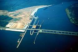
Pickwick Lake is the reservoir created by Pickwick Landing Dam as part of the Tennessee Valley Authority. The lake stretches from Pickwick Landing Dam to Wilson Dam.
Pickwick Lake has excellent sportfishing areas, including the Wilson Dam tailwater at the upper end of the reservoir, noted for record-size smallmouth bass and catfish. Another favorite spot is the discharge basin at Colbert Fossil Plant west of Sheffield, Alabama, where the warm water discharged from the power plant attracts fish during cold weather. The lakeshore plays host to two state parks: Tennessee's Pickwick Landing State Park and Mississippi's J P Coleman State Park.
Pickwick Lake is the north end of the Tennessee-Tombigbee Waterway, which provides a water transportation route to the Gulf of Mexico.
Yellow Creek Cove is home to the Yellow Creek waterfall and is a popular destination for boaters. A rope swing off the top of the waterfall has been present for many years.
See also
References
- "Pickwick Lake". Geographic Names Information System. United States Geological Survey. Retrieved 2006-05-02.
External links
- Tennessee Valley Authority: Pickwick Reservoir
- Fishing Pickwick Lake Smallmouth Bass, Largemouth Bass, Crappie, and Sauger
Further reading
- Grimsley, Rheta, "Dirty Little Story," Southern Spaces, 6 September 2012.