Adams County, Indiana
| Adams County, Indiana | |
|---|---|
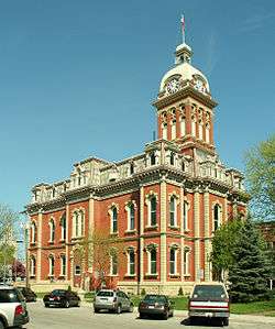 Adams County courthouse in Decatur | |
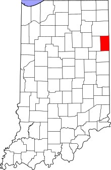 Location in the U.S. state of Indiana | |
 Indiana's location in the U.S. | |
| Founded | 1 March 1836 |
| Named for | John Quincy Adams |
| Seat | Decatur |
| Largest city | Decatur |
| Area | |
| • Total | 339.97 sq mi (881 km2) |
| • Land | 339.03 sq mi (878 km2) |
| • Water | 0.94 sq mi (2 km2), 0.28% |
| Population (est.) | |
| • (2017) | 35,491[1] |
| • Density | 105/sq mi (41/km2) |
| Congressional district | 3rd |
| Time zone | Eastern: UTC−5/−4 |
|
Footnotes: FIPS No. 001[2] | |
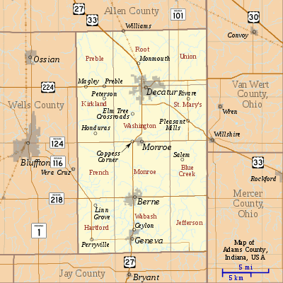
Adams County lies in northeastern Indiana in the United States and shares its eastern border with Ohio. It was officially established in 1836. The county seat is Decatur.[3]
According to the 2010 census, its population was 34,387, an increase of 2.27% from 33,625 in 2000.[4] The county has four incorporated cities and towns with a total population of over 15,000,[5] as well as many small unincorporated communities. The county is divided into 12 townships which provide local services.[6][7] There are four Indiana state roads in the county, as well as three U.S. Routes and one railroad line.[8][9]
In 2017, about a quarter of the county's population (estimated 8,600) was Swiss Amish.[10]
History
The statute that mandated creation of this county was passed on 7 February 1835, and the organization itself was authorized on 1 March 1836. Its name honors the sixth President of the United States, John Quincy Adams.[11] Selection of the county seat was finalized on 18 May of that year.[12]
The first non-Native settlers arrived in what is now Adams County in 1835, encouraged by the new Erie Canal and by the end of the Black Hawk War. They consisted entirely of settlers from New England. These were "Yankee" settlers, that is to say they were descended from the English Puritans who settled New England in the colonial era. They were primarily members of the Congregational Church though due to the Second Great Awakening many of them had converted to Methodism and some had become Baptists before coming to what is now Adams County. The Congregational Church subsequently has gone through many divisions and some factions are now known as the Church of Christ and the United Church of Christ. When these settlers arrived they found dense forest and wild prairie.[13]
The first Amish settlers arrived in 1840; most came directly from Switzerland, preserving their Bernese German dialect, not adopting the Pennsylvania German dialect of the majority of the Amish.[14][15]
The Yankee settlers commissioned the first courthouse in 1839, a two-story frame building. The log-building jail was completed in 1837.[16] The present Adams County courthouse was built in Decatur in 1872–1873 at a cost of $78,979.[n 1] The designer was J. C. Johnson, who had been trained as a carpenter and joiner and became a self-taught architect; he won second place in the Indiana State Capitol design competition. The construction was done by Christian Boseker of Fort Wayne. It is built of red brick with stone ornamentation.[18]
Geography
According to the 2010 census, the county has a total area of 339.97 square miles (880.5 km2), of which 339.03 square miles (878.1 km2) (or 99.72%) is land and 0.94 square miles (2.4 km2) (or 0.28%) is water.[19]
Adjacent counties
- Allen County (north)
- Wells County (west)
- Jay County (south)
- Van Wert, Ohio (northeast)
- Mercer, Ohio (southeast)
The county has four incorporated settlements, all of which lie in a rough north–south line. The city of Decatur is the largest and is also the county seat, and is in the northern part of the county where U.S. Route 27 and U.S. Route 33 intersect with the east–west U.S. Route 224. U.S. Route 27 continues south through the town of Monroe, near the center of the county, and then on through Berne and Geneva.
Cities
Unincorporated communities
- Ceylon
- Coppess Corner
- Curryville
- Elm Tree Crossroads
- Honduras
- Linn Grove
- Magley
- Monmouth
- Perryville
- Peterson
- Pleasant Mills
- Preble
- Rivare (Bobo)
- Salem
- Williams
Townships
Climate and weather
| Decatur, Indiana | ||||||||||||||||||||||||||||||||||||||||||||||||||||||||||||
|---|---|---|---|---|---|---|---|---|---|---|---|---|---|---|---|---|---|---|---|---|---|---|---|---|---|---|---|---|---|---|---|---|---|---|---|---|---|---|---|---|---|---|---|---|---|---|---|---|---|---|---|---|---|---|---|---|---|---|---|---|
| Climate chart (explanation) | ||||||||||||||||||||||||||||||||||||||||||||||||||||||||||||
| ||||||||||||||||||||||||||||||||||||||||||||||||||||||||||||
| ||||||||||||||||||||||||||||||||||||||||||||||||||||||||||||
Adams County is in the humid continental climate region of the United States along with most of Indiana. Its Köppen climate classification is Dfa,[21] meaning that it is cold, has no dry season, and has a hot summer.[22] In recent years, average temperatures in Decatur have ranged from a low of 17 °F (−8 °C) in January to a high of 84 °F (29 °C) in July, although a record low of −24 °F (−31 °C) was recorded in January 1985 and a record high of 107 °F (42 °C) was recorded in July 1934. Average monthly precipitation ranged from 2.16 inches (55 mm) in February to 4.42 inches (112 mm) in June.[20]
Demographics
| Historical population | |||
|---|---|---|---|
| Census | Pop. | %± | |
| 1840 | 2,264 | — | |
| 1850 | 5,797 | 156.1% | |
| 1860 | 9,252 | 59.6% | |
| 1870 | 11,382 | 23.0% | |
| 1880 | 15,385 | 35.2% | |
| 1890 | 20,181 | 31.2% | |
| 1900 | 22,232 | 10.2% | |
| 1910 | 21,840 | −1.8% | |
| 1920 | 20,503 | −6.1% | |
| 1930 | 19,957 | −2.7% | |
| 1940 | 21,254 | 6.5% | |
| 1950 | 22,393 | 5.4% | |
| 1960 | 24,643 | 10.0% | |
| 1970 | 26,871 | 9.0% | |
| 1980 | 29,619 | 10.2% | |
| 1990 | 31,095 | 5.0% | |
| 2000 | 33,625 | 8.1% | |
| 2010 | 34,387 | 2.3% | |
| Est. 2017 | 35,491 | [23] | 3.2% |
| U.S. Decennial Census[24] 1790-1960[25] 1900-1990[26] 1990-2000[27] 2010-2015[4] | |||
As of the 2010 United States Census, there were 34,387 people, 12,011 households, and 8,673 families residing in the county.[5] The population density was 101.4 inhabitants per square mile (39.2/km2). There were 13,014 housing units at an average density of 38.4 per square mile (14.8/km2).[19] The racial makeup of the county was 97.0% white, 0.3% black or African American, 0.2% Asian, 0.2% American Indian, 1.4% from other races, and 0.9% from two or more races. Those of Hispanic or Latino origin made up 4.1% of the population.[5] In terms of ancestry, 42.9% were German, 8.2% were Irish, 7.9% were American, and 6.9% were English.[28]
Of the 12,011 households, 36.3% had children under the age of 18 living with them, 59.4% were married couples living together, 8.9% had a female householder with no husband present, 27.8% were non-families, and 24.6% of all households were made up of individuals. The average household size was 2.83 and the average family size was 3.41. The median age was 34.0 years.[5]
The median income for a household in the county was $47,697 and the median income for a family was $53,106. Males had a median income of $40,133 versus $29,907 for females. The per capita income for the county was $19,089. About 11.8% of families and 16.3% of the population were below the poverty line, including 26.9% of those under age 18 and 7.7% of those age 65 or over.[29]
Amish community
The Amish (Swiss Amish) community in Adams County, whose antecedents trace to 1840, speak a Bernese dialect in everyday life. They had a total population of 8,595 people in 58 congregations in 2017,[10] or 24.2% of the county's population.
Transportation
Three U.S Routes cross the county. U.S. Route 27 and U.S. Route 33 enter the north end of the county from Fort Wayne in neighboring Allen County. Passing through Decatur, they split; U.S. Route 27 goes south through Monroe, Berne and Geneva and continues into Jay County, whereas U.S. Route 33 heads southeast into Ohio.[30][31] U.S. Route 224 passes from west to east through the north part of the county, intersecting U.S. Routes 27 and 33 in Decatur, then continuing into Ohio.[32]
Indiana State Road 124 runs east–west through the county, from Bluffton in Wells County through Monroe and on to the Ohio border.[33] Indiana State Road 101 runs south–north, from State Road 124 near the Ohio border, through Pleasant Mills and Rivare, to Allen County.[34] Indiana State Road 116 runs west–east across the county, from Bluffton southeast to Linn Grove, south to Perryville, then east to a terminus at U.S. Route 27 in Geneva.[35] Indiana State Road 218 runs west–east across the southern end of the county, passing through Berne.[36]
CSX Transportation operates a rail line from Decatur, running northwest toward Fort Wayne.[9]
Government

The county government is a constitutional body granted specific powers by the Constitution of Indiana and the Indiana Code. The county council is the legislative branch of the county government and controls all spending and revenue collection. Representatives are elected from county districts. The council members serve four-year terms and are responsible for setting salaries, the annual budget and special spending. The council also has limited authority to impose local taxes, in the form of an income and property tax that is subject to state level approval, excise taxes and service taxes.[37][38] In 2010, the county budgeted approximately $2.2 million for the district's schools and $2.8 million for other county operations and services, for a total annual budget of approximately $5 million.[39]
A Board of Commissioners forms the county's executive body. They are elected county-wide, in staggered four–year terms. One commissioner serves as Board President. This board executes the acts of the council, causes necessary revenues to be collected, and manages day-to-day functions of the county government.[37][38]
The county maintains a small claims court. This court's judge is elected to a term of four years and must be a member of the Indiana Bar Association. The judge is assisted by a constable who is elected to a four-year term. In some cases, court decisions can be appealed to the state level circuit court.[38]
The county has other elected offices, including sheriff, coroner, auditor, treasurer, recorder, surveyor and circuit court clerk. Each of these serves a term of four years and oversees a different part of county government. Members elected to county government positions are required to declare party affiliations and be residents of the county.[38]
Each township has a trustee who administers rural fire protection and ambulance service, provides poor relief, and manages cemetery care.[7] The trustee is assisted by a three-member township board. The trustees and board members are elected to four-year terms.[40]
Adams County is part of Indiana's 3rd congressional district; Indiana Senate district 19;[41] and Indiana House of Representatives district 79.[42]
| Year | Republican | Democratic | Third parties |
|---|---|---|---|
| 2016 | 73.1% 9,648 | 21.3% 2,805 | 5.6% 741 |
| 2012 | 68.6% 8,937 | 29.2% 3,806 | 2.2% 289 |
| 2008 | 62.1% 8,404 | 36.4% 4,928 | 1.5% 207 |
| 2004 | 73.0% 9,734 | 26.3% 3,512 | 0.7% 94 |
| 2000 | 68.0% 8,555 | 30.0% 3,775 | 2.1% 260 |
| 1996 | 55.1% 6,960 | 33.6% 4,247 | 11.3% 1,430 |
| 1992 | 47.8% 6,078 | 29.2% 3,708 | 23.0% 2,922 |
| 1988 | 67.8% 8,137 | 31.8% 3,811 | 0.4% 49 |
| 1984 | 66.6% 7,958 | 32.8% 3,923 | 0.6% 71 |
| 1980 | 53.2% 6,368 | 39.0% 4,673 | 7.8% 937 |
| 1976 | 55.6% 6,280 | 43.4% 4,908 | 1.0% 118 |
| 1972 | 65.2% 7,549 | 34.3% 3,971 | 0.5% 52 |
| 1968 | 51.3% 5,774 | 41.5% 4,667 | 7.3% 818 |
| 1964 | 38.6% 4,230 | 60.5% 6,637 | 1.0% 106 |
| 1960 | 61.1% 6,972 | 38.0% 4,338 | 0.9% 99 |
| 1956 | 66.1% 7,079 | 32.9% 3,520 | 1.0% 109 |
| 1952 | 59.6% 6,204 | 36.0% 3,744 | 4.4% 460 |
| 1948 | 50.1% 4,832 | 48.1% 4,640 | 1.8% 173 |
| 1944 | 58.8% 5,648 | 39.6% 3,804 | 1.6% 149 |
| 1940 | 53.9% 5,247 | 45.0% 4,382 | 1.0% 101 |
| 1936 | 35.3% 3,249 | 63.2% 5,822 | 1.5% 137 |
| 1932 | 32.7% 2,910 | 66.1% 5,892 | 1.3% 111 |
| 1928 | 49.7% 4,045 | 50.0% 4,066 | 0.3% 28 |
| 1924 | 41.3% 3,330 | 53.4% 4,300 | 5.3% 425 |
| 1920 | 51.8% 4,144 | 45.7% 3,653 | 2.5% 201 |
| 1916 | 36.8% 1,796 | 59.0% 2,875 | 4.2% 205 |
| 1912 | 19.1% 917 | 61.6% 2,961 | 19.3% 927 |
| 1908 | 32.6% 1,726 | 64.4% 3,404 | 3.0% 159 |
| 1904 | 37.9% 1,967 | 57.3% 2,973 | 4.8% 247 |
| 1900 | 32.9% 1,688 | 65.1% 3,337 | 2.0% 101 |
| 1896 | 32.1% 1,613 | 66.5% 3,340 | 1.5% 73 |
| 1892 | 27.9% 1,247 | 65.1% 2,906 | 7.0% 314 |
| 1888 | 29.3% 1,277 | 67.3% 2,936 | 3.4% 150 |
Education
Public schools in Adams County are administered by three public entities: North Adams Community Schools; Adams Central Community Schools; and South Adams Schools. The Diocese of Fort Wayne and Lutheran Schools of Indiana both operate in Adams County as well. In all, these organizations operate 13 schools in the county.[44]
Festivals and Fairs in Adams County
- Adams County 4-H Fair (Monroe)
- Swiss Days (Berne)
- Calithumpian Festival (Decatur)
- Festival of Kekionga (Decatur)
Media
Radio
Newspapers
- The Decatur Daily Democrat (Decatur)
- Berne Tri-Weekly (Berne)
Notable people
- Gene Stratton-Porter (1863 – 1924), author, nature photographer, naturalist, and silent movie-era producer, lived in Decatur and Geneva 1886–1913.[45]
- Chemist Richard R. Schrock, 2005 Nobel Prize winner in organic chemistry, was born in Berne in 1945 and attended school in Decatur.[46]
- Director David Anspaugh (born 1946), who directed the movies Hoosiers and Rudy, was bor in Decatur.[47]
- Sculptor David Smith (1906 – 1965) was born in Decatur.[48]
See also
Notes
References
- ↑ "QuickFacts: Adams County, Indiana". U.S. Census Bureau. 2018. Retrieved 18 April 2018.
- ↑ "EPA County FIPS Code Listing". EPA.gov. Retrieved 12 August 2018.
- ↑ "Find a County – Adams County IN". National Association of Counties. Retrieved 10 October 2011.
- 1 2 "Adams County QuickFacts". United States Census Bureau. Archived from the original on 6 July 2011. Retrieved 17 September 2011.
- 1 2 3 4 "DP-1 Profile of General Population and Housing Characteristics: 2010 Demographic Profile Data". United States Census Bureau. Retrieved 10 July 2015.
- ↑ "Adams". Indiana Township Association. Retrieved 10 October 2011.
- 1 2 "Duties". United Township Association of Indiana. Retrieved 6 January 2011.
- ↑ "Indiana Transportation Map 2009–2010" (PDF). Indiana Department of Transportation. 2009. Archived from the original (PDF) on 15 December 2010. Retrieved 16 December 2010.
- 1 2 "State of Indiana 2011 Rail System Map" (PDF). Indiana Department of Transportation. 2011. Archived from the original (PDF) on 15 June 2011. Retrieved 19 June 2011.
- 1 2 The 12 Largest Amish Communities (2017). at Amish America
- ↑ Baker, Ronald L.; Carmony, Marvin (1975). Indiana Place Names. Bloomington, Indiana: Indiana University Press. p. 1.
- ↑ Goodrich, De Witt Clinton; Tuttle, Charles Richard (1875). An Illustrated History of the State of Indiana. Indianapolis: R. S. Peale & Co. pp. 549–550.
- ↑ Standard History of Adams and Wells Counties, Indiana by John Wilson Tyndall and Orlo Ervin Lesh, 1918
- ↑ Who are the Swiss Amish? at amishamerica.com
- ↑ The 10 Oldest Amish Settlements at amishamerica.com
- ↑ Snow 1907, p. 83.
- ↑ Williamson, Samuel H. (April 2010). Seven Ways to Compute the Relative Value of a U.S. Dollar Amount, 1774 to present. MeasuringWorth. Calculations made using Nominal GDP Per Capita, a measure of capital intensivity, using "the 'average' per-person output of the economy in the prices of the current year." This is a measure of the amount of capital and volume of labor required to reproduce the work over varying production methods, but assuming that money represents a proportion of the economy.
- ↑ Counts, Will; Jon Dilts (1991). The 92 Magnificent Indiana Courthouses. Bloomington, Indiana: Indiana University Press. pp. 8–9. ISBN 978-0-253-33638-5.
- 1 2 "Population, Housing Units, Area, and Density: 2010 - County". United States Census Bureau. Retrieved 10 July 2015.
- 1 2 "Monthly Averages for Decatur, Indiana". The Weather Channel. Retrieved 27 January 2011.
- ↑ "Köppen Climate Classification for the Conterminous United States". Idaho State Climate Services. Archived from the original on 30 September 2009. Retrieved 23 January 2011.
- ↑ Peel, M. C.; Finlayson, B. L.; McMahon, T. A. (2007). "Updated world map of the Köppen-Geiger climate classification" (PDF). Copernicus Publications. p. 1636. Retrieved 23 January 2011.
- ↑ "Population and Housing Unit Estimates". Retrieved 9 June 2017.
- ↑ "U.S. Decennial Census". United States Census Bureau. Archived from the original on 12 May 2015. Retrieved 10 July 2014.
- ↑ "Historical Census Browser". University of Virginia Library. Retrieved 10 July 2014.
- ↑ "Population of Counties by Decennial Census: 1900 to 1990". United States Census Bureau. Retrieved 10 July 2014.
- ↑ "Census 2000 PHC-T-4. Ranking Tables for Counties: 1990 and 2000" (PDF). United States Census Bureau. Retrieved 10 July 2014.
- ↑ "Selected Social Characteristics in the United States – 2006-2010 American Community Survey 5-Year Estimates". United States Census Bureau. Retrieved 10 July 2015.
- ↑ "Selected Economic Characteristics – 2006-2010 American Community Survey 5-Year Estimates". United States Census Bureau. Retrieved 10 July 2015.
- ↑ "U.S. Route 27". Highway Explorer. Archived from the original on 15 October 2012. Retrieved 12 October 2011.
- ↑ "U.S. Route 33". Highway Explorer. Archived from the original on 7 October 2011. Retrieved 12 October 2011.
- ↑ "U.S. Route 224". Highway Explorer. Archived from the original on 13 October 2012. Retrieved 12 October 2011.
- ↑ "State Road 124". Highway Explorer. Archived from the original on 24 March 2012. Retrieved 12 October 2011.
- ↑ "State Road 101". Highway Explorer. Archived from the original on 7 October 2011. Retrieved 12 October 2011.
- ↑ "State Road 116". Highway Explorer. Archived from the original on 24 March 2012. Retrieved 12 October 2011.
- ↑ "State Road 218". Highway Explorer. Archived from the original on 7 October 2011. Retrieved 12 October 2011.
- 1 2 Indiana Code. "Title 36, Article 2, Section 3". Government of Indiana. Archived from the original on 5 October 2008. Retrieved 16 September 2008.
- 1 2 3 4 Indiana Code. "Title 2, Article 10, Section 2" (PDF). Government of Indiana. Archived (PDF) from the original on 29 October 2008. Retrieved 16 September 2008.
- ↑ State of Indiana Department of Local Government Finance. "2010 Budget Order (Adams County, Indiana)" (PDF). Archived from the original (PDF) on 17 September 2010. Retrieved 19 September 2010.
- ↑ "Government". United Township Association of Indiana. Retrieved 6 January 2011.
- ↑ "Indiana Senate Districts". State of Indiana. Archived from the original on 15 January 2011. Retrieved 23 January 2011.
- ↑ "Indiana House Districts". State of Indiana. Archived from the original on 15 January 2011. Retrieved 23 January 2011.
- ↑ Leip, David. "Dave Leip's Atlas of U.S. Presidential Elections". uselectionatlas.org. Retrieved 14 May 2018.
- ↑ "DOE Compass". Indiana Department of Education. Retrieved 10 October 2011.
- ↑ Linda C. Gugin and James E. St. Clair, eds. (2015). Indiana's 200: The People Who Shaped the Hoosier State. Indianapolis: Indiana Historical Society Press. pp. 333–35. ISBN 978-0-87195-387-2.
- ↑ "Richard R. Schrock - Autobiography". Nobelprize.org. Retrieved 11 October 2011.
- ↑ "Overview for David Anspaugh". Turner Classic Movies. Retrieved 11 October 2011.
- ↑ "David Smith chronology". David Smith Estate. Archived from the original on 11 October 2011. Retrieved 11 October 2011.
Bibliography
- Snow, J. F. (1907). Snow's History of Adams County, Indiana. Indianapolis: B. F. Bowen & Co.
- Tyndall, John W.; Lesh, O. E., eds. (1918). Standard History of Adams and Wells Counties, Indiana. 1. Chicago and New York: The Lewis Publishing Co.
- Tyndall, John W.; Lesh, O. E., eds. (1918). Standard History of Adams and Wells Counties, Indiana. 2. Chicago and New York: The Lewis Publishing Co.
External links
- County website
- Maumee Valley Heritage Corridor
- Adams County InDepth Profile: STATS Indiana
- County Highlights: Adams County: Hoosiers by the Numbers
Places adjacent to Adams County, Indiana | ||||||||||
|---|---|---|---|---|---|---|---|---|---|---|
| ||||||||||
Municipalities and communities of Adams County, Indiana, United States | ||
|---|---|---|
| Cities | ||
| Towns | ||
| Townships | ||
| Unincorporated communities |
| |
| Counties |  | |
|---|---|---|
| Municipalities with population over 10,000 in 2010 | ||
| Municipalities with population 1,000-10,000 in 2010 | ||
| Municipalities with population under 1,000 in 2010 | ||
| CDPs | ||
