Albion, Indiana
| Albion, Indiana | |
|---|---|
| Town | |
| Town of Albion | |
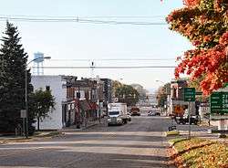 Downtown Albion | |
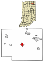 Location of Albion in Noble County, Indiana. | |
| Coordinates: 41°23′42″N 85°25′19″W / 41.39500°N 85.42194°WCoordinates: 41°23′42″N 85°25′19″W / 41.39500°N 85.42194°W | |
| Country | United States |
| State | Indiana |
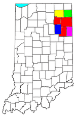
| County | Noble |
| Townships | Albion, Jefferson |
| Area[1] | |
| • Total | 1.91 sq mi (4.94 km2) |
| • Land | 1.91 sq mi (4.94 km2) |
| • Water | 0.00 sq mi (0.00 km2) |
| Elevation[2] | 955 ft (291 m) |
| Population (2010)[3] | |
| • Total | 2,349 |
| • Estimate (2016)[4] | 2,320 |
| • Density | 1,215.93/sq mi (469.46/km2) |
| Time zone | UTC−5 (Eastern (EST)) |
| • Summer (DST) | UTC−5 (EST) |
| ZIP code | 46701 |
| Area code | 260 |
| FIPS code[5] | 18-00820 |
| GNIS ID[5] | 430044 |
| Website |
www |
Albion is a town in Albion and Jefferson townships, Noble County, in the U.S. state of Indiana.[6] The population was 2,349 at the 2010 census. The city is the county seat of Noble County.[7]
History
Albion was laid out in 1846.[8] The town was named after Albion, New York.[9] A post office has been in operation at Albion since 1847.[10]
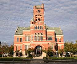
The Albion Courthouse Square Historic District, Noble County Courthouse, and Noble County Sheriff's House and Jail are listed on the National Register of Historic Places.[11]
Geography
Albion is located at 41°23′42″N 85°25′19″W / 41.39500°N 85.42194°W (41.395132, -85.422026).[12]
According to the 2010 census, Albion has a total area of 1.91 square miles (4.95 km2), all land.[13]
Demographics
| Historical population | |||
|---|---|---|---|
| Census | Pop. | %± | |
| 1870 | 476 | — | |
| 1880 | 926 | 94.5% | |
| 1890 | 1,229 | 32.7% | |
| 1900 | 1,324 | 7.7% | |
| 1910 | 1,213 | −8.4% | |
| 1920 | 1,142 | −5.9% | |
| 1930 | 1,108 | −3.0% | |
| 1940 | 1,234 | 11.4% | |
| 1950 | 1,341 | 8.7% | |
| 1960 | 1,325 | −1.2% | |
| 1970 | 1,498 | 13.1% | |
| 1980 | 1,637 | 9.3% | |
| 1990 | 1,823 | 11.4% | |
| 2000 | 2,284 | 25.3% | |
| 2010 | 2,349 | 2.8% | |
| Est. 2016 | 2,320 | [4] | −1.2% |
| U.S. Decennial Census[14] | |||
2010 census
As of the 2010 census,[3] there were 2,349 people, 831 households, and 530 families residing in the town. The population density was 1,229.8 inhabitants per square mile (474.8/km2). There were 951 housing units at an average density of 497.9 per square mile (192.2/km2). The racial makeup of the town was 97.4% White, 0.4% African American, 0.2% Native American, 0.4% Asian, 0.6% from other races, and 1.1% from two or more races. Hispanic or Latino of any race were 3.2% of the population.
There were 831 households of which 35.7% had children under the age of 18 living with them, 44.0% were married couples living together, 14.4% had a female householder with no husband present, 5.3% had a male householder with no wife present, and 36.2% were non-families. 30.4% of all households were made up of individuals and 12.2% had someone living alone who was 65 years of age or older. The average household size was 2.46 and the average family size was 3.04.
The median age in the town was 35.3 years. 24.8% of residents were under the age of 18; 8.8% were between the ages of 18 and 24; 30.1% were from 25 to 44; 22% were from 45 to 64; and 14.2% were 65 years of age or older. The gender makeup of the town was 51.1% male and 48.9% female.
2000 census
As of the 2000 census,[15] there were 2,284 people, 846 households, and 555 families residing in the town. The population density was 1,636.5 people per square mile (629.9/km²). There were 912 housing units at an average density of 653.5 per square mile (251.5/km²). The racial makeup of the town was 97.37% White, 0.92% African American, 0.35% Native American, 0.04% Asian, 0.88% from other races, and 0.44% from two or more races. Hispanic or Latino of any race were 1.31% of the population.
There were 846 households out of which 37.1% had children under the age of 18 living with them, 47.8% were married couples living together, 12.6% had a female householder with no husband present, and 34.3% were non-families. 29.7% of all households were made up of individuals and 10.2% had someone living alone who was 65 years of age or older. The average household size was 2.51 and the average family size was 3.10.
In the town, the population was spread out with 29.2% under the age of 18, 10.3% from 18 to 24, 33.2% from 25 to 44, 17.0% from 45 to 64, and 10.2% who were 65 years of age or older. The median age was 30 years. For every 100 females, there were 110.7 males. For every 100 females age 18 and over, there were 108.2 males.
The median income for a household in the town was $36,282, and the median income for a family was $43,438. Males had a median income of $31,473 versus $23,531 for females. The per capita income for the town was $16,405. About 4.6% of families and 4.7% of the population were below the poverty line, including 6.7% of those under age 18 and 5.3% of those age 65 or over.
Education
Children living in Albion go to either Central Noble High School, Central Noble Middle School, or Albion Elementary School.
Albion has a public library, a branch of the Noble County Public Library.[16]
Notable natives
- Earl Butz (died February 2, 2008), former United States Secretary of Agriculture
- Kyle Macy, All-American Basketball player
- Donald H. Spangler, Naval officer, USS Spangler (DE-696) named for him.
References
- ↑ "2016 U.S. Gazetteer Files". United States Census Bureau. Retrieved Jul 28, 2017.
- ↑ "US Board on Geographic Names". United States Geological Survey. October 25, 2007. Retrieved 2017-05-05.
- 1 2 "American FactFinder". United States Census Bureau. Retrieved 2012-12-11.
- 1 2 "Population and Housing Unit Estimates". Retrieved June 9, 2017.
- 1 2 "FIPS55 Data: Indiana". FIPS55 Data]. United States Geological Survey. February 23, 2006. Archived from the original on June 18, 2006. Retrieved June 28, 2014.
- ↑ "Albion, Indiana". Geographic Names Information System. United States Geological Survey. Retrieved 2017-05-05.
- ↑ "Find a County". National Association of Counties. Archived from the original on 2011-05-31. Retrieved 2011-06-07.
- ↑ Counties of LaGrange and Noble, Indiana: Historical and Biographical. F.A. Battey & Company. 1882. p. 169.
- ↑ Baker, Ronald L. (October 1995). From Needmore to Prosperity: Hoosier Place Names in Folklore and History. Indiana University Press. p. 47. ISBN 978-0-253-32866-3.
...via Albion, New York, home of a county commissioner.
- ↑ "Noble County". Jim Forte Postal History. Retrieved 13 September 2015.
- ↑ National Park Service (2010-07-09). "National Register Information System". National Register of Historic Places. National Park Service.
- ↑ "US Gazetteer files: 2010, 2000, and 1990". United States Census Bureau. 2011-02-12. Retrieved 2011-04-23.
- ↑ "G001 - Geographic Identifiers - 2010 Census Summary File 1". United States Census Bureau. Retrieved 2015-07-13.
- ↑ "Census of Population and Housing". Census.gov. Archived from the original on May 12, 2015. Retrieved June 4, 2015.
- ↑ "American FactFinder". United States Census Bureau. Archived from the original on 2013-09-11. Retrieved 2008-01-31.
- ↑ "Indiana public library directory" (PDF). Indiana State Library. Retrieved 14 March 2018.
External links
- Town of Albion, Indiana website
- Noble County Historical Society - local history
- KPC News - local newspaper
- Albion New Era - local newspaper
Municipalities and communities of Noble County, Indiana, United States | ||
|---|---|---|
| Cities | ||
| Towns | ||
| Townships | ||
| CDP | ||
| Unincorporated communities | ||
| Footnotes | ‡This populated place also has portions in an adjacent county or counties | |