Tippecanoe County, Indiana
| Tippecanoe County, Indiana | |
|---|---|
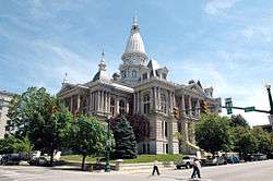 Tippecanoe County courthouse in Lafayette, Indiana | |
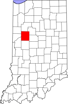 Location in the U.S. state of Indiana | |
 Indiana's location in the U.S. | |
| Founded | March 1, 1826 |
| Named for | Kethtippecanoogi ("Place of the Succor Fish People" in Miami) |
| Seat | Lafayette |
| Largest city | Lafayette |
| Area | |
| • Total | 503.24 sq mi (1,303 km2) |
| • Land | 499.81 sq mi (1,295 km2) |
| • Water | 3.44 sq mi (9 km2), 0.68% |
| Population | |
| • (2010) | 172,780 |
| • Density | 346/sq mi (133.48/km2) |
| Congressional district | 4th |
| Time zone | Eastern: UTC−5/−4 |
| Website |
www |
|
Footnotes: Indiana county number 79 | |
Tippecanoe County is a county located in the northwest quadrant of the U.S. state of Indiana. As of the 2010 census, the population was 172,780.[1] The county seat is Lafayette.[2] It was created in 1826 from Wabash County.[3]
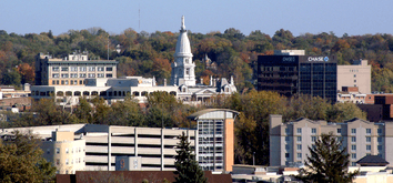
Tippecanoe County is part of the Lafayette, Indiana, Metropolitan Statistical Area.
History
Tippecanoe County was formed March 1, 1826, and named for the anglicization of "Kethtippecanoogi", a Miami people term meaning "place of the succor fish people." (Kriebel, Robert C. - Tippecanoe at 2000: A Hoosier County Recalls Its Past). The county is best known for Purdue University, the 1811 Battle of Tippecanoe, and the Tippecanoe County Courthouse, a structure built in 1881 and included in the National Register of Historic Places.
Geography
According to the 2010 census, the county has a total area of 503.24 square miles (1,303.4 km2), of which 499.81 square miles (1,294.5 km2) (or 99.32%) is land and 3.44 square miles (8.9 km2) (or 0.68%) is water.[4]
Adjacent counties
- White County (north)
- Carroll County (northeast)
- Clinton County (east)
- Montgomery County (south)
- Fountain County (southwest)
- Warren County (west)
- Benton County (northwest)
Communities
Cities
- Lafayette
- West Lafayette (home of Purdue University)
Towns
- Battle Ground
- Clarks Hill
- Dayton
- Otterbein (east half)
- Shadeland
Census-designated places
- Americus
- Buck Creek (formerly Transitville)
- Colburn (formerly Chapmanville)
- Montmorenci (formerly Bringham's Grove)
- Stockwell (formerly Lauramie)
- West Point (formerly Middleton)
Other unincorporated places
- Altamont Switch
- Ash Grove
- Cairo
- Concord
- Delp
- Eastwich
- Glen Hall
- Monroe (formerly Huntersville)
- Norma Jean Addition
- Octagon
- Odell
- Old Halfway
- Pettit
- Romney (formerly Columbia)
- Taylor
Extinct
- Archerville
- Beeville
- Chauncey (consolidated into West Lafayette)
- Corwin
- Columbus
- Cincinnatus[5]
- Clarksburg
- Cleveland
- Conroe
- Erie
- Florentine
- Fulton (absorbed by Lafayette)
- Gerard
- Granville (aka Weaton)
- Heath
- Harrisonville (consolidated into Battle Ground)
- Kingston (consolidated into West Lafayette)
- LaGrange
- Linwood (absorbed by Lafayette)
- Little Chicago
- Monitor (formerly Cynthyana)
- New Market
- North Crane
- Oakland (absorbed by Lafayette)
- Ouiatenon
- Polk-White Corners
- Prairieville
- Sidney
- South Raub
- Sugar Grove
- Sunberry
- Texas
- Wheeler's Grove
- Wyandot
- Yorktown
Townships

Climate and weather
| Lafayette, Indiana | ||||||||||||||||||||||||||||||||||||||||||||||||||||||||||||
|---|---|---|---|---|---|---|---|---|---|---|---|---|---|---|---|---|---|---|---|---|---|---|---|---|---|---|---|---|---|---|---|---|---|---|---|---|---|---|---|---|---|---|---|---|---|---|---|---|---|---|---|---|---|---|---|---|---|---|---|---|
| Climate chart (explanation) | ||||||||||||||||||||||||||||||||||||||||||||||||||||||||||||
| ||||||||||||||||||||||||||||||||||||||||||||||||||||||||||||
| ||||||||||||||||||||||||||||||||||||||||||||||||||||||||||||
In recent years, temperatures in Lafayette have ranged from an average low of 17 °F (−8 °C) in January to a high of 86 °F (30 °C) in July, although a record low of −23 °F (−31 °C) was recorded in January 1985 and a record high of 105 °F (41 °C) was recorded in June 1988. Average monthly precipitation ranged from 1.58 inches (40 mm) inches in February to 4.24 inches (108 mm) inches in June.[6]
Transportation
Highways
Railroads
Three different railroad lines intersect in Tippecanoe County, all running through the Lafayette area. CSX Transportation operates a north-south line; Norfolk Southern Railway operates a southwest-to-northeast line,[7] and the Kankakee, Beaverville and Southern Railroad operates a daily-service line running from the northwest to the southeast.
Airport
The county contains one public-use airport: Purdue University Airport (LAF) in West Lafayette, Indiana.[8]
Government
The county government is a constitutional body, and is granted specific powers by the Constitution of Indiana, and by the Indiana Code.
County Council: The county council is the fiscal branch of the county government and controls all the spending and revenue collection in the county. The county council and the board of commissioners share legislative authority. [9] Representatives are elected from county districts. The council members serve four-year terms. They are responsible for setting salaries, the annual budget, and special spending. The council also has limited authority to impose local taxes, in the form of an income and property tax that is subject to state level approval, excise taxes, and service taxes.[10][11]
Board of Commissioners: The executive body of the county is made of a board of commissioners. The commissioners are elected county-wide, in staggered terms, and each serves a four-year term. One of the commissioners, typically the most senior, serves as president. The commissioners are charged with executing the acts legislated by the council, collecting revenue, and managing the day-to-day functions of the county government.[10][11]
Court: The county maintains a small claims court that can handle some civil cases. The judge on the court is elected to a term of four years and must be a member of the Indiana Bar Association. The judge is assisted by a constable who is also elected to a four-year term. In some cases, court decisions can be appealed to the state level circuit court.[11]
County Officials: The county has several other elected offices, including sheriff, coroner, auditor, treasurer, recorder, surveyor, and circuit court clerk. Each of these elected officers serves a term of four years and oversees a different part of county government. Members elected to county government positions are required to declare party affiliations and to be residents of the county.[11]
Politics
In the 2008 Democratic primary, Tippecanoe County was one of 10 (out of 92) Indiana counties to give the majority of its votes to Barack Obama.[12] In the 2008 Presidential election, Tippecanoe County was one of 15 Indiana counties to give the majority of its votes to Obama/Biden. Thanks to the sizable support of Purdue University students, Tippecanoe County played a pivotal role in Barack Obama's upset win in Indiana (49.9%-49.0%; 1,367,264 votes to 1,341,101 votes) by supporting the Democrat ticket of Barack Obama/Joe Biden 55.1%-43.5% over the Republican ticket of John McCain/Sarah Palin.[13]
| Year | Republican | Democratic | Third parties |
|---|---|---|---|
| 2016 | 48.6% 30,768 | 43.1% 27,282 | 8.4% 5,289 |
| 2012 | 50.4% 28,757 | 46.8% 26,711 | 2.8% 1,595 |
| 2008 | 43.5% 29,822 | 55.1% 37,781 | 1.5% 1,033 |
| 2004 | 59.0% 30,897 | 39.8% 20,818 | 1.2% 645 |
| 2000 | 56.4% 26,106 | 39.4% 18,220 | 4.3% 1,969 |
| 1996 | 49.5% 22,556 | 37.8% 17,232 | 12.7% 5,798 |
| 1992 | 45.8% 23,050 | 34.5% 17,343 | 19.8% 9,941 |
| 1988 | 62.9% 27,897 | 36.6% 16,256 | 0.5% 211 |
| 1984 | 64.8% 29,706 | 34.4% 15,789 | 0.8% 381 |
| 1980 | 56.9% 27,589 | 30.2% 14,636 | 12.9% 6,245 |
| 1976 | 61.3% 29,186 | 37.5% 17,850 | 1.2% 551 |
| 1972 | 68.1% 31,565 | 31.5% 14,598 | 0.4% 203 |
| 1968 | 59.4% 24,352 | 35.5% 14,528 | 5.1% 2,088 |
| 1964 | 48.4% 19,036 | 51.5% 20,257 | 0.2% 79 |
| 1960 | 63.6% 24,572 | 36.3% 14,041 | 0.1% 55 |
| 1956 | 70.3% 23,776 | 29.5% 9,995 | 0.2% 72 |
| 1952 | 70.5% 23,447 | 29.1% 9,678 | 0.4% 121 |
| 1948 | 60.6% 17,034 | 38.5% 10,825 | 0.9% 248 |
| 1944 | 60.6% 15,888 | 39.0% 10,229 | 0.4% 95 |
| 1940 | 57.0% 16,148 | 42.8% 12,129 | 0.3% 73 |
| 1936 | 50.1% 13,081 | 48.7% 12,732 | 1.2% 309 |
| 1932 | 46.1% 11,818 | 53.0% 13,609 | 0.9% 236 |
| 1928 | 63.3% 15,165 | 36.4% 8,720 | 0.4% 93 |
| 1924 | 58.4% 12,161 | 36.6% 7,619 | 5.0% 1,043 |
| 1920 | 61.7% 12,730 | 36.6% 7,562 | 1.7% 347 |
| 1916 | 54.7% 6,386 | 42.2% 4,918 | 3.1% 365 |
| 1912 | 28.2% 3,006 | 41.7% 4,442 | 30.1% 3,205 |
| 1908 | 53.4% 6,164 | 43.2% 4,984 | 3.4% 391 |
| 1904 | 59.8% 6,581 | 36.7% 4,031 | 3.5% 388 |
| 1900 | 56.3% 6,317 | 41.6% 4,673 | 2.1% 232 |
| 1896 | 56.8% 6,239 | 42.2% 4,639 | 1.0% 111 |
| 1892 | 51.1% 4,856 | 46.2% 4,386 | 2.8% 261 |
| 1888 | 53.4% 5,072 | 45.1% 4,281 | 1.6% 147 |
Demographics
| Historical population | |||
|---|---|---|---|
| Census | Pop. | %± | |
| 1830 | 7,187 | — | |
| 1840 | 13,724 | 91.0% | |
| 1850 | 19,377 | 41.2% | |
| 1860 | 25,726 | 32.8% | |
| 1870 | 33,515 | 30.3% | |
| 1880 | 35,966 | 7.3% | |
| 1890 | 35,078 | −2.5% | |
| 1900 | 38,659 | 10.2% | |
| 1910 | 40,063 | 3.6% | |
| 1920 | 42,813 | 6.9% | |
| 1930 | 47,535 | 11.0% | |
| 1940 | 51,020 | 7.3% | |
| 1950 | 74,473 | 46.0% | |
| 1960 | 89,122 | 19.7% | |
| 1970 | 109,378 | 22.7% | |
| 1980 | 121,702 | 11.3% | |
| 1990 | 130,598 | 7.3% | |
| 2000 | 148,955 | 14.1% | |
| 2010 | 172,780 | 16.0% | |
| Est. 2016 | 188,059 | [15] | 8.8% |
| U.S. Decennial Census[16] 1790-1960[17] 1900-1990[18] 1990-2000[19] 2010-2013[1] | |||
As of the 2010 United States Census, there were 172,780 people, 65,532 households, and 37,003 families residing in the county.[20] The population density was 345.7 inhabitants per square mile (133.5/km2). There were 71,096 housing units at an average density of 142.2 per square mile (54.9/km2).[4] The racial makeup of the county was 84.0% white, 6.2% Asian, 4.0% black or African American, 0.3% American Indian, 3.3% from other races, and 2.2% from two or more races. Those of Hispanic or Latino origin made up 7.5% of the population.[20] In terms of ancestry, 27.5% were German, 13.9% were Irish, 10.8% were English, and 6.1% were American.[21]
Of the 65,532 households, 28.5% had children under the age of 18 living with them, 42.4% were married couples living together, 9.8% had a female householder with no husband present, 43.5% were non-families, and 29.2% of all households were made up of individuals. The average household size was 2.42 and the average family size was 3.02. The median age was 27.7 years.[20]
The median income for a household in the county was $47,697 and the median income for a family was $60,367. Males had a median income of $45,018 versus $31,995 for females. The per capita income for the county was $22,203. About 10.3% of families and 20.0% of the population were below the poverty line, including 18.2% of those under age 18 and 5.0% of those age 65 or over.[22]
Education
Public schools in rural/suburban Tippecanoe County are administered by the Tippecanoe School Corporation, while those in the cities are under either the Lafayette School Corporation or West Lafayette Community School Corporation. Purdue and Ivy Tech each have campuses at other sites in Indiana.
Libraries
Universities and colleges
High Schools
- Elston Community Education Center
- Lafayette Central Catholic Jr/Sr High School
- Lafayette (city) Jefferson High School
- Lafayette (city) Oakland High School
- Lafayette (suburban—south) McCutcheon High School
- West Lafayette (city) West Lafayette Junior-Senior High School
- West Lafayette/Lafayette (suburban—north) Harrison High School
Middle Schools/Junior High Schools
- Lafayette Sunnyside Middle School
- Lafayette Tecumseh Junior High School
- TSC (Harrison) Battle Ground Middle School
- TSC (Harrison) East Tipp Middle School
- TSC (Harrison) Klondike Middle School
- TSC (McCutcheon) Southwestern Middle School
- TSC (McCutcheon) Wainwright Middle School
- TSC (McCutcheon) Wea Ridge Middle School
- West Lafayette Junior-Senior High School
Elementary Schools
- Lafayette Edgelea Elementary School
- Lafayette Glen Acres Elementary School
- Lafayette Miami Elementary School
- Lafayette Miller Elementary School
- Lafayette Murdock Elementary School
- Lafayette (charter) New Community School
- Lafayette Vinton Elementary School
- TSC (Harrison) Battle Ground Elementary School
- TSC (Harrison) Burnett Creek Elementary School
- TSC (Harrison) Hershey Elementary School
- TSC (Harrison) Klondike Elementary School
- TSC (McCutcheon) Dayton Elementary School
- TSC (McCutcheon) James Cole Elementary School
- TSC (McCutcheon) Mayflower Mill Elementary School
- TSC (McCutcheon) Mintonye Elementary School
- TSC (McCutcheon) Wea Ridge Elementary School
- TSC (McCutcheon) Woodland Elementary School
- TSC (Harrison/McCutcheon) Wyandotte Elementary School
- West Lafayette Cumberland Elementary School
Private Schools
- Apostolic Christian Academy
- Beacon Academy
- Concord School
- Faith Christian School
- First Assembly Christian Academy
- Highland Christian School k-8
- Lafayette Catholic Schools k-12
- Lafayette Christian School k-8
- Lafayette Faith Baptist
- Lighthouse Baptist Christian Academy
- Pleasantview Christian School
- St Boniface 4-6
- St James Lutheran k-8
- St Mary Cathedral Elementary K-3
Economy
Much of the economy of Tippecanoe County is centered in its two largest communities: Lafayette and West Lafayette. Purdue University is by far the largest employer in the county, but private industry and commerce independent of the university also employ many others. Major employers include Subaru-Indiana Automotive, Wabash National, Caterpillar, Fairfield Manufacturing, Franciscan St. Elizabeth Health, Alcoa, State Farm, and IUHealth Arnett.
See also
References
- 1 2 "State & County QuickFacts". United States Census Bureau. Retrieved July 10, 2014.
- ↑ "Find a County". National Association of Counties. Retrieved 2011-06-07.
- ↑ DeHart 1909, p. 151.
- 1 2 "Population, Housing Units, Area, and Density: 2010 - County". United States Census Bureau. Retrieved 2015-07-10.
- ↑ http://www.ingenweb.org/intippecanoe/ghosttowns.htm
- 1 2 "Monthly Averages for Lafayette, Indiana". The Weather Channel. Retrieved 2011-01-27.
- ↑ "Indiana Railroads" (PDF). Indiana Department of Transportation. 2008. Archived from the original (PDF) on 2009-11-18. Retrieved 2010-12-11.
- ↑ Public and Private Airports, Tippecanoe County, Indiana
- ↑ "Guide to Indiana County Government" (PDF). Association of Indiana Counties. Retrieved October 27, 2016.
- 1 2 Indiana Code. "Title 36, Article 2, Section 3". IN.gov. Retrieved 2008-09-16.
- 1 2 3 4 Indiana Code. "Title 2, Article 10, Section 2" (PDF). IN.gov. Retrieved 2008-09-16.
- ↑ "Election Center 2008: Primary Results - Elections & Politics news from CNN.com". CNN. Retrieved May 25, 2010.
- ↑ "2008 presidential election results".
- ↑ Leip, David. "Dave Leip's Atlas of U.S. Presidential Elections". uselectionatlas.org. Retrieved 2018-05-20.
- ↑ "Population and Housing Unit Estimates". Retrieved June 9, 2017.
- ↑ "U.S. Decennial Census". United States Census Bureau. Retrieved July 10, 2014.
- ↑ "Historical Census Browser". University of Virginia Library. Retrieved July 10, 2014.
- ↑ "Population of Counties by Decennial Census: 1900 to 1990". United States Census Bureau. Retrieved July 10, 2014.
- ↑ "Census 2000 PHC-T-4. Ranking Tables for Counties: 1990 and 2000" (PDF). United States Census Bureau. Retrieved July 10, 2014.
- 1 2 3 "DP-1 Profile of General Population and Housing Characteristics: 2010 Demographic Profile Data". United States Census Bureau. Retrieved 2015-07-10.
- ↑ "DP02 SELECTED SOCIAL CHARACTERISTICS IN THE UNITED STATES – 2006-2010 American Community Survey 5-Year Estimates". United States Census Bureau. Retrieved 2015-07-10.
- ↑ "DP03 SELECTED ECONOMIC CHARACTERISTICS – 2006-2010 American Community Survey 5-Year Estimates". United States Census Bureau. Retrieved 2015-07-10.
- ↑ "Home - Tippecanoe County Public Library". tcpl.lib.in.us. Retrieved 2018-04-29.
- ↑ "West Lafayette Public Library - Home". wlaf.lib.in.us. Retrieved 2018-04-29.
Bibliography
- General R. P. DeHart, ed. (1909). Past and Present of Tippecanoe County Indiana. 1. Indianapolis: B. F. Bowen and Company. Retrieved 2010-12-11.
- General R. P. DeHart, ed. (1909). Past and Present of Tippecanoe County Indiana. 2. Indianapolis: B. F. Bowen and Company. Retrieved 2010-12-11.
External links
- Tippecanoe County official website
- Tippecanoe County Public Library
- Tippecanoe County Historical Association
- Lafayette Online
- Lafayette - West Lafayette Convention and Visitors Bureau
- GIS (Geographic Information System) for Tippecanoe County
- Lafayette Ski Club
Places adjacent to Tippecanoe County, Indiana | ||||||||||
|---|---|---|---|---|---|---|---|---|---|---|
| ||||||||||
Municipalities and communities of Tippecanoe County, Indiana, United States | ||
|---|---|---|
| Cities | ||
| Towns | ||
| Townships | ||
| CDPs | ||
| Other unincorporated communities |
| |
| Ghost towns | ||
| Footnotes | ‡This populated place also has portions in an adjacent county or counties | |
