Marion, Indiana
| Marion, Indiana | |
|---|---|
| City | |
| City of Marion | |
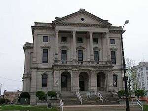 Grant County Courthouse | |
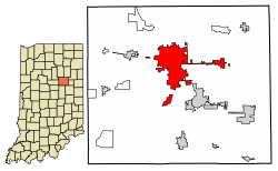 Location of Marion in Grant County, Indiana. | |
| Coordinates: 40°32′57″N 85°39′53″W / 40.54917°N 85.66472°WCoordinates: 40°32′57″N 85°39′53″W / 40.54917°N 85.66472°W | |
| Country | United States |
| State | Indiana |
| County | Grant |
| Government | |
| • Mayor | Jess Alumbaugh (D) |
| Area[1] | |
| • Total | 15.66 sq mi (40.56 km2) |
| • Land | 15.58 sq mi (40.35 km2) |
| • Water | 0.08 sq mi (0.22 km2) 0.51% |
| Elevation[2] | 810 ft (247 m) |
| Population (2010)[3] | |
| • Total | 29,948 |
| • Estimate (2016)[4] | 28,592 |
| • Density | 1,835.41/sq mi (708.67/km2) |
| Time zone | UTC-5 (EST) |
| • Summer (DST) | UTC-4 (EDT) |
| ZIP codes | 46952-46953 |
| Area code(s) | 765 |
| FIPS code | 18-46908[5] |
| GNIS feature ID | 438611 |
| Website | http://www.cityofmarion.in.gov/ |
Marion is a city in Grant County, Indiana, United States. The population was 29,948 as of the 2010 census. The city is the county seat of Grant County.[6] It is named for Francis Marion, a Brigadier General from South Carolina in the American Revolutionary War.
The city is the home of Indiana Wesleyan University, the largest evangelical Christian university in the Midwest and largest private university in Indiana—if including online and regional campuses in Indiana, Kentucky, Ohio, and Illinois. The traditional campus enrolls approximately 2800 students. Since 2016, Jess Alumbaugh has been Marion's mayor.
Marion is the birthplace of actor James Dean, and cartoonist Jim Davis. It was the location of the wedding of actress Julia Roberts and singer Lyle Lovett in 1993.[7]
In August 1930, the spectacle lynching of two African-American men, Thomas Shipp and Abram Smith, was committed by a mob of 5,000 whites at the courthouse square. These were the last two lynchings in Indiana. James Cameron was threatened with hanging, but spared.
Geography
Marion is located along the Mississinewa River.
According to the 2010 census, Marion has a total area of 15.794 square miles (40.91 km2), of which 15.71 square miles (40.69 km2) (or 99.47%) is land and 0.084 square miles (0.22 km2) (or 0.53%) is water.[8]
Demographics
| Historical population | |||
|---|---|---|---|
| Census | Pop. | %± | |
| 1850 | 703 | — | |
| 1870 | 1,658 | — | |
| 1880 | 3,182 | 91.9% | |
| 1890 | 8,759 | 175.3% | |
| 1900 | 17,337 | 97.9% | |
| 1910 | 19,359 | 11.7% | |
| 1920 | 23,747 | 22.7% | |
| 1930 | 24,496 | 3.2% | |
| 1940 | 26,767 | 9.3% | |
| 1950 | 30,081 | 12.4% | |
| 1960 | 37,854 | 25.8% | |
| 1970 | 39,607 | 4.6% | |
| 1980 | 35,874 | −9.4% | |
| 1990 | 32,618 | −9.1% | |
| 2000 | 31,320 | −4.0% | |
| 2010 | 29,948 | −4.4% | |
| Est. 2016 | 28,592 | [4] | −4.5% |
| Source: US Census Bureau | |||
2010 census
As of the census[3] of 2010, there were 29,948 people, 11,828 households, and 6,739 families residing in the city. The population density was 1,906.3 inhabitants per square mile (736.0/km2). There were 13,715 housing units at an average density of 873.0 per square mile (337.1/km2). The racial makeup of the city was 78.1% White, 14.7% African American, 0.4% Native American, 0.7% Asian, 2.4% from other races, and 3.6% from two or more races. Hispanic or Latino of any race were 5.5% of the population.
There were 11,828 households of which 27.9% had children under the age of 18 living with them, 35.2% were married couples living together, 17.0% had a female householder with no husband present, 4.8% had a male householder with no wife present, and 43.0% were non-families. 36.7% of all households were made up of individuals and 14.7% had someone living alone who was 65 years of age or older. The average household size was 2.25 and the average family size was 2.91.
The median age in the city was 36.2 years. 21.1% of residents were under the age of 18; 16.3% were between the ages of 18 and 24; 22.1% were from 25 to 44; 24.5% were from 45 to 64; and 16% were 65 years of age or older. The gender makeup of the city was 47.0% male and 53.0% female.
2000 census
As of the census[5] of 2000, there are 31,320 people. The population density is 2,355.5 people per square mile (909.2/km²). There are 13,820 housing units at an average density of 1,039.4 per square mile (401.2/km²). The racial makeup of the city is 79.64% White, 15.57% African American, 0.47% Native American, 0.68% Asian, 0.02% Pacific Islander, 1.43% from other races, and 2.18% from two or more races. 3.60% of the population are Hispanic or Latino of any race.
There are 12,462 households out of which 27.3% have children under the age of 18 living with them, 42.1% are married couples living together, 14.7% have a female householder with no husband present, and 38.8% are non-families. 33.8% of all households are made up of individuals and 14.2% have someone living alone who is 65 years of age or older. The average household size is 2.30 and the average family size is 2.91.
In the city, the population is spread out with 23.3% under the age of 18, 12.5% from 18 to 24, 26.0% from 25 to 44, 21.3% from 45 to 64, and 17.0% who are 65 years of age or older. The median age is 36 years. For every 100 females, there are 88.6 males. For every 100 females age 18 and over, there are 84.1 males.
The median income for a household in the city is $30,440, and the median income for a family is $37,717. Males have a median income of $30,258 versus $23,467 for females. The per capita income for the city is $16,378. 16.9% of the population and 12.6% of families are below the poverty line. Out of the total population, 23.8% of those under the age of 18 and 11.3% of those 65 and older are living below the poverty line.
History
The Battle of the Mississinewa was fought in December 1812, just north of the current city of Marion, as an expeditionary force sent by William Henry Harrison against the Miami villages. Today, the battle is reenacted every fall by residents of Grant County and many reenactors and enthusiasts from throughout the United States and Canada during the annual "Mississinewa 1812" festival, the largest War of 1812 reenactment in the United States.[9]
The Grant County Jail and Sheriff's Residence, Abijah C. Jay House, Marion Branch, National Home for Disabled Volunteer Soldiers Historic District, Marion Downtown Commercial Historic District, Aaron Swayzee House, George, Jr. and Marie Daugherty Webster House, and J. Woodrow Wilson House are listed on the National Register of Historic Places.[10]
Founding
When Martin Boots and David Branson each donated 30 acres (120,000 m2) of land in 1831 for the site of Marion, they chose a location on the left bank of the swift, scenic river which the Miami Indians had named "Mississinewa," meaning "Falling water." So rapid had been the tide of settlement that it followed by only 19 years the Battle of Mississinewa, 7 miles (11 km) downstream, where U.S. troops and Indians had fought a bloody, pre-dawn encounter in 1812.
With the formation of Grant County in 1831, Marion was established as the county seat and its future was assured. The river provided water supply, power, and drainage and it bequeathed a natural beauty as it flowed at the base of hills that marched away on either side. Along with at least 36 other communities in the U.S., Marion was named for the Revolutionary War General Francis Marion, the "Swamp Fox" of South Carolina.
Gas boom and growth

Marion grew slowly for more than 50 years as an agricultural trading center supported by a sprinkling of small farm- and forest-related industries. Native Americans were a common sight as they wandered in from Indiana's last reservation, with its Indian school, Baptist Church, and cemetery, 8 miles (13 km) away.
In the 1880s, fields of natural gas were discovered across much of east-central Indiana, and Grant County began to grow at a dizzying pace. Gas City and Matthews were carved out of raw farmland and launched as speculative boom towns, each absorbing existing tiny villages. They attracted several thousand residents before the gas failed and most industries left. As late as the 1940s, Matthews resembled a Western ghost town, before it attracted eleven glass factories and seduced the professional baseball team away from Indianapolis. Grant County's only covered bridge remains there as a link to the past.
However, the gas boom left its legacy. A few industries remained, particularly glass manufacturers.
National Home for Disabled Volunteer Soldiers
On July 23, 1888, with increasing number of residents at the six National Homes for Disabled Volunteer SoldiersHDVS), Congress established a seventh home in Grant County, Indiana (and ultimately three more). It is known as the Marion Branch. Congress allotted an appropriation of $200,000 for construction, while Grant County residents provided a natural gas supply for the heating and lighting of this new facility. Marion was selected as a site for the new branch due to the availability of natural gas and the political support of Colonel George W. Steele, Sr, US Congressman serving from 1880 to 1890.
This facility is now a part of the Veterans Administration (VA) Northern Indiana Health Care System, a dual-campus facility associated with the former VA Medical Center Fort Wayne. In the early 21st century, the original treatment hospital, built in 1889, the greenhouse, and cadet quarters are scheduled for demolition. There has been a lack of public support for funding restoration of these buildings. As they do not meet current standards, the Veterans Administration plans to demolish the buildings and replace them.
In the late 20th century, Marion surveyed its significant properties and defined the main buildings and grounds of the hospital as the Marion Branch Historic District. It is located at the intersection of 38th Street and Lincoln Boulevard, approximately 2½ miles southeast of the center of Marion. The boundaries are 38th Street on the north, the railroad right-of-way on the east, the Mississinewa River on the southeast, Chambers Park on the south and southeast, and Lincoln Boulevard to the west. The 212-acre (0.86 km2) site is roughly square in form with diagonal boundary lines on the southeast and the southwest eliminating those corners of the square. Originally, farming operations on the Home grounds included the area that is now Chambers Park.
In 1981, a Determination of Eligibility for the National Register of Historic Places for Federal Properties was made under Criteria A and C. As a result, since 1981, various projects have been reviewed by the Indiana State Preservation Office for compliance under Section 106 of the National Historic Preservation Act of 1966, as amended. In 1992, the historic district was surveyed by the Indiana Department of Natural Resources as a component of the Grant County inventory of historic sites and structures.
1930 lynching
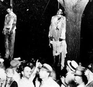
Two African-American men were lynched in Marion on August 7, 1930. A large, mostly white mob estimated at 5,000 gathered at the county jail where three young black men were held on charges of killing a white man and raping his girlfriend. Before they could be tried, the three, Thomas Shipp, Abram Smith, and James Cameron, were dragged from the jail and severely beaten. Shipp and Smith were hanged to death. Cameron was saved when an unidentified man said he had nothing to do with the crimes.
The woman retracted her accusation of rape. In 1931 Cameron was convicted as an accessory to murder and served four years before being paroled. He became educated and worked as a civil rights activist, later serving as the Indiana State Director of Civil Liberties from 1942 to 1950. He also founded three local chapters of the NAACP, and served as the first president of the Madison County, Indiana chapter. In 1988 he founded America’s Black Holocaust Museum in Milwaukee to preserve the history of African Americans who had faced the terror and violence of lynching. In 1993, James Cameron received an official apology and a full pardon from the state of Indiana.[11] Cameron later said, "Since the state of Indiana forgave me, I forgive the state of Indiana." In 2005, the U.S. Senate also officially apologized to Cameron and families of the victims of lynchings. The event in Marion was notable as the last confirmed lynching of blacks in Indiana and the Northern United States.[12]
Mid 20th-century industrial development
Marion's prosperity plateaued between the end of the gas boom, just prior to World War I, and 1955. But General Motors construction of a stamping and tool plant here created many new jobs. The city grew rapidly. Except for bedroom communities near metropolitan centers, Marion's growth during the 1950s exceeded all but one Indiana city with populations of 10,000-100,000.
Marion today
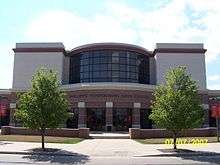
One of Marion's more notable architectural landmarks is the extensive Marion High School campus, which includes a 1,468-seat community auditorium. The Marion Philharmonic Orchestra, the Community School for the Arts, and the Mississinewa Valley Community Band perform here to provide musical and dramatic entertainment for Marion's numerous arts patrons. The city has a lending library, the Marion Public Library.[13]
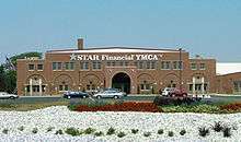
The eight-time state basketball champions, Marion Giants, play in the 7,500 seat Bill Green Athletic Arena. The city operates a 2.75-mile (4.43 km) Riverwalk from downtown to Matter Park, and there is a newly renovated $9,000,000 YMCA Memorial Coliseum to honor war veterans. This was the previous home of the Giants, which was built after their first State Basketball Title in 1926.
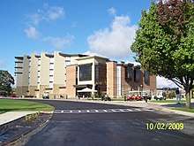
A publicly owned mansion, the Hostess House, is used for social functions, and Marion General Hospital has been nationally accredited for approximately a half-century. Marion General was recently named a magnet hospital. Fewer than 5% of all hospitals earn this honor.
Indiana Wesleyan University
With more than 15,000 students, Indiana Wesleyan University is the fastest-growing university in Indiana and currently the largest private university in the state. The university's main campus in Marion is home to more than 3,200 undergraduates and nearly 1,000 postgraduates. IWU has one of the largest adult education programs in the Midwest, and dozens of adult learning campuses are located throughout Indiana, Ohio, and Kentucky.
Indiana Wesleyan University's 345-acre (1.40 km2) Marion campus has won numerous architectural awards, and the university has spent nearly $250 million in the past 20 years on campus facilities. The university's award-winning, 1,200-seat, Phillippe Performing Arts Center is used for numerous community events throughout the year, such as Marion Philharmonic Orchestra concerts and the Grant County Spelling Bee.
Indiana Wesleyan's $22 million Chapel, which opened in January 2010, seats 3,800 and is one of the largest auditoriums in the Midwest. As one of the largest facilities of its kind in the nation, it was designed to attract major events to Marion, such as famous musical artists, renowned speakers, and national conventions. A few months after opening, the IWU Chapel was the site of a concert by the internationally recognized band, Switchfoot. The university is currently the largest single employer in the city of Marion and contributes over $1 million annually towards the local economy.
Economy
Marion's manufacturing sector produces automotive components, paper products, foundry products, machinery, wire, and cable. The paper plate industry was born in Marion; in its infancy, five of the nation's nine plants were located in the city.
The area surrounding Marion is part of the Corn Belt; as such, agriculture remains a significant component of the region's economy. Corn, soybean, and hog production are supplemented by specialty crops such as tomatoes.
Thomson SA's Marion facility was shuttered in 2004, leaving the city in an economic slump. On June 13, 2007, the Thomson building's northern portion was destroyed by a fire.[14] Other Marion plant closures in the past few decades include those of Ball-Foster, SCM (later Ampad) Paper Company, and the Malleable Iron Works (both on the far west side along Miller Avenue). The city has made inroads in attracting new businesses in the mid to late 2000s, however. Marion has been the only Midwest community selected as one of the Top 100 Micro-Enterprises for Economic Development by Site Selection Magazine for the years 2007 and 2008. TriEnda Plastics LLC selection of Marion in 2008 was one of the top 5 Manufacturing Projects in Indiana and received the coveted Silver Shovel award from Area Development Magazine. By spring 2011, TriEnda has ceased production. In the last ten years over $1,113,000 has been invested by private sector employers in Marion (source local newspaper).[15]
Christmas City U.S.A.
Christmas City U.S.A. is a local non-profit organization promoting the Christmas season in Marion and Grant County. It organizes and sponsors the Annual Christmas Parade each year the Saturday before Thanksgiving to kick off the Holiday season.
It all began in 1965 when the organization had a vision to expand the holiday season beyond the traditional cards and private parties. Directors wanted to foster human relations among residents of all ages and public relations toward nonresidents. In 1970, Christmas City and the Chamber of Commerce joined forces to promote a new look for the city. Postcards, bumper stickers, billboards were designed to establish the city as Christmas City U.S.A. The name was even trademarked to preserve the city's identity.[16] In 1991, Mayor Ron Mowery, Mark Erlewine, and a group of interested citizens decided to make Marion live up to its name. By combining the Mississinewa Riverwalk—the 2.25 mile walkway which is used year around for jogging, walking and more—and holiday lights and lighted displays, the Christmas City Walkway of Lights was established in 1992. The first year, the walkway was home to nearly 56,000 lights and lighted displays; the walkway has grown to include more than 2,000,000 lights and is nearly 4 miles long.[17]
Transportation
The Marion Municipal Airport is located three nautical miles (4 mi, 6 km) southwest of Marion's central business district.[18]
Notable people
- Jolly Blackburn, cartoonist, writer, creator of Knights of the Dinner Table
- Case Broderick, politician
- Chad Curtis, former professional baseball player
- Jim Davis, creator of Garfield, the lasagna-loving comic strip cat; (Davis's studio, Paws, Inc., is located near Muncie, Indiana)
- James Dean, iconic actor, born in Marion
- Willis Van Devanter, former Supreme Court Justice
- Mildred Dilling, harpist
- Jim Gallagher, Jr., professional golfer, golf analyst for USA Network
- Jeff King, former professional baseball player, Pittsburgh Pirates and Kansas City Royals
- Kenesaw Mountain Landis, first Commissioner of Baseball, practiced law in Marion
- Mike Melvill, the first commercial astronaut
- Keith O'Conner Murphy, Sweetser, IN, Rockabilly Hall of Fame,[19] singer-songwriter, Stacy and King Records (USA) [20] Polydor Records, England
- Stretch Murphy, Hall of Fame basketball player
- William N. Oatis, Associated Press correspondent detained 1951-1953 by Communist government of Czechoslovakia
- Joseph Price, professional basketball player NBA Washington Bullets. Current NCAA head basketball coach at Grambling State University
- Zach Randolph, professional basketball player, Sacramento Kings
- Wayne Seybold, former Marion mayor and pairs skater at 1988 Winter Olympics
- Caleb Blood Smith, Secretary of the Interior under President Abraham Lincoln and served as a prosecuting attorney in Marion
- George Washington Steele, Indiana Congressman and first governor of the Oklahoma Territory
- Monte Towe, North Carolina State Wolfpack National Champions 1974, Chicago Bulls, NCAA coach
- Jan Wiley, actress
See also
References
- ↑ "2016 U.S. Gazetteer Files". United States Census Bureau. Retrieved Jul 28, 2017.
- ↑ "US Board on Geographic Names". United States Geological Survey. 2007-10-25. Retrieved 2008-01-31.
- 1 2 "American FactFinder". United States Census Bureau. Retrieved 2012-12-11.
- 1 2 "Population and Housing Unit Estimates". Retrieved June 9, 2017.
- 1 2 "American FactFinder". United States Census Bureau. Archived from the original on 2013-09-11. Retrieved 2008-01-31.
- ↑ "Find a County". National Association of Counties. Archived from the original on 2015-05-10. Retrieved 2011-06-07.
- ↑ "State of Their Union". people.com. Retrieved 7 June 2015.
- ↑ "G001 - Geographic Identifiers - 2010 Census Summary File 1". United States Census Bureau. Retrieved 2015-07-29.
- ↑ "Mississinewa 1812". mississinewa1812.com. Retrieved 7 June 2015.
- ↑ National Park Service (2010-07-09). "National Register Information System". National Register of Historic Places. National Park Service.
- ↑ "James Cameron: Visionary Videos: NVLP: African American History". visionaryproject.org. Retrieved 7 June 2015.
- ↑ David Bradley, "Anatomy of a Murder", The Nation, June 12, 2006, p. 32-36.
- ↑ "Indiana public library directory" (PDF). Indiana State Library. Retrieved 7 March 2018.
- ↑ "Abandoned Marion properties are experiencing different fates - Indiana Economic Digest". indianaeconomicdigest.net. Retrieved 7 June 2015.
- ↑ "ECI Regional Center" (PDF). Uscis.gov. Retrieved 2016-08-11.
- ↑ "Archived copy". Archived from the original on 2006-12-02. Retrieved 2007-02-06.
- ↑ "Information". walkwayoflights.com. Retrieved 7 June 2015.
- ↑ FAA Airport Master Record for MZZ (Form 5010 PDF). Federal Aviation Administration. Effective 30 June 2011.
- ↑ "Keith O'Connor Murphy". Rockabillyhall.com. Retrieved 2013-04-30.
- ↑ "Landmark Series :: Outside the Classroom | The Rock and Roll Hall of Fame and Museum". Rockhall.com. Retrieved 2013-04-30.
| Wikimedia Commons has media related to Marion, Indiana. |
External links
| Wikisource has the text of the 1911 Encyclopædia Britannica article Marion (Indiana). |
Municipalities and communities of Grant County, Indiana, United States | ||
|---|---|---|
| Cities | ||
| Towns | ||
| Townships | ||
| CDPs | ||
| Unincorporated communities | ||
| Footnotes | ‡This populated place also has portions in an adjacent county or counties | |
