Knox, Indiana
| Knox, Indiana | |
|---|---|
| City | |
| City of Knox | |
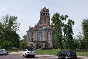 The Starke County Courthouse in Knox is listed on the National Register of Historic Places | |
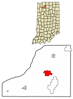 Location of Knox in Starke County, Indiana. | |
| Coordinates: 41°17′39″N 86°37′21″W / 41.29417°N 86.62250°WCoordinates: 41°17′39″N 86°37′21″W / 41.29417°N 86.62250°W | |
| Country | United States |
| State | Indiana |
| County | Starke |
| Township | Center |
| Government | |
| • Mayor | Dennis Estok (D) |
| Area[1] | |
| • Total | 3.92 sq mi (10.15 km2) |
| • Land | 3.92 sq mi (10.15 km2) |
| • Water | 0.00 sq mi (0.00 km2) |
| Elevation[2] | 712 ft (217 m) |
| Population (2010)[3] | |
| • Total | 3,704 |
| • Estimate (2016)[4] | 3,597 |
| • Density | 917.60/sq mi (354.26/km2) |
| Time zone | UTC-6 (CST) |
| • Summer (DST) | UTC-5 (CDT) |
| ZIP code | 46534 |
| Area code(s) | 574 Exchange: 772 |
| FIPS code | 18-40374[5] |
| GNIS feature ID | 437415 |
| Website | http://www.cityofknox.net |
Knox is a city in Center Township, Starke County, in the U.S. state of Indiana.[6] The population was 3,704 at the 2010 census. The city is the county seat of Starke County.[7]
History
.jpg)
Knox was founded in 1851, and is named after General Henry Knox.[8] The Knox post office has been in operation since 1820.[9]
Geography
Knox is located along the Yellow River.[10]
According to the 2010 census, Knox has a total area of 3.92 square miles (10.15 km2), all land.[11]
Demographics
| Historical population | |||
|---|---|---|---|
| Census | Pop. | %± | |
| 1860 | 124 | — | |
| 1870 | 244 | 96.8% | |
| 1880 | 316 | 29.5% | |
| 1890 | 790 | 150.0% | |
| 1900 | 1,466 | 85.6% | |
| 1910 | 1,644 | 12.1% | |
| 1920 | 1,577 | −4.1% | |
| 1930 | 1,815 | 15.1% | |
| 1940 | 2,165 | 19.3% | |
| 1950 | 3,034 | 40.1% | |
| 1960 | 3,458 | 14.0% | |
| 1970 | 3,519 | 1.8% | |
| 1980 | 3,674 | 4.4% | |
| 1990 | 3,705 | 0.8% | |
| 2000 | 3,721 | 0.4% | |
| 2010 | 3,704 | −0.5% | |
| Est. 2016 | 3,597 | [4] | −2.9% |
| U.S. Decennial Census[12] | |||
2010 census
As of the census[3] of 2010, there were 3,704 people, 1,457 households, and 975 families residing in the city. The population density was 944.9 inhabitants per square mile (364.8/km2). There were 1,633 housing units at an average density of 416.6 per square mile (160.9/km2). The racial makeup of the city was 96.3% White, 0.4% African American, 0.2% Native American, 0.3% Asian, 1.1% from other races, and 1.7% from two or more races. Hispanic or Latino of any race were 2.9% of the population.
There were 1,457 households of which 34.8% had children under the age of 18 living with them, 41.7% were married couples living together, 18.3% had a female householder with no husband present, 6.9% had a male householder with no wife present, and 33.1% were non-families. 27.9% of all households were made up of individuals and 13.6% had someone living alone who was 65 years of age or older. The average household size was 2.53 and the average family size was 3.03.
The median age in the city was 36.2 years. 26% of residents were under the age of 18; 10.1% were between the ages of 18 and 24; 24.5% were from 25 to 44; 25.8% were from 45 to 64; and 13.5% were 65 years of age or older. The gender makeup of the city was 46.3% male and 53.7% female.
2000 census
As of the census[5] of 2000, there were 3,721 people, 1,466 households, and 961 families residing in the city. The population density was 947.3 people per square mile (365.6/km²). There were 1,586 housing units at an average density of 403.8 per square mile (155.8/km²). The racial makeup of the city was 97.29% White, 0.11% African American, 0.24% Native American, 0.30% Asian, 0.03% Pacific Islander, 0.99% from other races, and 1.05% from two or more races. Hispanic or Latino of any race were 2.28% of the population.
There were 1,465 households out of which 31.2% had children under the age of 18 living with them, 46.8% were married couples living together, 14.3% had a female householder with no husband present, and 34.4% were non-families. 30.6% of all households were made up of individuals and 14.8% had someone living alone who was 65 years of age or older. The average household size was 2.43 and the average family size was 3.01.
In the city, the population was spread out with 25.6% under the age of 18, 8.2% from 18 to 24, 28.1% from 25 to 44, 20.5% from 45 to 64, and 17.6% who were 65 years of age or older. The median age was 37 years. For every 100 females, there were 90.4 males. For every 100 females age 18 and over, there were 87.7 males.
The median income for a household in the city was $29,891, and the median income for a family was $35,615. Males had a median income of $30,585 versus $20,994 for females. The per capita income for the city was $16,184. About 17.9% of families and 16.5% of the population were below the poverty line, including 24.9% of those under age 18 and 12.6% of those age 65 or over.
Education
The public school system of Knox consists of an Elementary (K-5th grade), Middle (6-8th grade), and High (9-12th) school. Knox's students are served by Knox Community Elementary School, Knox Community Middle SchoolKnox Community High School, located at 1 Redskin Trail and serving roughly 830 students from grades 9-12. The school's mascot is the Redskins.
Based on the 2009-10 school year, the Knox High School Student body consists of 51% males and 49% females, and a minority enrollment of 5%.[13]
Knox has a public library, a branch of the Starke County Public Library System.[14]
Notable people
- Henry F. Schricker, two-time Indiana Governor
Media
- WKVI 1520 AM and 99.3 FM. Locally owned by Kankakee Valley Broadcasting Company, serving the area since 1969.
In popular culture
The PBS Kids television series Postcards from Buster filmed the first episode here. Called "Meet Me At the Fair," Buster Baxter, the main character on the show, discovers what it is like to work on a farm.
Knox also features in the movie Bridegroom (film), a true story of a young man from Knox named Tom Bridegroom.[15]
24/7 Wall St.com reported on June 5, 2015 that Knox is the poorest town in Indiana. Just 5.5% of adults have a bachelor's degree or higher, compared to the statewide rate of 23.2% and the national rate of 28.8%. The town’s median household income of $30,300 was more than $75,000 less than the median household income of Indiana’s wealthiest town, Zionsville.[16]
References
- ↑ "2016 U.S. Gazetteer Files". United States Census Bureau. Retrieved Jul 28, 2017.
- ↑ "US Board on Geographic Names". United States Geological Survey. 2007-10-25. Retrieved 2008-01-31.
- 1 2 "American FactFinder". United States Census Bureau. Retrieved 2012-12-11.
- 1 2 "Population and Housing Unit Estimates". Retrieved June 9, 2017.
- 1 2 "American FactFinder". United States Census Bureau. Retrieved 2008-01-31.
- ↑ "Knox, Indiana". Geographic Names Information System. United States Geological Survey. Retrieved 2016-10-11.
- ↑ "Find a County". National Association of Counties. Archived from the original on 2011-05-31. Retrieved 2011-06-07.
- ↑ Baker, Ronald L.; Marvin Carmony (1995). Indiana Place Names. Bloomington: Indiana University Press. p. 83. ISBN 0-253-28340-X.
- ↑ "Starke County". Jim Forte Postal History. Retrieved October 11, 2016.
- ↑ Indiana Atlas & Gazetteer. Yarmouth, Me.: DeLorme. 1998. p. 20. ISBN 0-89933-211-0.
- ↑ "G001 - Geographic Identifiers - 2010 Census Summary File 1". United States Census Bureau. Retrieved 2015-07-28.
- ↑ "Census of Population and Housing". Census.gov. Archived from the original on May 12, 2015. Retrieved June 4, 2015.
- ↑ "Knox Community High School Overview". U.S. News and World Report. Retrieved 18 March 2013.
- ↑ "Hours & Locations". Starke County Public Library System. Retrieved 15 March 2018.
- ↑ Bridegroom, 2012, ""Archived copy". Archived from the original on 2012-12-17. Retrieved 2012-12-17. "
- ↑ ""
External links
- City website
- Knox, Indiana at Curlie (based on DMOZ)
Municipalities and communities of Starke County, Indiana, United States | ||
|---|---|---|
| City | ||
| Towns | ||
| Townships | ||
| CDPs | ||
| Other unincorporated communities | ||
| Footnotes | ‡This populated place also has portions in an adjacent county or counties | |