Monroe County, Indiana
| Monroe County, Indiana | ||
|---|---|---|
| County | ||
| Monroe County | ||
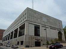
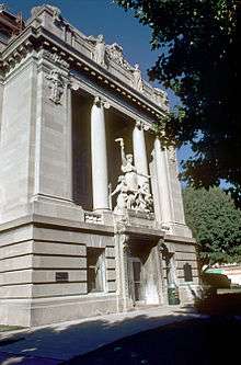 Monroe County courthouse in Bloomington, Indiana | ||
| ||
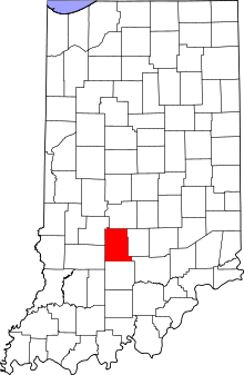 Location in the U.S. state of Indiana | ||
 Indiana's location in the U.S. | ||
| Founded | 1818 | |
| Named for | James Monroe | |
| Seat | Bloomington | |
| Largest city | Bloomington | |
| Area | ||
| • Total | 411.32 sq mi (1,065 km2) | |
| • Land | 394.51 sq mi (1,022 km2) | |
| • Water | 16.81 sq mi (44 km2), 4.09% | |
| Population (est.) | ||
| • (2017) | 146,986 | |
| • Density | 372.6/sq mi (143.9/km2) | |
| Congressional district | 9th | |
| Time zone | Eastern: UTC−5/−4 | |
| Website |
www | |
|
Footnotes: Indiana county number 53 | ||

Monroe County is a county located in the U.S. state of Indiana, and determined by the U.S. Census Bureau to include the mean center of U.S. population.[1] The population was 137,974 at the 2010 census.[2] The county seat is Bloomington.[3]
Monroe County is part of the Bloomington, Indiana, Metropolitan Statistical Area.
History
Monroe County was formed in 1818 from portions of Orange County. It was named for James Monroe,[4] fifth President of the United States, who was serving at the time the county was organized.
Geography
According to the 2010 census, the county has a total area of 411.32 square miles (1,065.3 km2), of which 394.51 square miles (1,021.8 km2) (or 95.91%) is land and 16.81 square miles (43.5 km2) (or 4.09%) is water.[5]
Bodies of water
Monroe County is divided between the basins of the East Fork and West Fork of Indiana's White River.[6] The northern part drains to the West Fork; the southern part of the county drains to the East Fork, primarily via the Salt Creek and its tributaries, such as the Clear Creek (known as the "Jordan River" on Indiana University Bloomington campus).
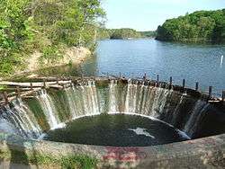
Several artificial reservoirs have been constructed by damming the county's creeks. The largest of them is Lake Monroe, a large reservoir on the Salt Creek in the south-eastern part of the county. It is used both for recreational purposes and to supply the city with drinking water.[6] Until the late 1960s, the main source of water supply was the smaller Lake Lemon (constructed 1953), in the northeastern part of the county; now it is the backup water source, and is mainly used for recreation.[7]
The third largest is Griffy Lake, on the northern slope of the county. Constructed in 1924 by damming Griffy Creek, it was Bloomington's main water source until 1954; it is now used primarily recreationally, although there are arrangements for it to be used as an emergency water source as well.[6][8][9] In 2012-2013, the lake was drained, the dam repaired, and then the lake was refilled again.
An even smaller Weimer (Wapehani) Lake in the Clear Creek basin was originally constructed for water supply purposes as well, but during most of its history was used purely for recreation (fishing).[10] In 2017, plans were announced to drain this lake permanently, as the authorities considered the dam unsafe.[11] This was carried out in the summer of 2018.
Limestone has been quarried in Monroe County since 1826.[12] A number of abandoned limestone quarries in the county are now cliff-surrounded lakes (seen in the 1979 film Breaking Away), stable without ongoing human intervention.
National protected areas
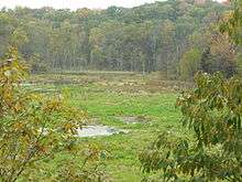
- Hoosier National Forest (part)
Natural wonders
- Buckner Cave
- Leonard Springs Nature Park, where the waters of Sinking Creek reappears in springs[13]
Communities
Cities
Towns
Census-designated places
Other unincorporated places
- Arlington
- Broadview
- Buenavista
- Cascade
- Chapel Hill
- Clear Creek
- Dolan
- Eastern Heights
- Elwren
- Fairfax
- Fleener
- Forest Park Heights
- Garden Acres
- Handy
- Highland Village
- Hindustan
- Hoosier Acres
- Hunter Switch
- Kirby
- Kirksville
- Knight Ridge
- Lancaster Park
- Leonard Springs
- Marlin Hills
- Modesto
- Mount Tabor
- New Unionville
- Ridgemede
- Sanders
- Smithville
- Stanford
- Sunny Slopes
- Unionville
- Van Buren Park
- Victor
- Wayport
- West Brook Downs
- Woodville Hills
- Yellowstone
Townships
Climate and weather
| Bloomington, Indiana | ||||||||||||||||||||||||||||||||||||||||||||||||||||||||||||
|---|---|---|---|---|---|---|---|---|---|---|---|---|---|---|---|---|---|---|---|---|---|---|---|---|---|---|---|---|---|---|---|---|---|---|---|---|---|---|---|---|---|---|---|---|---|---|---|---|---|---|---|---|---|---|---|---|---|---|---|---|
| Climate chart (explanation) | ||||||||||||||||||||||||||||||||||||||||||||||||||||||||||||
| ||||||||||||||||||||||||||||||||||||||||||||||||||||||||||||
| ||||||||||||||||||||||||||||||||||||||||||||||||||||||||||||
In recent years, average temperatures in Bloomington have ranged from a low of 19 °F (−7 °C) in January to a high of 86 °F (30 °C) in July, although a record low of −21 °F (−29 °C) was recorded in January 1985 and a record high of 110 °F (43 °C) was recorded in July 1936. Average monthly precipitation ranged from 2.66 inches (68 mm) in January to 5.12 inches (130 mm) in May.[14]
Government and politics
The county government is a constitutional body, and is granted specific powers by the Constitution of Indiana, and by the Indiana Code.
County Council: The county council is the fiscal body of the county government and controls all the spending and revenue collection in the county. There are four elected members representing districts and three members elected at-large. The council members serve four-year terms. They are responsible for setting salaries, the annual budget, and special spending. The council also has limited authority to impose local taxes, in the form of an income and property tax that is subject to state level approval, excise taxes, and service taxes.[15][16]
Board of Commissioners: The executive and legislative body of the county is made of a three-member board of commissioners. The commissioners are elected county-wide, in staggered terms, and each serves a four-year term. The president of the board of commissioners is the principle executive officer of the county. The commissioners are charged with setting policy and managing the day-to-day functions of the county government.[15][16]
Court: The county maintains a unified circuit court with nine divisions and a court commissioner that handles civil cases. Judges are elected to a term of six years and must be a member of the Indiana Bar Association. In some cases, court decisions can be appealed to the state level (appeals court, state supreme court).
County Officials: The county has several other elected offices, including sheriff, coroner, auditor, treasurer, recorder, surveyor, assessor, and circuit court clerk Each of these elected officers serves a term of four years and oversees a different part of county government. Members elected to county government positions are required to declare party affiliations and to be residents of the county.[16]
Monroe County is part of Indiana's 9th congressional district and is represented in Congress Republican Trey Hollingsworth.[17] It is part of Indiana Senate districts 37, 40 and 44;[18] and Indiana House of Representatives districts 46, 60 and 61.[19]
Courthouse
The Monroe County Courthouse is the seat of government for Monroe County and is the traditional center of Bloomington. The third courthouse to stand on the Downtown Square, the current courthouse was built in 1907 during a time of great prosperity. Wing & Mahurin designed the building.[20]
Politics
Monroe County formerly leaned Republican, however in recent decades it has trended Democratic, voting for the Democratic nominee in 6 out of the last 7 presidential elections.
| Year | Republican | Democratic | Third parties |
|---|---|---|---|
| 2016 | 35.2% 20,592 | 58.5% 34,216 | 6.2% 3,646 |
| 2012 | 39.3% 22,481 | 58.4% 33,436 | 2.3% 1,306 |
| 2008 | 33.3% 21,118 | 65.4% 41,450 | 1.3% 819 |
| 2004 | 45.3% 22,834 | 53.4% 26,965 | 1.3% 668 |
| 2000 | 47.6% 19,147 | 43.6% 17,523 | 8.8% 3,550 |
| 1996 | 42.3% 16,744 | 46.8% 18,531 | 11.0% 4,334 |
| 1992 | 38.2% 16,661 | 45.2% 19,712 | 16.6% 7,214 |
| 1988 | 56.0% 20,756 | 42.8% 15,855 | 1.2% 427 |
| 1984 | 59.1% 21,772 | 40.0% 14,719 | 0.9% 335 |
| 1980 | 49.4% 18,233 | 36.1% 13,316 | 14.5% 5,345 |
| 1976 | 53.1% 18,938 | 46.5% 16,609 | 0.4% 148 |
| 1972 | 56.1% 19,953 | 42.8% 15,241 | 1.1% 402 |
| 1968 | 50.8% 13,752 | 39.8% 10,789 | 9.4% 2,539 |
| 1964 | 46.1% 10,309 | 53.3% 11,918 | 0.7% 145 |
| 1960 | 65.4% 14,513 | 34.0% 7,535 | 0.6% 136 |
| 1956 | 62.9% 13,223 | 36.8% 7,732 | 0.3% 60 |
| 1952 | 60.6% 12,072 | 38.9% 7,745 | 0.5% 108 |
| 1948 | 54.6% 9,579 | 42.1% 7,375 | 3.3% 578 |
| 1944 | 55.8% 8,993 | 42.2% 6,809 | 2.0% 323 |
| 1940 | 55.7% 10,311 | 43.9% 8,117 | 0.4% 71 |
| 1936 | 48.8% 8,842 | 50.9% 9,220 | 0.3% 48 |
| 1932 | 47.0% 7,759 | 51.4% 8,478 | 1.6% 260 |
| 1928 | 67.0% 8,883 | 32.6% 4,317 | 0.4% 59 |
| 1924 | 55.2% 6,247 | 41.5% 4,689 | 3.3% 376 |
| 1920 | 53.7% 5,633 | 45.3% 4,751 | 1.1% 116 |
| 1916 | 50.3% 3,033 | 46.4% 2,796 | 3.3% 200 |
| 1912 | 25.2% 1,388 | 43.5% 2,396 | 31.3% 1,727 |
| 1908 | 51.5% 3,051 | 46.9% 2,780 | 1.6% 95 |
| 1904 | 55.8% 3,042 | 41.9% 2,286 | 2.3% 123 |
| 1900 | 52.7% 2,788 | 45.3% 2,397 | 2.0% 107 |
| 1896 | 50.2% 2,510 | 48.4% 2,422 | 1.4% 68 |
| 1892 | 45.9% 2,017 | 44.1% 1,937 | 10.1% 442 |
| 1888 | 51.5% 2,054 | 45.5% 1,815 | 3.0% 119 |
Education
Monroe County Public Library operates branches at Bloomington and Ellettsville.[22]
Transportation
Major highways


Form many years Monroe County was one of the most populous counties in the USA which did not contain any US highways or Interstate highways. However, in December 2015 the I-69 extension was completed into the county and this distinction disappeared. The highway was further extended north into Morgan County on September 18, 2018
Railways
Although Monroe County has a rich railway history, currently the only railway within Monroe County is the Indiana Rail Road, whose mainline crosses the county from the north-east to the south-west, with a few branches to local industrial facilities.[23][24][25] There is no passenger service.
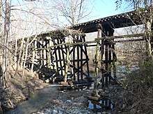
Between 1854 and 2004, an important north-south line connecting the Ohio River with Lake Michigan crossed Monroe County as well, serving Stinesville, Elletsville, Bloomington, Smithville, and Harrodsburg. It was operated by the Monon Railroad throughout much of the 20th century, and later by CSX. The last passenger service operating on this line was Amtrak's Floridian Chicago-Miami service, during 1972-1979. With the termination of this service in 1979, Monroe County forever lost passenger railway service. CSX continued to use this line for freight for another quarter of a century, but in 2004, it stopped using this line. Large parts of it have since been converted to trails. [12] [26]
Air transport
- Monroe County Airport, located a few miles southwest of Bloomington. Scheduled passenger service to this airport was terminated ca. 1997, and since then the airport has been used by general aviation only.
Demographics
| Historical population | |||
|---|---|---|---|
| Census | Pop. | %± | |
| 1820 | 2,679 | — | |
| 1830 | 6,577 | 145.5% | |
| 1840 | 10,143 | 54.2% | |
| 1850 | 11,286 | 11.3% | |
| 1860 | 12,847 | 13.8% | |
| 1870 | 14,168 | 10.3% | |
| 1880 | 15,875 | 12.0% | |
| 1890 | 17,673 | 11.3% | |
| 1900 | 20,873 | 18.1% | |
| 1910 | 23,426 | 12.2% | |
| 1920 | 24,519 | 4.7% | |
| 1930 | 35,974 | 46.7% | |
| 1940 | 36,534 | 1.6% | |
| 1950 | 50,080 | 37.1% | |
| 1960 | 59,225 | 18.3% | |
| 1970 | 84,849 | 43.3% | |
| 1980 | 98,785 | 16.4% | |
| 1990 | 108,978 | 10.3% | |
| 2000 | 120,563 | 10.6% | |
| 2010 | 137,974 | 14.4% | |
| Est. 2017 | 146,986 | [27] | 6.5% |
| U.S. Decennial Census[28] 1790–1960[29] 1900–1990[30] 1990–2000[31] 2010–2013[2] 2017[32] | |||
As of the 2010 United States Census, there were 137,974 people, 54,864 households, and 27,315 families residing in the county.[33] The population density was 349.7 inhabitants per square mile (135.0/km2). There were 59,107 housing units at an average density of 149.8 per square mile (57.8/km2).[5] The racial makeup of the county was 87.8% white, 5.2% Asian, 3.3% black or African American, 0.3% American Indian, 1.0% from other races, and 2.5% from two or more races. Those of Hispanic or Latino origin made up 2.9% of the population.[33] In terms of ancestry, 24.8% were German, 13.5% were Irish, 11.8% were English, and 8.1% were American.[34]
Of the 54,864 households, 22.7% had children under the age of 18 living with them, 38.2% were married couples living together, 8.1% had a female householder with no husband present, 50.2% were non-families, and 32.5% of all households were made up of individuals. The average household size was 2.24 and the average family size was 2.86. The median age was 27.7 years.[33]
The median income for a household in the county was $47,697 and the median income for a family was $60,845. Males had a median income of $43,439 versus $33,547 for females. The per capita income for the county was $21,882. About 10.6% of families and 25.5% of the population were below the poverty line, including 19.1% of those under age 18 and 8.2% of those age 65 or over.[35]
See also
References
- ↑ "Mean Center of Population for the United States: 1790 to 2000" (PDF). United States Census Bureau. Archived from the original (PDF) on November 3, 2001. Retrieved September 17, 2011.
- 1 2 "Monroe County QuickFacts". United States Census Bureau. Archived from the original on July 15, 2011. Retrieved September 25, 2011.
- ↑ "Find a County". National Association of Counties. Retrieved 2011-06-07.
- ↑ Gannett, Henry (1905). The Origin of Certain Place Names in the United States. U.S. Government Printing Office. p. 212.
- 1 2 "Population, Housing Units, Area, and Density: 2010 – County". United States Census Bureau. Retrieved 2015-07-10.
- 1 2 3 Water Basics: Stream Archived September 16, 2012, at the Wayback Machine. (City of Bloomington)
- ↑ Lake Lemon Conservancy District (LLCD)
- ↑ Griffy Lake Nature Preserve
- ↑ Abandoned Water Sanitation Station, Water Pump; Bloomington, IN Archived December 25, 2012, at Archive.is, "The Other Side of Indiana"
- ↑ City of Bloomington Environmental Resource Inventory (COBERI) Archived June 9, 2013, at the Wayback Machine., 2003–11
- ↑ City plans to remove most of dam, lake in Wapehani bike park
- 1 2 Limestone Industry TIMELINE
- ↑ Leonard Springs Nature Park Archived September 17, 2012, at the Wayback Machine.
- 1 2 "Monthly Averages for Bloomington, Indiana". The Weather Channel. Retrieved 2011-01-27.
- 1 2 Indiana Code. "Title 36, Article 2, Section 3". IN.gov. Retrieved 2008-09-16.
- 1 2 3 Indiana Code. "Title 2, Article 10, Section 2" (PDF). IN.gov. Retrieved 2008-09-16.
- ↑ (PDF). NationalAtlas.Gov http://nationalmap.gov/small_scale/printable/images/pdf/congdist/pagecgd113_in.pdf. Retrieved 2015-05-21. Missing or empty
|title=(help) - ↑ "Indiana Senate Districts". State of Indiana. Retrieved 2011-07-14.
- ↑ "Indiana House Districts". State of Indiana. Retrieved 2011-07-14.
- ↑ "Monroe County Courthouse – Bloomingpedia". www.bloomingpedia.org. Retrieved 2016-06-30.
- ↑ Leip, David. "Dave Leip's Atlas of U.S. Presidential Elections". uselectionatlas.org. Retrieved 2018-05-18.
- ↑ "Hours & Locations". Monroe County Public Library. Retrieved 10 March 2018.
- ↑ Indiana Railroad map
- ↑ State of Indiana 2012 railway system map (The branch to Elletsville, labeled "CSX", has been abandoned since)
- ↑ [https://www.in.gov/indot/files/Local%20Trax%20Rail%20Density.pdf Rail Density)
- ↑ Site Highlight: B-Line Trail in Bloomington
- ↑ "Population and Housing Unit Estimates". Retrieved June 9, 2017.
- ↑ "U.S. Decennial Census". United States Census Bureau. Retrieved July 10, 2014.
- ↑ "Historical Census Browser". University of Virginia Library. Retrieved July 10, 2014.
- ↑ "Population of Counties by Decennial Census: 1900 to 1990". United States Census Bureau. Retrieved July 10, 2014.
- ↑ "Census 2000 PHC-T-4. Ranking Tables for Counties: 1990 and 2000" (PDF). United States Census Bureau. Retrieved July 10, 2014.
- ↑ "QuickFacts. Monroe County, Indiana". United States Census Bureau. Retrieved October 11, 2018.
- 1 2 3 "DP-1 Profile of General Population and Housing Characteristics: 2010 Demographic Profile Data". United States Census Bureau. Retrieved 2015-07-10.
- ↑ "DP02 SELECTED SOCIAL CHARACTERISTICS IN THE UNITED STATES – 2006–2010 American Community Survey 5-Year Estimates". United States Census Bureau. Retrieved 2015-07-10.
- ↑ "DP03 SELECTED ECONOMIC CHARACTERISTICS – 2006–2010 American Community Survey 5-Year Estimates". United States Census Bureau. Retrieved 2015-07-10.
External links
Places adjacent to Monroe County, Indiana | ||||||||||
|---|---|---|---|---|---|---|---|---|---|---|
| ||||||||||
