Spencer, Indiana
| Spencer, Indiana | |
|---|---|
| Town | |
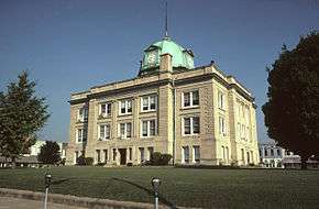 Owen County courthouse in Spencer | |
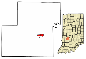 Location of Spencer in Owen County, Indiana. | |
| Coordinates: 39°17′13″N 86°45′51″W / 39.28694°N 86.76417°WCoordinates: 39°17′13″N 86°45′51″W / 39.28694°N 86.76417°W | |
| Country | United States |
| State | Indiana |
| County | Owen |
| Township | Washington |
| Area[1] | |
| • Total | 1.58 sq mi (4.10 km2) |
| • Land | 1.58 sq mi (4.10 km2) |
| • Water | 0.00 sq mi (0.00 km2) |
| Elevation[2] | 564 ft (172 m) |
| Population (2010)[3] | |
| • Total | 2,217 |
| • Estimate (2016)[4] | 2,271 |
| • Density | 1,432.81/sq mi (553.27/km2) |
| Time zone | UTC-5 (Eastern (EST)) |
| • Summer (DST) | UTC-4 (EDT) |
| ZIP code | 47460 |
| Area code(s) | 812 |
| FIPS code | 18-71972[5] |
| GNIS feature ID | 443934 |
| Website | http://www.spencer.in.gov/ |

Spencer is a town in Washington Township, Owen County, in the U.S. state of Indiana.[6] The population was 2,217 at the 2010 census. It is the county seat of Owen County.[7]
Spencer is part of the Bloomington, Indiana Metropolitan Statistical Area.
History
Spencer was platted in 1820, and named for Captain Spier Spencer, who fell at the Battle of Tippecanoe, after whom Spencer County is also named.[8] A post office has been in operation at Spencer since 1821.[9]
The Allison-Robinson House, David Enoch Beem House, Owen County Courthouse, Spencer Public Library, and Spencer Town Hall and Fire Station are listed on the National Register of Historic Places.[10]
Geography
According to the 2010 census, Spencer has a total area of 1.26 square miles (3.26 km2), all land.[11]
Climate
The climate in this area is characterized by hot, humid summers and generally mild to cool winters. According to the Köppen Climate Classification system, Spencer has a humid subtropical climate, abbreviated "Cfa" on climate maps.[12]
Demographics
| Historical population | |||
|---|---|---|---|
| Census | Pop. | %± | |
| 1850 | 335 | — | |
| 1870 | 971 | — | |
| 1880 | 1,655 | 70.4% | |
| 1890 | 1,868 | 12.9% | |
| 1900 | 2,026 | 8.5% | |
| 1910 | 2,150 | 6.1% | |
| 1920 | 2,066 | −3.9% | |
| 1930 | 2,179 | 5.5% | |
| 1940 | 2,375 | 9.0% | |
| 1950 | 2,394 | 0.8% | |
| 1960 | 2,557 | 6.8% | |
| 1970 | 2,553 | −0.2% | |
| 1980 | 2,732 | 7.0% | |
| 1990 | 2,609 | −4.5% | |
| 2000 | 2,508 | −3.9% | |
| 2010 | 2,217 | −11.6% | |
| Est. 2016 | 2,271 | [4] | 2.4% |
| U.S. Decennial Census[13] | |||
2010 census
As of the census[3] of 2010, there were 2,217 people, 1,008 households, and 554 families residing in the town. The population density was 1,759.5 inhabitants per square mile (679.3/km2). There were 1,123 housing units at an average density of 891.3 per square mile (344.1/km2). The racial makeup of the town was 98.1% White, 0.1% African American, 0.2% Native American, 0.5% Asian, 0.2% from other races, and 0.9% from two or more races. Hispanic or Latino of any race were 2.1% of the population.
There were 1,008 households of which 24.6% had children under the age of 18 living with them, 38.4% were married couples living together, 12.8% had a female householder with no husband present, 3.8% had a male householder with no wife present, and 45.0% were non-families. 40.1% of all households were made up of individuals and 18.4% had someone living alone who was 65 years of age or older. The average household size was 2.12 and the average family size was 2.81.
The median age in the town was 41.8 years. 20.1% of residents were under the age of 18; 9.4% were between the ages of 18 and 24; 24.2% were from 25 to 44; 26.3% were from 45 to 64; and 19.8% were 65 years of age or older. The gender makeup of the town was 47.2% male and 52.8% female.
2000 census
As of the census[5] of 2000, there were 2,508 people, 1,090 households, and 659 families residing in the town. The population density was 1,984.6 people per square mile (768.5/km²). There were 1,193 housing units at an average density of 944.0 per square mile (365.6/km²). The racial makeup of the town was 98.52% White, 0.20% African American, 0.40% Asian, 0.24% from other races, and 0.64% from two or more races. Hispanic or Latino of any race were 0.60% of the population.
There were 1,090 households out of which 27.2% had children under the age of 18 living with them, 45.1% were married couples living together, 12.8% had a female householder with no husband present, and 39.5% were non-families. 35.0% of all households were made up of individuals and 18.5% had someone living alone who was 65 years of age or older. The average household size was 2.23 and the average family size was 2.88.
In the town, the population was spread out with 23.0% under the age of 18, 10.1% from 18 to 24, 26.7% from 25 to 44, 20.3% from 45 to 64, and 20.0% who were 65 years of age or older. The median age was 39 years. For every 100 females, there were 83.2 males. For every 100 females age 18 and over, there were 81.9 males.
The median income for a household in the town was $28,664, and the median income for a family was $36,921. Males had a median income of $29,679 versus $21,531 for females. The per capita income for the town was $15,843. About 8.4% of families and 9.5% of the population were below the poverty line, including 13.2% of those under age 18 and 8.8% of those age 65 or over.
Education
Owen Valley Community High School (OVHS) is located in Spencer with 980 students and more than 100 faculty members. Built in 1971, OVHS is the result of a consolidation of several smaller schools located within Owen County. Owen Valley's mascot is the Patriot, and the school's colors are red, white and blue. The school's yearbook is the Triad, Tri- meaning the three schools that were merged to make Owen Valley High School.
The town has a lending library, the Owen County Public Library.[14]
Notable people
References
- ↑ "2016 U.S. Gazetteer Files". United States Census Bureau. Retrieved Jul 28, 2017.
- ↑ "US Board on Geographic Names". United States Geological Survey. 2007-10-25. Retrieved 2008-01-31.
- 1 2 "American FactFinder". United States Census Bureau. Retrieved 2012-12-11.
- 1 2 "Population and Housing Unit Estimates". Retrieved June 9, 2017.
- 1 2 "American FactFinder". United States Census Bureau. Retrieved 2008-01-31.
- ↑ "Spencer, Indiana". Geographic Names Information System. United States Geological Survey. Retrieved 2017-04-30.
- ↑ "Find a County". National Association of Counties. Retrieved 2011-06-07.
- ↑ Blanchard, Charles (1884). Counties of Clay and Owen, Indiana: Historical and Biographical. F.A. Battey & Company. p. 665.
- ↑ "Owen County". Jim Forte Postal History. Retrieved 21 September 2015.
- ↑ National Park Service (2010-07-09). "National Register Information System". National Register of Historic Places. National Park Service.
- ↑ "G001 - Geographic Identifiers - 2010 Census Summary File 1". United States Census Bureau. Retrieved 2015-07-25.
- ↑ Climate Summary for Spencer, Indiana
- ↑ "Census of Population and Housing". Census.gov. Retrieved June 4, 2015.
- ↑ "Indiana public library directory" (PDF). Indiana State Library. Retrieved 14 March 2018.
External links
| Wikimedia Commons has media related to Spencer, Indiana. |
Municipalities and communities of Owen County, Indiana, United States | ||
|---|---|---|
| Towns | ||
| Townships | ||
| Unincorporated communities |
| |
| Footnotes | ‡This populated place also has portions in an adjacent county or counties | |