Ohio County, Indiana
| Ohio County, Indiana | |
|---|---|
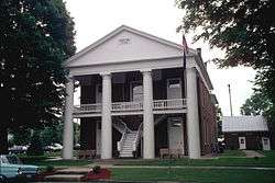 Ohio County Courthouse in Rising Sun | |
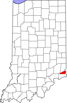 Location in the U.S. state of Indiana | |
 Indiana's location in the U.S. | |
| Founded | 1844 |
| Named for | Ohio River |
| Seat | Rising Sun |
| Largest city | Rising Sun |
| Area | |
| • Total | 87.43 sq mi (226 km2) |
| • Land | 86.14 sq mi (223 km2) |
| • Water | 1.29 sq mi (3 km2), 1.48% |
| Population | |
| • (2010) | 6,128 |
| • Density | 70.7/sq mi (27.28/km2) |
| Congressional district | 6th |
| Time zone | Eastern: UTC−5/−4 |
|
Footnotes: Indiana county number 58 FIPS County Code 115 Smallest county in Indiana in area Least populated county in Indiana | |
Ohio County is a county located in southeastern Indiana. As of 2010, the population was 6,128, making it Indiana's least populous county.[1] The county seat and only incorporated municipality is Rising Sun.[2][3] The county was officially established in 1844 and was one of the last Indiana counties to be created. It is the smallest county in the state in terms of both area and population.
Ohio County borders the state of Kentucky across the Ohio River for which it was named. It is part of the Cincinnati-Middletown, OH-KY-IN Metropolitan Statistical Area.
The county is divided into four townships which provide local services.[4][5] Three state roads pass through or into the county.[6]
History
Dearborn County was formed from Indiana Territory in 1803, and its borders were modified several times, both before and after the creation of the state of Indiana in 1816. Switzerland County was formed from part of Dearborn County in 1814. Ohio County also came out of Dearborn County, authorized by legislative action effective 4 January 1844.[7] It was named for the Ohio River, which defines its eastern border.[8]
The Ohio County courthouse was built in the county seat of Rising Sun in 1845. It is a two-story Greek Revival brick building measuring about 60 feet (18 m) by 40 feet (12 m), including the portico supported by Doric pillars.[9] This courthouse is still in use and is the oldest continuously-used courthouse in the state.[10]
Geography

According to the 2010 census, the county has a total area of 87.43 square miles (226.4 km2), of which 86.14 square miles (223.1 km2) (or 98.52%) is land and 1.29 square miles (3.3 km2) (or 1.48%) is water.[11]
Adjacent counties
- Boone County, Kentucky – east
- Dearborn County – north
- Ripley County – northwest
- Switzerland County – south
Communities
Incorporated communities
- Rising Sun – on the banks of the Ohio River
Unincorporated communities
Townships

Transportation
Highways
- US Route 50 in Dearborn County passes within 2 miles (3.2 km) of Ohio County's northern border.[12]
- State Road 56 enters from Switzerland County to the south and passes east along the southern border, then north through Rising Sun and along the river, continuing north to Dearborn county.[13]
- State Road 156 runs along the Ohio River in Switzerland County, and enters the far southeast part of Ohio County, continuing NW and north to its intersection with State Road 56, 1.5 miles inside Ohio County.[14]
- State Road 262 enters from Dillsboroand crosses the county in a general eastern direction, ending in Rising Sun.[15]
Railroads
There are no active railroad lines in the county.[16]
Education
Ohio County has two schools managed by a single school corporation.[17] The Ohio County Elementary–Middle School served a total of 636 students during the 2009–2010 school year.[18] Rising Sun High School served a total of 264 students during the same period.[19]
Ohio County residents are served by the Ohio County Public Library with a single branch in Rising Sun.[20]
Climate and weather
| Rising Sun, Indiana | ||||||||||||||||||||||||||||||||||||||||||||||||||||||||||||
|---|---|---|---|---|---|---|---|---|---|---|---|---|---|---|---|---|---|---|---|---|---|---|---|---|---|---|---|---|---|---|---|---|---|---|---|---|---|---|---|---|---|---|---|---|---|---|---|---|---|---|---|---|---|---|---|---|---|---|---|---|
| Climate chart (explanation) | ||||||||||||||||||||||||||||||||||||||||||||||||||||||||||||
| ||||||||||||||||||||||||||||||||||||||||||||||||||||||||||||
| ||||||||||||||||||||||||||||||||||||||||||||||||||||||||||||
In recent years, average temperatures in Rising Sun have ranged from a low of 21 °F (−6 °C) in January to a high of 87 °F (31 °C) in July, although a record low of −23 °F (−31 °C) was recorded in January 1994 and a record high of 104 °F (40 °C) was recorded in July 1988. Average monthly precipitation ranged from 2.92 inches (74 mm) in October to 4.83 inches (123 mm) in June.[21]
Government
The county government is a constitutional body granted specific powers by the Constitution of Indiana and the Indiana Code. The county council is the legislative branch of the county government and controls all spending and revenue collection. Representatives are elected from county districts. The council members serve four-year terms and are responsible for setting salaries, the annual budget and special spending. The council also has limited authority to impose local taxes, in the form of an income and property tax that is subject to state level approval, excise taxes and service taxes.[22][23]
A board of commissioners serves as the county's executive body. The commissioners are elected county–wide to staggered four–year terms. One commissioner serves as board president. The board executes the acts legislated by the council, collects revenue, and manages day-to-day functions of the county government.[22][23]
The county maintains a small claims court that can handle some civil cases. The judge on the court is elected to a term of four years and must be a member of the Indiana Bar Association. The judge is assisted by a constable who is elected to a four-year term. In some cases, court decisions can be appealed to the state level circuit court which is shared with neighboring Dearborn County.[23][24]
The county has several other elected offices, including sheriff, coroner, auditor, treasurer, recorder, surveyor and circuit court clerk; they are elected to four–year terms. Members elected to county government positions are required to declare party affiliations and be residents of the county.[23]
Each of the townships has a trustee who administers rural fire protection and ambulance service, provides poor relief and manages cemetery care, among other duties.[5] The trustee is assisted in these duties by a three-member township board. The trustees and board members are elected to four-year terms.[25]
Ohio County is part of Indiana's 9th congressional district; Indiana Senate district 43;[26] and Indiana House of Representatives district 68.[27]
| Year | Republican | Democratic | Third parties |
|---|---|---|---|
| 2016 | 72.5% 2,118 | 23.5% 686 | 4.0% 117 |
| 2012 | 62.4% 1,759 | 35.3% 994 | 2.3% 66 |
| 2008 | 58.7% 1,713 | 39.7% 1,158 | 1.6% 47 |
| 2004 | 60.7% 1,796 | 38.5% 1,139 | 0.8% 23 |
| 2000 | 60.8% 1,515 | 38.2% 951 | 1.0% 26 |
| 1996 | 44.4% 1,098 | 43.8% 1,083 | 11.9% 293 |
| 1992 | 40.1% 1,009 | 38.6% 970 | 21.3% 535 |
| 1988 | 55.8% 1,412 | 44.0% 1,113 | 0.2% 6 |
| 1984 | 58.3% 1,503 | 41.4% 1,068 | 0.2% 6 |
| 1980 | 52.2% 1,264 | 44.4% 1,074 | 3.4% 82 |
| 1976 | 44.0% 1,027 | 55.6% 1,300 | 0.4% 10 |
| 1972 | 59.5% 1,368 | 40.1% 922 | 0.4% 9 |
| 1968 | 46.0% 1,053 | 43.3% 991 | 10.6% 243 |
| 1964 | 39.2% 905 | 60.5% 1,397 | 0.3% 6 |
| 1960 | 56.3% 1,314 | 43.5% 1,015 | 0.3% 7 |
| 1956 | 53.1% 1,237 | 46.6% 1,087 | 0.3% 7 |
| 1952 | 51.9% 1,219 | 47.7% 1,119 | 0.4% 10 |
| 1948 | 46.6% 1,031 | 53.0% 1,173 | 0.5% 11 |
| 1944 | 51.6% 1,126 | 47.8% 1,043 | 0.7% 15 |
| 1940 | 49.3% 1,186 | 50.3% 1,210 | 0.3% 8 |
| 1936 | 42.9% 1,022 | 57.1% 1,362 | 0.0% 0 |
| 1932 | 43.3% 997 | 55.9% 1,288 | 0.9% 20 |
| 1928 | 57.1% 1,230 | 42.3% 911 | 0.6% 13 |
| 1924 | 47.0% 989 | 50.3% 1,058 | 2.8% 58 |
| 1920 | 50.9% 1,177 | 47.5% 1,097 | 1.6% 38 |
| 1916 | 47.5% 597 | 50.2% 632 | 2.3% 29 |
| 1912 | 36.0% 406 | 49.1% 553 | 14.9% 168 |
| 1908 | 49.1% 619 | 49.4% 622 | 1.5% 19 |
| 1904 | 60.7% 962 | 36.8% 584 | 2.5% 40 |
| 1900 | 53.3% 730 | 46.1% 632 | 0.7% 9 |
| 1896 | 52.6% 705 | 47.3% 634 | 0.1% 1 |
| 1892 | 51.7% 662 | 47.3% 606 | 0.9% 12 |
| 1888 | 55.3% 726 | 44.5% 585 | 0.2% 3 |
Demographics
| Historical population | |||
|---|---|---|---|
| Census | Pop. | %± | |
| 1850 | 5,308 | — | |
| 1860 | 5,462 | 2.9% | |
| 1870 | 5,837 | 6.9% | |
| 1880 | 5,563 | −4.7% | |
| 1890 | 4,955 | −10.9% | |
| 1900 | 4,724 | −4.7% | |
| 1910 | 4,329 | −8.4% | |
| 1920 | 4,024 | −7.0% | |
| 1930 | 3,747 | −6.9% | |
| 1940 | 3,782 | 0.9% | |
| 1950 | 4,223 | 11.7% | |
| 1960 | 4,165 | −1.4% | |
| 1970 | 4,289 | 3.0% | |
| 1980 | 5,114 | 19.2% | |
| 1990 | 5,315 | 3.9% | |
| 2000 | 5,623 | 5.8% | |
| 2010 | 6,128 | 9.0% | |
| Est. 2016 | 5,932 | [29] | −3.2% |
| U.S. Decennial Census[30] 1790-1960[31] 1900-1990[32] 1990-2000[33] 2010-2013[1] | |||
As of the 2010 United States Census, there were 6,128 people, 2,477 households, and 1,737 families residing in the county.[34] The population density was 71.1 inhabitants per square mile (27.5/km2). There were 2,784 housing units at an average density of 32.3 per square mile (12.5/km2).[11] The racial makeup of the county was 98.1% white, 0.4% black or African American, 0.3% Asian, 0.2% American Indian, 0.3% from other races, and 0.7% from two or more races. Those of Hispanic or Latino origin made up 1.1% of the population.[34] In terms of ancestry, 33.5% were German, 12.6% were Irish, 12.2% were American, and 7.3% were English.[35]
Of the 2,477 households, 28.7% had children under the age of 18 living with them, 56.2% were married couples living together, 9.8% had a female householder with no husband present, 29.9% were non-families, and 25.2% of all households were made up of individuals. The average household size was 2.45 and the average family size was 2.91. The median age was 43.7 years.[34]
The median income for a household in the county was $47,697 and the median income for a family was $64,271. Males had a median income of $49,241 versus $30,536 for females. The per capita income for the county was $25,703. About 5.5% of families and 8.4% of the population were below the poverty line, including 11.4% of those under age 18 and 8.6% of those age 65 or over.[36]
See also
References
- 1 2 "Ohio County QuickFacts". United States Census Bureau. Archived from the original on 15 July 2011. Retrieved 25 September 2011.
- ↑ "Find a County – Ohio County IN". National Association of Counties. Retrieved 3 December 2011.
- ↑ "Ohio County IN – County Subdivision and Place. GCT-PH1. Population, Housing Units, Area, and Density: 2000". US Census Bureau. Retrieved 9 February 2011.
- ↑ "Ohio". Indiana Township Association. Archived from the original on 1 June 2009. Retrieved 3 December 2011.
- 1 2 "Duties". United Township Association of Indiana. Retrieved 6 January 2011.
- ↑ "Indiana Transportation Map 2009–2010" (PDF). Indiana Dept. of Transportation. 2009. Retrieved 16 December 2010.
- ↑ History of Dearborn and Ohio Counties, Indiana 1885, p9. 111–9.
- ↑ Baker, Ronald L.; Carmony, Marvin (1975). Indiana Place Names. Bloomington IN: Indiana University Press. p. 121.
- ↑ History of Dearborn and Ohio Counties, Indiana 1885, pp. 123–124.
- ↑ Counts, Will; Jon Dilts (1991). The 92 Magnificent Indiana Courthouses. Bloomington IN: Indiana University Press. pp. 162–3. ISBN 978-0-253-33638-5.
- 1 2 "Population, Housing Units, Area, and Density: 2010 - County". US Census Bureau]]. Retrieved 10 July 2015.
- ↑ "US Route 50". Highway Explorer. Archived from the original on 12 October 2012. Retrieved 11 December 2011.
- ↑ "State Road 56". Highway Explorer. Archived from the original on 9 March 2012. Retrieved 11 December 2011.
- ↑ "State Road 156". Highway Explorer. Archived from the original on 6 April 2012. Retrieved 11 December 2011.
- ↑ "State Road 262". Highway Explorer. Archived from the original on 6 April 2012. Retrieved 11 December 2011.
- ↑ "State of Indiana 2011 Rail System Map" (PDF). Indiana Dept. of Transportation. 2011. Retrieved 19 June 2011.
- ↑ "Ohio County School Corporations". Indiana Department of Education. Retrieved 3 December 2011.
- ↑ "Ohio County Elem-Middle Sch - Overview". Indiana Department of Education. Retrieved 3 December 2011.
- ↑ "Rising Sun High School - Overview". Indiana Department of Education. Retrieved 3 December 2011.
- ↑ "Indiana public library directory" (PDF). Indiana State Library. Retrieved 14 March 2018.
- 1 2 "Monthly Averages for Rising Sun, Indiana". The Weather Channel. Retrieved 27 January 2011.
- 1 2 Indiana Code. "Title 36, Article 2, Section 3". Government of Indiana. Retrieved 16 September 2008.
- 1 2 3 4 Indiana Code. "Title 2, Article 10, Section 2" (PDF). Government of Indiana. Retrieved 16 September 2008.
- ↑ "Indiana Trial Courts: Types of Courts". Indiana Courts. Archived from the original on 19 October 2011. Retrieved 3 December 2011.
- ↑ "Government". United Township Association of Indiana. Retrieved 6 January 2011.
- ↑ "Indiana Senate Districts". State of Indiana. Retrieved 14 July 2011.
- ↑ "Indiana House Districts". State of Indiana. Retrieved 14 July 2011.
- ↑ Leip, David. "Dave Leip's Atlas of U.S. Presidential Elections". uselectionatlas.org. Retrieved 19 May 2018.
- ↑ "Population and Housing Unit Estimates". Retrieved 9 June 2017.
- ↑ "US Decennial Census". US Census Bureau. Archived from the original on 12 May 2015. Retrieved 10 July 2014.
- ↑ "Historical Census Browser". University of Virginia Library. Retrieved 10 July 2014.
- ↑ "Population of Counties by Decennial Census: 1900 to 1990". US Census Bureau. Retrieved 10 July 2014.
- ↑ "Census 2000 PHC-T-4. Ranking Tables for Counties: 1990 and 2000" (PDF). US Census Bureau. Retrieved 10 July 2014.
- 1 2 3 "Profile of General Population and Housing Characteristics: 2010 Demographic Profile Data". US Census Bureau. Retrieved 10 July 2015.
- ↑ "Selected Social Characteristics in the United States – 2006-2010 American Community Survey 5-Year Estimates". US Census Bureau. Retrieved 10 July 2015.
- ↑ "Selected Economic Characteristics – 2006-2010 American Community Survey 5-Year Estimates". US Census Bureau. Retrieved 10 July 2015.
External links
- Ohio County in Indiana State website
- History of Dearborn and Ohio Counties, Indiana. Chicago: Weakley Harraman & Co. 1885.

Places adjacent to Ohio County, Indiana | ||||||||||
|---|---|---|---|---|---|---|---|---|---|---|
| ||||||||||
Municipalities and communities of Ohio County, Indiana, United States | ||
|---|---|---|
| City | ||
| Townships | ||
| Unincorporated communities | ||
