Plymouth, Indiana
| City of Plymouth | |
|---|---|
| City | |
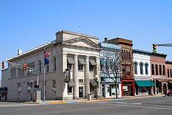 Downtown Plymouth | |
 Location of Plymouth in Marshall County, Indiana. | |
| Coordinates: 41°20′38″N 86°18′45″W / 41.34389°N 86.31250°WCoordinates: 41°20′38″N 86°18′45″W / 41.34389°N 86.31250°W | |
| Country | United States |
| State | Indiana |
| County | Marshall |
| Government | |
| • Mayor | Mark Senter (R) |
| Area[1] | |
| • Total | 7.57 sq mi (19.62 km2) |
| • Land | 7.53 sq mi (19.51 km2) |
| • Water | 0.04 sq mi (0.10 km2) 0.53% |
| Elevation | 797 ft (243 m) |
| Population (2010)[2] | |
| • Total | 10,033 |
| • Estimate (2016)[3] | 9,949 |
| • Density | 1,320.55/sq mi (509.88/km2) |
| Time zone | UTC-5 (EST) |
| • Summer (DST) | UTC-4 (EDT) |
| ZIP code | 46563 |
| Area code(s) | 574 |
| FIPS code | 18-60822[4] |
| GNIS feature ID | 0441379[5] |
| Website | http://www.plymouthin.com/ |
Plymouth is a city in Marshall County, Indiana, United States. The population 15,200 The city is the county seat of Marshall County.[6] Plymouth was the site of the first retail outlet of defunct U.S. retailer Montgomery Ward in 1926.
Geography
Plymouth, Indiana is located at 41°20′38″N 86°18′45″W / 41.34389°N 86.31250°W (41.343894, -86.312544),[7] along the Yellow River.[8]
According to the 2010 census, Plymouth has a total area of 7.57 square miles (19.61 km2), of which 7.53 square miles (19.50 km2) (or 99.47%) is land and 0.04 square miles (0.10 km2) (or 0.53%) is water.[9]

Demographics
| Historical population | |||
|---|---|---|---|
| Census | Pop. | %± | |
| 1860 | 1,277 | — | |
| 1870 | 2,482 | 94.4% | |
| 1880 | 2,570 | 3.5% | |
| 1890 | 2,728 | 6.1% | |
| 1900 | 3,656 | 34.0% | |
| 1910 | 3,838 | 5.0% | |
| 1920 | 4,338 | 13.0% | |
| 1930 | 5,290 | 21.9% | |
| 1940 | 5,713 | 8.0% | |
| 1950 | 6,704 | 17.3% | |
| 1960 | 7,558 | 12.7% | |
| 1970 | 7,661 | 1.4% | |
| 1980 | 7,693 | 0.4% | |
| 1990 | 8,303 | 7.9% | |
| 2000 | 9,840 | 18.5% | |
| 2010 | 10,033 | 2.0% | |
| Est. 2016 | 9,949 | [3] | −0.8% |
| U.S. Decennial Census[10] | |||
2010 census
As of the census[2] of 2010, there were 10,033 people, 3,940 households, and 2,401 families residing in the city. The population density was 1,332.4 inhabitants per square mile (514.4/km2). There were 4,451 housing units at an average density of 591.1 per square mile (228.2/km2). The racial makeup of the city was 87.2% White, 0.9% African American, 0.6% Native American, 0.5% Asian, 8.3% from other races, and 2.5% from two or more races. Hispanic or Latino of any race were 20.0% of the population.
There were 3,940 households of which 34.6% had children under the age of 18 living with them, 39.7% were married couples living together, 14.9% had a female householder with no husband present, 6.3% had a male householder with no wife present, and 39.1% were non-families. 33.5% of all households were made up of individuals and 15% had someone living alone who was 65 years of age or older. The average household size was 2.49 and the average family size was 3.19.
The median age in the city was 34.3 years. 27.9% of residents were under the age of 18; 9.3% were between the ages of 18 and 24; 25.9% were from 25 to 44; 21.9% were from 45 to 64; and 15.2% were 65 years of age or older. The gender makeup of the city was 47.9% male and 52.1% female.
2000 census
As of the census[4] of 2000, there were 9,840 people, 3,838 households, and 2,406 families residing in the city. The population density was 1,414.0 people per square mile (545.9/km²). There were 4,100 housing units at an average density of 589.2 per square mile (227.4/km²). The racial makeup of the city was 80.80% White, 0.63% African American, 0.45% Native American, 0.50% Asian, 6.19% from other races, and 1.43% from two or more races. Hispanic or Latino of any race were 14.99% of the population.
There were 3,838 households out of which 31.9% had children under the age of 18 living with them, 45.3% were married couples living together, 12.2% had a female householder with no husband present, and 37.3% were non-families. 31.4% of all households were made up of individuals and 14.4% had someone living alone who was 65 years of age or older. The average household size was 2.48 and the average family size was 3.11.
In the city, the population was spread out with 26.1% under the age of 18, 12.4% from 18 to 24, 28.8% from 25 to 44, 18.0% from 45 to 64, and 14.8% who were 65 years of age or older. The median age was 32 years. For every 100 females, there were 93.5 males. For every 100 females age 18 and over, there were 89.5 males.
The median income for a household in the city was $34,505, and the median income for a family was $41,447. Males had a median income of $30,444 versus $21,293 for females. The per capita income for the city was $15,417. About 10.4% of families and 13.1% of the population were below the poverty line, including 15.9% of those under age 18 and 9.6% of those age 65 or over.
History


This area was part of the territory of the Potawatomi Native Americans, one of the historical tribes encountered by European-American settlers. In the nineteenth century, the United States government made numerous treaties to buy and extinguish Native American claims to land in the former Northwest Territory and the Southeast.
Marshall County was formed in 1836, during the early years of settlement and before the forced removal of the Potawatomi people in 1838. It was named for U.S. Chief Justice John Marshall, who died in 1835.[11] Marshall County is notable as the starting point in 1838 of the Potawatomi Trail of Death, which was the forced removal by United States forces of Chief Menominee and 859 Potawatomi Indians from Indiana to Indian Territory, at the site of present-day Osawatomie, Kansas, a distance of 660 miles (1,060 km). The first settlers arrived in what is now Marshall County in 1835. They arrived as a result of the end of the Black Hawk War as well as the completion of the Erie Canal. They consisted primarily of settlers from New England, "Yankees" descended from the English Puritans who settled New England in the colonial era. They were mainly members of the Congregational Church, although due to the Second Great Awakening many of them had converted to Methodism and some had become Baptists before coming to what is now Marshall County. As a result of this heritage, some place names in Marshall County are named after places in New England, such as Plymouth, which is named after Plymouth, Massachusetts, the site where the Mayflower landed in 1620.[12] When these settlers arrived, there was nothing but a dense virgin forest and wild marshland, which would need to be cleared and drained before it could be farmed. The Indian Removal Act of 1830 authorized forcible removal if necessary. The United States government purchased this area under the Treaty of Tippecanoe in 1832.
Although many Potawatomi had relocated to Indian Territory in present-day Kansas, Chief Menominee and his band of the Yellow River refused to go. Militia under the authority of United States Army officers rounded them up and in September 1838, the band of 859 headed west, in what became known as the Potawatomi Trail of Death. They traveled more than 660 miles to Osawatomie, Kansas, with many of the Potawatomi walking. More than 40 of the tribal members died on the march.[13]
Plymouth was incorporated as a town in 1851.[14]
During the Civil War, Union Army soldiers arrested Daniel E. VanValkenburgh, editor of the Plymouth Weekly Democrat, who criticized what he viewed as Lincoln’s abuses of power. VanValkenburgh also criticized Department of Ohio commander Ambrose Burnside’s lieutenant, General Milo S. Hascall. Hascall was in charge of the District of Indiana. VanValkenburgh called Hascall a donkey in the pages of the Democrat. Hascall promptly dispatched soldiers to arrest VanValkenburgh and brought him before Burnside to answer charges of violating Burnside's General Order No. 38. Burnside let VanValkenburgh off with a warning. The Democrat became the first of eleven Democratic newspapers suppressed or threatened with suppression in May 1863.[15]
Much of Plymouth's history was documented in two major newspapers during the 19th century. The Marshall County Republican (also titled Plymouth Republican and Plymouth Tribune) operated from 1856 to 1922.[16] Its main rival the Marshall County Democrat (also titled Plymouth Democrat) appeared from 1855 to 1932 (and as a weekly only edition until January 1, 1941).[17] During the 20th century, the Plymouth Daily Pilot acquired the Republican in 1922, and the Democrat became the Plymouth Daily News in 1932. The News and Pilot merged to become the Plymouth Pilot-News in 1947.
As part of Plymouth's sesquicentennial celebration in 1966, organizers created the first Marshall County Blueberry Festival, to take place over Labor Day weekend. This tradition has continued annually, and the Festival typically brings in tens of thousands of visitors over the 4-day event.[18]
In July 1982, five firefighters were killed when their fire truck overturned while responding to a call. The tanker truck crashed on a curve near West School on state road 17.
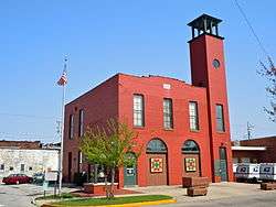
The East Laporte Street Footbridge, Heminger Travel Lodge, Marshall County Courthouse, Plymouth Downtown Historic District, Plymouth Northside Historic District, Plymouth Southside Historic District, and Plymouth Fire Station are listed on the National Register of Historic Places.[19][20][21]
Economy
As the center of commerce for Marshall County, Plymouth provides a large percentage of jobs in the manufacturing, retail, and service sectors. Major manufacturing employers include Hoosier Racing Tire, Zentis, Pregis Innovative Packaging, and the Maax Corporation. Six U. S. manufacturing headquarters are located in Plymouth: American Containers, Inc., Arrow Services, Inc., Auto Park, U.S. Granules Corp., Wiers Manufacturing, Inc. and Zentis North America, LLC.[22]
Parks and Recreation
Plymouth has nine parks. Centennial Park is the largest, with a swimming pool, lighted baseball and softball diamonds, lighted basketball courts, lighted tennis courts, shuffleboard, horseshoes, a skate park, and multiple playgrounds, including a large wooden castle playground and a smaller metal playground with swings and a climbing wall. The Athletic Department of Plymouth High School maintains the athletic fields for the park. Centennial Park also includes a dog park and a 2.7 mile long Greenway Trail that connects several parks.[23]
Each year over Labor Day weekend, Centennial Park is host to the town's Blueberry Festival. The Blueberry Festival is Indiana's largest four-day festival and has been named a "Top 100 Event" in North American by the American Bus Association three times. Over 300 craft vendors and 100 food vendors from all across the United States showcase their goods. The festival also includes the Hoosier Old Wheels Antique Car Show, the Blueberry Stomp 5K/15K run, Bicycle Cruise, hot air balloon launches, a parade, and fireworks display. There are several sporting events, and three stages with free entertainment for festival goers. For a small fee, festival goers can play carnival games and ride carnival rides.[24]
Packard's Wood Park also has athletic facilities and offers an all-inclusive play center called Freedom Park. River Park Square is located downtown and is home to Plymouth's Saturday Farmer's Market, a stage, and a splash pad. Magnetic Park contains a playground, a fishing pond, and a gazebo with a fountain as well as the Conservation Clubhouse, which is able to be rented out for events. Other parks include Gill Park, Hand Park, Founder's Park, Poplar Street Park, and Price's Memorial Park.[25]
Public library
The town has a lending library, the Plymouth Public Library.[26]
Awards
Plymouth ranks #4 on the Niche "Best Towns to Raise a Family in Indiana" list and #94 on the "Best Towns to Raise a Family in America" list.[27]
Plymouth was ranked #8 in the "Top 10 Safest Midsize Cities in Indiana" according to ValuePenguin.[28]
Notable residents
- Harry Short, Texas League baseball player
- Clifford L. Linedecker, author
- Danny Dean, FCA Employee
References
- ↑ "2016 U.S. Gazetteer Files". United States Census Bureau. Retrieved Jul 28, 2017.
- 1 2 "American FactFinder". United States Census Bureau. Retrieved 2012-12-11.
- 1 2 "Population and Housing Unit Estimates". Retrieved June 9, 2017.
- 1 2 "American FactFinder". United States Census Bureau. Retrieved 2008-01-31.
- ↑ "US Board on Geographic Names". United States Geological Survey. 2007-10-25. Retrieved 2008-01-31.
- ↑ "Find a County". National Association of Counties. Retrieved 2011-06-07.
- ↑ "US Gazetteer files: 2010, 2000, and 1990". United States Census Bureau. 2011-02-12. Retrieved 2011-04-23.
- ↑ Indiana Atlas & Gazetteer. Yarmouth, Me.: DeLorme. 1998. p. 20. ISBN 0-89933-211-0.
- ↑ "G001 - Geographic Identifiers - 2010 Census Summary File 1". United States Census Bureau. Retrieved 2015-07-29.
- ↑ "Census of Population and Housing". Census.gov. Retrieved June 4, 2015.
- ↑ De Witt Clinton Goodrich & Charles Richard Tuttle (1875). An Illustrated History of the State of Indiana. Indiana: R. S. Peale & co. p. 567.
- ↑ A Twentieth Century History of Marshall County, Indiana, Volume 1 By Daniel McDonald
- ↑ Potawatomi Trail of Death Association
- ↑ McDonald, Daniel (1908). A Twentieth Century History of Marshall County, Indiana, Volume 1. Lewis Publishing Company. p. 105.
- ↑ "Killing the Serpent Speedily" Indiana Historic Newspaper Digitization Project blog
- ↑ A History of the Plymouth Republican
- ↑ Plymouth's Democrat newspaper from 1855-1870 digitized
- ↑ Marshall County Blueberry Festival History
- ↑ National Park Service (2010-07-09). "National Register Information System". National Register of Historic Places. National Park Service.
- ↑ "National Register of Historic Places Listings". Weekly List of Actions Taken on Properties: 9/16/13 through 9/30/13. National Park Service. 2013-10-18.
- ↑ "National Register of Historic Places Listings". Weekly List of Actions Taken on Properties: 12/30/13 through 1/03/14. National Park Service. 2014-01-10.
- ↑
- ↑ Plymouth Park and Recreation Department (PDF) http://www.plymouthin.com/files/2314/9997/9770/2017_Map-Brochure.pdf. Missing or empty
|title=(help) - ↑ "History". Blueberry Festival.
- ↑ Plymouth Park and Recreation Department (PDF) http://www.plymouthin.com/files/2314/9997/9770/2017_Map-Brochure.pdf. Missing or empty
|title=(help) - ↑ "Indiana public library directory" (PDF). Indiana State Library. Retrieved 10 March 2018.
- ↑
- ↑
External links
Municipalities and communities of Marshall County, Indiana, United States | ||
|---|---|---|
| City | ||
| Towns | ||
| Townships | ||
| CDP | ||
| Unincorporated communities | ||
| Footnotes | ‡This populated place also has portions in an adjacent county or counties | |