Owen County, Indiana
| Owen County, Indiana | |
|---|---|
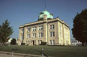 Owen County Courthouse in Spencer, Indiana | |
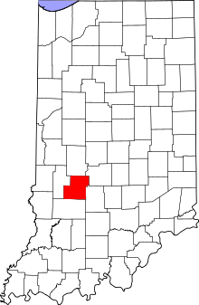 Location in the U.S. state of Indiana | |
 Indiana's location in the U.S. | |
| Founded | 1819 |
| Named for | Abraham Owen |
| Seat | Spencer |
| Largest town | Spencer |
| Area | |
| • Total | 387.82 sq mi (1,004 km2) |
| • Land | 385.29 sq mi (998 km2) |
| • Water | 2.54 sq mi (7 km2), 0.65% |
| Population | |
| • (2010) | 21,575 |
| • Density | 56/sq mi (21.63/km2) |
| Congressional district | 8th |
| Time zone | Eastern: UTC−5/−4 |
| Website | Owen County Official Website |
|
Footnotes: Indiana county number 60 | |
Owen County is a county located in the U.S. state of Indiana, and determined by the U.S. Census Bureau to include the mean center of U.S. population in 1920. As of 2010, the population was 21,575.[1] The county seat is Spencer.[2]
Owen County is part of the Bloomington, Indiana, Metropolitan Statistical Area.
Adjacent counties
- Putnam County (north)
- Morgan County (northeast)
- Monroe County (southeast)
- Greene County (south)
- Clay County (west)
Major highways
History
Owen County was formed in 1819. It was named after Abraham Owen, a colonel who died at the Battle of Tippecanoe.
In 1920, the United States Census reported Owen County as the Center of Population for the US at a point 8 miles south-southeast of Spencer, Indiana. The center moved the shortest distance since census data collecting began in 1790 (just under 10 miles) from its previous center in Bloomington, IN. When the East experienced high rates of growth, as it did in the decades between 1890 and 1920, the Westward movement of the center slowed.[3]
Climate and weather
| Spencer, Indiana | ||||||||||||||||||||||||||||||||||||||||||||||||||||||||||||
|---|---|---|---|---|---|---|---|---|---|---|---|---|---|---|---|---|---|---|---|---|---|---|---|---|---|---|---|---|---|---|---|---|---|---|---|---|---|---|---|---|---|---|---|---|---|---|---|---|---|---|---|---|---|---|---|---|---|---|---|---|
| Climate chart (explanation) | ||||||||||||||||||||||||||||||||||||||||||||||||||||||||||||
| ||||||||||||||||||||||||||||||||||||||||||||||||||||||||||||
| ||||||||||||||||||||||||||||||||||||||||||||||||||||||||||||
In recent years, average temperatures in Spencer have ranged from a low of 15 °F (−9 °C) in January to a high of 84 °F (29 °C) in July, although a record low of −33 °F (−36 °C) was recorded in January 1994 and a record high of 107 °F (42 °C) was recorded in July 1954. Average monthly precipitation ranged from 2.56 inches (65 mm) in January to 4.97 inches (126 mm) in May.[4]
Government
The county government is a constitutional body, and is granted specific powers by the Constitution of Indiana, and by the Indiana Code.
County Council: The county council is the fiscal body of the county government. It has seven members, three of which are elected county-wide (commonly referred to at-large members) and four of which are elected from districts. District One includes Harrison, Montgomery, Taylor, and Wayne Townships including the Town of Gosport. District Two includes Washington Township including the Town of Spencer. District Three includes Jackson, Jennings, Lafayette, and Morgan Townships. District Four includes Clay, Franklin, Jefferson, and Marion Townships. All council members serve four-year terms with at-large members elected during Presidential election cycles and district members elected during the other election cycles. One of the council members serves as president and another as vice-president. The council is responsible for setting salaries, the annual budget, and special spending. The council also has limited authority to impose local taxes, in the form of an income and property tax that is subject to state level approval, excise taxes, and service taxes. Several local boards such as the Alcoholic Beverage Board and Library Board have a member or members appointed by the council.[5][6][7]
Board of Commissioners: The executive body of the county is made of a board of commissioners with three members. The commissioners are elected county-wide, however each must reside in their respective districts, two of which are elected during Presidential election cycles and the other during the other election cycles. Each serves a four-year term. The District One member must reside in Harrison, Jackson, Jennings, Montgomery, Taylor, or Wayne Townships. The District Two member must reside in Clay, Franklin, or Washington Townships. The District Three member must reside in Jefferson, Lafayette, Marion, or Morgan Townships. One of the commissioners serves as president and another as vice-president. The commissioners are charged with executing the acts legislated by the council, collecting revenue, and managing the day-to-day functions of the county government.[5][6][8]
Court: The county has a Circuit Court. The judge on the court is elected to a term of six years and must be a member of the Indiana Bar Association.[6][9]
County Officials: The county has several other elected offices, including sheriff, coroner, prosecutor, assessor, auditor, treasurer, recorder, surveyor and clerk of the circuit court. Each of these elected officers serves a term of four years and oversees a different part of county government. Members elected to county government positions are required to declare party affiliations and to be residents of the county.[6]
| Year | Republican | Democratic | Third parties |
|---|---|---|---|
| 2016 | 71.9% 6,153 | 22.7% 1,946 | 5.4% 458 |
| 2012 | 62.4% 5,062 | 34.8% 2,823 | 2.8% 228 |
| 2008 | 54.0% 4,415 | 43.7% 3,570 | 2.3% 185 |
| 2004 | 65.8% 5,000 | 33.4% 2,536 | 0.9% 68 |
| 2000 | 61.8% 4,019 | 34.7% 2,253 | 3.6% 231 |
| 1996 | 48.8% 3,056 | 35.8% 2,244 | 15.4% 966 |
| 1992 | 42.0% 2,753 | 33.7% 2,207 | 24.3% 1,595 |
| 1988 | 60.3% 3,837 | 39.0% 2,484 | 0.7% 42 |
| 1984 | 66.5% 4,204 | 32.9% 2,082 | 0.6% 37 |
| 1980 | 58.5% 3,632 | 37.4% 2,325 | 4.1% 255 |
| 1976 | 47.8% 2,896 | 51.3% 3,103 | 0.9% 56 |
| 1972 | 69.3% 3,896 | 30.4% 1,708 | 0.4% 22 |
| 1968 | 51.6% 2,898 | 34.4% 1,932 | 14.0% 788 |
| 1964 | 45.3% 2,788 | 54.2% 3,339 | 0.5% 33 |
| 1960 | 60.4% 3,700 | 38.8% 2,379 | 0.8% 49 |
| 1956 | 58.5% 3,685 | 41.0% 2,581 | 0.6% 35 |
| 1952 | 58.4% 3,713 | 40.5% 2,577 | 1.1% 71 |
| 1948 | 51.1% 3,002 | 46.6% 2,738 | 2.2% 130 |
| 1944 | 55.5% 3,318 | 43.6% 2,602 | 0.9% 55 |
| 1940 | 54.0% 3,709 | 45.4% 3,121 | 0.6% 38 |
| 1936 | 46.5% 3,091 | 52.6% 3,498 | 0.9% 59 |
| 1932 | 38.9% 2,423 | 58.4% 3,639 | 2.8% 174 |
| 1928 | 55.0% 3,036 | 43.9% 2,420 | 1.1% 61 |
| 1924 | 47.4% 2,627 | 48.2% 2,670 | 4.4% 244 |
| 1920 | 49.2% 2,997 | 48.4% 2,948 | 2.5% 149 |
| 1916 | 44.7% 1,585 | 51.1% 1,812 | 4.3% 151 |
| 1912 | 21.2% 711 | 48.3% 1,621 | 30.5% 1,023 |
| 1908 | 44.5% 1,726 | 52.2% 2,023 | 3.3% 127 |
| 1904 | 46.3% 1,721 | 49.5% 1,841 | 4.2% 158 |
| 1900 | 44.3% 1,706 | 53.4% 2,057 | 2.3% 90 |
| 1896 | 45.5% 1,751 | 53.7% 2,070 | 0.8% 32 |
| 1892 | 43.5% 1,569 | 48.2% 1,738 | 8.3% 299 |
| 1888 | 45.1% 1,632 | 53.0% 1,918 | 1.9% 70 |
Demographics
| Historical population | |||
|---|---|---|---|
| Census | Pop. | %± | |
| 1820 | 838 | — | |
| 1830 | 4,017 | 379.4% | |
| 1840 | 8,359 | 108.1% | |
| 1850 | 12,106 | 44.8% | |
| 1860 | 14,376 | 18.8% | |
| 1870 | 16,137 | 12.2% | |
| 1880 | 15,901 | −1.5% | |
| 1890 | 15,040 | −5.4% | |
| 1900 | 15,149 | 0.7% | |
| 1910 | 14,053 | −7.2% | |
| 1920 | 12,760 | −9.2% | |
| 1930 | 11,351 | −11.0% | |
| 1940 | 12,090 | 6.5% | |
| 1950 | 11,763 | −2.7% | |
| 1960 | 11,400 | −3.1% | |
| 1970 | 12,163 | 6.7% | |
| 1980 | 15,841 | 30.2% | |
| 1990 | 17,281 | 9.1% | |
| 2000 | 21,786 | 26.1% | |
| 2010 | 21,575 | −1.0% | |
| Est. 2016 | 20,840 | [11] | −3.4% |
| U.S. Decennial Census[12] 1790-1960[13] 1900-1990[14] 1990-2000[15] 2010-2013[1] | |||
As of the 2010 United States Census, there were 21,575 people, 8,486 households, and 5,992 families residing in the county.[16] The population density was 56.0 inhabitants per square mile (21.6/km2). There were 10,091 housing units at an average density of 26.2 per square mile (10.1/km2).[17] The racial makeup of the county was 97.9% white, 0.3% Asian, 0.3% American Indian, 0.3% black or African American, 0.2% from other races, and 0.9% from two or more races. Those of Hispanic or Latino origin made up 0.9% of the population.[16] In terms of ancestry, 28.7% were German, 20.7% were Irish, 8.9% were English, and 8.4% were American.[18]
Of the 8,486 households, 31.0% had children under the age of 18 living with them, 56.1% were married couples living together, 9.2% had a female householder with no husband present, 29.4% were non-families, and 24.0% of all households were made up of individuals. The average household size was 2.52 and the average family size was 2.96. The median age was 42.4 years.[16]
The median income for a household in the county was $47,697 and the median income for a family was $52,343. Males had a median income of $40,668 versus $30,556 for females. The per capita income for the county was $20,581. About 9.2% of families and 12.4% of the population were below the poverty line, including 17.8% of those under age 18 and 8.1% of those age 65 or over.[19]
Cities and towns
Unincorporated towns
- Adel
- Alaska
- Arney
- Atkinsonville
- Beamer
- Braysville
- Carp
- Cataract
- Coal City
- Cuba
- Cunot
- Daggett
- Denmark
- Devore
- Farmers
- Freedom
- Freeman
- Hancock Corner
- Hickory Corner
- Highets Corner
- Hubbell
- Jordan
- Lewisville
- Marion Mills
- New Hope
- Patricksburg
- Pottersville
- Quincy
- Romona
- Silex
- Smithville
- Southport
- Stockton
- Vandalia
- Vilas
- Wallace Junction
- Whitehall
Townships
See also
References
- 1 2 "Owen County QuickFacts". United States Census Bureau. Archived from the original on 2011-07-16. Retrieved 2011-09-25.
- ↑ "Find a County". National Association of Counties. Retrieved 2011-06-07.
- ↑ United States Census Center of Population - 1920 "Archived copy". Archived from the original on 2011-09-02. Retrieved 2011-09-03.
- 1 2 "Monthly Averages for Spencer, Indiana". The Weather Channel. Retrieved 2011-01-27.
- 1 2 Indiana Code. "Title 36, Article 2, Section 3". IN.gov. Retrieved 2008-09-16.
- 1 2 3 4 Indiana Code. "Title 2, Article 10, Section 2" (PDF). IN.gov. Retrieved 2008-09-16.
- ↑ Owen County Government, Owen County Council, http://www.owencounty.in.gov/html/modules.php?name=Content&pa=showpage&pid=10
- ↑ Owen County Government, Owen County Commissioners, "Archived copy". Archived from the original on 2009-08-20. Retrieved 2009-08-23.
- ↑ Owen County Government, Circuit Court, "Archived copy". Archived from the original on 2009-08-20. Retrieved 2009-08-23.
- ↑ Leip, David. "Dave Leip's Atlas of U.S. Presidential Elections". uselectionatlas.org. Retrieved 10 April 2018.
- ↑ "Population and Housing Unit Estimates". Retrieved June 9, 2017.
- ↑ "U.S. Decennial Census". United States Census Bureau. Retrieved July 10, 2014.
- ↑ "Historical Census Browser". University of Virginia Library. Retrieved July 10, 2014.
- ↑ "Population of Counties by Decennial Census: 1900 to 1990". United States Census Bureau. Retrieved July 10, 2014.
- ↑ "Census 2000 PHC-T-4. Ranking Tables for Counties: 1990 and 2000" (PDF). United States Census Bureau. Retrieved July 10, 2014.
- 1 2 3 "DP-1 Profile of General Population and Housing Characteristics: 2010 Demographic Profile Data". United States Census Bureau. Retrieved 2015-07-10.
- ↑ "Population, Housing Units, Area, and Density: 2010 - County". United States Census Bureau. Retrieved 2015-07-10.
- ↑ "DP02 SELECTED SOCIAL CHARACTERISTICS IN THE UNITED STATES – 2006-2010 American Community Survey 5-Year Estimates". United States Census Bureau. Retrieved 2015-07-10.
- ↑ "DP03 SELECTED ECONOMIC CHARACTERISTICS – 2006-2010 American Community Survey 5-Year Estimates". United States Census Bureau. Retrieved 2015-07-10.
External links
Places adjacent to Owen County, Indiana | ||||||||||
|---|---|---|---|---|---|---|---|---|---|---|
| ||||||||||
Municipalities and communities of Owen County, Indiana, United States | ||
|---|---|---|
| Towns | ||
| Townships | ||
| Unincorporated communities |
| |
| Footnotes | ‡This populated place also has portions in an adjacent county or counties | |
