Scottsburg, Indiana
| Scottsburg, Indiana | |
|---|---|
| City | |
| City of Scottsburg | |
 | |
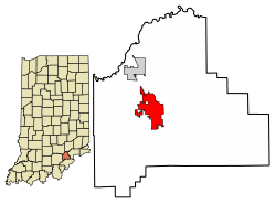 Location of Scottsburg in Scott County, Indiana. | |
| Coordinates: 38°41′7.3″N 85°46′10.55″W / 38.685361°N 85.7695972°WCoordinates: 38°41′7.3″N 85°46′10.55″W / 38.685361°N 85.7695972°W | |
| Country | United States |
| State | Indiana |
| County | Scott |
| Township | Vienna |
| Government | |
| • Mayor | William H. "Bill" Graham (R) |
| Area[1] | |
| • Total | 5.33 sq mi (13.80 km2) |
| • Land | 5.30 sq mi (13.74 km2) |
| • Water | 0.02 sq mi (0.06 km2) 0.39% |
| Elevation[2] | 564 ft (172 m) |
| Population (2010)[3] | |
| • Total | 6,747 |
| • Estimate (2016)[4] | 6,684 |
| • Density | 1,260.18/sq mi (486.59/km2) |
| Time zone | UTC-5 (EST) |
| • Summer (DST) | UTC-4 (EDT) |
| ZIP code | 47170 |
| Area code(s) | 812 |
| FIPS code | 18-68526[5] |
| GNIS feature ID | 443163 |
| Website | http://www.cityofscottsburg.com/ |
Scottsburg is a city in Vienna Township, Scott County, in the U.S. state of Indiana, about 30 miles (48 km) north of Louisville, Kentucky. The population was 6,747 at the 2010 census. The city is the county seat of Scott County.[6]
History
Scottsburg was platted in 1871.[7] The city was named for Horace Scott, a railroad official.[8] A post office has been in operation at Scottsburg since 1873.[9]
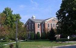
The Scott County Home, Scottsburg Courthouse Square Historic District, and Scottsburg Depot are listed on the National Register of Historic Places.[10]
Geography
Scottsburg is located at 38°41′7.3″N 85°46′10.55″W / 38.685361°N 85.7695972°W (38.685361, -85.769597).[11]
According to the 2010 census, Scottsburg has a total area of 5.069 square miles (13.13 km2), of which 5.05 square miles (13.08 km2) (or 99.63%) is land and 0.019 square miles (0.05 km2) (or 0.37%) is water.[12]
Climate
The climate in this area is characterized by hot, humid summers and cold mid-west winters. According to the Köppen Climate Classification system, Scottsburg has a humid subtropical climate, abbreviated "Cfa" on climate maps.[13]
| Climate data for Scottsburg | |||||||||||||
|---|---|---|---|---|---|---|---|---|---|---|---|---|---|
| Month | Jan | Feb | Mar | Apr | May | Jun | Jul | Aug | Sep | Oct | Nov | Dec | Year |
| Average high °C (°F) | 4 (39) |
6 (43) |
12 (54) |
19 (66) |
24 (75) |
29 (84) |
31 (88) |
30 (86) |
27 (81) |
21 (70) |
12 (54) |
6 (43) |
18 (64) |
| Daily mean °C (°F) | 0 (32) |
1 (34) |
6 (43) |
12 (54) |
17 (63) |
22 (72) |
24 (75) |
23 (73) |
20 (68) |
13 (55) |
6 (43) |
1 (34) |
12 (54) |
| Average low °C (°F) | −5 (23) |
−4 (25) |
0 (32) |
5 (41) |
11 (52) |
16 (61) |
18 (64) |
17 (63) |
13 (55) |
6 (43) |
0 (32) |
−3 (27) |
6 (43) |
| Average precipitation mm (inches) | 90 (3.54) |
72 (2.83) |
111 (4.37) |
104 (4.09) |
107 (4.21) |
106 (4.17) |
102 (4.02) |
95 (3.74) |
75 (2.95) |
72 (2.83) |
83 (3.27) |
83 (3.27) |
1,098 (43.23) |
| Source: [14] | |||||||||||||
Demographics
| Historical population | |||
|---|---|---|---|
| Census | Pop. | %± | |
| 1880 | 454 | — | |
| 1890 | 618 | 36.1% | |
| 1900 | 1,274 | 106.1% | |
| 1910 | 1,669 | 31.0% | |
| 1920 | 1,609 | −3.6% | |
| 1930 | 1,702 | 5.8% | |
| 1940 | 2,189 | 28.6% | |
| 1950 | 2,953 | 34.9% | |
| 1960 | 3,810 | 29.0% | |
| 1970 | 4,791 | 25.7% | |
| 1980 | 5,068 | 5.8% | |
| 1990 | 5,334 | 5.2% | |
| 2000 | 6,040 | 13.2% | |
| 2010 | 6,747 | 11.7% | |
| Est. 2016 | 6,684 | [4] | −0.9% |
| U.S. Decennial Census[15] | |||
In 2003 Scott County was removed from the Louisville-Jefferson County, KY-IN Metropolitan Statistical Area and became the Scottsburg, IN Micropolitan Statistical Area. It is part of the Louisville-Elizabethtown-Scottsburg, KY-IN Combined Statistical Area.
2010 census
As of the census[3] of 2010, there were 6,747 people, 2,768 households, and 1,730 families residing in the city. The population density was 1,336.0 inhabitants per square mile (515.8/km2). There were 3,117 housing units at an average density of 617.2 per square mile (238.3/km2). The racial makeup of the city was 97.2% White, 0.3% African American, 0.2% Native American, 0.9% Asian, 0.7% from other races, and 0.6% from two or more races. Hispanic or Latino of any race were 1.8% of the population.
There were 2,768 households of which 32.6% had children under the age of 18 living with them, 40.6% were married couples living together, 16.1% had a female householder with no husband present, 5.8% had a male householder with no wife present, and 37.5% were non-families. 30.9% of all households were made up of individuals and 12.4% had someone living alone who was 65 years of age or older. The average household size was 2.34 and the average family size was 2.90.

The median age in the city was 37.5 years. 23.3% of residents were under the age of 18; 9.5% were between the ages of 18 and 24; 27% were from 25 to 44; 24.5% were from 45 to 64; and 15.9% were 65 years of age or older. The gender makeup of the city was 47.5% male and 52.5% female.
2000 census
As of the census[5] of 2000, there were 6,040 people, 2,539 households, and 1,604 families residing in the city. The population density was 1,257.2 people per square mile (485.8/km²). There were 2,823 housing units at an average density of 587.6 per square mile (227.1/km²). The racial makeup of the city was 98.34% White, 0.07% African American, 0.28% Native American, 0.28% Asian, 0.26% from other races, and 0.76% from two or more races. Hispanic or Latino of any race were 0.88% of the population.
There were 2,539 households out of which 30.6% had children under the age of 18 living with them, 44.5% were married couples living together, 14.1% had a female householder with no husband present, and 36.8% were non-families. 32.4% of all households were made up of individuals and 13.6% had someone living alone who was 65 years of age or older. The average household size was 2.30 and the average family size was 2.87.
In the city, the population was spread out with 24.2% under the age of 18, 10.9% from 18 to 24, 29.5% from 25 to 44, 20.3% from 45 to 64, and 15.1% who were 65 years of age or older. The median age was 35 years. For every 100 females, there were 90.4 males. For every 100 females age 18 and over, there were 85.2 males.
The median income for a household in the city was $30,687, and the median income for a family was $37,083. Males had a median income of $31,217 versus $21,321 for females. The per capita income for the city was $16,552. About 12.6% of families and 15.5% of the population were below the poverty line, including 19.7% of those under age 18 and 9.4% of those age 65 or over.
Education
The town has a lending library, the Scott County Public Library.[16]
References
- ↑ "2016 U.S. Gazetteer Files". United States Census Bureau. Retrieved Jul 28, 2017.
- ↑ "US Board on Geographic Names". United States Geological Survey. 2007-10-25. Retrieved 2008-01-31.
- 1 2 "American FactFinder". United States Census Bureau. Retrieved 2012-12-11.
- 1 2 "Population and Housing Unit Estimates". Retrieved June 9, 2017.
- 1 2 "American FactFinder". United States Census Bureau. Retrieved 2008-01-31.
- ↑ "Find a County". National Association of Counties. Retrieved 2011-06-07.
- ↑ "LEXINGTON FIRST COUNTY SEAT". Indiana Historical Bureau. Retrieved 4 December 2015.
- ↑ Kleber, John E. (2001). The Encyclopedia of Louisville. University Press of Kentucky. p. 793. ISBN 0-8131-2890-0.
- ↑ "Scott County". Jim Forte Postal History. Retrieved 4 December 2015.
- ↑ National Park Service (2010-07-09). "National Register Information System". National Register of Historic Places. National Park Service.
- ↑ "US Gazetteer files: 2010, 2000, and 1990". United States Census Bureau. 2011-02-12. Retrieved 2011-04-23.
- ↑ "G001 - Geographic Identifiers - 2010 Census Summary File 1". United States Census Bureau. Retrieved 2015-07-29.
- ↑ Climate Summary for Scottsburg, Indiana
- ↑ "Scottsburg, Indiana Temperature Averages". Weatherbase. Retrieved 21 April 2015.
- ↑ "Census of Population and Housing". Census.gov. Retrieved June 4, 2015.
- ↑ "Indiana public library directory" (PDF). Indiana State Library. Retrieved 15 March 2018.
External links
Municipalities and communities of Scott County, Indiana, United States | ||
|---|---|---|
| Cities | ||
| Townships | ||
| Unincorporated communities | ||
| Footnotes | ‡This populated place also has portions in an adjacent county or counties | |