Westfield, Indiana
| Westfield, Indiana | ||
|---|---|---|
| City | ||
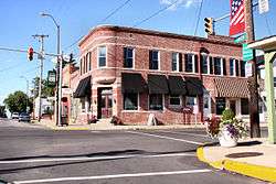 Downtown Westfield in 2005 | ||
| ||
| Nickname(s): Crossroads of Indiana | ||
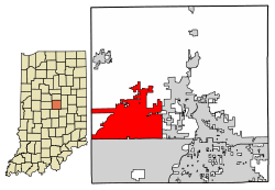 Location of Westfield in Hamilton County, Indiana. | ||
| Coordinates: 40°1′56″N 86°7′44″W / 40.03222°N 86.12889°WCoordinates: 40°1′56″N 86°7′44″W / 40.03222°N 86.12889°W | ||
| Country | United States | |
| State | Indiana | |
| County | Hamilton | |
| Founded | 1834 | |
| Government | ||
| • Mayor | Andy Cook (R) | |
| Area[1] | ||
| • Total | 29.92 sq mi (77.48 km2) | |
| • Land | 29.70 sq mi (76.92 km2) | |
| • Water | 0.22 sq mi (0.56 km2) | |
| Elevation | 886 ft (270 m) | |
| Population (2010) | ||
| • Total | 30,068 | |
| • Estimate (2017)[2] | 39,493 | |
| • Density | 1,253.27/sq mi (483.89/km2) | |
| Time zone | UTC−5 (Eastern (EST)) | |
| • Summer (DST) | UTC−4 (EDT) | |
| ZIP codes | 46074, 46032 (part), 46033 (part), 46062 (part) | |
| Area code(s) | 317 | |
| FIPS code | 18-82700[3] | |
| GNIS feature ID | 0445833[4] | |
| Website |
westfield | |

Westfield is a city in Hamilton County, Indiana, United States. As of the 2010 census the population was 30,068,[5] and in 2017 the estimated population was 39,493.[2] Westfield is in the Indianapolis metropolitan area.
History
Westfield was founded on May 6, 1834, by North Carolina Quakers Asa Bales, Ambrose Osborne and Simon Moon.[6] It is believed that the town was planned as a stop on the Underground Railroad with many families of the Religious Society of Friends and the Wesleyan Methodist Church supporting the cause. When the laws against aiding escaped slaves were made harsher, part of the Westfield Quaker Friends Meeting House split into the Anti-Slavery Friends meeting.
Westfield was incorporated as a town in 1849.[7]
On January 1, 2008, Westfield was incorporated as a city, and Andy Cook was sworn in as mayor.[8] With recent annexations in southern Washington Township and rapid population growth in areas already occupied by the pre-existing town, the city population in 2010 (30,068) was more than triple that of 2000 (9,293). Because of the growing size of the city, officials are planning a major revitalization of city's downtown. New additions to downtown Westfield are expected to include a new library and city hall.[9]
Westfield recently annexed the community of Jolietville into its borders.[10]
The Union High Academy Historic District was listed on the National Register of Historic Places in 1995.[11]
In 2014, the city opened Grand Park Sports Complex which hosted the 2016 Big Ten Conference Men's Soccer Tournament.
Demographics
| Historical population | |||
|---|---|---|---|
| Census | Pop. | %± | |
| 1850 | 1,738 | — | |
| 1870 | 608 | — | |
| 1880 | 350 | −42.4% | |
| 1890 | 815 | 132.9% | |
| 1900 | 670 | −17.8% | |
| 1910 | 700 | 4.5% | |
| 1920 | 574 | −18.0% | |
| 1930 | 688 | 19.9% | |
| 1940 | 709 | 3.1% | |
| 1950 | 849 | 19.7% | |
| 1960 | 1,217 | 43.3% | |
| 1970 | 1,837 | 50.9% | |
| 1980 | 2,783 | 51.5% | |
| 1990 | 3,304 | 18.7% | |
| 2000 | 9,293 | 181.3% | |
| 2010 | 30,068 | 223.6% | |
| Est. 2017 | 39,493 | [2] | 31.3% |
| U.S. Decennial Census[12] | |||
As of 2000 the median income for a household was $52,963; and for a family, $65,208. Males had a median income of $45,388; females, $26,864. The per capita income was $22,160. About 2.3% of families and 4.0% of the population were below the poverty line, including 2.5% of those under 18 years and 3.7% 65 years or over. The American Community Survey estimated the median household income in Westfield from 2007-2011 at $86,054 and the median family income at $96,374.[13]
2010 census
As of the census of 2010,[14] there were 30,068 people, 10,490 households, and 8,146 families residing in the town. The population density was 1,120.3 inhabitants per square mile (432.6/km2). There were 11,209 housing units at an average density of 417.6 per square mile (161.2/km2). The racial makeup of the town was 90.9% White, 2.2% African American, 0.2% Native American, 2.5% Asian, 2.6% from other races, and 1.6% from two or more races. Hispanic or Latino of any race were 5.8% of the population.
There were 10,490 households of which 47.0% had children under the age of 18 living with them, 64.9% were married couples living together, 9.3% had a female householder with no husband present, 3.4% had a male householder with no wife present, and 22.3% were non-families. 18.0% of all households were made up of individuals and 4.6% had someone living alone who was 65 years of age or older. The average household size was 2.85 and the average family size was 3.27.
The median age in the town was 33.7 years. 31.9% of residents were under the age of 18; 5.9% were between the ages of 18 and 24; 31.6% were from 25 to 44; 23.7% were from 45 to 64; and 6.8% were 65 years of age or older. The gender makeup of the town was 48.9% male and 51.1% female.
Local media
Westfield is served by a local weekly newspaper, the Current in Westfield. The area is also served by the Times of Noblesville and the daily Hamilton County Reporter from the neighboring county seat of Noblesville.[15]
Grand Park
Grand Park is the largest youth sports campus in the United States, featuring 26 baseball and softball diamonds, 31 multipurpose fields for soccer, football, rugby, field hockey and lacrosse. An indoor events center opened in July 2016 that features 3 full-size multipurpose fields, and an indoor basketball/volleyball facility that features 8 courts, with 2 of them being NBA regulated, also opened and is named after the NBA's Indiana Pacers. Grand Park features an abundance of green space and more than 10 miles (16 km) of pedestrian/bicycle trails, including the largest trailhead on the Monon Corridor.
Since opening, the campus has hosted several major events including the following: Whale of a Sale Consignment Event, Little League Softball and Baseball Region Tournaments, USA Archery Finals, Big Ten Women's and Men's Soccer Tournaments, US Club Soccer NPL Finals and Nationals, Suburban Indy Consumer Shows, plus many more.
In 2017 Westfield signed a 10-year contract with the NFL's Indianapolis Colts for their annual training camp.
The park has experienced about 750,000 visitors and 1,900,000 visits on average each year.
Geography
Westfield is located in western Hamilton County at 40°1′56″N 86°7′44″W / 40.03222°N 86.12889°W (40.032266, -86.129015).[16] It is bordered to the east by Noblesville and to the south by Carmel. To the west it is bordered by Zionsville in Boone County.
U.S. Route 31 is the main highway through the city, leading north 31 miles (50 km) to Kokomo and south 9 miles (14 km) to Interstate 465, the beltway around Indianapolis. Downtown Indianapolis is 20 miles (32 km) south of the center of Westfield. Indiana State Road 32 is Westfield's Main Street and leads east 6 miles (10 km) to Noblesville, the county seat, and west 18 miles (29 km) to Lebanon.
According to the 2010 census, Westfield has a total area of 27.081 square miles (70.14 km2), of which 26.84 square miles (69.52 km2) (or 99.11%) is land and 0.241 square miles (0.62 km2) (or 0.89%) is water.[17]
Notable people
- Herb Baumeister, alleged serial killer
- Claude Bowers, writer, Democratic politician, and ambassador to Spain and Chile
- Martha Doan, chemist and academic
- Thomas Jefferson Lindley, Civil War veteran, Indiana state representative and senator
- Seth Cook Rees, pastor; leading figure in the evangelical "holiness movement"
- Kevin Plawecki, Major League Baseball catcher, Westfield High School graduate
- Ambrose J. Tomlinson, first General Overseer, Church of God (Cleveland, Tennessee)
- Eriq Zavaleta, professional soccer player, Toronto FC
Education
Public
- Westfield High School (Grades 9-12)
- Westfield Middle School (Grades 7-8)
- Westfield Intermediate School (Grades 5-6)
- Carey Ridge Elementary School (Grades K-4)
- Maple Glen Elementary School (Grades K-4)
- Monon Trail Elementary School (Grades K-4)
- Oak Trace Elementary School (Grades K-4)
- Shamrock Springs Elementary School (Grades K-4)
- Washington Woods Elementary School (Grades K-4)
Private
- Montessori School of Westfield
- St Maria Goretti School (Grades PreK-8)
- Union Bible College and Academy
Public library
The town has a lending library, the Westfield-Washington Public Library.[18]
Sports
Westfield hosts the Great Lakes Regional Tournament in the Little League World Series each year. The tournament is held at the Grand Park Sports Campus.
References
- ↑ "2016 U.S. Gazetteer Files". United States Census Bureau. Retrieved Jul 28, 2017.
- 1 2 3 "Population and Housing Unit Estimates". Retrieved June 9, 2017.
- ↑ "American FactFinder". United States Census Bureau. Retrieved 2008-01-31.
- ↑ "US Board on Geographic Names". United States Geological Survey. 2007-10-25. Retrieved 2008-01-31.
- ↑ "Geographic Identifiers: 2010 Demographic Profile Data (G001): Westfield town, Indiana". American Factfinder. U.S. Census Bureau. Retrieved June 15, 2017.
- ↑ Haines, John F. (1915). History of Hamilton County, Indiana: Her People, Industries and Institutions, Volume 1. B.F. Bowen & Co. pp. 235–237.
- ↑ Shirts, Augustus Finch (1901). A History of the Formation, Settlement and Development of Hamilton County, Indiana: From the Year 1818 to the Close of the Civil War. p. 207.
- ↑ "Indianapolis Star". Indianapolis Star.
- ↑ "Archived copy" (PDF). Archived from the original (PDF) on March 13, 2016. Retrieved July 25, 2010.
- ↑ 2012 Boundary and Annexation Survey (BAS): Westfield city, IN, United States Census Bureau.
- ↑ National Park Service (2010-07-09). "National Register Information System". National Register of Historic Places. National Park Service.
- ↑ "Census of Population and Housing". Census.gov. Retrieved June 4, 2015.
- ↑ "American FactFinder Selected Economic Characteristics". United States Census Bureau. Retrieved 2013-12-15.
- ↑ "American FactFinder". United States Census Bureau. Retrieved 2012-12-11.
- ↑ "Main Home". Current Publishing.
- ↑ "US Gazetteer files: 2010, 2000, and 1990". United States Census Bureau. 2011-02-12. Retrieved 2011-04-23.
- ↑ "G001 - Geographic Identifiers - 2010 Census Summary File 1". United States Census Bureau. Retrieved 2015-07-29.
- ↑ "Indiana public library directory" (PDF). Indiana State Library. Retrieved 7 March 2018.
External links

- City of Westfield official website
- Westfield Washington Schools
- Westfield Portal maintained by school system
- Westfield-Washington Historical Society
- Westfield Washington Public Library
Places adjacent to Westfield, Indiana | ||||||||||
|---|---|---|---|---|---|---|---|---|---|---|
| ||||||||||
Municipalities and communities of Hamilton County, Indiana, United States | ||
|---|---|---|
| Cities | ||
| Towns | ||
| Townships | ||
| Unincorporated communities | ||
| Footnotes | ‡This populated place also has portions in an adjacent county or counties | |
.jpg)
