Clay Township, Knox County, Ohio
| Clay Township, Knox County Ohio | |
|---|---|
| Township | |
 Fields on the township's northern edge | |
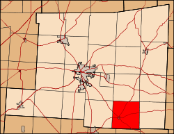 Location of Clay Township in Knox County. | |
| Coordinates: 40°16′24″N 82°19′41″W / 40.27333°N 82.32806°WCoordinates: 40°16′24″N 82°19′41″W / 40.27333°N 82.32806°W | |
| Country | United States |
| State | Ohio |
| County | Knox |
| Area | |
| • Total | 25.2 sq mi (65.2 km2) |
| • Land | 25.2 sq mi (65.2 km2) |
| • Water | 0.0 sq mi (0.0 km2) |
| Elevation[1] | 1,096 ft (334 m) |
| Population (2010) | |
| • Total | 1,604 |
| • Density | 63.7/sq mi (24.6/km2) |
| Time zone | UTC-5 (Eastern (EST)) |
| • Summer (DST) | UTC-4 (EDT) |
| FIPS code | 39-15504[2] |
| GNIS feature ID | 1086394[1] |
Clay Township is one of the twenty-two townships of Knox County, Ohio, United States. The 2010 census found 1,604 people in the township, 1,367 of whom lived in the unincorporated portions of the township.[3]
Geography
Located in the southeastern part of the county, it borders the following townships:
- Harrison Township - north
- Butler Township - northeast corner
- Jackson Township - east
- Fallsbury Township, Licking County - southeast corner
- Eden Township, Licking County - south
- Washington Township, Licking County - southwest
- Morgan Township - west
- Pleasant Township - northwest corner
The village of Martinsburg is located in western Clay Township, and the unincorporated community of Bladensburg lies on the eastern border with Jackson Township.
Name and history
Clay Township was organized in 1825. It is named for Henry Clay, senator from Kentucky.[4]
It is one of nine Clay Townships statewide.[5]
Government
The township is governed by a three-member board of trustees, who are elected in November of odd-numbered years to a four-year term beginning on the following January 1. Two are elected in the year after the presidential election and one is elected in the year before it. There is also an elected township fiscal officer,[6] who serves a four-year term beginning on April 1 of the year after the election, which is held in November of the year before the presidential election. Vacancies in the fiscal officership or on the board of trustees are filled by the remaining trustees.
References
- 1 2 "US Board on Geographic Names". United States Geological Survey. 2007-10-25. Retrieved 2008-01-31.
- ↑ "American FactFinder". United States Census Bureau. Archived from the original on 2013-09-11. Retrieved 2008-01-31.
- ↑ "American FactFinder". United States Census Bureau. Retrieved 26 July 2018.
- ↑ Graham, Albert Adams (1881). History of Knox County, Ohio: Its Past and Present, Containing a Condensed, Comprehensive History of Ohio. A. A. Graham & Company. p. 437.
- ↑ "Detailed map of Ohio" (PDF). United States Census Bureau. 2000. Retrieved 2007-02-16.
- ↑ §503.24, §505.01, and §507.01 of the Ohio Revised Code. Accessed 4/30/2009.
External links
Municipalities and communities of Knox County, Ohio, United States | ||
|---|---|---|
| City | 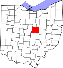 | |
| Villages | ||
| Townships | ||
| CDPs | ||
| Unincorporated communities | ||
| Ghost town | ||
| Footnotes | ‡This populated place also has portions in an adjacent county or counties | |