Hindman, Kentucky
| Hindman, Kentucky | |
|---|---|
| City | |
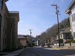 Main Street | |
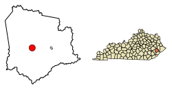 Location of Hindman in Knott County, Kentucky. | |
| Coordinates: 37°20′14″N 82°58′52″W / 37.33722°N 82.98111°WCoordinates: 37°20′14″N 82°58′52″W / 37.33722°N 82.98111°W | |
| Country | United States |
| State | Kentucky |
| County | Knott |
| Incorporated | March 23, 1886 |
| Named for | Lt. Gov. James Hindman |
| Government | |
| • Type | Mayor-Council |
| • Mayor | Tracy Neice |
| Area | |
| • Total | 3.4 sq mi (8.8 km2) |
| • Land | 3.4 sq mi (8.8 km2) |
| • Water | 0.0 sq mi (0.0 km2) |
| Elevation | 1,115 ft (340 m) |
| Population (2010) | |
| • Total | 777 |
| • Estimate (2016)[1] | 733 |
| • Density | 230/sq mi (88/km2) |
| Time zone | UTC-5 (Eastern (EST)) |
| • Summer (DST) | UTC-4 (EDT) |
| ZIP code | 41822 |
| Area code(s) | 606 |
| FIPS code | 21-37108 |
| GNIS feature ID | 0494291 |
Hindman (locally /ˈhaɪndmən/)[2] is a home rule-class city in Knott County, Kentucky, in the United States. The population was 777 at the 2010 U.S. census. It is the seat of its county.[3]
Geography
Hindman is located at 37°20′14″N 82°58′52″W / 37.33722°N 82.98111°W (37.337174, -82.981147).[4] According to the United States Census Bureau, the city has a total area of 3.4 square miles (8.8 km2), all land.
History
The land for the town was provided by local landowner and postmaster Peyton Duke,[5] but Hindman was named in honor of James Hindman, who was the lieutenant governor when the town was founded in 1884 to serve as the seat of government for the newly formed Knott County.[2]
Hindman is home to the Hindman Settlement School, which was the earliest rural settlement school.
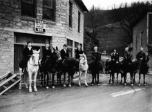
Hindman also was a central location for a pack horse library, which opened in 1935.[6]
Demographics
| Historical population | |||
|---|---|---|---|
| Census | Pop. | %± | |
| 1900 | 331 | — | |
| 1910 | 370 | 11.8% | |
| 1920 | 467 | 26.2% | |
| 1930 | 508 | 8.8% | |
| 1940 | 625 | 23.0% | |
| 1950 | 521 | −16.6% | |
| 1960 | 793 | 52.2% | |
| 1970 | 808 | 1.9% | |
| 1980 | 876 | 8.4% | |
| 1990 | 798 | −8.9% | |
| 2000 | 224 | −71.9% | |
| 2010 | 777 | 246.9% | |
| Est. 2016 | 733 | [1] | −5.7% |
| U.S. Decennial Census[7] | |||
As of the census[8] of 2000, there were 787 people, 356 households, and 220 families residing in the city. The population density was 232.5 people per square mile (89.9/km²). There were 415 housing units at an average density of 122.6 per square mile (47.4/km²). The racial makeup of the city was 97.59% White, 0.38% Native American, 0.38% from other races, and 1.65% from two or more races. Hispanic or Latino of any race were 1.27% of the population.
There were 356 households out of which 31.2% had children under the age of 18 living with them, 41.3% were married couples living together, 18.8% had a female householder with no husband present, and 38.2% were non-families. 36.0% of all households were made up of individuals and 15.7% had someone living alone who was 65 years of age or older. The average household size was 2.19 and the average family size was 2.87.
In the city, the population was spread out with 25.3% under the age of 18, 10.7% from 18 to 24, 25.4% from 25 to 44, 22.7% from 45 to 64, and 15.9% who were 65 years of age or older. The median age was 37 years. For every 100 females, there were 83.4 males. For every 100 females age 18 and over, there were 77.6 males.
The median income for a household in the city was $14,511, and the median income for a family was $21,806. Males had a median income of $31,477 versus $21,979 for females. The per capita income for the city was $11,637. About 32.0% of families and 38.9% of the population were below the poverty line, including 49.7% of those under age 18 and 22.2% of those age 65 or over.
Notable people
- Rebecca Gayheart, a television and film actress
- Carl D. Perkins, who represented the area in the U.S. House of Representatives for 35 years and whose name is associated with vocational education programs and measures to better the lives of Appalachian residents
- James Still, a poet, novelist and folklorist of Appalachia
- David Tolliver, country singer
Festivals
- Gingerbread Festival, an annual three-day festival in early September to celebrate community and Appalachian culture, featuring:
- Local arts and crafts
- Music such as folk and bluegrass
- A local parade
- The edible giant Gingerbread Man baked every year.
References
- 1 2 "Population and Housing Unit Estimates". Retrieved June 9, 2017.
- 1 2 Rennick, Robert. Kentucky Place Names, p. 141. University Press of Kentucky (Lexington), 1987. Accessed 30 July 2013.
- ↑ "Find a County". National Association of Counties. Archived from the original on May 31, 2011. Retrieved 2011-06-07.
- ↑ "US Gazetteer files: 2010, 2000, and 1990". United States Census Bureau. 2011-02-12. Retrieved 2011-04-23.
- ↑ The Kentucky Encyclopedia, pp. 433. "Hindman". University Press of Kentucky (Lexington), 1992. Accessed 30 July 2013.
- ↑ "Pictoral News Section". The Courier-Journal. 27 January 1935. Retrieved 3 September 2017 – via Newspapers.com.
- ↑ "Census of Population and Housing". Census.gov. Archived from the original on May 12, 2015. Retrieved June 4, 2015.
- ↑ "American FactFinder". United States Census Bureau. Retrieved 2008-01-31.
Further reading
- Cheeves, John; Estep, Bill (July 13, 2013). "How Eastern Kentucky's future chained to coal despite millions spent on diversification". Lexington Herald-Leader.
Municipalities and communities of Knott County, Kentucky, United States | ||
|---|---|---|
| Cities | 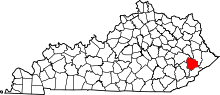 | |
| Unincorporated communities | ||
| Footnotes | ‡This populated place also has portions in an adjacent county or counties. | |
