Topmost, Kentucky
| Topmost | |
|---|---|
| Unincorporated community | |
 Topmost Location within the state of Kentucky  Topmost Topmost (the US) | |
| Coordinates: 37°21′31″N 82°47′17″W / 37.35861°N 82.78806°WCoordinates: 37°21′31″N 82°47′17″W / 37.35861°N 82.78806°W | |
| Country | United States |
| State | Kentucky |
| County | Knott |
| Elevation | 823 ft (251 m) |
| Time zone | UTC-5 (Eastern (EST)) |
| • Summer (DST) | UTC-4 (EDT) |
| ZIP codes | 41862 |
| GNIS feature ID | 505361[1] |
Topmost is an unincorporated community within Knott County, Kentucky, United States.
A 1981 coal mine explosion in Topmost killed eight miners.[2]
References
- ↑ U.S. Geological Survey Geographic Names Information System: Topmost, Kentucky
- ↑ Kleber, John (May 18, 1992). The Kentucky Encyclopedia. University Press of Kentucky. p. 523. Retrieved 2013-04-18.
Further reading
- Estep, Bill; Cheeves, John (July 6, 2013). "Pain remains more than 30 years after mine blast killed 8 on Potato Branch". Lexington Herald-Leader.
Municipalities and communities of Knott County, Kentucky, United States | ||
|---|---|---|
| Cities | 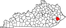 | |
| Unincorporated communities | ||
| Footnotes | ‡This populated place also has portions in an adjacent county or counties. | |
This article is issued from
Wikipedia.
The text is licensed under Creative Commons - Attribution - Sharealike.
Additional terms may apply for the media files.