Figure Eight Island
| Native name: Figure Eight | |
|---|---|
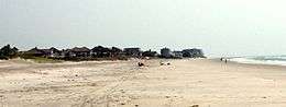 Figure Eight Island, North Carolina | |
 Figure Eight Island | |
| Geography | |
| Location |
Harnett Township, New Hanover County, North Carolina |
| Coordinates | 34°16′12″N 77°45′0″W / 34.27000°N 77.75000°W |
| Total islands | 1 |
| Area | 1,300 acres (530 ha).[1] |
| Administration | |
| Demographics | |
| Population | 441 households |
| Additional information | |
| Official website |
www |
Figure Eight Island is a North Carolina barrier island just north of Wrightsville Beach, widely known as an affluent summer colony and vacation desitination.[2] The island is part of the Wilmington Metropolitan Area, and lies between the Intracoastal Waterway and the Atlantic Ocean. As a private island, Figure Eight can only be reached by boat or via a guarded causeway swing bridge — the only private bridge over the Intracoastal Waterway in the Southeast.[3][4]
The island has been a destination for celebrities and politicians, including former Vice President Al Gore[1] and Senator John Edwards,[5] — and a summer residence for noted businessmen, including former CEO of Morgan Stanley, John J. Mack and textile executive William Johnston Armfield.[6][7]
History
Pre-development
Figure Eight Island was first recorded as part of the Province of North Carolina in 1762, during the reign of King George III, as a tract in a royal land grant to James Moore, the brother of Roger Moore of Orton Plantation and son of James Moore, Royal Governor of the Province of Carolina. Moore was also the grandson of Sir Rory O'Moore. In 1775, the island passed from James Moore to American revolutionary Cornelius Harnett and became known as The Banks. In 1795, Harnett's property was purchased at an auction by James Foy and the island became part of Poplar Grove Plantation and was renamed Foy Island and also popularly called Woods Beach. Foy Island remained a part of the Plantation for the next 160 years.[8]
During Prohibition in the 1930s, an illegal whiskey still was operated by Rod Rogers, a local fisherman, on the north end of the island. The remains of another still were found nearby.[9]
During World War II, the United States Coast Guard maintained a structure and small watertower on the island, which itself was patrolled via horseback. Coast Guard Auxiliary craft monitored the surrounding inlets. Republic P-47 Thunderbolt and Bell P-39 Airacobra aircraft based at Bluenthenthal Field used the island for strafing practice.[9]
Early development
In 1954 Hurricane Hazel hit the East Coast and destroyed much of the development from Myrtle Beach up to Topsail Beach, with more than 15,000 homes and structures completely destroyed and another 39,000 homes damaged. Beach properties were no longer in as high demand, and many landowners wanted to sell their properties. During this time the Mayor of Wilmington, Dan Cameron, and his brother Bruce Cameron began the process of acquiring the island from George Hutaff and the Foy family. The Camerons paid the Foys $50,000 for their portion of the land, and then purchased two areas of adjoining marshland for $25,000 apiece in 1955. For the next 10 years the property lay dormant. The Cameron brothers joined their cousin, Raeford Trask, and investor Richard Wetherill, forming the Island Development Company, to develop the real estate on the island. They named the island Figure Eight to indicate Rich's Inlet Creek's crooked paths in the marsh. At this time, the only way to access the island was by boat, so the Island Development Company approached Champion Davis, owner of the marshland off Porters Neck, on acquiring more land to build a bridge to the island from the mainland. Davis turned down an offer to partner with the company. The Island Development Company eventually purchased two small tracts and a small parcel of land from the members of Edgewater Club to build a roadway bridge that now leads to Figure Eight Island's bridge.[10] The first bridge was built on top of a government surplus landing ship tank.[9]
.jpg)
The Camerons hired Richard Bell Associates to design Figure Eight's development concept. John Oxenfeld and Haywood Newkirk, Sr. were brought on to design the early houses. The first lots sold for as little as $5,000, and the first house was constructed in 1966. On March 30, 1971 the Camerons sold Figure Eight Island to Young M. Smith, Jr., an attorney and developer from Hickory, North Carolina, for $4 million. Smith's company, The Litchfield Company, was already in the process of building a luxury condominium complex near Pawleys Island, South Carolina. When the change of ownership over Figure Eight took place, thirty houses and one hundred and twelve lots were sold. Smith brought architects Ligon Flynn and Henry Johnston in on the development project as well as landscape architect Dick Bell. Smith's wife was the grand niece of the late Julian Price, a wealthy insurance executive of Jefferson Standard Life Insurance Company in Greensboro. Price's son, Ralph Clay Price, who inherited the business, left his niece and her brothers as heirs to the Price estate. Much of their fortune was invested in the development of Figure Eight Island. The local marina club opened on August 11, 1973.[9]
While Figure Eight enjoyed early success in home and lot sales in the early 1970s, the recession hit The Litchfield Company hard and its subsidiary, Figure Eight Development Company, went into bankruptcy in 1974. The marina club closed down. After two open auctions were held at the New Hanover County Courthouse in 1975, Continental Illinois National Bank and Trust Company emerged as the island's new mortgage holder. The marina club reopened in 1976, and adopted the title of Figure Eight Yacht Club in the spring of 1977.[9] In 1980 a modern bridge from Port Royal, Virginia was bought to replace the old bridge connecting the island to the mainland for $1.5 million.
Recent history
.jpg)
The Figure Eight Homeowners Association now owns the island. The first full-time administrator of the Association was hired in 1982, and after several short-term managers, Arthur Poineau served as administrator for 20 years. David Kellam, the son of earlier residents on the island, has held the position since 2001. There are approximately 475 homes developed on Figure Eight. Figure Eight's boathouse was one of the first structures constructed on the island in the 1960s.[11]
In August 1974 a federal grand jury indicted fifteen people in connection to smuggling 14,000 pounds of marijuana from Colombia at Figure Eight. The smuggling ring was operated by an attorney who had rented two houses on the island. The drugs were smuggling into the island's yacht marina by the use of a sports fishing boat.[12]
Since Dino De Laurentiis opened his studio in Wilmington in 1983, Figure Eight has been a popular temporary residence for Hollywood actors working on films in Wilmington.[13][14][15]
The Shark Research Institute has recorded two non-fatal shark attacks on surfers at Figure Eight; the first on 8 August 2010 and the second on 27 August 2014.[16]
On March 14th 2018 a $2 million home on the island was destroyed by a fire while the house was undergoing renovations.[17] No one was injured in the incident.[18]
Hurricane Fran
In September 1996, Hurricane Fran damaged the island properties. All utilities and telephone lines were knocked out, septic tanks overflowed, the roads were blocked by debris and standing water, all docks were washed out, and one house was completely destroyed.[9] It took one week to pump floodwater out of low-lying areas. The yacht club building was closed for seven months for repairs.
Present day
The island has tennis courts, a boat ramp, Yacht club and a marina. The Eagle Point Golf Club, located on the mainland, has connections to Figure Eight, having been built by several Island residents.[19] The Figure Eight Yacht Club is a private island club for dining and formal events. Figure Eight is not accessible to the public by car but is by boat.[20] The majority of the residence of Figure Eight are seasonal. An estimated 90 percent of the homes on Figure Eight Islands are second homes and fewer than one hundred of the homes are on the rental market.[21] Homes on Figure Eight average above $2 million in property value.[22]
Geography
Figure Eight Island is located just north of Wrightsville Beach and Wilmington. The island has an area of 1,300 acres (526 ha),[1] most of which is marshland.
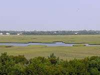
Between the northernmost part of Figure Eight and Lea-Hutaff Island lies Rich Inlet, one of the few natural inlets in North Carolina.[23] To the south, between the island and Wrightsville Beach, lies Mason Inlet.[24] The former is a stable inlet, while the latter is migratory.[9]
Ocean
Due to the island's proximity to the warm waters of the Gulf Stream, the ocean temperatures off of Figure Eight are comparable to destinations much further south and considerably warmer than the ocean off the Outer Banks.[25]
| Location | JAN | FEB | MAR | APR 1-15 | APR 16-30 | MAY 1-15 | MAY 16-31 | JUN 1-15 | JUN 16-30 | JUL 1-15 | JUL 16-31 | AUG 1-15 | AUG 16-31 | SEP 1-15 | SEP 16-30 | OCT 1-15 | OCT 16-31 | NOV | DEC |
|---|---|---|---|---|---|---|---|---|---|---|---|---|---|---|---|---|---|---|---|
| Duck, NC | 45 | 44 | 46 | 58 | 60 | 66 | 68 | 73 | 74 | 71 | 71 | 73 | 75 | 76 | 74 | 71 | 66 | 59 | 52 |
| Wilmington, NC | 58 | 58 | 62 | 69 | 72 | 75 | 78 | 80 | 81 | 82 | 83 | 82 | 83 | 83 | 82 | 79 | 75 | 69 | 62 |
| Daytona Beach, FL | 61 | 59 | 65 | 70 | 73 | 75 | 78 | 79 | 80 | 80 | 80 | 80 | 81 | 83 | 82 | 79 | 76 | 71 | 65 |
Figure Eight Island has never been subject to water quality advisories, which have been issued for nearby beaches.[26]
Wildlife
.jpg)
The local chapter of the National Audubon Society has recorded the presence of 104 different species of birds on Figure Eight. Most live in Rich Inlet, generally considered the southernmost nesting area for the critically endangered Great Lakes piping plover.[27] In 2015, approximately 800 Least Tern nested on northern section of the island, making it the largest Least Tern colony in the state, and one of the largest on the Eastern seaboard. Other birds that nested there include American Oystercatchers, Common Terns, Black Skimmers, Piping Plovers, Wilson’s Plovers and Willets.[23] Savannah Sparrows, Atlantic Plovers, Greater Yellowlegs, and pelicans have been found in Mason Inlet to the south.[24]
Conservation
.jpg)
Sea turtles have been monitored and protected on the island since 1986, and continue to be monitored on a daily basis. Sea turtle nests are cordoned off for protection. In 2016, there were 8 nests on the island.[28] In 2001 and 2002, the homeowners association commissioned a survey of endangered plants and animals on the island, including piping plovers, sea turtles, sea beach amaranth, and marine mammals.[29] The University of North Carolina at Wilmington surveyed the island's bird populations as part of the $50,000 "Mason Inlet Relocation Project" commissioned by New Hanover County.[24]
Terminal groin controversy
In early 2016, the Figure Eight Island Homeowners Association’s Board of Directors pursued the construction of a terminal groin by the United States Army Corps of Engineers on the northern section of the island to stabilize Rich Inlet and prevent erosion. Various environmental groups, including the North Carolina Coastal Federation, the Southern Environmental Law Center, and the National Audubon Society, criticized the proposal, deeming it largely unnecessary and potentially harmful to local bird and fish populations.[27][30] On November 17th, 2016 the Figure 8 Island Homeowners Association announced that the proposal to pursue a Terminal Groin did not pass and would not proceed.[31]
Fictional portrayal
In June 2001 author Wanda Canada published a murder mystery novel, titled Island Murders, which takes place on Figure Eight Island.[32][33]
See also
References
- 1 2 3 "North Carolina Vacation". Retrieved 2007-04-13.
- ↑ http://www.tracytate.com/area_comm.htm
- ↑ http://figureeighthomeowners.com/
- ↑ "Figure Eight Island Bridge".
- ↑ "Luxist". Retrieved 2007-04-13.
- ↑ "MyReporter". Retrieved 2014-01-15.
- ↑ http://www.bizjournals.com/triangle/stories/2004/07/12/story5.html
- ↑ Barefoot, Daniel W. (1995). Touring Backroads of NC Lower Coast. Touring the backroads. John F. Blair. pp. 170–171. ISBN 9780895874733.
- 1 2 3 4 5 6 7 Nadeau, Nola (July 1998). Figure Eight Revisited (2nd ed.). Wilmington, North Carolina: Litho. ASIN B000UF0F9Q.
- ↑ Coefield, Melanie, "The Mystique of Figure Eight Island", Wrightsville Beach Magazine, retrieved 1 August 2016
- ↑ "Archived copy". Archived from the original on 2014-10-10. Retrieved 2014-10-10.
- ↑ "Figure Eight Five-O", Wrightsville Beach Magazine, retrieved 4 August 2018
- ↑ http://www.myreporter.com/2013/02/what-famous-people-own-homes-in-the-wilmington-area-in-2013/
- ↑ "Archived copy". Archived from the original on 2015-06-23. Retrieved 2015-06-23.
- ↑ http://wilmonfilm.blogs.starnewsonline.com/16626/kathy-bates-confesses-to-tokin-up-on-tammy/
- ↑ "Girl, boy each lose left arm to shark bite". WRAL-TV. 14 June 2015. Retrieved 4 August 2018.
- ↑ "$2 million NC oceanfront home destroyed in massive fire". WNCN. CBS. 16 March 2018. Retrieved 4 August 2018.
- ↑ "VIDEO: Fire engulfs home on Figure Eight Island". ABC News. 14 March 2018. Retrieved 4 August 2018.
- ↑ http://www.bizjournals.com/triangle/stories/2004/07/12/story5.html?page=all
- ↑ The Public Trust Doctrine Archived 2017-02-02 at the Wayback Machine.
- ↑ http://www.wilmingtonmilliondollarhomes.com/islandcomm.php?mod=123
- ↑ http://www.justforbuyersrealty.com/figure-eight-island-realty/
- 1 2 "Rich Inlet Is Naturally Important to Birds". nc.audubon.com. National Audubon Society. Retrieved 31 July 2016.
- 1 2 3 McGrath, Gareth (20 January 2002). "For the birds" (PDF). Morning Star. Wilmington, North Carolina. Retrieved 1 August 2016.
- ↑ "Water Temperature Table of All Coastal Regions". National Oceanographic Data Center.
- ↑ "Bacteria warnings issued for Banks Channel, Wrightsville Beach locations". Retrieved 4 July 2016.
- 1 2 Talton, Trista (15 March 2016). "Experts Weigh In On Figure 8's Groin Plan". Coastal Review Online. North Carolina Coastal Federation. Retrieved 31 July 2016.
- ↑ http://www.seaturtle.org/nestdb/index.shtml?year=2016&view_beach=12
- ↑ "Department of Biological Sciences University of North Carolina". Retrieved 2007-04-13.
- ↑ Hilburn, Rachel Lewis (27 January 2016). "CoastLine: Figure 8 Island Terminal Groin Debate". whqr.org. WHQR. Retrieved 31 July 2016.
- ↑ "Figure Eight Island homeowners reject proposed terminal groin". North Carolina Costal Federation. Retrieved 29 March 2017.
- ↑ https://blogs.lib.unc.edu/ncnovels/index.php/2008/03/13/wanda-canada-island-murders/
- ↑ https://www.amazon.com/Island-Murders-Wanda-Canada/dp/1928556264
External links
Coordinates: 34°16′12″N 77°45′0″W / 34.27000°N 77.75000°W
| Preceded by Lea-Hutaff Island |
Beaches of Southeastern North Carolina | Succeeded by Wrightsville Beach |
Municipalities and communities of New Hanover County, North Carolina, United States | ||
|---|---|---|
| City |  | |
| Towns | ||
| CDPs | ||
| Unincorporated communities | ||
