Darbhanga district
| Darbhanga district | |
|---|---|
| District of Bihar | |
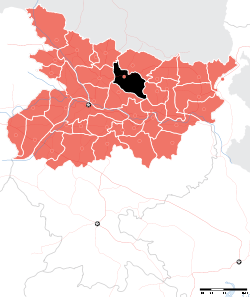 Location of Darbhanga district in Bihar | |
| Country | India |
| State | Bihar |
| Administrative division | Darbhanga |
| Headquarters | Darbhanga |
| Government | |
| • Lok Sabha constituencies | Darbhanga |
| • Assembly seats | Kusheshwar Asthan, Gaura Bauram, Benipur, Alinagar, Darbhanga Rural, Darbhanga, Hayaghat, Bahadurpur, Keoti, Jale |
| Area | |
| • Total | 2,279 km2 (880 sq mi) |
| Population (2011) | |
| • Total | 3,921,971 |
| • Density | 1,700/km2 (4,500/sq mi) |
| • Urban | 8.7 per cent |
| Demographics | |
| • Literacy | 58.26 per cent |
| • Sex ratio | 910 |
| Major highways | NH 57, NH 105 |
| Website | Official website |
Darbhanga district is one of the thirty-eight districts of Bihar state in eastern India, and Darbhanga city is the administrative headquarters of this district and 5th largest city of Bihar as well. Darbhanga district is a part of Darbhanga Division. The district is bounded on the north by Madhubani district, on the south by Samastipur district, on the east by Saharsa district and on the west by Sitamarhi and Muzaffarpur districts. The district covers an area of 2,279 km².
History
1976 saw the creations of two districts from Darbhanga's territory: Madhubani and Samastipur.[1]
Geography
Darbhanga district occupies an area of 2,279 square kilometres (880 sq mi),[2] comparatively equivalent to Indonesia's Yapen Island.[3]
Economy
In 2006, the Ministry of Panchayati Raj named Darbhanga one of the country's 250 most backward districts (out of a total of 640).[4] It is one of the 36 districts in Bihar currently receiving funds from the Backward Regions Grant Fund Programme (BRGF).[4]
Demographics
According to the 2011 census Darbhanga district has a population of 3,921,971, roughly equal to the nation of Liberia[5] or the US state of Oregon.[6] This gives it a ranking of 64th in India (out of a total of 640). The district has a population density of 1,721 inhabitants per square kilometre (4,460/sq mi). Its population growth rate over the decade 2001-2011 was 19%. Darbhanga has a sex ratio of 910 females for every 1000 males, and a literacy rate of 58.26%.
Population of this district as per 2011 census is 3,985,493 of which rural population is 3,018,639 and urban population is 306,089. According to the Census of India 2011,[7] literacy rate of the district is 44.32% (male 57.18%, female 30.35%).
See also
References
- ↑ Law, Gwillim (2011-09-25). "Districts of India". Statoids. Retrieved 2011-10-11.
- ↑ Srivastava, Dayawanti et al. (ed.) (2010). "States and Union Territories: Bihar: Government". India 2010: A Reference Annual (54th ed.). New Delhi, India: Additional Director General, Publications Division, Ministry of Information and Broadcasting (India), Government of India. pp. 1118–1119. ISBN 978-81-230-1617-7.
- ↑ "Island Directory Tables: Islands by Land Area". United Nations Environment Program. 1998-02-18. Retrieved 2011-10-11.
Yapen 2,278km2
- 1 2 Ministry of Panchayati Raj (8 September 2009). "A Note on the Backward Regions Grant Fund Programme" (PDF). National Institute of Rural Development. Archived from the original (PDF) on 5 April 2012. Retrieved 27 September 2011.
- ↑ US Directorate of Intelligence. "Country Comparison:Population". Retrieved 2011-10-01.
Liberia 3,786,764 July 2011 est.
- ↑ "2010 Resident Population Data". U. S. Census Bureau. Archived from the original on 2013-10-19. Retrieved 2011-09-30.
Oregon 3,831,074
- ↑ "District-specific Literates and Literacy Rates, 2001". Registrar General, India, Ministry of Home Affairs. Retrieved 2010-10-05.
External links
Places adjacent to Darbhanga district | |
|---|---|
| State symbols | |
|---|---|
| History |
|
| Administration | |
| Overviews | |
| Divisions and districts | |
| Cities | |
| Municipal Corporation |
|
| Poltics | |
| Culture | |