Nawada district
| Nawada district | |
|---|---|
| District of Bihar | |
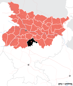 Location of Nawada district in Bihar | |
| Country | India |
| State | Bihar |
| Administrative division | Magadh |
| Headquarters | Nawada |
| Government | |
| • Lok Sabha constituencies | Nawada |
| • Assembly seats | Nawada, Hisua, Rajauli, Gobindpur & Warisaliganj. |
| Area | |
| • Total | 2,494 km2 (963 sq mi) |
| Population (2011) | |
| • Total | 2,219,146 |
| • Density | 890/km2 (2,300/sq mi) |
| • Urban | 215,579 (9.7 per cent)[1] |
| Demographics | |
| • Literacy | 59.76 per cent |
| • Sex ratio | 939 |
| Major highways | NH 20, NH 120 |
| Website | Official website |
Nawada district is one of the thirty-eight districts of the Indian state of Bihar. Nawada is its administrative headquarters. The district is the easternmost district of the Magadh division, one of the nine administrative divisions of Bihar. The area of the modern district was historically part of the Magadha, Shunga and Gupta empires. Koderma and Giridih districts of the state of Jharkhand lie on the southern border of the district; it also shares borders with the Gaya, Nalanda, Sheikhpura, and Jamui districts of Bihar.
History
Kakolat Falls are mentioned in Hindu mythology as the abode of a king turned into a python by a Rishi's curse.[2]
Geography
Nawada district occupies an area of 2,494 square kilometres (963 sq mi),[3] comparatively equivalent to Chile's Navarino Island.[4] Most parts of the district are plain but some areas are hilly. The main rivers are the Sakri, Khuri, Panchane, Bhusri by Kakolat and Tilaiya.[5]
Administrative divisions
Nawada District is divided into 14 blocks:[1]
- Hisua – Bagodar, Chhatihar, Chitarghati, Dhanwa, Dona, Eknar, Hadsa, Hisua Nagar Panchayat, Kaithir, Pachra, Sonsa, Tekpur, Tungi
- Warisaliganj – Makanpur,Apsarh, Baghi Bardiha, Barawa, Chakwae, Dosut, Hajipur, Kochgawn, Kumbhi, Kutri, Manjaur, Masudha, Mohiuddin Pur, Mosima, Naromurar, Paingari, Saur, Shahpur, Thera, Warisaliganj Nagar Panchayat,maafi,simri,may,chainpur,chandipur,balyari,baali,bilaari.
- Nawada – Bhadauni, Akauna Minhai, Amthi, Bhadokhra, Bhagwanpur, Didaur, Gonawa, Jamuawa Patwa Sarai, Jhunathi, Kharant, Loharpura, Mahuli, Nanaura, Nawada Nagar Parishad, Oraina, Paura, Quadirganj, Samai, Sonsiahri
- Kawakol – Chhabail, Darawa, Debnagar, Kawakol, Kebali, Khadshari, Lalpur, Mahudar, Manjhila, Nawadaih, Paharpur, Pali, Pandegangot, Saroni, Shekhodewra
- Akbarpur – Baksanda, Baliya Buzurg, Barail, Barew, Bhanail, Bhudhuwa, Fattehpur, Gobind Bigha, Kulna, Ladaha, Malikpur, Nemdarganj, Mankhar, Pachgawan, Pachrukhi, Paijuna, Panti, Parto Karahri, Pharaha, Sakarpura, Diri
- Narhat – Babhnaur, Jamuara, Khanwa, Konibar, Narhat, Pali Kurd, Punaul, Punthar, Saidapur Goasa, Shekhpura
- Nardiganj – Dohra, Handiya, Ichua Karna, Kahuara, Kosla, Masaurha, Nardiganj, Nanaura, Odo, Parma, Pesh
- Meskaur – Akri Pandebigha, Barat, Barosar, Biju Bigha, Meskaur, Mairzapur, Pasarhi, Rasulpur, Saraye, Tetariya
- Sirdala – Abdul, Akauna, Bandhi, Bargawan, Chaube, Chaukia, Dhiraundh, Ghaghat, Khalkhu, Khanpura, Khatangi, Laund, Rajan, Sanrh Majhgawn, Sirdala, Upardih
- Rajauli – Amawa East, Amawa West, Andharbari, Bahadurpur, Chitarkoli, Dhamni, Hardiya, Jogya Maran, Lengura, Murhena, Parka Buzurg, Rajauli Nagar Panchayat, Sawaiya Tand, Sirodabar, Takua Tand
- Pakari Barawan – Belkhunda, Budhaul, Dioura, Dakaura, Dewdha, Dhodha, Dumrawan, Euri, Jiuri, Kewala, Kunanpur, Pakri Barawan, Poksi
- Kashichak – Parwati, Rewar Jagdishpur, Chandinawa, Khakhari, Belar, Birnawa, Subhanpur, Derhgaon, Sarkatti
- Govindpur – Baksoti, Baniya Bigha, Budhwara, Madhopur, Bisunpur, Bhawanpur, Delhua, Sarkanda, Sughri, Govindpur
- Roh – Nazardih, Ohari
Economy
The main crops harvested in the district are paddy, wheat, pulses, and vegetables. Industrial facilities in the district include bidi factories and silk handlooms.[5] Formerly, sugar cane farming and processing also took place; the district's single sugar mill, located in Warisaliganj, is currently non-functional.[6] Kadirganj, located 10 km from Nawada, has a silk small scale industry where workers clean and weave silk.[7]
Rajauli and Sirdala are emerging as significant market hubs for the hinterland regions bordering Jharkhand state, and have also produced many professionals including physicians, surgeons, engineers who are working in many parts of India.[7] The Nuclear Power Corporation of India identified Rajauli as the possible site for creating an additional 2,800 MW of nuclear power capacity in the state.[8]
In 2006 the Ministry of Panchayati Raj named Nawada one of the country's 250 most backward districts (out of a total of 640).[9] It is one of the 38 districts in Bihar currently receiving funds from the Backward Regions Grant Fund Programme (BRGF).[10]
Transport
National Highway 20 runs roughly north-south through the western side of district, serving many villages and towns, including the administrative center of Nawada.[11] National Highway 120 follows a 30 km route in the far northwestern corner of the district, passing through the town of Hisua.[12] Including state highways and other routes connecting villages, the district has approximately 420 km of paved roads.[13] Deluxe buses are available from Nawada to major cities, including Patna.[14]
The district lies in the East Central Railway of Indian Railways; the Gaya–Kiul line crosses the district roughly east-west, and connects with the Bakhtiyarpur–Tilaiya line at Tilaiya Junction. Two express trains and several local trains run on the Gaya-Kiul line via Nawada railway station.[15]
Demographics
According to the 2011 census Nawada district has a population of 2,216,653,[16] roughly equal to the nation of Latvia[17] or the US state of New Mexico.[18] This gives it a ranking of 205th in India (out of a total of 640).[16] The district has a population density of 889 inhabitants per square kilometre (2,300/sq mi).[16] Its population growth rate over the decade 2001-2011 was 22.49%.[16] Nawada had a sex ratio of 936 females for every 1000 males,[16] and a literacy rate of 61.63%.[16]
References
- 1 2 District Census Handbook – Nawada (PDF). Census of India 2011. Part B: Village and Town wise Primary Census Abstract. Patna: Directorate of Census Operations, Bihar.
- ↑ "Destinations". Bihar State Tourism Development Corporation. Patna: Government of Bihar. Eco Circuit. Archived from the original on 2015-07-06. Retrieved 2015-08-21.
- ↑ Srivastava, Dayawanti; et al., eds. (2010). "States and Union Territories: Bihar: Government". India 2010: A Reference Annual (54th ed.). New Delhi: Additional Director General, Publications Division, Ministry of Information and Broadcasting (India), Government of India. pp. 1118–1119. ISBN 978-81-230-1617-7.
- ↑ "Island Directory Tables: Islands by Land Area". United Nations Environment Program. 1998-02-18. Retrieved 2011-10-11.
Navarino Island 2,473 km2
- 1 2 "District Nawada". rainrays.com.
- ↑ "Five closed sugar mills in state likely to be opened soon". The Times of India. 5 January 2012.
- 1 2 "Nawada District". bihar.com.
- ↑ BP Staff (4 February 2013). "Bihar's first Nuclear Power Plant to come up at Rajauli". biharprabha.com.
- ↑ "BRGF Overview". New Delhi: Ministry of Panchayati Raj. Archived from the original on 2016-11-25. Retrieved 2017-02-07.
- ↑ "BRGF Districts". New Delhi: Ministry of Panchayati Raj. 6 June 2014. Archived from the original on 2016-11-25. Retrieved 2017-02-07.
- ↑ ASL Advanced Systems Pvt. Ltd. Road Division Map: District - Nawada (PDF) (Map). Patna: Government of Bihar. Archived from the original (pdf) on 2012-02-24. Retrieved 2015-08-20.
- ↑ "National Highways passing through Bihar" (PDF). Bihar Road Construction Department. Patna: Government of Bihar. 2009-08-26. p. 3. Archived (PDF) from the original on 2012-02-24. Retrieved 2015-08-20.
- ↑ "State Highways and Major District Roads across State of Bihar" (PDF). Bihar Road Construction Department. Patna: Government of Bihar. March 2013. p. 28. Archived (PDF) from the original on 2015-08-21. Retrieved 2015-08-21.
- ↑ "Patna to Nawada Volvo bus service". bus-service.in.
- ↑ "Arrivals at Nawada". indiarailinfo.com.
- 1 2 3 4 5 6 "District Census 2011". Census2011.co.in. 2011. Retrieved 2011-09-30.
- ↑ US Directorate of Intelligence. "Country Comparison: Population". Retrieved 2011-10-01.
Latvia 2,204,708 July 2011 est.
- ↑ "2010 Resident Population Data". U. S. Census Bureau. Retrieved 2011-09-30.
New Mexico - 2,059,179
Places adjacent to Nawada district | ||||||||||
|---|---|---|---|---|---|---|---|---|---|---|
| ||||||||||
Coordinates: 24°45′N 85°00′E / 24.750°N 85.000°E
| State symbols | |
|---|---|
| History |
|
| Administration | |
| Overviews | |
| Divisions and districts | |
| Cities | |
| Municipal Corporation |
|
| Poltics | |
| Culture | |