Purnia division
| Purnia division | |
|---|---|
| Division of Bihar | |
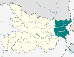 Location of Purnia division in Bihar | |
| Coordinates: 25°47′N 87°28′E / 25.78°N 87.47°ECoordinates: 25°47′N 87°28′E / 25.78°N 87.47°E | |
| Country |
|
| State | Bihar |
| Headquarters | Purnia |
| Districts | Araria, Katihar, Kishanganj and Purnia |
| Population (2011)[lower-alpha 1] | |
| • Total | 10,837,617 |
Purnia division is an administrative geographical unit of Bihar state of India. Purnia is the administrative headquarters of the division. The division consists of Purnia district, Katihar district, Araria district, and Kishanganj district in 2005.
History
Purnia division, all of which was previously part of Purnia district, is part of the Mithila region.[2] Mithila first gained prominence after being settled by Indo-Aryan peoples who established the Mithila Kingdom (also called Kingdom of the Videhas).[3] During the late Vedic period (c. 1100–500 BCE), Kingdom of the Videhas became one of the major political and cultural centers of South Asia, along with Kuru and Pañcāla. The kings of the Kingdom of the Videhas were called Janakas.[4] The Mithila Kingdom was later incorporated into the Vajji confederacy, which had its capital in the city of Vaishali, which is also in Mithila.[5]During the Mughal rule, Purnia was an outlying military province, and its revenue was mostly spent on protecting its borders against tribes from the north and east.[6] After the capture of Calcutta in 1757, Purnia's local governor raised a rebellion against Siraj ud-Daulah. In 1765, the district became a British possession, along with the rest of Bengal. [7] On February tenth, 1770 The district of Purnia in modern history was formed by the East India Company.[8] Purnia district has seen the three districts partitioned off from its territory: Katihar in 1976,[9] and Araria and Kishanganj in 1990.[9] The districts of Araria, Katihar, Purnia and Katihar together from the Purnia division.
English rule and freedom struggle
The last of the Governors was Md. Ali Khan who was replaced in 1770 by Mr. Ducarrel, the first English supervisor or Collector. The early years of British rule were years of trouble for Purnia. The district suffered terribly during the great famine of 1770. From the old records, it appears that there were European settlers in Purnia almost immediately after the establishment of British rule in the district. By 1771, a number of Europeans had settled in the area known as Rambagh, the only building left in Rambagh was the church and the priests' houses. The Roman Catholic Church was dismantled and re-erected in the new station of Purnia where the Europeans had already set up their residences. The foundation of this new church was there until 1934, when it was badly affected by the Bihar earthquake. The church was dismantled again. The nuns of Loretto convent of Darjeeling had come to Purnia near about 1882 and had opened a day school as well as a boarding school for children in Purnia district. When the Jesuit Mission of Bengal took over the Purnia Mission from the Capuchin Mission, the school was closed and the nuns returned to Darjeeling. This house still stands and is known as the Coumblin. It is one of the oldest houses in Purnia town and is now occupied by the Allisons.
Kisan Sabha movement, which had been responsible for an acute agitation in Purnia district in the third decade in 20th century and figured prominently for about 20 years, had its roots in the very agricultural economy and the precious structure of permanent land-lordism in this state. The Kisan Sabha was formed at Munger near about 1922–23. After 1940–41, the kisan sabha movement slowly merged into the Congress Movement.
Purnia district, being so very contiguous to several districts of undivided Bengal, had been promptly affected by the swadeshi movement in the first decade of the 20th century. At that time there were no facilities for higher education in Purnia district and the students who sought higher education had to go to Calcutta or to Patna. The Bihar National College and TK Ghosh Academy were suspected as the two centers for a secret students organization, which indulged in sedition and both these institutions had a sprinkling of students from Purnia. A boy from Purnia, Atul Chandra Mazumdar, a student of the BN College, Patna was arrested under the Defence Act of India.
Since 1919, Purnia had closely followed the policy, aims and objectives of the Indian National Congress. Some of the delegates of Purnia attended the Nagpur session of Congress in 1920 and the moment Mahatma Gandhi gave the call for the Non-Cooperation, there were a number of volunteers in this district. Some of the early local leaders were Gokul Krishna Roy, Satyendra Narayan Roy and a few others who gave up their practice in the Bar and joined the movement.
In 1921, a national school was started in Katihar. Shri Rajendra Prasad toured Purnia district in 1921 and addressed meetings at Purnia and at other places. In 1942 Quit India Movement tactics were fully implemented by the people of Purnia. Mahatma Gandhi visited Purnia in 1929, during which time he met the Raja of Nazargunj and addressed crowded meetings at various places including Kisahnganj, Bishnupur, Araria and Purnia. The survey and settlement operations in Purnia district commenced in 1952 and settlement operations were concluded in 1960. During the 1911–20 period, Purnia suffered from epidemics of cholera every year from 1915 to 1919. A very serious outbreak of cholera occurred in 1925. Incidences of smallpox and malaria was very high during this period.
2017 North Bihar Floods
2017 Floods affected 19 districts of North Bihar causing death of 514 people,[10][11][12][13][14][15] in which four districts of Purnia division (Araria 87, Katihar 40, Kishanganj 24 and Purnia 9) accounted for 160 deaths alone.[16]
Places of interest
Line Bazar is famous for medical facilities which caters not only to adjoining district i.e. Araria, Katihar, Madhepura, Supaul, Dalkola but also part of Nepal. Sadar hospital has multi-specialty facility with about 40 doctors. There are about 450 private doctors with multi-specialty clinics and hospitals. Dr.A.K Ojha Vidya Vihar Residential School
It is a residential boys school, 8 km from Purnea on Dhamdaha road. Students from all over Bihar come to study here. The school is run by Neharat Alumni Educational Trust.
Maa Kali Mandir, Madhubani, Purnea
Maa Kali Mandir is a very popular mandir in Madhubani (maa kali devi). On the occasion of Deepawali an organised mela occurs for four to five days.
Adampur
Mata Mandir is the very popular devi durga mandir in Adampur Purnia. In Navratra people comes from different place, and it is near the air force station, and very popular name is "matasthan". Pandit name is parihar baba.
Kamakya Mandir
Kamakya Mandir is also in the Purnea district which is very famous temple people come here for blessing of maa kamakhya which is situated at the border of three village namely - Rahua, Majra Bhabanipur and Kalayanpur. It is only 14 kilometres (9 mi) from the district headquarters. Maa kamakhya devi is a very powerful goddess in Bihar.
Ganga-Darjeeling Road
During the British Rule, Purnia division ranges from Begusarai to Darzeeling and It is almost 250 years old District. This road joins Gulab Bagh - Line Bazar- Tatma Toli - Flour Mill- Polytechnic Chowk of British Purnia and at that time. It was the Outer Circle of Purnia, that's why Khazanchi Haat Thana (Naka) is still there on this road. The most peculiar thing above all is that, after more than 50 years of independence this road has a Wooden-Bridge or Kaath Pool on Purnia - Khuskibagh Road, and not surprisingly. This Bridge is the single Wooden Bridge in National Highways of India (NH-31).
Puran-Devi and Kali Bari Temple
Located in Purnia city about 3 kilometres (1.9 mi) from the main town. It is the temple of Puran devi, a form of goddess Kali. The name of Town Purenea also as per with Goddess Puran Devi.
Dhimeshwarnath Temple-Dhima, Banmankhi
Located in Village Dhima about 3 kilometres (1.9 mi) from the main town (Banmankhi) and 34 kilometres (21.1 mi) from the District town (Purnia). It is the temple of Lord Shiva.
Baghnagar
A small village to the south-east of Araria town. Some old coins have been found recently below the earth in a cave, the bricks of which seem to be very old.
Baladiabari
A village situated about a mile and a half from Nawajganj in the south of the district. The village was the site of the battle between Shaukat Jang and Sirajuddaula in 1756.
Bandarjhula
It is situated at about 24 miles (39 km) northwest of Kishanganj near the Nepal border. Some excavation has been done here by the Archeological Department and one full size image of Vishnu made of black marble is kept here. A small fair is held every year near this image. People call this as the "Image of Kanhaiya".
BarharKothi
It is a block headquarters. The Kothi was added because of Englishman 'Kothi. There is a famous temple of the Lord Shiva, Baba Barneshwar. It is 2 km south of headquarters. Orlaha is a part of Purnea in Taluk, in Purnia District in the state of BIHAR. History and Detailed information of Orlaha. People and nearby Tourist Places in Purnea. Orlaha nearby temples, nearby popular picks in Orlaha, Purnia area product, Purnia area popular person, and can find in below for more information see information Jagdish Prasad Singh Kamat Tola. Orlaha village was an only one school 1919-1972
Kamalpur
It is one of the revenue villages of Barhara Kothi. It is very famous for Kokaful, like Lotus Flower. It is situated near a small river named Gada. There is a famous Temple of Goddess Bhagwati Vishhara Sthan, and also another famous temple like Shrikrishna Mahadev Temple in Bathaili, near village.
Barijangarh
It is a ruined fort in the Kishanganj Subdivision, situated five miles (8 km) to the south of Bahadurganj Police Station. Regarding its name, there is a legend that it was built by Barijan, a brother of Benu, Raja of Benugarh. Inside the enclosure may be traced a tank called Pokhar.
Bathnaha
There are two temples. One is a Mahadeva temple and the other that of the goddess Durga. Both are famous temple in this region.
Benugarh
A ruined fort consists of ramparts, enclosing an area of nearly an acre, and ascribed to Benu Raja, the brother of Asura.
Chakla
This place is famous for manufacture of wheels of bullock carts.
Dhima
It is 2 kilometres (1.2 mi) from the main town (Banmankhi) and 32 kilometres (19.9 mi) from the district town (Purnia). There is a famous temple of Lord Shiva, Maa Durga and Maa Kali.
Dharara
A village in the extreme west of the district, situated about 12 miles (19 km) to the south of Raniganj, and is a few miles to the north of Dhamdaha. The villagers assert that this was the place of Mahabharata episode of the Sivaic Hiranya Kans attempted slaughter of his son Prahlada for devotion to the worship of Lord Vishnu.
There was an indigo factory here and an old fort called Satl garh. At the northwest corner of the forest is a monolith called Maniktdham. The pillar is of thick inelegant shape and has the same proportions and appearance as the Ghazipur edict pillar, now in the grounds of Benaras College. The stone is light reddish granite of such fine texture as to appear almost like sandstone. It is no longer erect, but is inclined at an angle of about 65 degrees.
Forbesganj
It is the second best commercial place in the district after Bhatta bazaar. A big fair is arranged here in of November and December. Here is a famous pond known as Sultanpokhar. The town has strategic and international importance also. This is just 12 kilometers from Biratnagar, Nepal which is itself the second biggest Metro city of Nepal. Jogbani is a municipal area under the Forbesganj sub-division. Here lies the J.P.INTERNATIONAL GATE between India and Nepal.
Jalalgarh
A ruined fort in the Purnia subdivision situated 13 miles (21 km) to the north of Purnia close to the Jalalgarh railway station. It stands on what was formerly an island in the old channel of the Kosi river, and is a very conspicuous ruin in good preservation. It is a large quadrangular structure with lofty walls and was built by the Mohammedans as a frontier post to protect the border against invasion from Nepal.
According to the chronicle of the Khagra family, it was built for this purpose by the first Raja of Khagra, Saiyad Muhammad Jalal-ud-din on who the title of Raja was conferred by Jahangir (1605–27), and according to other accounts, by the Nawab of Purnia, Saif Khan, in 1722. It appears, however, to have been in existence before the later date. According to the Riyazu-s-salatin, the Raja of Birnagar had a force of 15,000 cavalry and infantry, and other inhabitants of that part of chakwar, tribe etc. were refractory and of plundering propensity, and used to annoy the travellers. Therefore, on the limits of the Marang, the fort of Jalajgarh was erected and a commandant in charge of the fort was posted here.
The fort is one mile (1.6 km) southeast of the Purnia- Araria road.
Kisanganj
Some passages in the Mahabharata describing conquest of Bhima in eastern India furnish further information about the inhabitants of this part of country. Bhima, it is said, conquered Maharaja, the king of Kanski-kocha and the land of the Pandras which is identifiable with the south Purnia. He also defeated Karna, the king of Anga, conquered the hills of tribes, killed the king of Modagri in the battle, and then subdued the powerful Pundra king.
Local tradition still speaks of the struggle and the conquest of the Kiratas. A Kirata woman from the Morang or Tarai is said to have been the wife of Raja Birat, who, it is said in Mahabharata, gave shelter to Yudhishthira and his four Pandava brothers during their 12 years of exile. The site is still pointed out at the Thakurganj in the north of this district. A big pond which is called Bhatdola to the west of Thakurganj is just adjacent to the railways lines still existing. People say that it was used by Draupadi, the wife of Panch Pandavas for cooking rice for the Pandavas. It is said to have been the site of the residence of the Raja Birat. Some stones with inscription were dug up at Thakurganj, which the villagers declare were the remains of the Birat's palace.
Kichaka Badh an ancient place which is only 3–4 miles (1.8-2.5 miles) from the Thakurganj lies in Morang. The brother-in-law of Birat Raja Kichaka was said to have resided at the palace of Birat Raja. It is said Bhima killed Kichaka here. A mela during Baruni-Snan is at this place every year for one day to offer homage to the fountain where Kichaka was killed.
Kursela
A distorted name of Kuru-Shila. Kuru-Shila means hilly part of the region which once belonged to the king Kuru, the descendents of whom were called Kaurawa and according to Mahabharata waged a war with Pandavas, their cousins.
At a distance of four miles (6 km) south, there is a range of hills known as Bateshwar Hills. There is an ancient temple of Mahadeva on the hill. Some associate the once famous Vikramshila University with this site.
Kursela had a young artist Sri Awadesh Kumar Singh, MP, son of the Zamindaar of Kursela and proprietor of the Kursela estate, R.B. Raghubansh Prasad Singh, whose paintings were exhibited at New Delhi under the tenure of Dr. S Radhakrishnan as the President. He died in 1958.
R.B. Raghubansh Prasad Singh was a great philanthropist, and administrator. He was the largest land donor in Vinobha Bhave's "Bhudan movement", wherein he donated 8,000 acres (32 km2) of land. He sponsored the opening of 2 schools and a hospital in Kursela. He also donated many houses and land to the congress party including "Kala Bhavan" in Purnea.
His younger son Sri Dinesh Kumar Singh was a Cabinet minister in the Bihar govt. for over 20 years and held portfolios including Health, Education, and Home. He died in 2005. His valuable contributions to the development of Bihar will not be forgotten by the people of Kursela.
Lanrbalu
A wide stretch of maidan runs 9 miles (14 km) from Purnia to the east with a small Idgah at one end, on which the devout Muslims assemble for their prayers. Once at this maidan, there was a fight between the mutineers and a band of loyalties led by Commissioner Yule of Bhagalpur in the Sepoy Mutiny days of 11 December 1857.
Madanpore
A village six miles (10 km) to the north east of Araria. There is a famous Shiva temple locally known as Madaneshwar Nath. A big Mela is held on the eve of Shivaratri.
Manihari
There is a mythological story that during the Mahabharata period, Lord Krishna had come to this place and had lost a Mani (a valuable jewel). Thus it came to be known as Maniharan which was changed into Manihari.
A place five miles (8 km) to the east of Manihari is connected to the story of Raja Birat of Mahabharata period that had kept a herd of cows at this place and had constructed a Bathan. There is one black stone Shiva-linga about five feet in length and three feet in width lying in an open field which is said to be of Raja Birat's time.
Sarsi
It is 18 miles (29 km) to the northwest of Purnia. There is a temple of Lord Shiva and an Idgah for Muslims. There is a ruined Kothi of an Indigo planter. Sarsi Kothi was famous indigo centre under the Europeans.
Thakurganj
It is said to be named after Bhim - the great hero of Mahabharata who served as a Thakur (cook) in the house of Raja Birat. It is mentioned in the Mahabharata that Raja Birat gave shelter to the five Pandava brothers during their one-year incognito exile. There are two tanks of Bhatdhala and Sagdhala, which the local people say were utilized by Bhim as a receptacle of Bhat and Saag after cooking. Biratnagar of the Mahabharata is said to be located here, and not in Nepal, as some stones with inscription were dug up. East of Thakurganj a small town, Sonapur, is situated just on the Siligudi highway.
Note
References
- ↑ "District Census 2011". Census 2011. Retrieved 26 December 2012.
- ↑ https://books.google.co.in/books?id=A0i94Z5C8HMC&lpg=PA30&pg=PA27&redir_esc=y#v=onepage&q&f=false
- ↑ Michael Witzel (1989), Tracing the Vedic dialects in Dialectes dans les litteratures Indo-Aryennes ed. Caillat, Paris, pages 13, 17 116–124, 141–143
- ↑ Witzel, M. (1989). "Tracing the Vedic dialects". In Caillat, C. Dialectes dans les litteratures Indo-Aryennes. Paris: Fondation Hugot. pp. 141–143.
- ↑ Hemchandra, R. (1972). Political History of Ancient India. Calcutta: University of Calcutta.
- ↑ Purnea District - Imperial Gazetteer of India, v. 20, p. 414
- ↑ Purnia District - Imperial Gazetteer of India, v. 20, p. 415
- ↑ The Times of India, Patna Edition Feb 15, 2012
- 1 2 Law, Gwillim (2011-09-25). "Districts of India". Statoids. Retrieved 2011-10-11.
- ↑ "Floods in state not man-made, says minister".
- ↑ "Flood Situation Improves In Bihar, Number Of Dead At 514".
- ↑ "Bihar flood toll reaches 418; 1.67 crore affected in 19 districts".
- ↑ "Flood situation worsens in Bihar, death toll rises to 253".
- ↑ "Bihar floods: 119 dead; bridge collapse caught on camera".
- ↑ "Bihar floods: Death toll rises to 202 in 18 districts; thundershowers likely to continue today".
- ↑ "PM Narendra Modi to make aerial survey of flood-hit Purnia today".
Railways in Bihar | |||||||||||
|---|---|---|---|---|---|---|---|---|---|---|---|
| Network Lines Sections |
| ||||||||||
| Rail Bridges | |||||||||||
| |||||||||||
| State symbols | |
|---|---|
| History |
|
| Administration | |
| Overviews | |
| Divisions and districts | |
| Cities | |
| Municipal Corporation |
|
| Poltics | |
| Culture | |