Lakhisarai district
| Lakhisarai district | |
|---|---|
| District of Bihar | |
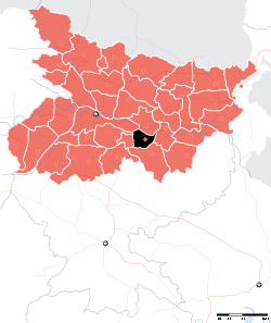 Location of Lakhisarai district in Bihar | |
| Country | India |
| State | Bihar |
| Administrative division | Munger |
| Headquarters | Lakhisarai |
| Government | |
| • Lok Sabha constituencies | Munger |
| Area | |
| • Total | 1,228 km2 (474 sq mi) |
| Population (2011) | |
| • Total | 1,000,717 |
| • Density | 810/km2 (2,100/sq mi) |
| Demographics | |
| • Literacy | 64.95 per cent |
| • Sex ratio | 900 |
| Website | Official website |
Lakhisarai district is one of the thirty-eight districts of Bihar state, India, and Lakhisarai town is the administrative headquarters of this district. Lakhisarai district is a part of Munger Division. The district occupies an area of 1228 km2. The district has a population of 8,01,173 (2001 census).
The present collector and District Magistrate of Lakhisarai is Shri Amit Kumar.[1]
Population: Total: 671634 Rural: 586294 Urban: 85340
Agriculture: Paddy, Wheat, Lentils
Rivers : Ganges, Mohane, Harohar, Kiul
History
On July 3, 1994 this district was carved out from Munger district, which comprised the erstwhile Lakhisarai sub-division of the undivided district.
Geography
Lakhisarai district occupies an area of 1,228 square kilometres (474 sq mi),[2] comparatively equivalent to Papua New Guinea's New Hanover Island.[3]
Economy
In 2006 the Ministry of Panchayati Raj named Lakhisarai one of the country's 250 districts (out of a total of 640).[4] It is one of the 36 districts in Bihar currently receiving funds from the Backward Regions Grant Fund Programme (BRGF).[4]
Divisions
The district consists only one sub-division Lakhisarai, which is divided into Seven developmental blocks, namely, Lakhisarai, Suraygarha, Barahiya, Halsi, Pipariya, Ramgarh Chowk and Chanan. The district headquarters Lakhisarai is a city with mixed population, the majority being the upper-caste (Bhumihaar-Brahmins) people. Still under the process of development, the city has one newly constructed PCC road and a bypass under construction. The Law and Order as well as development process is taking place after Nitish Kumar Govt came into Power. Also, Piribazar, Chanan police stations are naxal-prone due to their geographical layout. The city well known for its sindur (vermilion) production.
Religion
Lakhisarai is also famous for Indradameshwar Ashokdham temple, leader of Achchedin Mr.Kanhaiya Jee AnandBhagvati sthan temple at Abhaipur, Abhaynath temple at the hills beside Abhaipur Village, Maharani temple at Barahiya, Baba Govind temple at Mano-Rampur and for Shringirishi mountains and Surya Mandir at Pokhrama village in Alinagar Panchyat. This area is to be developed for Gautam Budha visits and related relics.
Industrial background
there are various fertilizer and pesticide factories in the district . one of them being BIHAR MINERAL INDUSTRIES in lakhisarai mainland . The market of fabrics is also flourihing in the district with lots of old and new shops working very well beyond estimate, there are many factories like Sindur, which play a good role in increasing GDP of India.
Demographics
According to the 2011 census Lakhisarai district has a population of 1,000,717,[5] roughly equal to the nation of Fiji[6] or the US state of Montana.[7] This gives it a ranking of 445th in India (out of a total of 640).[5] The district has a population density of 815 inhabitants per square kilometre (2,110/sq mi) .[5] Its population growth rate over the decade 2001-2011 was 24.74%.[5] Lakhisarai has a sex ratio of 900 females for every 1000 males,[5] and a literacy rate of 64.95%.[5]
See also
External links
References
- ↑ http://lakhisarai.bih.nic.in
- ↑ Srivastava, Dayawanti et al. (ed.) (2010). "States and Union Territories: Bihar: Government". India 2010: A Reference Annual (54th ed.). New Delhi, India: Additional Director General, Publications Division, Ministry of Information and Broadcasting (India), Government of India. pp. 1118–1119. ISBN 978-81-230-1617-7.
- ↑ "Island Directory Tables: Islands by Land Area". United Nations Environment Program. 1998-02-18. Retrieved 2011-10-11.
New Hanover Island (Lavongai) 1,227km2
- 1 2 Ministry of Panchayati Raj (September 8, 2009). "A Note on the Backward Regions Grant Fund Programme" (PDF). National Institute of Rural Development. Archived from the original (PDF) on April 5, 2012. Retrieved September 27, 2011.
- 1 2 3 4 5 6 "District Census 2011". Census2011.co.in. 2011. Retrieved 2011-09-30.
- ↑ US Directorate of Intelligence. "Country Comparison:Population". Retrieved 2011-10-01.
Fiji 883,125 July 2011 est.
- ↑ "2010 Resident Population Data". U. S. Census Bureau. Archived from the original on 2013-10-19. Retrieved 2011-09-30.
Montana 989,415
Places adjacent to Lakhisarai district | ||||||||||
|---|---|---|---|---|---|---|---|---|---|---|
| ||||||||||
| State symbols | |
|---|---|
| History |
|
| Administration | |
| Overviews | |
| Divisions and districts | |
| Cities | |
| Municipal Corporation |
|
| Poltics | |
| Culture | |
Coordinates: 25°10′12″N 86°05′24″E / 25.17000°N 86.09000°E