Bhagalpur district
| Bhagalpur district | |
|---|---|
| District of Bihar | |
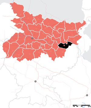 Location of Bhagalpur district in Bihar | |
| Country | India |
| State | Bihar |
| Administrative division | Bhagalpur |
| Headquarters | Bhagalpur |
| Government | |
| • Lok Sabha constituencies | Bhagalpur |
| • Assembly seats | Bhagalpur,Pirpainty, Kahalgaon,Sultanganj,Bihpur,Gopalpur |
| Area | |
| • Total | 2,569 km2 (992 sq mi) |
| Population (2011)[1] | |
| • Total | 30,37,766 |
| • Density | 1,200/km2 (3,100/sq mi) |
| • Urban | 602,532 (19.83 per cent) |
| Demographics | |
| • Literacy | 63.14 per cent |
| • Sex ratio | 880/1000 |
| Major highways | NH 33,[NH 31],[NH 80] |
| Average annual precipitation | 1166 mm |
| Website | Official website |
Bhagalpur district is one of the thirty-eight districts of Bihar state, India, and Bhagalpur town is the administrative headquarters of this district.
Geography
Bhagalpur district occupies an area of 2,569 square kilometres (992 sq mi),.[2][3] Bhagalpur district is a part of Bhagalpur Division. The river Ganges flows through the district.
National protected area
Economy
In 2006 the Indian government named Bhagalpur one of the country's 250 most backward districts (out of a total of 640).[4] It is one of the 38 districts in Bihar currently receiving funds from the Backward Regions Grant Fund Programme (BRGF). [4]
Demographics
According to the 2011 census Bhagalpur district has a population of 3,037,766,[5] roughly equal to the nation of Oman[6] or the US state of Iowa.[7] This gives it a ranking of 120th in India (out of a total of 640).[5] The district has a population density of 1,182 inhabitants per square kilometre (3,060/sq mi) .[5] Its population growth rate over the decade 2001-2011 was 25.36%.[5] Bhagalpur has a sex ratio of 880 females for every 1000 males,[5] and a literacy rate of 63.14%.[5]
Languages
The primary language used in the district is Angika. Other chief languages include Hindi, Urdu and Bengali language.[8]
Flora and fauna
In 1990 Bhagalpur district became home to the Vikramshila Gangetic Dolphin Wildlife Sanctuary, which is 50 km (31.1 mi) in length.[9]
Common Service Center in Sultanganj

- S.C.T.I CSC, KrishnaGarh
References
- ↑ http://www.censusindia.gov.in/2011census/dchb/1022_PART_B_DCHB_BHAGALPUR.pdf
- ↑ Srivastava, Dayawanti et al. (ed.) (2010). "States and Union Territories: Bihar: Government". India 2010: A Reference Annual (54th ed.). New Delhi, India: Additional Director General, Publications Division, Ministry of Information and Broadcasting (India), Government of India. pp. 1118–1119. ISBN 978-81-230-1617-7.
- ↑ "Island Directory Tables: Islands by Land Area". United Nations Environment Program. 1998-02-18. Retrieved 2011-10-11.
Obira 2,542km2
- 1 2 Ministry of Panchayati Raj (September 8, 2009). "A Note on the Backward Regions Grant Fund Programme" (PDF). National Institute of Rural Development. Archived from the original (PDF) on April 5, 2012. Retrieved September 27, 2011.
- 1 2 3 4 5 6 "Census India Bhagalpur District" (PDF). Census2011.co.in. 2011. Retrieved 2011-09-30.
- ↑ US Directorate of Intelligence. "Country Comparison:Population". Retrieved 2011-10-01.
Oman 3,027,959
- ↑ "2010 Resident Population Data". U. S. Census Bureau. Archived from the original on 2013-10-19. Retrieved 2011-09-30.
Iowa 3,046,355
- ↑ M. Paul Lewis, ed. (2009). "Angika: A language of India". Ethnologue: Languages of the World (16th ed.). Dallas, Texas: SIL International. Retrieved 2011-09-28.
- ↑ Indian Ministry of Forests and Environment. "Protected areas: Bihar". Archived from the original on August 23, 2011. Retrieved September 25, 2011.
External links
Places adjacent to Bhagalpur district | |
|---|---|
| State symbols | |
|---|---|
| History |
|
| Administration | |
| Overviews | |
| Divisions and districts | |
| Cities | |
| Municipal Corporation |
|
| Poltics | |
| Culture | |