Muzaffarpur district
| Muzaffarpur district | |
|---|---|
| District of Bihar | |
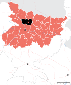 Location of Muzaffarpur district in Bihar | |
| Country | India |
| State | Bihar |
| Administrative division | Tirhut |
| Headquarters | Muzaffarpur |
| Government | |
| • Lok Sabha constituencies | Muzaffarpur, Vaishali |
| • Assembly seats | Gaighat, Aurai, Minapur, Bochahan, Sakra, Kurhani, Muzaffarpur, Kanti, Baruraj, Paroo, Sahebganj |
| Area | |
| • Total | 3,173 km2 (1,225 sq mi) |
| Population (2011) | |
| • Total | 4,801,062[1] |
| Demographics | |
| • Literacy | 63.4%[1] |
| • Sex ratio | 900 |
| Major highways | NH 57, NH 28, NH 77, NH 102, NH 527C |
| Website | Official website |
Muzaffarpur District is one of the thirty-eight districts of Bihar state, India. Muzaffarpur district is a part of Tirhut Division [2] (Tirhut).
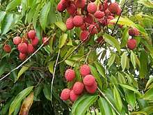
Muzaffarpur is one of the largest commercial and educational center in North Bihar. It is famous for litchis which is a fruit famous for its juicy taste. The district headquarters are located at Muzaffarpur. The district occupies an area of 3173 km² and has a population of 3,743,836 (as of 2001).
As of 2011 it is the third most populous district of Bihar (out of 38), after Patna and East Champaran.[1]
History
Muzaffarpur district was created in 1875 for the sake of administrative convenience by splitting up the earlier district of Tirhut. The present district of Muzaffarpur came to its existence in the 18th century and named after Muzaffar Khan, an Amil (Revenue Officer) under British Dynasty. Purbi Champaran and Sitamarhi districts on North, on the South Vaishali and Saran districts, on the East Darbhanga and Samastipur districts and on the West Saran and Gopalganj districts surround Muzaffarpur.
In past this district was the part of Mithila (Videha) and was ruled by King Janak, the father of Goddess Sita. As per Ramanaya, Goddess Sita (born in Sitamarhi or janakpur) married to Shri Ram. This area is also known as Tirhut. Tirhut is the another name of Mithila. After the fall of Mithila Ruler, this area went in the control of Mughals and latter in the control of Darbhanga Maharaj.
The office of Tirhut Commissioner is in Muzaffarpur itself. Muzaffarpur is also famous for its arts and culture. Mithila Painting is the famous art in this area. The people of this district celebrate Durga Puja, Kali Puja, Chhath, Sama-Chakeva etc.
In 1908 the young Bengali revolutionary, Khudi Ram Bose, an 18-year-old, was hanged for throwing the bomb at the carriage of Pringle Kennedy who was actually mistaken for Kingsford, the District Judge of Muzaffarpur. After Indian independence in 1947, a memorial to this Bose was constructed at Muzaffarpur. Bajjika Parishad in its XII Antarrashtriya Bajjika Sammelan on October 2, 2004, passed unanimously a resolution to rename the city as Khudirampur in presence of local MLA Bijendra Choudhary and MLC Devesh Chandra Thakur. However, such a resolution has only a symbolic significance as the change of name requires administrative approval.
The significance of Muzaffarpur in Indian civilization arises out of its position on the frontier line between two most spiritual influences and is a meeting place of Hindu and Islamic culture and thoughts. Muzaffarpur fostered political leaders and statesmen alike among whom were Rajendra Prasad, George Fernandes, Janki Ballabh Shastri, a great Maithili writer Parmanandan Shashtri and Devesh Chandra Thakur etc. The language of the region is Bajjika (dialect language of Maithili) as per George Grierson. However Maithili is also spoken in Muzaffarpur District.
In 1972 both Sitamarhi and Vaishali districts were split from Muzaffarpur.[3]
The city was a major centre of anti-emergency movement of Jai Prakash Narayan in the late-1970s. The politics of the city in the 1980s was greatly influenced by the movement as in the rest of Bihar. The significance of caste in politics gained prominence in the 1990s and 2000s when the party of Lalu Prasad gained prominence in the state.
Geography
Muzaffarpur district is served by rivers Gandak, Budhi Gandak, Bagmati and Lakhandayee. Also, there are lots of small streams passing through the district. The area has been prone to floods. The district lies in the fertile region of Gangetic plain. Muzaffarpur district occupies an area of 3,175.9 square kilometres (1,226.2 sq mi),[4] comparatively equivalent to Canada's Mansel Island.[5]
Economy
Long ago, the area was famous for hand-woven textiles, sugar cane, and other products. The district has a few sugar mills, which are now old and dilapidated. It is the main commercial hub of North Bihar and the wholesale market of Mumbai, Surat and Ahmedabad. Textile mills in the famous Marwari community dominate Suta Patti. The commercial hub of the City is Motijheel, Kalyani Chowk, SarriyaGanj, Jawaharlal Road, Bela Industrial Area, Club Road, Islampur, Shafi Daudi Market, Aam Gola, Chata Bazar, Company Bagh, Tilak Maidan Road, Juran Chapra, Bank Road, Mithanpura, Bhagwanpur
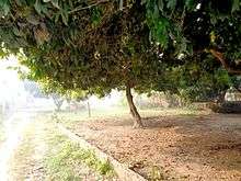
The land use around Muzaffarpur is mainly agricultural and horticultural. While litchee and mangoes are abundantly grown, principal crops are rice, wheat, pulses, jute, maize and oil seeds. Vegetables like cauliflower, cabbage, onion, tomato, radish, carrot, beetroot, among others, are also grown. Sugar cane, potato and barley are some of the non-cereal crops grown.
The main livestock of the town are cows, buffalo, goats, and poultry.
Muzaffarpur District has several industries, big and small. The railway wagon industry is one of the City landmarks. Muzaffarpur is an important centre for the wholesale cloth trade.
Bihar has emerged as brewery hub with major domestic and foreign firms setting up production units in the state. Vijay Mallya group- United Breweries Group, is setting up a production unit to make litchi-flavoured wine, in Muzaffarpur in 2012. The company has leased litchi gardens.[6]
Lychee
The litchi crop, which is available from May to June, is mainly cultivated in the districts of Muzaffarpur and surrounding districts, in an area of about 25,800 hectare producing about 300,000 tonnes every year. Lychee is exported to big cities like Bombay, Kolkata and to other countries. India's share in the world litchi market amounts to less than 1%. The names of the litchi produced in quality.[7]
Industry
It has many industries ranging from small to big. Prabhat Zarda Factory, Ganesh Foundries Limited, Bharat Wagon and Engineering Ltd., N.T.P.C., Bihar Drugs & Organic Chemicals Ltd., Muzaffarpur – a unit of IDPL, units of Leather Development Corporation, Muzaffarpur Dairy, a unit of the Bihar State Dairy Corporation unit Bihar State Cooperative Milk Producers’ Federation Ltd., Muzaffarpur producing Sudha brand packaged milk are the major industries located in Muzaffarpur city and its periphery. The above industries have generated considerable employment and have also been helpful in establishing a number of small industries including a few cottage industries. The most important item that is manufactured in Muzaffarpur town is railway wagon. Muzaffarpur city is an important centre for the wholesale cloth trade. Agro-based Industries likes Sugar mills, Britannia Biscuits have newly been established in City.[8]
Education
Muzaffarpur is the second leading centre of education in Bihar after Patna. It has a famous Business Management College named after the renowned leader of Mithila Late Lalit Narayan Mishra, known as L. N. Mishra College of Business Management, Muzaffarpur. It has a medical(Sri Krishna Medical College and Hospital) and an engineering college (Muzaffarpur Institute of Technology) and is seat of one of the oldest universities of Bihar (Bihar University, now known as B. R. Ambedkar Bihar University).The headquarters of Bihar University was at Patna.People of Muzaffarpur demanded shifting of its headquarters to Muzaffarpur.A steering committee was formed under convenorship of Dr. Maghfoor Ahmad Ajazi, other members of committee included Acharya J.B.Kripalani, Ashok Mehta, Mahamaya Pd, Mahesh pd Sinha. People movement succeeded & UGC directed Bihar Govt. to shift HQ of BU to Muzaffarpur.[9] The first president of the Indian Republic, Dr Rajendra Prasad was a teacher in the Greer Bhumihar Brahman College, Muzaffarpur. The main schools in the district are: 1. Prabhat Tara School 2. DAV Public School(Malighat, Bakhri, Kanti) 3. St. Xavier Sr./Sec. School 4. G. D. Mother International School 5. Sunshine Prep./High School 6. North Point Sr./Sec. School 7. Holly Mission Sr./Sec. School 8. Iqra Excellence School 9. The Jaintpur Public School
Demographics
According to the 2011 census Muzaffarpur district has a population of 4,801,062,[1] roughly equal to the nation of Singapore[10] or the US state of Alabama.[11] This gives it a ranking of 24th th in India (out of a total of 640).[1] The district has a population density of 1,514 inhabitants per square kilometre (3,920/sq mi).[12] Its population growth rate over the decade 2001-2011 was 28.14%.[1] Muzaffarpur has a sex ratio of 900 females for every 1000 males,[1] and a literacy rate of 63.4%.[1]
Languages
Bajjika (dialect language of Maithili) as well as Maithili is spoken by the natives of the district. However, Hindi is the language used for documentation. Urdu is the second official language. English is widely spoken all over in the state. Maithili is also a frequently used language by majority of population. The district speaking these language are darbhanga, sitamrhi, part of muzaffarpur.
Transport
Railways
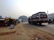
Muzaffarpur Railway Station is a main railway junction, with two suburban stations, Ram Dayalu Nagar and Narayanpur Anant (Sherpur), train connenctivity with Sitamarhi has also been started with new raliway line. Local and inter-state buses start from Imli Chatti and Bairiya Bus Stands. The airport, Patahi Airport, has small runway and no any commercial flights now.Nearest upcoming airport will be Darbhanga which is part of UDAN 2 scheme. It is well connected to major cities of Bihar like Patna, Bhagalpur, Darbhanga, Gaya , Chakia and also to other cities.
Roads

National Highway 57 (India) comes via Gorakhpur, Chakia , Motihari and crosses Muzaffarpur and National Highway 57 (India) goes to Darbhanga, Purnia. The EAST-WEST CORRIDORS crosses Muzaffarpur thus connecting it to all the major towns and cities in India. The National Highway 77 (India) starting from Hajipur passes through Muzaffarpur and connects Muzaffarpur to Sitamarhi.The National Highway 28 (India) connects Muzaffarpur to Barauni.
Airport
The district is at around 50 Km from Darbhanga Airport. Spicejet is going to start flights from Darbhanga Airport for the destinations Delhi, Mumbai & Bengaluru under UDAN Phase-II scheme.
Airlines and destinations
| Airlines | Destinations |
|---|---|
| SpiceJet | Delhi |
| SpiceJet | Mumbai, |
| SpiceJet | Bengaluru |
Maximum fare to all the three above mentioned destination would be Rs. 3470
Villages In Muzaffarpur
The most populous villages in the district are Bariarpur urf Bazidpur (42,775), Baruraj (27,064), Kanta Pirauchha (25,953) and Jajuara (25,875). Jajuara is said to be the heart of Mithila and have rich maithili culture.[13][14][15][16] The name of Jajuara has also been mentioned in the Yajur Veda.
Benibad is a very important village in Muzaffarpur district of Bihar. It is located on the National High Way 57 connecting Muzaffarpur and Darbhanga; nearly 40 kilometers away from the district headquarter Muzaffarpur. From Benibad one has to travel nearly 20 kilometers to reach Darbhanga.
According to Census 2011 information the location code or village code of Bahilwara Rupnath village is 13,356. Bahilwara Rupnath village is located in Saraiya Tehsil of Muzaffarpur district in Bihar, India.[17] It is situated 11km away from sub-district headquarter Saraiya and 25km away from district headquarter Muzaffarpur. Bahilwara Rupnath Dakshni is the gram panchayat of Bahilwara Rupnath village. The area of village is 995.73 hectares.
Bahilwara Gobind village is located in Saraiya Tehsil of Muzaffarpur district in Bihar, India. It is situated 9km away from sub-district headquarter Saraiya and 25km away from district headquarter Muzaffarpur. The area of village is 372.3 hectares. Bahilwara Gobind has a total population of 3,786 peoples. There are about 606 houses in Bahilwara Gobind village.[18] Muzaffarpur is nearest town to Bahilwara Gobind which is approximately 25km away.
There are many smaller villages, including Dora Chapara.
References
- 1 2 3 4 5 6 7 8 "District Census 2011". Census2011.co.in. 2011. Retrieved 2011-09-30.
- ↑ http://tirhut-muzaffarpur.bih.nic.in/
- ↑ Law, Gwillim (2011-09-25). "Districts of India". Statoids. Retrieved 2011-10-11.
- ↑ "Muzaffarpur Geographical At a Glance". Retrieved 2015-07-10.
- ↑ "Island Directory Tables: Islands by Land Area". United Nations Environment Program. 1998-02-18. Retrieved 2011-10-11.
Mansel Island 3,180km2
- ↑ "Bihar emerging as brewery hub". Economic Times. Retrieved 16 January 2012.
- ↑ "7. LYCHEE PRODUCTION IN INDIA". Fao.org. 1992-05-31. Retrieved 2014-08-02.
- ↑ "Archived copy". Archived from the original on 2011-08-28. Retrieved 2012-03-11.
- ↑ Vision & Mission Manorma Delhi, South Asian History & culture London, Two Circles.net, Wikimapia, Wikipedia free encyclopedia
- ↑ US Directorate of Intelligence. "Country Comparison:Population". Retrieved 2011-10-01.
Singapore 4,740,737 July 2011 est.
- ↑ "2010 Resident Population Data". U. S. Census Bureau. Retrieved 2011-09-30.
Alabama 4,779,736
- ↑ "Muzaffarpur District Population Census 2011, Bihar literacy sex ratio and density". www.census2011.co.in.
- ↑ "Bariarpur urf Bazidpur Village Population - Baruraj (Motipur) - Muzaffarpur, Bihar". www.census2011.co.in. Government of India.
- ↑ "Baruraj Village Population - Baruraj (Motipur) - Muzaffarpur, Bihar". www.census2011.co.in. Government of India.
- ↑ "Kanta Pirauchha Village Population - Gaighat - Muzaffarpur, Bihar". www.census2011.co.in. Government of India.
- ↑ "Jajuara Village Population - Katra - Muzaffarpur, Bihar". www.census2011.co.in. Government of India.
- ↑ "Bahilwara Rupnath Village Population - Saraiya - Muzaffarpur, Bihar". www.census2011.co.in. government of India.
- ↑ "Bahilwara Gobind Village Population - Saraiya - Muzaffarpur, Bihar". www.census2011.co.in. Government of India.
| Wikimedia Commons has media related to Muzaffarpur district. |
External links
Places adjacent to Muzaffarpur district | ||||||||||
|---|---|---|---|---|---|---|---|---|---|---|
| ||||||||||
| State symbols | |
|---|---|
| History |
|
| Administration | |
| Overviews | |
| Divisions and districts | |
| Cities | |
| Municipal Corporation |
|
| Poltics | |
| Culture | |
Thatiyan