Samastipur district
| Samastipur district | |
|---|---|
| District of Bihar | |
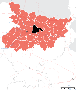 Location of Samastipur district in Bihar | |
| Country | India |
| State | Bihar |
| Administrative division | Darbhanga |
| Headquarters | Samastipur |
| Government | |
| • Lok Sabha constituencies | Samastipur, Ujiarpur |
| Area | |
| • Total | 2,904 km2 (1,121 sq mi) |
| Population (2011) | |
| • Total | 4,254,782 |
| • Density | 1,500/km2 (3,800/sq mi) |
| Demographics | |
| • Literacy | 63.81 per cent |
| • Sex ratio | 909 |
| Major highways | NH28, NH 103 |
| Website | Official website |
Samastipur is one of the thirty-eight districts of Bihar in India. The district headquarters are located at Samastipur. The district occupies an area of 2904 km² and has a population of 27,16,929 (as of 2001 Census). Sarairanjan is famous for tobacco.
History
As per district Gazetteers, Darbhanga, pages 33 to 34 Darbhanga under the Oinwar dynasty (1325-1525 AD), After a temporary period of instability, Darbhanga came under the control of the Oinwaras, also known as the Kameshwara Thakur or Sugauna Dynasty. These Hindu Chiefs were left undisturbed by the Muslim conquerors, who has by now conquered the whole of Mithila and whose exploits are indicated. The Oinwara Dynasty is noted for their encouragement of leaning and fine arts and their court served as the centre of Sanskrit belle's letters and philosophy. Among the prominent scholars of age were Gadadhara, Sankara, Vachaspati Mishra, Vidyapati, Amartakara and Amiykara. Kameshwara, the founder of dynasty, was resident of village Oini, near Pusa Road, in the District of Darbhanga. When Hazi Ilyas of Bengal divided Torhut into two parts, the Oinwara Raja shifted his Capital to Sugauna near Madhubani. The southern part of the district was under Hazi Ilyas and the northern part under the Oinwaras. The modern subdivision of Samastipur (originally Shamsuddinpur) was founded by Hazi Shamsuddin Ilyas of West Bengal.
Samastipur became a district in 1972 when it was split from Darbhanga district.[1]
Geography
Samastipur district occupies an area of 2,904 square kilometres (1,121 sq mi),[2] comparatively equivalent to Indonesia's Muna Island.[3] Samastipur is bounded on the north by the Bagmati River which separates it from Darbhanga district. On the west it is bordered by Vaishali and some part of Muzaffarpur district, on the south by the Ganges, while on its east it has Begusarai and some part of Khagaria district. The district headquarters is located at Samastipur.
Rivers
Samastipur is traversed by a number of rivers including Budhi Gandak, Baya, Kosi, Kamla, Kareh and Jhamwari and Balan, which are both the offshoots of Burhi Gandak. The Ganges also skirts the district on the south.
- Home
- Administrative Setup
- D.M. Monthly Schedule
- Important Tel. No.
- Film on VVPAT Awareness
History of Samastipur
As per district Gazetteers, Darbhanga, pages 33 to 34 Darbhanga under the Oinwaras (1325-1525 AD), After a temporary period of instability, Darbhanga came under the control of the Oinwaras, also known as the Kameshwara Thakur or Sugauna Dynasty. These Hindu Chiefs were left undisturbed by the Muslim conquerors, who has by now conquered the whole of Mithila and whose exploits are indicated. The Oinwara Dynasty is noted for their encouragement of leaning and fine arts and their court served as the centre of Sanskrit belle's letters and philosophy. Among the prominent scholars of age were Gadadhara, Sankara, Vachaspati Mishra, Vidyapati, Amartakara and Amiykara. Kameshwara, the founder of dynasty, was resident of village Oini, near Pusa Road, in the District of Darbhanga. When Hazi Ilyas of Bengal divided Torhut into two parts, the Oinwara Raja shifted his Capital to Sugauna near Madhubani. The southern part of the district was under Hazi Ilyas and the northern part under the Oinwaras. The modern subdivision of Samastipur (originally Shamsuddinpur) was founded by Hazi Shamsuddin Ilyas of West Bengal.
Samastipur became a district in 1972 when it was split from Darbhanga district.
Geography of Samastipur
Samastipur district occupies an area of 2,904 square kilometres (1,121 sq mi), [2] comparatively equivalent to Indonesia's Muna Island.[3] Samastipur is bounded on the north by the Bagmati River which separates it from Darbhanga district. On the west it is bordered by Vaishali and some part of Muzaffarpur district, on the south by the Ganges, while on its east it has Begusarai and some part of Khagaria district. The district headquarters is located at Samastipur.
Rivers
Samastipur is traversed by a number of rivers including Budhi Gandak, Baya, Kosi, Kamla, Kareh and Jhamwari and Balan, which are both the offshoots of Burhi Gandak. The Ganges also skirts the district on the south.
Agriculture of Samastipur
Samastipur is rich in agriculture, because of its fertile plain. Tobacco, maize, rice and wheat are the main crops. Leechi and mango fruits are grown in abundance. There is a jute mill in Samsastipur at Muktapur Village. This is very famous jute mill (Rameshwar Jute Mill), employing around 5000 people. Shekhopur and Kusaiya are one of the best agricultural villages and it also has famous temple, Bhagwatisthan at Manipur. Samastipur has many a sugar mills which make it a prominent player in state's sugar production.
Samastipur is major producer of potatoes. There are more than 20 cold storages in the district, all storing potatoes and total capacity is 650000 quintles.
Samastipur has also in race of consuming fertilizers.
Divisions
Samastipur district comprises the following Sub-Divisions:
- Dalsinghsarai,
- Patori,
- Rosera,
- Samastipur Sadar
Samastipur sub-division comprises eight blocks: Samastipur, Tajpur, Morwa, Khanpur, Sarairanjan, Pusa, Warisnagar, Kalyanpur.
Rosera sub-division comprises 6 blocks: Rosera, Hasanpur, Bithan, Shivaji Nagar, Singhiya, Bibhutipur.
Dalsinghsarai sub-division comprises 3 blocks: Dalsinghsarai, Ujiarpur, Vidyapati Nagar
Patori sub-division comprises 3 blocks: Patori, Mohanpur and Mohiuddin Nagar.
Economy
In 2006 the Ministry of Panchayati Raj named Samastipur one of the country's 250 most backward districts (out of a total of 640).[4] It is one of the 36 districts in Bihar receiving funds from the Backward Regions Grant Fund Programme (BRGF).[4]
Industries
Samastipur also holds Railway sub divi of East Central Railway. There are several small industries which includes Sugar Mill, Paper Mill, Jute Mill and Railway Factory.
The sugar mill and paper mill are closed. One of the major sugar mills in Hasanpur road block is still running smoothly and fulfill the desire of its local people.
Agriculture
Samastipur is rich in agriculture, because of its fertile plain. Tobacco, maize, rice and wheat are the main crops. Leechi and mango fruits are grown in abundance. Chandchour village produces vegetables and Sarairanjan,village grows tobacco, There is a jute mill in Samsastipur at Muktapur Village. This is very famous jute mill, employing around 5000 people. Shekhopur is one of the best agricultural villages and it also has famous temple, Bhagwatisthan at Manipur. Samastipur has many a sugar mills which make it a prominent player in state's sugar production.
Samastipur is major producer of potatoes. There are more than 20 cold storages in the district, all storing potatoes and total capacity is 650000 quintles.
Samastipur has also in race of consuming fertilizers.
Demographics
According to the 2011 census Samastipur district has a population of 4,254,782,[5] roughly equal to the Republic of the Congo[6] or the US state of Kentucky.[7] This gives it a ranking of 45th in India (out of a total of 640).[5] The district has a population density of 1,465 inhabitants per square kilometre (3,790/sq mi).[5] Its population growth rate over the decade 2001-2011 was 25.33%.[5] Samastipur has a sex ratio of 909 females for every 1000 males,[5] and a literacy rate of 64.21%.[5]
Culture
Culture of Samastipur is simple, beautiful and secular. It has an old tradition of folk songs and folk famous Mithila paintings, sung and done during festival and important social occasions like marriage and birth ceremonies. Several folk dance form also practiced as Kathghorwa nach, natua nach dom domin and jhijhia. Famous Sama Chakeva and Dom kach is also practiced as a culture in this area. Bhat dal and aaloo chokha is the happiest meal for every being & dhoti kurta for man & sari and salwar kurti for women is regular dress to wear.
Temples
Thaneshwar Temple is a very famous temple of Lord Shiva, and is situated at the heart of the city. Other new temples are also popping up. There are numerous other temples as well. A very famous temple Khudneshwar Sthan is also there situated in the village Morwa (Mohanpur)
Durga temple in Kessopatti is one of the oldest temple. Every year on the eve of Durga Puja pilgrims come for worship. Vidyapati Baleshwar Sthan (Shiva Temple) is one of the famous temple at Vidyapatinagar. Vidyapatinagar is known as the Nirvana sthali of the great Saint & Poet Vidyapati. Dekari, in Dalsinghsarai subdivision, is the place where Vidyapati took his last breath.
Mannipur Bhagwati Sthan is one of the very oldest and lively durga temple in Mannipur, Bhagwati Sthan. People come in numbers to pray Goddess durga everyday from far off places. This place makes realise your dream, takes away your sin. It is said that it is more than 200 years old temple and Panditji is a very learned Brahmin in samastipur.
Khudneshwar Siva Temple located 16 km from Samastipur near Morwa block is unique example of Hindu-Muslim unity. Inside the temple within a distance of about 3 meters there is Majar of Khudno Bibi along with Shiva Linga.(The History Khudno Bibi founder of Shiva Linga) Temple is under renovation by local society members. During Mahasivratri festival religious crowd from all corners of district are visiting this place for the prayer.famous kali temple in samastipur district situated in hrail village in mohiuddinnagar block.just besides of babu nathuni singh house.
Maa Bhagwati temple bhirha rosra samastipur, this temple in this area of the most famous.
Notable personalities
There are many important noted people from this district in India as well as abroad. Samastipur district has produced several nationally as well as internationally recognized scientists and famous leaders, including freedom fighters and political leaders, who have occupied ministerial posts in the Government of India have been recognized.
- Shri Satya Narayan Sinha, freedom fighter and a prominent member of Indian National Congress, who was accommodated by Pandit Jawaharlal Nehru in his first cabinet.
- Karpuri Thakur, a socialist leader of National stature became Chief Minister of Bihar twice, first in 1967 and then in 1977. He was resident of a village later named in his memory as Karpuri Gram.
- Shilpa Singh representing India at the Miss Universe 2012 pageant to held in December 2012 at Las Vegas, USA.
- Udayana, also known as Udayanācārya, was a very important Hindu logician of the tenth century who attempted to reconcile the views held by the two major schools of logic (Nyaya and Vaisheshika). This became the root of the Navya-Nyāya school of the thirteenth century, established by the Gangesha Upadhyaya ("New Nyāya") school of "right" reasoning, which is still recognized and followed in some regions of India. He lived in Kariyan village in Rosera.
- Vice Admiral Saroj Kumar Jha, who served in Indian Navy and was awarded Ati Vishisht Seva Medal in 2014, is from Rosera.
- Bhagwati Charan, renowned advocate in Samastipur and first President district bar association and chairman of municipality
- Sandep deo, renowned hindi writer whose 3-4 books becomes best seller in hindi language
- Shail Devi, use to wrote songs for Shardha Sinha( a renowned maithili singer).
Education
The district has good education facilities. It has institutions such as A.N.D. College, Shahpur Patory, Samastipur College, BRB College, RNAR College. St. Kabir College. S M R C K college. Dr. LKVD College, BBN College. The district also boasts of a Central Agricultural college in Pusa, well known as Dr.Rajendra Prasad Central Agricultural University Pusa and a proposal of Government medical college by Government of India under Pradhan Mantri Swasthya Suraksha Yojana at Jitwarpur Housing board. The district recently (in 2016) established a POLYTECHNIC college named KNS GOVT. POLYTECHNIC Samastipur in KISHANPUR TABKHA.
There are number of schools/colleges in Samastipur:-
- Central Public School
- D.A.V public School
- Holy Mission High School
- St. Paul's Senior Secondary School, Samastipur,
- Rahat Coaching Centre - A free coaching Institute for poor students. *Campus Public School Pusa
- Kameshwar Narayan Singh Govt. POLYTECHNIC Samastipur
- St. Joseph's Public School, Dalsingsarai
Sundri devi saraswati vidya mandir bataya rosera .Sundari Devi Saraswati Vidya Mandir
Progressive central high school patsa P c high school patsa
Goddess public school barki rajwahttp://www.goddesspublicschool.com
References
- ↑ Law, Gwillim (2011-09-25). "Districts of India". Statoids. Retrieved 2011-10-11.
- ↑ Srivastava, Dayawanti et al. (ed.) (2010). "States and Union Territories: Bihar: Government". India 2010: A Reference Annual (54th ed.). New Delhi, India: Additional Director General, Publications Division, Ministry of Information and Broadcasting (India), Government of India. pp. 1118–1119. ISBN 978-81-230-1617-7.
- ↑ "Island Directory Tables: Islands by Land Area". United Nations Environment Program. 1998-02-18. Retrieved 2011-10-11.
Muna 2,889km2
- 1 2 Ministry of Panchayati Raj (8 September 2009). "A Note on the Backward Regions Grant Fund Programme" (PDF). National Institute of Rural Development. Archived from the original (PDF) on 5 April 2012. Retrieved 27 September 2011.
- 1 2 3 4 5 6 "District Census 2011". Census2011.co.in. 2011. Retrieved 2011-09-30.
- ↑ US Directorate of Intelligence. "Country Comparison:Population". Retrieved 2011-10-01.
Congo, Republic of the 4,243,929
- ↑ "2010 Resident Population Data". U. S. Census Bureau. Retrieved 2011-09-30.
Kentucky 4,339,367
External links
Coordinates: 25°51′47″N 85°46′48″E / 25.86319°N 85.78001°E
| State symbols | |
|---|---|
| History |
|
| Administration | |
| Overviews | |
| Divisions and districts | |
| Cities | |
| Municipal Corporation |
|
| Poltics | |
| Culture | |
| Authority control |
|---|