Troy, Michigan
Troy is a city in Oakland County in the U.S. state of Michigan. Its population was 80,980 at the 2010 census, making Troy the most-populated city in the county and the 13th most-populated municipality in the state.
Troy, Michigan | |
|---|---|
| City of Troy | |
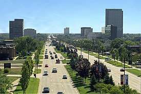 Aerial view looking east along Big Beaver Road | |
| Motto(s): The City of Tomorrow ... Today | |
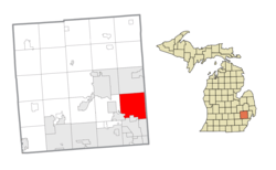 Location within Oakland County | |
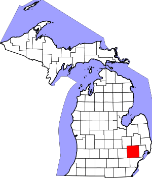
 Troy Location within the state of Michigan | |
| Coordinates: 42°34′49″N 83°08′35″W | |
| Country | United States |
| State | Michigan |
| County | Oakland |
| Settled | 1819 |
| Organized | 1827 (as Troy Township) |
| Incorporated | 1955 |
| Government | |
| • Type | Council–manager |
| • Mayor | Ethan Baker |
| • Manager | Mark F. Miller |
| Area | |
| • City | 33.64 sq mi (87.1 km2) |
| • Land | 33.47 sq mi (86.7 km2) |
| • Water | 0.17 sq mi (0.4 km2) |
| Elevation | 748 ft (228 m) |
| Population | |
| • City | 80,980 |
| • Estimate (2019)[3] | 84,092 |
| • Density | 2,504.57/sq mi (967.03/km2) |
| • Metro | 4,296,250 (Metro Detroit) |
| Time zone | UTC−5 (EST) |
| • Summer (DST) | UTC−4 (EDT) |
| ZIP code(s) | 48007, 48083–48085, 48098, 48099 |
| Area code(s) | 248 and 947 |
| FIPS code | 26-80700 |
| GNIS feature ID | 1615125[4] |
| Website | Official website |
As a northern suburb of Metro Detroit, Troy is about 6 miles (9.7 km) north of the city of Detroit. It was organized as Troy Township in 1827, and sections of the township incorporated much later into the cities of Birmingham, Clawson, and Royal Oak. The last portion of the township incorporated as the present-day city of Troy in 1955.
Troy has become a business and shopping destination in the region, with numerous office centers and the upscale Somerset Collection mall. In 2011, Troy was ranked the safest city in Michigan, as well as the 19th safest city in the nation. In 2008, Troy was ranked 22nd on a list of "Best Places to Live" in the United States by CNN Money, using criteria including housing, quality of education, economic strength, and recreational opportunities. In 2008, Troy was also ranked as the fourth most-affordable U.S. city with a median household income of approximately $79,000.[5][6][7]
History
The earliest recorded purchases of land in what was known as Troy Township occurred in 1819. A couple of years later a settlement known as Troy Corners was established due to Johnson Niles buying 160 acres in the region. The area is currently the north-central area of Troy. In 1827 Troy Township was established. In 1955 Troy was officially incorporated primarily as a strategy for preventing border cities from taking more land.
It was named after Troy, New York, as many of the early settlers, as in much of Michigan, originated from New York.[8]
Geography
According to the United States Census Bureau, the city has a total area of 33.64 square miles (87.13 km2), of which 33.47 square miles (86.69 km2) is land and 0.17 square miles (0.44 km2) (0.51%) is water.[9]
Climate
| Climate data for Troy, Michigan (48098) | |||||||||||||
|---|---|---|---|---|---|---|---|---|---|---|---|---|---|
| Month | Jan | Feb | Mar | Apr | May | Jun | Jul | Aug | Sep | Oct | Nov | Dec | Year |
| Record high °F (°C) | 66 (19) |
65 (18) |
78 (26) |
87 (31) |
92 (33) |
102 (39) |
104 (40) |
101 (38) |
98 (37) |
90 (32) |
79 (26) |
64 (18) |
104 (40) |
| Average high °F (°C) | 30 (−1) |
34 (1) |
45 (7) |
58 (14) |
70 (21) |
79 (26) |
82 (28) |
80 (27) |
73 (23) |
60 (16) |
46 (8) |
34 (1) |
58 (14) |
| Average low °F (°C) | 16 (−9) |
18 (−8) |
26 (−3) |
36 (2) |
48 (9) |
57 (14) |
61 (16) |
60 (16) |
53 (12) |
42 (6) |
32 (0) |
22 (−6) |
39 (4) |
| Record low °F (°C) | −21 (−29) |
−12 (−24) |
−5 (−21) |
8 (−13) |
24 (−4) |
34 (1) |
41 (5) |
40 (4) |
31 (−1) |
19 (−7) |
2 (−17) |
−11 (−24) |
−21 (−29) |
| Average precipitation inches (mm) | 1.77 (45) |
2.02 (51) |
2.18 (55) |
2.75 (70) |
3.16 (80) |
3.25 (83) |
2.86 (73) |
2.88 (73) |
3.10 (79) |
2.97 (75) |
2.75 (70) |
2.20 (56) |
31.89 (810) |
| Source: Intellicast[10] | |||||||||||||
Culture
The Troy Historic Village is a fully interactive historical museum chronicling the different stages of Troy's progression from its first settlers to the city it has become today. Located at the corners of Livernois Road and Wattles Road, the village is located behind the old city hall building. Open year-round, the village has ten original, complete structures which patrons may enter and observe how they functioned in the past and how they were decorated, as all buildings are full of artifacts from that period. Each structure is original and was painstakingly moved from its original location to the museum intact. Starting with a log and mud structure used by the first settlers, there is also an 18th-century schoolhouse and estate, a general store, a blacksmith's shop, a church along with the pastor's home, and the old city hall, which acts as a general museum. There is a gazebo in the center of the square which will host parties and period bands during annual festivities. Many schools from around the area plan field trips to the museum, and the church is also available for weddings.[11]
In the summer of 2005, to commemorate the city's 50th anniversary, ceramic beaver statues, each standing four feet (1.2 m) high, were displayed at various locations in the city. The beaver is the symbol of Troy, and the city's main commercial thoroughfare (Big Beaver Road) is named after it.
Troy is also home to two of the largest Protestant churches in the USA, Kensington Community Church and Woodside Bible Church.
The Greek Orthodox Archdiocese of America Metropolis of Detroit is headquartered in Troy.[12]
Sports
In 2003, Troy was named Michigan's Sportstown by Sports Illustrated magazine for having the top community sports programs in the state.[13]
Media
In addition to the Detroit News and Detroit Free Press, regional newspapers serving all of southeast Michigan, the city is served by the Daily Tribune[14] (published daily), the Observer & Eccentric[15] (which is published twice a week), the Troy Beacon (published every Thursday), the Troy Times,[16] and the Troy-Somerset Gazette and, most recently, Troy Patch.[17] The Troy Eccentric newspaper edition ceased publication in 2009.[18]
Economy
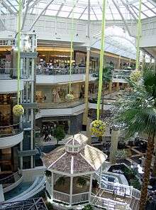
Troy is a thriving center of business, particularly in the automotive and financial sectors, and is home to a number of major companies. Troy has the second highest cumulative property value in Michigan, second only to Detroit. Troy is home to the Somerset Collection mall, featuring a skywalk and over 180 stores, and the Oakland Mall. The Top of Troy is the city's tallest building with offices of PNC Financial Services. Bank of America maintains a major operations center in Troy.
Planners have proposed the Pavilions of Troy project for the city, a landscaped square with boulevards lined with upscale shops, restaurants, offices, a theater, and condominiums.[19]
In 2012 Mahindra & Mahindra opened a technical center in Troy.[20]
Major companies

- Altair Engineering
- Anchor Bay Entertainment
- Bank of America (major center)
- Behr America
- Canadian National Railway (Traded as Grand Trunk Western)
- Champion Homes
- CredentialCheck
- Dayco
- Delphi
- DuPont Automotive
- Entertainment Publications
- Flagstar Bank
- iCONMA LLC
- Inteva Products
- J. D. Power and Associates
- Kelly Services
- The Kresge Foundation
- Magna Powertrain
- Mahindra & Mahindra
- Meritor
- Molina Healthcare
- North American Bancard
- Olga's Kitchen
- Plastic Omnium
- Plex Systems
- Rexair
- RHK Technology, Inc.
- Saleen Special Vehicles
- SAE International
- Sonic Alert
- Specter Werkes/Sports
- SRG Global
- STANLEY Black and Decker
- Syntel
- ThyssenKrupp USA
- Tyler Technologies
- ViSalus
- The Woodbridge Company (US Headquarters)
- Ziebart
- HTC Global Services
- import
Companies formerly based or located in Troy
- Arbor Drugs was headquartered in Troy until it was acquired by CVS Corporation in 1998 for an estimated $1.48 billion, in the process making CVS the largest chain-drug retailer in the Detroit market.
- Frank's Nursery & Crafts was an arts and crafts chain spanning 14 states that was headquartered in Troy, even after being acquired by General Host Corporation in 1983. The company filed for bankruptcy in 2004, and became defunct soon after.
- Kmart was headquartered in Troy until it acquired Sears in 2005, establishing itself in the former Sears headquarters in Hoffman Estates, Illinois. Its massive headquarters still remain, though they had been scheduled for demolition and the creation of a landscaped square with boulevards lined with upscale shops, restaurants, offices, a theater, and condominiums; those plans collapsed in the recession.[21]
- Genicom had a manufacturing and repairs plant, in the 1980s.
Demographics
| Historical population | |||
|---|---|---|---|
| Census | Pop. | %± | |
| 1960 | 19,402 | — | |
| 1970 | 39,419 | 103.2% | |
| 1980 | 67,102 | 70.2% | |
| 1990 | 72,884 | 8.6% | |
| 2000 | 80,959 | 11.1% | |
| 2010 | 80,980 | 0.0% | |
| Est. 2019 | 84,092 | [3] | 3.8% |
| U.S. Decennial Census[22] 2018 Estimate[23] | |||
According to a 2007 estimate, the median income for a household in the city was $84,330, and the median income for a family was $101,271. Males had a median income of $66,475 versus $41,026 for females. The per capita income for the city was $35,936. About 1.7% of families and 2.7% of the population were below the poverty line, including 2.2% of those under age 18 and 5.5% of those age 65 or over.
2010 census
As of the census[2] of 2010, there were 80,980 people, 30,703 households, and 22,443 families living in the city. The population density was 2,419.5 inhabitants per square mile (934.2/km2). There were 32,907 housing units at an average density of 983.2 per square mile (379.6/km2). The racial makeup of the city was 74.1% White, 4.0% African American, 0.2% Native American, 19.1% Asian, 0.6% from other races, and 2.0% from two or more races. Hispanic or Latino of any race were 2.1% of the population.
There were 30,703 households, of which 34.7% had children under the age of 18 living with them, 62.8% were married couples living together, 7.3% had a female householder with no husband present, 3.0% had a male householder with no wife present, and 26.9% were non-families. 23.4% of all households were made up of individuals, and 9.6% had someone living alone who was 65 years of age or older. The average household size was 2.63 and the average family size was 3.14.
The median age in the city was 41.8 years. 23.8% of residents were under the age of 18; 6.7% were between the ages of 18 and 24; 24% were from 25 to 44; 31.6% were from 45 to 64; and 13.8% were 65 years of age or older. The gender makeup of the city was 49.3% male and 50.7% female.
2000 census
From the census of 2000, there were 80,959 people, 30,018 households, and 21,883 families living in the city. The population density was 2,413.9 people per square mile (932.0/km2). There were 30,872 housing units at an average density of 920.5 per square mile (355.4/km2). The racial makeup of the city was 82.30% White, 2.09% African American, 0.15% Native American, 13.25% Asian, 0.02% Pacific Islander, 0.36% from other races, and 1.82% from two or more races. 1.46% of the population is Hispanic or Latino of any race.
There were 30,018 households, out of which 36.9% had children under the age of 18 living with them, 64.5% were married couples living together, 6.0% had a female householder with no husband present, and 27.1% were non-families. 22.8% of all households were made up of individuals, and 7.8% had someone living alone who was 65 years of age or older. The average household size was 2.69 and the average family size was 3.23.
In the city, the population was spread out, with 26.2% under the age of 18, 6.7% from 18 to 24, 29.8% from 25 to 44, 27.1% from 45 to 64, and 10.2% who were 65 years of age or older. The median age was 38 years. For every 100 females, there were 98.1 males. For every 100 females age 18 and over, there were 94.8 males.
From 1990 to 2000, of all of the municipalities in Oakland, Wayne, and Macomb counties, Troy had the highest numeric growth in the Asian population. It had 4,932 Asians according to the 1990 U.S. Census and 10,730 according to the 2000 U.S. Census, an increase of 5,798 Asians.[24] The increase gave Troy the largest Asian-American population in the tri-county area, surpassing that of Detroit.[25]
Government
Troy uses the Council-Manager form of government, and thus is governed by a City Council consisting of a Mayor and six council members. The current mayor is Ethan Baker, who was elected to a four year term on November 5, 2019. [26] The city council appoints a City Manager, who manages the day-to-day operations of the city.
The City of Troy and City of Clawson on its southern border compose Michigan's 41st District for State Representative. The district is currently represented by Padma Kuppa in the State House since 2019, and in the state Senate by Mallory McMorrow, since 2019.[27] The district was previously represented in the State House by Martin Howrylak since 2013, and in the state Senate by Marty Knollenberg, since 2015. On the national level, Troy was part of the 9th district, represented by Joe Knollenberg from 1993–2009 and Gary Peters, who defeated Knollenberg in a highly publicized race in November 2008. Nationally, Troy is part of the 11th district, held by Democrat Haley Stevens.
In May 2010, the Troy city council voted to adopt a budget that called for the Troy Public Library to close on July 1, 2011.[28] A proposal was made to increase property taxes in order for the library to run independently, but the citizens voted it down by a 2.2 percent margin. A Library millage was ultimately passed in 2011 that exists today.[29]
Education
Colleges and universities
Troy is home to Walsh College, a business-oriented school, as well as branches for the University of Phoenix, Northwood University, Central Michigan University, Spring Arbor University, and the International Academy of Design and Technology. Michigan State University also has its Management Education Center (Eli Broad College of Business) located off of I-75 near the intersection of Crooks Rd. and Square Lake Rd. (19 Mile).
Primary and secondary schools
There are 7 different school districts serving the city of Troy;[30] however, Troy School District serves almost of the city limits. The district has multiple elementary schools, four middle schools, and two zoned high schools: Troy High School and Athens High School.
There are also three school districts that have sizable portions of territory in Troy and that operate at least one elementary school within the city; these are Avondale School District, in the north and northwest most portion of the city, which operates Woodland Elementary there, Birmingham City School District, in the southwest most portion, which operates Pembroke Elementary there, and Warren Consolidated Schools, in the southeast, which operates Susick Elementary within the city.
In addition, there are two other school districts within the city that have residential territory there, those being Bloomfield Hills School District, with a portion of the northwest part of the city, and Royal Oak School District, which has a very small portion of the southern part of the city. Finally, a small area of commercial property also in the south lies within the borders of Lamphere Public Schools
The Troy School District also hosts the eastern campus of the International Academy, currently ranked 7th in the Newsweek rankings of the best public high schools in the United States. The school has been located in the older Baker Middle School building since the beginning of the 2008–2009 academic year. Previously, Troy sent students through the class of 2011 to the central IA campus in Bloomfield Hills.
Private schools:
- Bethany Christian School
- Brookfield Academy
Transportation
Oakland-Troy Airport
Oakland-Troy Airport (FAA LID: VLL, ICAO: KVLL), formerly (IATA: 7D2, ICAO: K7D2) is a small suburban general aviation airport operated by Oakland County and has a single 3,550 feet x 60 feet (1082 m x 18 m) paved runway.
The Oakland-Troy Airport is considered the County's 'executive' airport. Business travelers and tourists using private, corporate and charter aircraft benefit from the airport's convenient proximity to business, recreation and entertainment facilities.[31] It is located between Maple Road and 14 Mile Road.
Charter passenger, air freight, as well as aircraft maintenance and fuel, are available on the field.
Troy was also home to the Big Beaver Airport, (IATA: 3BB), which was located at the corners of Big Beaver Road and John R Road. It opened in 1946 and closed in 1995 due to declining use and pressure to sell the land for commercial development.[32]
Roads and freeways

M-1/Woodward Avenue and US-24/Telegraph Road are on the west side of Troy and provide access to the city.
Mile Roads
- 14 Mile Road (Southern-most border with Madison Heights)
- 15 Mile Road - Maple Road
- 16 Mile Road - Big Beaver Road
- 17 Mile Road - Wattles Road
- 18 Mile Road - Long Lake Road
- 19 Mile Road - Square Lake Road
- 20 Mile Road - South Boulevard (Northern-most border with Rochester Hills)
Notable people
- Richard Tyler Blevins, professional video gamer known as Ninja
- Chuck Collins, philanthropist and author
- Sean Collins, NHL defenseman for the Washington Capitals
- Rick Ferrell, Hall of Fame baseball player, lived in Troy
- Hunter Foster, Tony Award-nominated Broadway actor/singer
- Sutton Foster, Tony Award-winning actress, singer and dancer
- Ellen Hollman, film and television actress
- Robert J. Huber, mayor of Troy from 1959–1964, state senator and congressman
- Martin Klebba, actor, known from the Pirates of the Caribbean films and Scrubs
- Steve McCatty, former MLB pitcher and coach
- Ivana Miličević, television and film actress
- Tomo Miličević, guitarist, Thirty Seconds to Mars
- Bridget Regan, musician, Flogging Molly
- Rucka Rucka Ali, Rapper best known for black comedy style parody songs on YouTube
- Hugh W. Sloan Jr., Watergate figure
- Carolyn Warmus, high-profile killer
- We Came as Romans, rock band
- Aileen Wuornos, serial killer, executed, basis for the 2003 film Monster
- Steven Yeun, television actor, known for his role in The Walking Dead
See also
References
- "2017 U.S. Gazetteer Files". United States Census Bureau. Retrieved Jan 3, 2019.
- "U.S. Census website". United States Census Bureau. Retrieved 2012-11-25.
- "Population and Housing Unit Estimates". Retrieved May 21, 2020.
- "Troy". Geographic Names Information System. United States Geological Survey.
- "MONEY: Personal Finance News & Advice". Money.cnn.com. 2017-02-03. Retrieved 2017-07-09.
- Gopal, Prashant (29 August 2008). "America's Most and Least Affordable Housing Markets". Business Week. Archived from the original on 2008-09-08. Retrieved 25 November 2018.
- "Troy city, Michigan - Fact Sheet - American FactFinder". Web.archive.org. Archived from the original on 2007-12-22. Retrieved 2017-07-09.CS1 maint: BOT: original-url status unknown (link)
- "Why Name a City Troy?". TroyHistoricVillage. October 30, 2015.
- "Michigan: 2010 Population and Housing Unit Counts 2010 Census of Population and Housing" (PDF). 2010 United States Census. United States Census Bureau. September 2012. p. 37 Michigan. Retrieved May 1, 2020.
- "Troy Historic Averages in Michigan (48098)". Intellicast. Retrieved January 20, 2013.
- "Welcome To The Troy Historic Village". Troy Historic Village.
- "Metropolises" (Archive). Greek Orthodox Archdiocese of America. Retrieved on February 9, 2014. "Greek Orthodox Metropolis of Detroit 2560 Crooks Road, Troy, MI 48084"
- Schulman, Andrew. "City takes SI Sportstown honor for Michigan". [Sports Illustrated]. Retrieved 2011-05-01.
- "The Daily Tribune - Latest News, Sports, Opinion, Entertainment, Business, Life". Web.archive.org. Archived from the original on 2012-02-20. Retrieved 2017-07-09.
- "C & G Newspapers - Every Home, Every Week!". C&G Newspapers.
- "Troy, MI Patch - Local News, Community, Sports, Shopping, Restaurants, Things To Do". Troy, Michigan Patch.
- Observer & Eccentric Newspapers (13 April 2009). "Five Eccentric Newspapers to Cease Publication May 31". Prnewswire.com.
- Thakkar, Ketan. "Mahindra & Mahindra opens technical centre in Troy, Michigan." The Economic Times. September 25, 2012. Retrieved on November 6, 2013.
- JC Reindl, Detroit Free Press (19 October 2014). "Little action at old Kmart headquarters". Detroit Free Press.
- United States Census Bureau. "Census of Population and Housing". Retrieved March 23, 2014.
- "Population Estimates". United States Census Bureau. Retrieved June 8, 2018.
- Metzger, Kurt and Jason Booza. "Asians in the United States, Michigan and Metropolitan Detroit Archived 2013-11-09 at the Wayback Machine." Center for Urban Studies, Wayne State University. January 2002 Working Paper Series, No. 7. p. 7. Retrieved on November 6, 2013.
- Metzger, Kurt and Jason Booza. "Asians in the United States, Michigan and Metropolitan Detroit Archived 2013-11-09 at the Wayback Machine." Center for Urban Studies, Wayne State University. January 2002 Working Paper Series, No. 7. p. 10. Retrieved on November 6, 2013.
- https://www.theoaklandpress.com/news/elections/ethan-baker-elected-troy-mayor-in-landslide-says-voters-spoke-about-accountability/article_cbdd4ae6-00d4-11ea-ae96-e7028d90e418.amp.html
- https://www.detroitnews.com/story/news/politics/elections/2018/11/06/oakland-county-legislature-race-results-winners/1825027002/
- "Frequently Asked Questions about the Library Closing". Troy Public Library. 2010-06-03. Archived from the original on 2010-11-30. Retrieved 2011-04-11.
- "Troy deals with library loss". Daily Tribune. 2010-11-03. Archived from the original on March 18, 2012. Retrieved 2011-04-11.
- "Troy School District Boundaries". www.cityoftroy.maps.arcgis.com. Retrieved October 6, 2018.
- "Oakland/Troy Airport". Oakgov.com. Archived from the original on 2016-11-14. Retrieved 2017-07-09.
- Archived 2009-09-23 at the Wayback Machine
Troy residents call to keep politics out of Aug. 2 library vote
External links
| Wikimedia Commons has media related to Troy, Michigan. |
| Wikivoyage has a travel guide for Troy (Michigan). |
Places adjacent to Troy, Michigan | |
|---|---|
Municipalities and communities of Oakland County, Michigan, United States | ||
|---|---|---|
| Cities |
|  Map of Michigan highlighting Oakland County |
| Villages | ||
| Charter townships | ||
| Civil townships | ||
| Unincorporated communities |
| |
| Footnotes | ‡This populated place also has portions in an adjacent county or counties | |
| Topics |  | |
|---|---|---|
| Detroit | ||
| Municipalities over 80,000 | ||
| Municipalities 40,000 to 80,000 | ||
| Cultural enclaves | ||
| Satellite cities | ||
| Counties in MSA | ||
| Counties in CSA | ||
