Oakland County, Michigan
Oakland County is a county in the U.S. state of Michigan. It is part of the metropolitan Detroit area, located northwest of the city. As of the 2010 census, its population was 1,202,362,[3] making it the second-most populous county in Michigan, behind neighboring Wayne County. The county seat is Pontiac.[4] The county was founded in 1819 and organized in 1820.[1][5]
Oakland County | |
|---|---|
| County of Oakland | |
 | |
 Seal | |
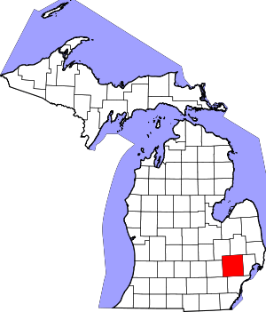 Location within the U.S. state of Michigan | |
 Michigan's location within the U.S. | |
| Coordinates: 42°40′N 83°23′W | |
| Country | |
| State | |
| Founded | January 12, 1819 (created) 1820 (organized)[1][2] |
| Seat | Pontiac |
| Largest city | Troy |
| Area | |
| • Total | 907 sq mi (2,350 km2) |
| • Land | 868 sq mi (2,250 km2) |
| • Water | 40 sq mi (100 km2) 4.4% |
| Population | |
| • Estimate (2019) | 1,257,584 |
| • Density | 1,386/sq mi (535/km2) |
| Time zone | UTC−5 (Eastern) |
| • Summer (DST) | UTC−4 (EDT) |
| Congressional districts | 8th, 9th, 11th, 14th |
| Website | www |
Oakland County is composed of 62 cities, townships, and villages, and is part of the Detroit-Warren-Dearborn, MI Metropolitan Statistical Area. The city of Detroit is in neighboring Wayne County, south of 8 Mile Road. Oakland County is among the ten highest income counties in the United States with populations over one million people.[6] It is also home to Oakland University, a large public institution that straddles the Auburn Hills and Rochester border.
The county's knowledge-based economic initiative, coined "Automation Alley", has developed one of the largest employment centers for engineering and related occupations in the United States, and some major employers include General Motors, Ford, and Chrysler, collectively known as the Big Three.
History
Founded by Territorial Governor Lewis Cass in 1819, sparsely settled Oakland was originally twice its current size. As was customary at the time, as populations increased, other counties were organized from its land area. Woodward Avenue and the Detroit and Pontiac Railroad helped draw settlers in the 1840s. By 1840, Oakland had more than fifty lumber mills, processing wood harvested from the region and the Upper Peninsula. Pontiac, located on the Clinton River, was Oakland's first town and became the county seat. After the Civil War, Oakland was still primarily a rural, agricultural county with numerous isolated villages. By the end of the 19th century, three rail lines served Pontiac, and the city attracted carriage and wagon factories. In the late 1890s streetcars were constructed here and to Detroit.
At that time, developers made southern Oakland County a suburb of Detroit; a Cincinnati firm platted a section of Royal Oak called "Urbanrest." Migration worked both ways. Several thousand people moved from Oakland County farms to Detroit as the city attracted factories. By 1910, a number of rich Detroiters had summer homes and some year-round residences in what became Bloomfield Hills. The auto age enveloped Pontiac in the early 1900s. The Oakland Motor Car Company was founded in 1907 and became a part of General Motors Corp., which was soon Pontiac's dominant firm.
In the 1950s, the Detroit metropolitan population began migrating to the suburbs, aided by the GI Bill for veterans and federal subsidies for highways and freeways. Oakland County is among the ten highest-income counties in the United States with more than one million population. The median price of a home in Oakland County increased to $164,697, more than $30,000 above the national median. Oakland County is home to popular super-regional shopping malls such as Somerset Collection, Twelve Oaks Mall, and Great Lakes Crossing Outlets.
On March 10, 2020, Michigan reported the first 2 coronavirus cases, one of which was in Oakland County.
Geography
According to the U.S. Census Bureau, the county has a total area of 907 square miles (2,350 km2), of which 868 square miles (2,250 km2) is land and 40 square miles (100 km2) (4.4%) is water.[7]
Oakland County was originally divided into 25 separate townships, which are listed below. Each township is roughly equal in size at six miles (10 km) by six miles, for a total township area of 36 square miles (93 km2). The roots of this design were born out of the Land Ordinance of 1785 and the subsequent Northwest Ordinance of 1787. Oakland County itself is a prime example of the land policy that was established, as all townships are equal in size (save for slight variations due to waterways). Section 16 in each township was reserved for financing and maintaining public education, and even today many schools in Oakland County townships are located within that section.
Wayne County, where the city of Detroit is located, borders Oakland County to the south. 8 Mile Road, also known as "Baseline Road" in some areas, is the boundary between these counties. The baseline was used during the original surveying for Michigan, and it serves as the northern/southern boundaries for counties from Lake St. Clair to Lake Michigan. As more working and middle-class populations moved to the suburbs from the 1950s on, this divide (8 Mile Road) became historically known as an unofficial racial dividing line between what became the predominantly black city and almost exclusively white suburbs.
Since the late 20th century, however, the patterns of de facto segregation have faded as the suburbs have become more diverse. Middle-class African Americans have left the city, settling in inner-ring suburbs, notably Southfield (75.08%), west of Woodward Avenue. Based on the 2010 Census, the following cities also have significant minority ethnic populations: Farmington (25.3%), Farmington Hills (31.7%), Novi (30.12%), Oak Park (62.61%), Lathrup Village (72.97%), Orchard Lake Village (16.08%), Rochester Hills (20.94%), Troy (29.4%), Wixom (26.28%), West Bloomfield (24.0%), Bloomfield (18.28%), Bloomfield Hills (14.2%), Ferndale (17.2%), and Madison Heights (17.7%). Ferndale has a concentration of Arab Americans, who also live in nearby areas, and numerous Asian Americans, particularly Indians, have also settled in these areas.
Adjacent counties
- Lapeer County (northeast)
- Genesee County (northwest)
- Macomb County (east)
- Wayne County (southeast)
- Washtenaw County (southwest)
- Livingston County (west)
Demographics
| Historical population | |||
|---|---|---|---|
| Census | Pop. | %± | |
| 1820 | 330 | — | |
| 1830 | 4,911 | 1,388.2% | |
| 1840 | 23,646 | 381.5% | |
| 1850 | 31,270 | 32.2% | |
| 1860 | 38,261 | 22.4% | |
| 1870 | 40,867 | 6.8% | |
| 1880 | 41,537 | 1.6% | |
| 1890 | 41,245 | −0.7% | |
| 1900 | 44,792 | 8.6% | |
| 1910 | 49,576 | 10.7% | |
| 1920 | 90,050 | 81.6% | |
| 1930 | 211,251 | 134.6% | |
| 1940 | 254,068 | 20.3% | |
| 1950 | 396,001 | 55.9% | |
| 1960 | 690,259 | 74.3% | |
| 1970 | 907,871 | 31.5% | |
| 1980 | 1,011,793 | 11.4% | |
| 1990 | 1,083,592 | 7.1% | |
| 2000 | 1,194,156 | 10.2% | |
| 2010 | 1,202,362 | 0.7% | |
| Est. 2019 | 1,257,584 | [8] | 4.6% |
| U.S. Decennial Census[9] 1790-1960[10] 1900-1990[11] 1990-2000[12] 2010-2019[3] | |||
As of the 2010 Census, there were 1,202,362 people and 315,175 families residing in the county. 77.3% were White, 13.6% Black or African American, 5.6% Asian, 0.3% Native American, 1.0% of some other race and 2.2% of two or more races. 3.5% were Hispanic or Latino (of any race). There were 527,255 housing units at an average density of 564 per square mile (218/km²).[13]
Regarding ancestry, in 2000 14.4% of the population were ethnically German, 9.0% Irish, 8.5% English, 8.5% Polish, 5.7% Italian and 5.5% American, 87.4% spoke only English at home; 2.0% spoke Spanish, 1.3% Syriac (Neo Aramaic) and 1.0% Arabic. The population density as of the 2000 census was 1,369 people per square mile (528/km²). There were 492,006 housing units at an average density of 564 per square mile (218/km²).
The 2000 census showed two Native American tribes with more than 1,000 members in Oakland County. There were 2,095 Cherokee and 1,458 Chippewa.
The Jewish community of metropolitan Detroit, with a population of 72,000, is the 21st largest Jewish community in the nation. This community is concentrated in Oakland County, especially in West Bloomfield, Bloomfield Hills, Farmington Hills, Troy and Huntington Woods.[14]
There were 471,115 households, of which 32.40% had children under the age of 18 living with them. 54.20% were married couples living together, 9.50% had a female householder with no husband present, and 33.10% were non-families. 27.30% of all households were made up of individuals and 8.50% had someone living alone who was 65 years of age or older. The average household size was 2.51 and the average family size was 3.09.
Among Asian Americans, eight ethnic groups had more than 1,000 members in the county in 2000. The most numerous were those of Asian Indian descent, with 20,705. Next were those of Chinese heritage, numbering 10,018. Next were those of Japanese (5,589), Filipino (5,450) Korean (5,351), Vietnamese (1,687), Pakistani (1,458) and Hmong (1,210) ancestry.[15]
In 2001, Oakland County had the 36th largest Asian population of any county in the country.[16] In 2002, of the Oakland-Wayne-Macomb tricounty area, Oakland County had 49% of the tri-county area's Asian population.[17]
The county's population was spread out in terms of age, with 25.20% of people under the age of 18, 7.20% from 18 to 24, 32.40% from 25 to 44, 23.90% from 45 to 64, and 11.30% who were 65 years of age or older. The median age was 37 years. For every 100 females, there were 95.90 males. For every 100 females age 18 and over, there were 92.70 males.
The median income for a household in the county was $86,567, making Oakland County the 21st wealthiest county in the United States: (http://www.worldatlas.com/articles/richest-counties-in-the-united-states.html). Males had a median income of $55,833 versus $35,890 for females. The per capita income for the county was $65,759. About 3.80% of families and 5.50% of the population were below the poverty line, including 6.50% of those under age 18 and 6.50% of those age 65 or over.
Government
The county government operates the jail, operates the major local courts, keeps files of deeds and mortgages, maintains vital records, administers public health regulations, and participates with the state in the provision of welfare and other social services. The county board of commissioners controls the budget but has limited authority to make laws or ordinances. In Michigan, most local government functions—police and fire, building and zoning, tax assessment, street maintenance, etc. — are the responsibility of individual cities and townships. Oakland County has an elected sheriff, and his or her law-enforcement services are used throughout the county. Fourteen cities/townships do not have municipal police forces, but rather contract with the sheriff for police services specific to the municipalities. For instance, the city of Rochester Hills does not have a "Rochester Hills Police Department," but instead has an established sheriff substation in the city with deputies who are dedicated to that city only. That branch operates as the Oakland County Sheriff's Department, Rochester Hills substation. The sheriff operates in the same manner with other municipalities who opt not to have their own police agencies. This typically is a cost-effective way for municipalities to provide police services to its citizens. The county sheriff also maintains a civil division, marine division, alcohol and traffic enforcement units, and an aviation division.
Elected officials
- County Executive: Dave Coulter (Democrat)[18]
- Prosecuting Attorney: Jessica R. Cooper (Democrat)[19]
- Sheriff: Mike Bouchard (Republican)
- County Clerk/Register of Deeds: Lisa Brown (Democrat)
- County Treasurer: Andy Meisner (Democrat)
- Water Resources Commissioner: Jim Nash (Democrat)
- Board of Commissioners: 21 members, elected from districts (11 Democrats, 10 Republicans)
(information as of August 4, 2019)
Road Commission
Roads that are not maintained by a local community (city/village) are maintained by the independent Road Commission for Oakland County, which is governed by three board members appointed by the Oakland County Board of Commissioners. Road Commissioners: Eric. S. Wilson, Chairman; Gregory C. Jamian Vice Chairman; Ron Fowkes Dennis G. Kolar, Managing Director
Oakland County Service Center
The East Campus of the Oakland County Service Center is located in Pontiac. It includes the county courthouse and jail for adults.[20]
The West Campus of the Oakland County Service Center is located in Waterford Township.[20][21] This includes the Oakland County Executive Building and Conference Center,[22] and the Oakland County Children's Village,[20] the county's juvenile detention center for children.[23] The Children's Village acts as one of the support sites for the Waterford School District.[24]
Politics
Oakland County was historically a classic bastion of suburban conservatism, and was hence a longstanding stronghold of the Republican Party. However, since the 1990s it has become more competitive and has voted for the Democratic candidate for President in the last six elections. Republican strength is concentrated in the many exurban townships of the county, while Democratic strength is concentrated in suburbs such as Royal Oak, Birmingham, West Bloomfield, and Southfield. Other suburbs such as Novi, Plymouth, and Troy are relatively split between the two parties, with younger adults tending to support Democrats and elderly residents tending to support Republicans.
In 1996, Bill Clinton became the first Democrat to secure the plurality of Oakland County presidential votes since Lyndon Johnson in 1964, and only the fourth to do so since 1892. Al Gore and John Kerry also carried the county, by narrow margins, against George W. Bush in 2000 and 2004, respectively. In 2008, Barack Obama became the first Democrat to win a majority in the county since Lyndon Johnson in 1964. (See table at right.) He again carried the county in 2012, though by a smaller margin.
While the Democratic Party has found increasing success in Presidential elections in Oakland County, the state Republican Party has remained strong in some recent gubernatorial and state elections. The county favored former Gov. Rick Snyder (R) by a 22-percent margin in the 2010 statewide elections and again by a 12-point margin in 2014, but Governor Gretchen Whitmer (D) carried the county by 17 points in 2018. While Republicans held a majority on the County Commission for most of its history, following the 2018 elections, there are 11 Democrats and 10 Republicans.[25]
In the 116th Congress, Oakland County is represented by four Democrats, Brenda Lawrence (14th), Andy Levin (9th), Haley Stevens (11th) and Elissa Slotkin (8th). Slotkin and Stevens were first elected in 2018, flipping Republican-held seats.
| Year | Republican | Democratic | Third Parties |
|---|---|---|---|
| 2016 | 43.2% 289,203 | 51.3% 343,070 | 5.5% 36,652 |
| 2012 | 45.4% 296,514 | 53.4% 349,002 | 1.2% 8,055 |
| 2008 | 41.9% 276,956 | 56.4% 372,566 | 1.7% 10,873 |
| 2004 | 49.3% 316,633 | 49.8% 319,387 | 0.9% 5,957 |
| 2000 | 48.1% 274,319 | 49.3% 281,201 | 2.6% 14,745 |
| 1996 | 43.5% 219,855 | 47.8% 241,884 | 8.7% 43,903 |
| 1992 | 43.6% 242,160 | 38.6% 214,733 | 17.8% 98,867 |
| 1988 | 61.3% 283,359 | 37.8% 174,745 | 1.0% 4,384 |
| 1984 | 66.7% 306,050 | 32.8% 150,286 | 0.5% 2,464 |
| 1980 | 54.7% 253,211 | 35.6% 164,869 | 9.8% 45,248 |
| 1976 | 58.7% 244,271 | 39.5% 164,266 | 1.8% 7,668 |
| 1972 | 63.8% 241,613 | 34.2% 129,400 | 2.1% 7,838 |
| 1968 | 45.3% 156,538 | 44.8% 154,630 | 9.9% 34,290 |
| 1964 | 38.3% 114,025 | 61.4% 182,797 | 0.2% 686 |
| 1960 | 54.3% 162,026 | 45.4% 135,531 | 0.3% 1,005 |
| 1956 | 60.4% 152,990 | 39.4% 99,901 | 0.2% 527 |
| 1952 | 60.7% 115,503 | 38.8% 73,871 | 0.4% 805 |
| 1948 | 53.5% 62,516 | 44.1% 51,491 | 2.5% 2,859 |
| 1944 | 51.5% 59,627 | 47.7% 55,272 | 0.8% 914 |
| 1940 | 50.7% 49,002 | 48.7% 47,022 | 0.6% 599 |
| 1936 | 40.6% 30,071 | 54.5% 40,329 | 4.9% 3,597 |
| 1932 | 47.8% 32,462 | 48.8% 33,135 | 3.4% 2,331 |
| 1928 | 81.5% 45,343 | 18.0% 10,011 | 0.5% 264 |
| 1924 | 81.3% 28,603 | 11.7% 4,105 | 7.1% 2,488 |
| 1920 | 71.0% 19,321 | 23.6% 6,421 | 5.4% 1,478 |
| 1916 | 51.9% 7,730 | 44.7% 6,659 | 3.5% 517 |
| 1912 | 35.5% 4,083 | 31.9% 3,668 | 32.7% 3,762 |
| 1908 | 58.2% 6,267 | 36.7% 3,950 | 5.1% 554 |
| 1904 | 61.9% 6,986 | 35.0% 3,956 | 3.1% 347 |
| 1900 | 53.0% 6,173 | 42.7% 4,966 | 4.3% 499 |
| 1896 | 46.0% 5,846 | 41.5% 5,271 | 12.5% 1,588 |
| 1892 | 45.0% 4,763 | 46.5% 4,925 | 8.5% 902 |
| 1888 | 47.3% 5,389 | 47.5% 5,410 | 5.2% 591 |
| 1884 | 45.0% 4,842 | 50.1% 5,386 | 4.9% 525 |
Transportation
Air
- Oakland County International Airport (PTK) (Waterford Township) - Charter passenger facility.
The following airports are located in neighboring counties:
- Detroit Metropolitan Wayne County Airport (DTW) (Romulus) - Major commercial airport and hub for Delta Air Lines and Spirit Airlines located in Wayne County.
- Bishop International Airport (FNT) (Flint) - Commercial airport located in Genesee County.
- Coleman A. Young International Airport (DET) (Detroit) - General aviation only. This airport is in Wayne County in the city of Detroit.
Major highways


- Grand River Avenue connects the suburbs of Brighton, Novi, and Farmington to downtown Detroit. The avenue follows the route of old US 16 before I-96 replaced it in 1962. It is one of the five roads planned by Judge August Woodward to radiate out from Detroit and connect the city to other parts of the state.
Rail
Amtrak's Wolverine serves Oakland County with 3 daily trains each way, stopping in Pontiac, Troy, Royal Oak, and continuing on to Chicago.
Mile roads
- Surface-street navigation in metro Detroit is commonly anchored by "mile roads," major east-west surface streets that are spaced at one-mile (1.6 km) intervals and increment as one travels north and away from the city center. Mile roads sometimes have two names, the numeric name (e.g., 15 Mile Road), used in Macomb County, and a local name (e.g., Maple Road), used in Oakland County (for the most part).
Bicycling
The conditions on most non-residential roads in Oakland County are not favorable to bicycling. Exceptions to this are primarily in the inner-ring suburbs within the southeast corner of the county. This is due to their street grid.
A primary reason for these unfavorable cycling conditions is the Road Commission for Oakland County has a policy of not accommodating bicycles on the road. As a result, some communities have designated sidepaths (locally called "safety paths") as bike routes which do not meet the American Association of State Highway and Transportation Officials (AASHTO) guidelines for bicycling facilities and have been found to be less safe than on-road bike facilities.[27]
As a result, there are no designated Bicycle Friendly Communities within Oakland County.
Only the city of Ferndale has a built comprehensive bicycle network of bike lanes and signed shared roadways.
Education
The County of Oakland counterpart in public education (K-12) is the Oakland Schools, an Intermediate school district.
Higher education
Oakland County is home to several institutions of higher education.
- Baker College, Auburn Hills campus
- Oakland University, Rochester
- The Western Michigan University Thomas M. Cooley Law School, Auburn Hills campus
- Lawrence Technological University, Southfield
- Rochester College, Rochester
- South University, Novi campus
- Walsh College of Accountancy and Business, Troy and Novi campuses
- Oakland Community College, five campuses: Orchard Ridge, Auburn Hills, Southfield, Highland Lakes, and Royal Oak.
- Saint Mary's College of Madonna University, Orchard Lake
- Cranbrook College of Art, Bloomfield Hills
Sports
| Club | League | Venue | Established | Championships |
|---|---|---|---|---|
| Oakland County FC | Premier League of America, Soccer | Clawson Park Stadium | 2015 |
The NFL's Detroit Lions played their home games at the Pontiac Silverdome from 1975 through 2001, when they moved to Ford Field in Downtown Detroit. The Silverdome was also the site of Super Bowl XVI, where the San Francisco 49ers defeated the Cincinnati Bengals, the first of 5 Super Bowl titles for the 49ers.
From 1988 to 2017, prior to the move to Little Caesars Arena in Detroit, the Detroit Pistons played their home games at The Palace of Auburn Hills and from 1978 to 1988, they played at the Pontiac Silverdome.
The Pontiac Silverdome also hosted various other sporting events, prior to being demolished in 2017.
The demolition of The Palace of Auburn Hills began in February 2020.
Communities
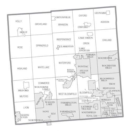
Cities
- Auburn Hills
- Berkley
- Birmingham
- Bloomfield Hills
- Clarkston
- Clawson
- Farmington
- Farmington Hills
- Fenton (mostly in Genesee County)
- Ferndale
- Hazel Park
- Huntington Woods
- Keego Harbor
- Lake Angelus
- Lathrup Village
- Madison Heights
- Northville (partially in Wayne County)
- Novi
- Oak Park
- Orchard Lake Village
- Pleasant Ridge
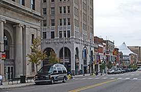
- Pontiac (county seat)
- Rochester
- Rochester Hills
- Royal Oak
- South Lyon
- Southfield
- Sylvan Lake
- Troy
- Walled Lake
- Wixom
Villages
Charter townships
- Bloomfield Charter Township
- Brandon Charter Township
- Commerce Charter Township
- Highland Charter Township
- Independence Charter Township
- Lyon Charter Township
- Milford Charter Township
- Oakland Charter Township
- Orion Charter Township
- Oxford Charter Township
- Royal Oak Charter Township
- Springfield Charter Township
- Waterford Charter Township
- West Bloomfield Charter Township
- White Lake Charter Township
Civil townships
Unincorporated communities
- Andersonville
- Austin Corners
- Brandon Gardens
- Campbells Corner
- Charing Cross
- Clintonville
- Clyde
- Commerce
- Davisburg
- Drayton Plains
- East Highland
- Elizabeth Lake
- Five Points
- Four Towns
- Gingellville
- Glengary
- Goodison
- Groveland Corners
- Hickory Ridge
- Highland
- Huron Heights
- Jossman Acres
- Kensington
- Lake Orion Heights
- Lakeville
- New Hudson
- Newark
- Oak Grove
- Oakley Park
- Oakwood
- Oxbow
- Perry Lake Heights
- Rose Center
- Rose Corners
- Rudds Mill
- Seven Harbors
- Springfield
- Thomas
- Union Lake
- Walters
- Waterford Village
- Waterstone
- West Highland
- Westacres
- White Lake
Lakes
Quarton Lake also known as The Old Mill Pond.
Rivers
There are five rivers in Oakland County:[28]
Rouge River
The headwaters of each of these rivers lie in Oakland County.
Notes
- 1.^ While Coulter was appointed acting County Executive, he has not yet been elected.
See also
- Woodward Corridor
- National Register of Historic Places listings in Oakland County, Michigan
- List of Michigan State Historic Sites in Oakland County, Michigan
- Oakland County Child Killer
- Saginaw Trail
References
- "Bibliography on Oakland County". Clarke Historical Library, Central Michigan University. Archived from the original on October 6, 2014. Retrieved January 29, 2013.
- "History of Oakland County," OaklandWeb.com. Archived July 5, 2006, at the Wayback Machine Retrieved February 7, 2007.
- "State & County QuickFacts". United States Census Bureau. Archived from the original on July 14, 2011. Retrieved August 29, 2013.
- "Find a County". National Association of Counties. Archived from the original on May 31, 2011. Retrieved June 7, 2011.
- History of Oakland County, Michigan. Philadelphia: L. H. Everts and Co. 1877. p. 23. Archived from the original on November 20, 2015. Retrieved October 4, 2014.
- "Detroit Regional Chamber of Commerce - quick facts". detroitchamber.com. Archived from the original on October 10, 2012. Retrieved April 29, 2018.
- "2010 Census Gazetteer Files". United States Census Bureau. August 22, 2012. Archived from the original on November 13, 2013. Retrieved September 27, 2014.
- "Population and Housing Unit Estimates". Retrieved March 26, 2020.
- "U.S. Decennial Census". United States Census Bureau. Retrieved September 27, 2014.
- "Historical Census Browser". University of Virginia Library. Archived from the original on August 11, 2012. Retrieved September 27, 2014.
- "Population of Counties by Decennial Census: 1900 to 1990". United States Census Bureau. Archived from the original on February 15, 2015. Retrieved September 27, 2014.
- "Census 2000 PHC-T-4. Ranking Tables for Counties: 1990 and 2000" (PDF). United States Census Bureau. Archived (PDF) from the original on December 18, 2014. Retrieved September 27, 2014.
- "Oakland County QuickFacts from the US Census Bureau". Archived from the original on July 14, 2011. Retrieved July 6, 2012.
- "Archived copy". Archived from the original on July 25, 2011. Retrieved August 4, 2009.CS1 maint: archived copy as title (link)
- See search results from United States Census Bureau. Retrieved July 2, 2007.
- Metzger, Kurt and Jason Booza. "Asians in the United States, Michigan and Metropolitan Detroit Archived November 9, 2013, at the Wayback Machine." Wayne State University Center for Urban Studies-January 2001 Working Paper Series, No. 7, p. 5. Retrieved on September 8, 2013.
- Metzger, Kurt and Jason Booza. "Asians in the United States, Michigan and Metropolitan Detroit Archived November 9, 2013, at the Wayback Machine." Center for Urban Studies, Wayne State University. January 2002 Working Paper Series, No. 7. p. 7. Retrieved on November 6, 2013.
- Laitner, Bill. "L. Brooks Patterson's successor as Oakland County executive". Detroit Free Press.
- Martindale, Mike (January 15, 2009). "New Oakland prosecutor 'going pretty hard'". The Detroit News. Retrieved March 1, 2009.
- "Complex Map" (Archived 2015-07-10 at the Wayback Machine). Oakland County Government. Retrieved on July 9, 2015.
- "Generic Base Map 2014" (Archived 2015-01-13 at the Wayback Machine). Waterford Township. Retrieved on July 10, 2015.
- "Oakland County Executive Office Building Conference Center Locator Map & Directions" (Archived 2015-07-10 at the Wayback Machine). Oakland County Government. Retrieved on July 10, 2015.
- "Oakland County Children's Village" (Archived 2015-07-10 at the Wayback Machine). The Government of Oakland County. Retrieved on July 9, 2015. "Oakland County Children's Village 1200 North Telegraph Road Pontiac, MI 48341"
- "District Map" ( Archived September 4, 2015, at the Wayback Machine). Waterford School District. Retrieved on July 9, 2015.
- Cavitt, Mark (November 7, 2018). "Oakland County Board of Commissioners majority Democratic for third time in history". The Oakland Press. Retrieved March 30, 2019.
- Leip, David. "Dave Leip's Atlas of U.S. Presidential Elections". uselectionatlas.org. Archived from the original on March 23, 2018. Retrieved April 29, 2018.
- "Risk of Sidewalk and Wrong-way Riding". Bicyclist Injuries: Learning from the Statistics. Archived from the original on May 20, 2007. Retrieved March 17, 2007.
- "Oakland County, Michigan". oakgov.com. Archived from the original on July 22, 2016. Retrieved June 28, 2016.
Further reading
- Durant, Samuel W. (1877). History of Oakland County, Michigan: With Illustrations Descriptive of Its Scenery, Palatial Residences, Public Buildings, Fine Blocks, and Important Manufactories, From Original Sketches by Artists of the Highest Ability. Philadelphia: L.H. Everts and Co.
- Romig, Walter (1986) [1973]. Michigan Place Names: The History of the Founding and the Naming of More than Five Thousand Past and Present Michigan Communities. Great Lakes Books. Detroit: Wayne State University Press. ISBN 978-0814318386.
- Seeley, Thaddeus DeWitt (1912). History of Oakland County Michigan: A Narrative Account of Its Historic Progress, Its People, and Its Principal Interests. Chicago: Lewis Publishing Co. Volume 1. Volume 2
External links
- Oakland County Government official website
- Map of Oakland County
- The Road Commission for Oakland County
- An Account of Oakland County edited by Lillian Drake Avery. Dayton, Ohio: National Historical Association, Inc., [1925?]
- "Bibliography on Oakland County". Clarke Historical Library, Central Michigan University. Retrieved January 29, 2013.
- Automation Alley
Places adjacent to Oakland County, Michigan | |
|---|---|
Municipalities and communities of Oakland County, Michigan, United States | ||
|---|---|---|
| Cities |
| Map of Michigan highlighting Oakland County |
| Villages | ||
| Charter townships | ||
| Civil townships | ||
| Unincorporated communities |
| |
| Footnotes | ‡This populated place also has portions in an adjacent county or counties | |
| Topics |  | |
|---|---|---|
| Detroit | ||
| Municipalities over 80,000 | ||
| Municipalities 40,000 to 80,000 | ||
| Cultural enclaves | ||
| Satellite cities | ||
| Counties in MSA | ||
| Counties in CSA | ||

| Authority control |
|
|---|