Sanilac County, Michigan
Sanilac County is a largely rural county located in the Thumb region of the U.S. state of Michigan. As of the 2010 census, the population was 43,114.[2] The county seat is Sandusky.[3] The county was created on September 10, 1822, and was fully organized on December 31, 1849[1]
Sanilac County | |
|---|---|
.jpg) Sanilac County courthouse | |
 Seal | |
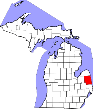 Location within the U.S. state of Michigan | |
 Michigan's location within the U.S. | |
| Coordinates: 43°28′N 82°38′W | |
| Country | |
| State | |
| Founded | September 10, 1822 (created) December 31, 1849 (organized)[1] |
| Seat | Sandusky |
| Largest city | Sandusky |
| Area | |
| • Total | 1,590 sq mi (4,100 km2) |
| • Land | 963 sq mi (2,490 km2) |
| • Water | 627 sq mi (1,620 km2) 39%% |
| Population | |
| • Estimate (2018) | 41,182 |
| • Density | 45/sq mi (17/km2) |
| Time zone | UTC−5 (Eastern) |
| • Summer (DST) | UTC−4 (EDT) |
| Congressional district | 10th |
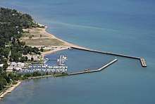
Sanilac County is considered to be part of the Thumb of Michigan, a subregion of the Flint/Tri-Cities. Sanilac County enjoys seasonal tourism in towns such as Lexington, Port Sanilac, and Carsonville. Sanilac County is economically attached to St. Clair County and Huron County and is largely composed of nearly flat areas of rich soil.
History
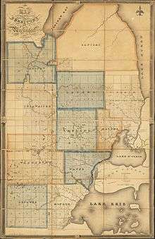
Sanilac County was probably named for a Wyandot (Huron) chief named Sanilac.[4] (See List of Michigan county name etymologies). The county was formed on September 10, 1822, by the Michigan Territorial Legislature, partitioning parts of St. Clair County and unorganized territory administered by Oakland County. The original boundary of the county was reduced in 1840, when parts were partitioned off to create Huron and Tuscola counties. The county government was fully organized on December 31, 1849.[1] In the middle of the 19th century, the area now called Port Sanilac was called Bark Shanty. It was named for a lone shanty made of bark, which was used to make shingles from pine. The county seat of Sanilac is the city of Sandusky.
Geography
According to the U.S. Census Bureau, the county has a total area of 1,590 square miles (4,100 km2), of which 963 square miles (2,490 km2) is land and 627 square miles (1,620 km2) (39%) is water.[5]
Adjacent counties
- Huron County (north)
- Tuscola County (west)
- St. Clair County (south)
- Lapeer County (southwest)
- Huron County, Ontario, Canada (east)
Demographics
| Historical population | |||
|---|---|---|---|
| Census | Pop. | %± | |
| 1850 | 2,112 | — | |
| 1860 | 7,599 | 259.8% | |
| 1870 | 14,562 | 91.6% | |
| 1880 | 26,341 | 80.9% | |
| 1890 | 32,589 | 23.7% | |
| 1900 | 35,055 | 7.6% | |
| 1910 | 33,930 | −3.2% | |
| 1920 | 31,237 | −7.9% | |
| 1930 | 27,751 | −11.2% | |
| 1940 | 30,114 | 8.5% | |
| 1950 | 30,837 | 2.4% | |
| 1960 | 32,314 | 4.8% | |
| 1970 | 34,889 | 8.0% | |
| 1980 | 40,789 | 16.9% | |
| 1990 | 39,928 | −2.1% | |
| 2000 | 44,547 | 11.6% | |
| 2010 | 43,114 | −3.2% | |
| Est. 2018 | 41,182 | [6] | −4.5% |
| US Decennial Census[7] 1790-1960[8] 1900-1990[9] 1990-2000[10] 2010-2018[2] | |||
The 2010 United States Census[11] indicates Sanilac County had a 2010 population of 43,114. This decrease of -1,433 people from the 2000 United States Census represents a 3.2% population loss in the decade. In 2010 there were 17,132 households and 11,885 families in the county. The population density was 44.8 per square mile (17.3 per km²). There were 22,725 housing units at an average density of 23.6 per square mile (9.1 per km²). 96.6% of the population were White, 0.5% Native American, 0.3% Black or African American, 0.3% Asian, 1.1% of some other race and 1.2% of two or more races. 3.3% were Hispanic or Latino (of any race). 26.1% were of German, 11.0% Polish, 10.4% English, 8.3% Irish, 7.2% American and 5.1% French, French Canadian or Cajun ancestry.[12]
There were 17,132 households out of which 29.2% had children under the age of 18 living with them, 55.3% were husband and wife families, 9.8% had a female householder with no husband present, 30.6% were non-families, and 26.4% were made up of individuals. The average household size was 2.48 and the average family size was 2.97.
In the county, the population was spread out with 23.6% under age of 18, 7.4% from 18 to 24, 21.8% from 25 to 44, 29.6% from 45 to 64, and 17.6% who were 65 years of age or older. The median age was 43 years. For every 100 females there were 97.8 males. For every 100 females age 18 and over, there were 96.7 males.
The 2010 American Community Survey 3-year estimate[11] indicates the median income for a household in the county was $39,138 and the median income for a family was $47,885. Males had a median income of $27,440 versus $16,509 for females. The per capita income for the county was $19,671. About 1.5% of families and 16.1% of the population were below the poverty line, including 23.3% of those under the age 18 and 11.4% of those age 65 or over.
Religion
- The Roman Catholic Diocese of Saginaw is the controlling regional body for the Catholic Church.[13]
- There are no meetinghouses for The Church of Jesus Christ of Latter-day Saints in the boundaries of Sanilac County.
Government
Sanilac County has voted for the Republican nominee in every presidential election since the GOP's inaugural election in 1856, except in 1912, when the county supported Theodore Roosevelt's Bull Moose Party campaign. However, they had voted for the Republican nominee in 1912, William Howard Taft in the previous election (1908). Hence, every person who has won the GOP's nomination has won Sanilac County, Michigan. Theodore Roosevelt had also been the Republican nominee in 1904.
| Year | Republican | Democratic | Third Parties |
|---|---|---|---|
| 2016 | 69.9% 13,446 | 25.3% 4,873 | 4.8% 930 |
| 2012 | 59.4% 10,963 | 39.1% 7,212 | 1.5% 275 |
| 2008 | 53.0% 10,679 | 44.9% 9,047 | 2.2% 443 |
| 2004 | 60.8% 12,632 | 38.0% 7,883 | 1.2% 248 |
| 2000 | 59.1% 10,966 | 38.5% 7,153 | 2.4% 447 |
| 1996 | 45.2% 7,821 | 41.0% 7,092 | 13.9% 2,401 |
| 1992 | 42.1% 7,891 | 31.3% 5,868 | 26.7% 4,999 |
| 1988 | 65.7% 10,653 | 33.6% 5,445 | 0.7% 109 |
| 1984 | 75.1% 12,627 | 24.5% 4,126 | 0.3% 57 |
| 1980 | 67.1% 12,158 | 27.0% 4,898 | 5.9% 1,061 |
| 1976 | 62.9% 10,597 | 35.8% 6,042 | 1.3% 217 |
| 1972 | 72.9% 11,031 | 25.0% 3,780 | 2.1% 314 |
| 1968 | 65.5% 9,273 | 22.5% 3,193 | 12.0% 1,702 |
| 1964 | 54.7% 7,590 | 45.2% 6,266 | 0.1% 18 |
| 1960 | 72.5% 11,005 | 27.4% 4,153 | 0.2% 27 |
| 1956 | 78.9% 11,095 | 21.0% 2,954 | 0.1% 17 |
| 1952 | 82.5% 11,181 | 17.0% 2,298 | 0.6% 78 |
| 1948 | 77.7% 8,237 | 20.4% 2,167 | 1.9% 202 |
| 1944 | 82.1% 9,512 | 17.4% 2,015 | 0.5% 60 |
| 1940 | 82.1% 10,289 | 17.5% 2,195 | 0.3% 43 |
| 1936 | 63.2% 6,975 | 29.8% 3,285 | 7.0% 776 |
| 1932 | 61.2% 6,860 | 36.4% 4,077 | 2.4% 268 |
| 1928 | 81.6% 7,888 | 18.0% 1,736 | 0.5% 44 |
| 1924 | 84.5% 7,767 | 10.7% 983 | 4.8% 438 |
| 1920 | 84.7% 7,256 | 13.4% 1,146 | 2.0% 169 |
| 1916 | 69.6% 4,639 | 28.0% 1,867 | 2.4% 157 |
| 1912 | 32.2% 2,166 | 17.3% 1,161 | 50.6% 3,401 |
| 1908 | 69.0% 4,173 | 24.4% 1,474 | 6.7% 404 |
| 1904 | 74.4% 4,671 | 19.4% 1,217 | 6.3% 393 |
| 1900 | 63.9% 4,173 | 31.6% 2,065 | 4.4% 289 |
| 1896 | 51.7% 3,634 | 44.9% 3,156 | 3.3% 234 |
| 1892 | 54.3% 2,494 | 37.7% 1,730 | 8.0% 366 |
| 1888 | 51.7% 2,940 | 42.8% 2,434 | 5.6% 317 |
| 1884 | 49.1% 1,923 | 46.4% 1,817 | 4.5% 177 |
The county government operates the jail, maintains rural roads, operates the major local courts, records deeds, mortgages, and vital records, administers public health regulations, and participates with the state in the provision of social services. The county board of commissioners controls the budget and has limited authority to make laws or ordinances. In Michigan, most local government functions — police and fire, building and zoning, tax assessment, street maintenance, etc. — are the responsibility of individual cities and townships.
Elected officials
- Prosecuting Attorney: James V. Young[15]
- Sheriff: Garry Biniecki
- County Clerk: Denise McGuire[16]
- County Treasurer: Trudy M. Nicol[17]
- Register of Deeds: Michele VanNorman[18]
- Drain Commissioner: Gregory L Alexander[19]
- Circuit Court Judge: Hon. Donald A. Teeple[20]
- Probate Court Judge: Hon. Gregory S. Ross[20]
- District Court Judge: Hon. Gregory S Ross[20]
- Commissioner – Dist 1: Daniel Dean
- Commissioner – Dist 2: Gary Heberling
- Commissioner – Dist 3: William Sarkella
- Commissioner – Dist 4: Bob Colely
- Commissioner – Dist 5: Paul Muxlow[21]
Media
- Sanilac/GB Broadcasting operates three radio stations in Sanilac County.
- The county is served weekly by the Tribune-Recorder since 1893, the Sanilac County News of Sandusky and other small newspapers.
- Daily deliveries of the Port Huron Times Herald are available in Sanilac County.
Communities
Cities
- Brown City
- Croswell
- Marlette
- Sandusky (county seat)
Census-designated place
Other unincorporated communities
- Amadore
- Argyle
- Austin Center
- Birch Beach
- Blue Water Beach
- Cash
- Charleston
- Cumber
- Decker
- Downington
- Elmer
- Freidberger
- Great Lakes Beach
- Huronia Heights
- Juhl
- Laing
- Lexington Heights
- McGregor
- Omard
- Palms
- Tyre
Townships
- Argyle Township
- Austin Township
- Bridgehampton Township
- Buel Township
- Custer Township
- Delaware Township
- Elk Township
- Elmer Township
- Evergreen Township
- Flynn Township
- Forester Township
- Fremont Township
- Greenleaf Township
- Lamotte Township
- Lexington Township
- Maple Valley Township
- Marion Township
- Marlette Township
- Minden Township
- Moore Township
- Sanilac Township
- Speaker Township
- Washington Township
- Watertown Township
- Wheatland Township
- Worth Township
See also
- List of Michigan State Historic Sites in Sanilac County, Michigan
- National Register of Historic Places listings in Sanilac County, Michigan
References
- Long Sanilac County
- "State & County QuickFacts". US Census Bureau. Retrieved August 29, 2013.
- "Find a County". National Association of Counties. Retrieved June 7, 2011.
- Michigan government on origin of county names
- "2010 Census Gazetteer Files". US Census Bureau. August 22, 2012. Archived from the original on November 13, 2013. Retrieved September 28, 2014.
- "Population and Housing Unit Estimates". Retrieved May 16, 2019.
- "US Decennial Census". US Census Bureau. Retrieved September 28, 2014.
- "Historical Census Browser". University of Virginia Library. Retrieved September 28, 2014.
- "Population of Counties by Decennial Census: 1900 to 1990". US Census Bureau. Retrieved September 28, 2014.
- "Census 2000 PHC-T-4. Ranking Tables for Counties: 1990 and 2000" (PDF). US Census Bureau. Retrieved September 28, 2014.
- "U.S. Census website". US Census Bureau. Retrieved March 11, 2012.
- Data Access and Dissemination Systems (DADS). "U.S. Census website". census.gov.
- "Diocese of Saginaw". saginaw.org.
- US Election Atlas
- SC Prosecuting Atty (accessed 10 September 2018)
- SC Clerk (accessed 10 September 2018)
- SC Treasurer Office (accessed 10 September 2018)
- SC Register of Deeds (accessed 10 September 2018)
- SC Drain Commissioner (accessed 10 September 2018)
- SC Courts (accessed 10 September 2018)
- SC Board of Commissioners (accessed 10 September 2018)
Further reading
- "Bibliography on Sanilac County". Clarke Historical Library, Central Michigan University. Retrieved January 29, 2013.
- John H. Long, Editor; Peggy Tuck Sinko, Associate Editor and Historical Compiler; Douglas Knox, Book Digitizing Director; Emily Kelley, Research Associate; Laura Rico-Beck, GIS Specialist and Digital Compiler; Peter Siczewicz, ArcIMS Interactive Map Designer; Robert Will, Cartographic Assistant (2007). "Michigan: Individual County Chronologies". Atlas of Historical County Boundaries. Newberry Library.
Sanilac County *10 September 1822: Sanilac County created by Michigan Territory from St. Clair and Non-County Area 2 attached to Oakland. Sanilac not fully organized, attached to Oakland for administrative and judicial purposes. (Terr. Papers U.S., 11:310-311) *12 April 1827: Sanilac detached from Oakland, attached to St. Clair "for judicial purposes." (Mich. Terr. Laws, 2:588) *28 March 1836: Part of Sanilac detached from St. Clair, attached to Lapeer "for judicial purposes." (Mich. Acts 1836, ann. sess., p. 67) *1 April 1840: Sanilac lost to creation of Huron and Tuscola. Sanilac detached from Lapeer, re-attached to St. Clair "for judicial purposes." (Mich. Acts 1840, ann. sess., no. 119, secs. 1, 4, 30, 32-34/pp. 196, 200) *3 April 1848: Sanilac gained from St. Clair. (Mich. Acts 1848, ann. sess., no. 228/p. 344) *31 December 1849: Sanilac fully organized, detached from St. Clair. (Mich. Acts 1848, ann. sess., no. 228/p. 344)
CS1 maint: uses authors parameter (link)
External links
Places adjacent to Sanilac County, Michigan | ||||||||||
|---|---|---|---|---|---|---|---|---|---|---|
| ||||||||||
Municipalities and communities of Sanilac County, Michigan, United States | ||
|---|---|---|
| Cities | Map of Michigan highlighting Sanilac County.svg | |
| Villages | ||
| Townships | ||
| CDP | ||
| Other unincorporated communities |
| |
| Former community | ||
| Footnotes | ‡This populated place also has portions in an adjacent county or counties | |
Central/Mid-Michigan including the Tri-Cities and Thumb | |||||||
|---|---|---|---|---|---|---|---|
| Central cities | |||||||
| Counties |
| ||||||
| Geography | |||||||
| Transportation | |||||||
| Economy |
| ||||||
| |||||||

| Authority control |
|
|---|