Clare County, Michigan
Clare County is a county in the U.S. state of Michigan. As of the 2010 census, the population was 30,926.[2] The county seat is Harrison.[3]
Clare County | |
|---|---|
 | |
 Seal | |
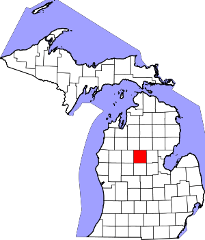 Location within the U.S. state of Michigan | |
 Michigan's location within the U.S. | |
| Coordinates: 43°59′N 84°50′W | |
| Country | |
| State | |
| Founded | 1840 (established) 1871 (organized)[1] |
| Named for | County Clare, Ireland |
| Seat | Harrison |
| Largest city | Clare |
| Area | |
| • Total | 575 sq mi (1,490 km2) |
| • Land | 564 sq mi (1,460 km2) |
| • Water | 11 sq mi (30 km2) 1.9%% |
| Population | |
| • Estimate (2018) | 30,757 |
| • Density | 55/sq mi (21/km2) |
| Time zone | UTC−5 (Eastern) |
| • Summer (DST) | UTC−4 (EDT) |
| Congressional district | 4th |
History
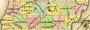
The county was created by the Michigan Legislature from part of Michilimackinac County in 1840, named Kaykakee County. It was renamed Clare County in 1843 after County Clare in Ireland. The county was administered by a succession of other Michigan counties prior to the organization of county government in 1871.[4][1][5][lower-alpha 1] Farwell was the first county seat; in 1877 the county seat was moved to Harrison.
Geography
According to the US Census Bureau, the county has a total area of 575 square miles (1,490 km2), of which 564 square miles (1,460 km2) is land and 11 square miles (28 km2) (1.9%) is water.[6] It is considered to be part of both Northern Michigan and Central Michigan.
Features
Major highways


Adjacent counties
- Missaukee County – northwest
- Roscommon County – northeast
- Gladwin County – east
- Midland County – southeast
- Isabella County – south
- Mecosta County – southwest
- Osceola County – west
Demographics
| Historical population | |||
|---|---|---|---|
| Census | Pop. | %± | |
| 1870 | 366 | — | |
| 1880 | 4,187 | 1,044.0% | |
| 1890 | 7,558 | 80.5% | |
| 1900 | 8,360 | 10.6% | |
| 1910 | 9,240 | 10.5% | |
| 1920 | 8,250 | −10.7% | |
| 1930 | 7,032 | −14.8% | |
| 1940 | 9,163 | 30.3% | |
| 1950 | 10,253 | 11.9% | |
| 1960 | 11,647 | 13.6% | |
| 1970 | 16,695 | 43.3% | |
| 1980 | 23,822 | 42.7% | |
| 1990 | 24,952 | 4.7% | |
| 2000 | 31,252 | 25.2% | |
| 2010 | 30,926 | −1.0% | |
| Est. 2018 | 30,757 | [8] | −0.5% |
| US Decennial Census[9] 1790-1960[10] 1900-1990[11] 1990-2000[12] 2010-2018[2] | |||
The 2010 United States Census[13] indicates Clare County had a 2010 population of 30,926. This decrease of 326 people from the 2000 United States Census represents a loss of 1.0% population. In 2010 there were 12,966 households and 8,584 families in the county. The population density was 54.8 per square mile (21.2 per km²). There were 23,233 housing units at an average density of 41.2 per square mile (15.9 per km²). The racial and ethnic makeup of the county was 95.8% White, 0.5% Black or African American, 0.6% Native American, 0.3% Asian, 1.5% Hispanic or Latino, 0.1% from other races, and 1.3% from two or more races.
There were 12,966 households out of which 25.3% had children under the age of 18 living with them, 51.0% were husband and wife families, 10.0% had a female householder with no husband present, 33.8% were non-families, and 28.0% were made up of individuals. The average household size was 2.36 and the average family size was 2.83.
The county population contained 20.9% under age of 18, 7.9% from 18 to 24, 20.8% from 25 to 44, 30.4% from 45 to 64, and 19.9% who were 65 years of age or older. The median age was 45 years. For every 100 females there were 99.7 males. For every 100 females age 18 and over, there were 97.9 males.
The 2010 American Community Survey 3-year estimate[13] indicates the median income for a household in the county was $33,338 and the median income for a family was $40,983. Males had a median income of $24,220 versus $13,587 for females. The per capita income for the county was $18,516. About 2.3% of families and 23.1% of the population were below the poverty line, including 36.8% of those under the age 18 and 8.5% of those age 65 or over.
Religion
- The Roman Catholic Diocese of Saginaw is the controlling regional body for the Catholic Church.[14]
- The Church of Jesus Christ of Latter-day Saints has one meetinghouse in the county, in Harrison.[15]
Government
Clare County voters tend to vote Republican; they have selected the Republican Party nominee in 71% of national elections (24 of 34).
| Year | Republican | Democratic | Third Parties |
|---|---|---|---|
| 2016 | 63.2% 8,505 | 31.6% 4,249 | 5.2% 695 |
| 2012 | 51.6% 6,988 | 46.8% 6,338 | 1.5% 209 |
| 2008 | 46.5% 6,793 | 51.3% 7,496 | 2.2% 316 |
| 2004 | 49.8% 7,088 | 49.1% 6,984 | 1.1% 154 |
| 2000 | 47.1% 5,937 | 49.9% 6,287 | 3.0% 383 |
| 1996 | 32.0% 3,742 | 54.0% 6,311 | 14.0% 1,630 |
| 1992 | 32.2% 3,916 | 44.0% 5,346 | 23.9% 2,901 |
| 1988 | 54.2% 5,661 | 45.1% 4,710 | 0.7% 77 |
| 1984 | 63.3% 6,587 | 36.2% 3,764 | 0.6% 61 |
| 1980 | 53.4% 5,719 | 38.9% 4,164 | 7.8% 835 |
| 1976 | 53.5% 4,879 | 45.5% 4,153 | 1.0% 94 |
| 1972 | 63.0% 4,402 | 34.8% 2,434 | 2.2% 152 |
| 1968 | 56.9% 3,315 | 32.7% 1,909 | 10.4% 607 |
| 1964 | 43.5% 2,258 | 56.3% 2,927 | 0.2% 12 |
| 1960 | 70.5% 3,616 | 29.4% 1,507 | 0.1% 7 |
| 1956 | 75.5% 3,721 | 24.2% 1,194 | 0.3% 13 |
| 1952 | 76.2% 3,529 | 22.9% 1,059 | 0.9% 42 |
| 1948 | 66.0% 2,512 | 31.5% 1,197 | 2.5% 96 |
| 1944 | 70.6% 2,636 | 28.9% 1,078 | 0.6% 21 |
| 1940 | 69.9% 3,004 | 29.7% 1,277 | 0.4% 19 |
| 1936 | 53.4% 1,979 | 40.3% 1,494 | 6.3% 235 |
| 1932 | 44.3% 1,474 | 52.4% 1,741 | 3.3% 109 |
| 1928 | 82.6% 1,920 | 16.4% 381 | 1.0% 23 |
| 1924 | 77.7% 1,920 | 14.5% 358 | 7.9% 194 |
| 1920 | 73.5% 1,762 | 21.3% 511 | 5.2% 125 |
| 1916 | 54.4% 1,049 | 39.9% 769 | 5.8% 111 |
| 1912 | 31.0% 563 | 23.9% 435 | 45.1% 819 |
| 1908 | 68.1% 1,345 | 28.7% 567 | 3.1% 62 |
| 1904 | 70.9% 1,453 | 25.3% 519 | 3.8% 77 |
| 1900 | 63.6% 1,182 | 34.5% 640 | 1.9% 36 |
| 1896 | 53.1% 886 | 43.3% 723 | 3.6% 60 |
| 1892 | 41.9% 719 | 47.3% 811 | 10.8% 186 |
| 1888 | 48.0% 905 | 48.4% 912 | 3.7% 69 |
| 1884 | 46.2% 622 | 50.9% 685 | 2.9% 39 |
The county government operates the jail, maintains rural roads, operates the major local courts, records deeds, mortgages, and vital records, administers public health regulations, and participates with the state in the provision of social services. The county board of commissioners controls the budget and has limited authority to make laws or ordinances. In Michigan, most local government functions — police and fire, building and zoning, tax assessment, street maintenance, etc. — are the responsibility of individual cities and townships.
Elected officials
- County Commission: Dale Majewski; Samantha Pitchford; Leonard Strouse; Jack Kleinhardt; Mark Fitzpatrick; David Hoefling; Jeff Haskell
- Prosecuting Attorney: Michelle Ambrozaitis
- Sheriff: John Wilson
- County Clerk/Register of Deeds: Lori Martin
- County Treasurer: Jenny Beemer-Fritzinger
- Drain Commissioner: Carl Parks
- County Surveyor: Paul A. Lapham
- Road Commission: Richard Haynak; Tim Haskin; Karen Hulliberger
- State Representative: Jason Wentworth
(information as of January 2019)
Attractions
Clare County is in the middle of large state forests. Wildlife, including bear, deer, eagles, Kirtland's warblers, and turkeys, are located nearby. Local attractions include:
- Kirtland's Warbler Habitat and Festival[17]
- Michigan Shore-to-Shore Trail passes through the area, running from Empire to Oscoda and points beyond. It is a 500-mile interconnected system of trails.[18]
Activities include:
- Birding
- Boating
- Fishing
- Hiking
- Hunting
- Nordic skiing
- ORV and groomed snowmobile trails.
- Paddling (canoe and kayak)
Communities
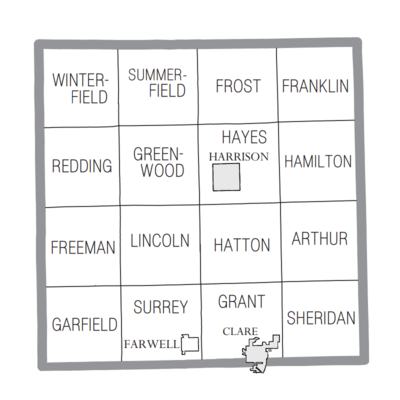
Cities
- Clare (partial)
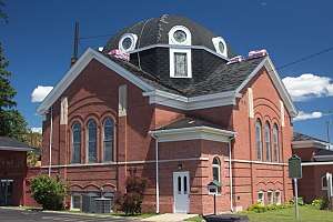
- Harrison (county seat)
Village
Civil townships
Unincorporated communities
See also
- List of Michigan State Historic Sites in Clare County, Michigan
- National Register of Historic Places listings in Clare County, Michigan
Notes
- For more details on Michigan county names and etymologies, see List of counties in Michigan.
References
- "Bibliography on Clare County". Clarke Historical Library, Central Michigan University. Retrieved November 4, 2016.
- "State & County QuickFacts". US Census Bureau. Retrieved August 27, 2013.
- "Find a County". National Association of Counties. Archived from the original on May 31, 2011. Retrieved June 7, 2011.
- Newberry Library. "Michigan: Individual County Chronologies". Atlas of County Historical Boundaries. Retrieved November 4, 2016.
- Michigan History, Arts and Libraries on sources of County names. Archived July 28, 2009, at the Wayback Machine
- "2010 Census Gazetteer Files". US Census Bureau. August 22, 2012. Archived from the original on November 13, 2013. Retrieved September 19, 2014.
- Clare County MI Google Maps (accessed 6 September 2018)
- "Population and Housing Unit Estimates". Retrieved May 16, 2019.
- "US Decennial Census". US Census Bureau. Retrieved September 19, 2014.
- "Historical Census Browser". University of Virginia Library. Retrieved September 19, 2014.
- "Population of Counties by Decennial Census: 1900 to 1990". US Census Bureau. Retrieved September 19, 2014.
- "Census 2000 PHC-T-4. Ranking Tables for Counties: 1990 and 2000" (PDF). US Census Bureau. Retrieved September 19, 2014.
- "U.S. Census website". US Census Bureau. Retrieved March 11, 2012.
- "Diocese of Saginaw".
- Meetinghouse Locator LDS.org (accessed 6 September 2018)
- US Election Atlas
- "Kirtland". kirtland.edu. May 13, 2014. Archived from the original on January 2, 2008.
- Michigan Shore to Shore Riding and Hiking Trail
External links
Official Visitor Information Site
- Clare County Convention & Visitors Bureau
- The Clare County Chamber of Commerce
- The Clare County Business Association Website
News from Clare County
- The Clare County Review - Local newspaper
- Clare County government
- Clare Sentinel Newspaper Online via Clarke Historical Library and Central Michigan University
Places adjacent to Clare County, Michigan | ||||||||||
|---|---|---|---|---|---|---|---|---|---|---|
| ||||||||||
Municipalities and communities of Clare County, Michigan, United States | ||
|---|---|---|
| Cities | Map of Michigan highlighting Clare County.svg | |
| Village | ||
| Civil townships | ||
| Unincorporated communities | ||
| Footnotes | ‡This populated place also has portions in an adjacent county or counties | |
| Central cities | |
|---|---|
| Counties | |
| Geography | |
| Transportation | |
| Economy | |
| |
Central/Mid-Michigan including the Tri-Cities and Thumb | |||||||
|---|---|---|---|---|---|---|---|
| Central cities | |||||||
| Counties |
| ||||||
| Geography | |||||||
| Transportation | |||||||
| Economy |
| ||||||
| |||||||

| Authority control |
|
|---|