Houghton County, Michigan
Houghton County is a county in the Upper Peninsula in the U.S. state of Michigan. As of the 2010 census, the population was 36,628.[2] The county seat and largest city is Houghton.[3][4] Both the county and the city were named for Michigan State geologist and Detroit Mayor Douglass Houghton.[5][3]
Houghton County | |
|---|---|
 Houghton County Courthouse | |
Seal | |
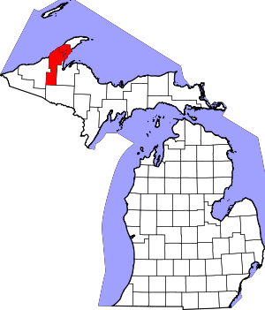 Location within the U.S. state of Michigan | |
 Michigan's location within the U.S. | |
| Coordinates: 46°59′N 88°39′W | |
| Country | |
| State | |
| Founded | 1843 (set off) 1845 (boundaries described) 1846 (organized) 1848 (re-organized)[1] |
| Named for | Douglass Houghton |
| Seat | Houghton |
| Largest city | Houghton |
| Area | |
| • Total | 1,502 sq mi (3,890 km2) |
| • Land | 1,009 sq mi (2,610 km2) |
| • Water | 492 sq mi (1,270 km2) 33%% |
| Population | |
| • Estimate (2018) | 36,219 |
| • Density | 36/sq mi (14/km2) |
| Time zone | UTC−5 (Eastern) |
| • Summer (DST) | UTC−4 (EDT) |
| Congressional district | 1st |
Houghton County is part of the Houghton Micropolitan Statistical Area, which also includes Keweenaw County, and was part of Copper Country during the mining boom of the latter half of the 19th century and the early part of the 20th century.
Geography
According to the U.S. Census Bureau, the county has an area of 1,502 square miles (3,890 km2), of which 1,009 square miles (2,610 km2) is land and 492 square miles (1,270 km2) (33%) is water.[6]
The Portage Lift Bridge crosses Portage Lake, connecting Hancock and Houghton, Michigan, by crossing over Portage Lake, which is part of the river and canal system that spans the peninsula. The Portage Lift Bridge is the world's heaviest and widest double-decked vertical lift bridge. Its center span "lifts" to provide 100 feet (30 m) of clearance for ships. Since rail traffic was discontinued in the Keweenaw, the lower deck accommodates snowmobile traffic in the winter. This is the only land-based link between the Keweenaw Peninsula's north and south sections, making it crucial to local transportation.[7]
Major highways


Airport
- Prickett-Grooms Field (FAA LID: 6Y9) privately-owned public-use general-aviation daytime-access airport at Sidnaw (since 1940s).
- Houghton County Memorial Airport (KCMX) between Hancock and Calumet (since 1948). General-aviation and limited commercial airline service.
Adjacent counties
- Keweenaw County, north
- Baraga County, east
- Iron County, south border (on Central Time Zone)
- Ontonagon County, west
National protected areas
- Keweenaw National Historical Park (part)
- Ottawa National Forest (part)
Climate
| ||||||||||||||||||||||||||||||||||||||||||||||||||||||||||||||||||||||||||||||||||||||||||||||||||||||||||||||||||||||||||||
Demographics
| Historical population | |||
|---|---|---|---|
| Census | Pop. | %± | |
| 1850 | 708 | — | |
| 1860 | 9,234 | 1,204.2% | |
| 1870 | 13,879 | 50.3% | |
| 1880 | 22,473 | 61.9% | |
| 1890 | 35,389 | 57.5% | |
| 1900 | 66,063 | 86.7% | |
| 1910 | 88,098 | 33.4% | |
| 1920 | 71,930 | −18.4% | |
| 1930 | 52,851 | −26.5% | |
| 1940 | 47,631 | −9.9% | |
| 1950 | 39,771 | −16.5% | |
| 1960 | 35,654 | −10.4% | |
| 1970 | 34,652 | −2.8% | |
| 1980 | 37,872 | 9.3% | |
| 1990 | 35,446 | −6.4% | |
| 2000 | 36,016 | 1.6% | |
| 2010 | 36,628 | 1.7% | |
| Est. 2018 | 36,219 | [9] | −1.1% |
| US Decennial Census[10] 1790-1960[11] 1900-1990[12] 1990-2000[13] 2010-2018[2] | |||
The 2010 United States Census[14] indicates Houghton County had a population of 36,628. This is an increase of 612 people from 2000, a growth of 1.7%. In 2010 there were 14,232 households and 8,093 families in the county. The population density was 36 people per square mile (14/km²). There were 18,635 housing units at an average density of 18 per square mile (7/km²). 94.5% of the population were White, 2.9% Asian, 0.6% Native American, 0.5% Black or African American, 0.2% of some other race and 1.3% of two or more races. 1.1% were Hispanic or Latino (of any race). 32.5% were of Finnish, 14.0% German, 9.4% French, 6.2% English and 5.1% Irish ancestry.[15]
There were 14,232 households out of which 23.4% had children under the age of 18 living with them, 45% were married couples living together, 7.7% had a female householder with no husband present, and 43.1% were non-families. 32.2% of all households were made up of individuals and 12.6% had someone living alone who was 65 years of age or older. The average household size was 2.38 and the average family size was 3.01.[14]
The county population contained 20.6% under the age of 18, 20.6% from 18 to 24, 20.3% from 25 to 44, 23.6% from 45 to 64, and 15% who were 65 years of age or older. The median age was 33.1 years. The population was 45.9% female and 54.1% male.
The median income for a household in the county was $34,625, and the median income for a family was $48,506. The per capita income for the county was $18,556. About 12.6% of families and 22.8% of the population were below the poverty line, including 21.7% of people under the age of 18 and 9.2% of those age 65 or over.
History
In 1843, the Upper Peninsula was divided into Mackinac, Chippewa, Marquette, Schoolcraft, Delta, and Ontonagon Counties.[16] In 1845, Houghton County boundaries were defined, with areas partitioned from Marquette and Ontonagon Counties. The new county was named after Douglass Houghton, the new state's first State Geologist, who extensively explored the Upper Peninsula's mineralogy.[16][17] The original boundaries of Houghton County included the future Keweenaw and Baraga Counties.[18] In 1846, the county was organized into three townships: Eagle Harbor, Houghton, and L'Anse.[18] Keweenaw County was set off from Houghton County in 1861 and Baraga County was set off in 1875.[19]
Houghton County's history is heavily marked by immigration. At one of the peaks of its population, the 1910 census had 40.6% of its population of 88,098 as foreign-born, with 89.3% of the population being either foreign-born or having at one or both of their parents as foreign-born. 70.6% of all voters were foreign-born, and only 5.1% of voters were native-born with native parents. This amalgam of immigrants from dozens of countries created a unique culture, especially once population growth stopped, and the county shrank in population to its current numbers. Heavily representative among many ethnicities were the Finnish. The 1910 census listed 13.1% of the residents being Finnish-born (out of the 32.3% total of the residents listed as foreign-born). The 2010 census lists almost the same proportion (32.5%) of the population as having Finnish ancestors.[20]
Amid the Great Depression of the 1930s, a sharp increase in unemployment among workers in the mining and timber industries caused a pivot to potato production. For a brief time in the 1930s and 1940s, the region became a major exporter of potatoes within the United States.[21]
In June 2018, a major flash flood caused sinkholes and washouts in the towns of Chassell, Houghton, Ripley, Lake Linden, and Hubbell.[22]
Government
Houghton County voters tend to favor Republican Party nominees. Since 1884, the Republican Party has been selected in 76% (26 of 34) of national elections.
| Year | Republican | Democratic | Third parties |
|---|---|---|---|
| 2016 | 53.8% 8,475 | 38.2% 6,018 | 8.1% 1,268 |
| 2012 | 53.4% 8,196 | 44.3% 6,801 | 2.4% 364 |
| 2008 | 50.7% 8,101 | 46.8% 7,476 | 2.5% 395 |
| 2004 | 56.1% 8,889 | 42.5% 6,731 | 1.5% 231 |
| 2000 | 55.5% 7,895 | 40.0% 5,688 | 4.5% 633 |
| 1996 | 43.5% 5,941 | 43.6% 5,957 | 13.0% 1,773 |
| 1992 | 36.7% 5,575 | 43.2% 6,558 | 20.0% 3,040 |
| 1988 | 51.8% 7,098 | 47.5% 6,510 | 0.6% 86 |
| 1984 | 57.1% 8,652 | 42.5% 6,434 | 0.4% 55 |
| 1980 | 47.9% 7,926 | 41.5% 6,858 | 10.6% 1,750 |
| 1976 | 51.6% 8,049 | 47.1% 7,352 | 1.3% 199 |
| 1972 | 58.1% 9,053 | 41.1% 6,402 | 0.9% 135 |
| 1968 | 46.9% 6,639 | 49.4% 6,988 | 3.6% 516 |
| 1964 | 34.0% 5,024 | 66.0% 9,761 | 0.0% 6 |
| 1960 | 49.1% 7,767 | 50.7% 8,021 | 0.2% 34 |
| 1956 | 58.3% 9,620 | 41.6% 6,866 | 0.2% 25 |
| 1952 | 59.6% 10,563 | 40.0% 7,100 | 0.4% 70 |
| 1948 | 54.6% 9,541 | 39.6% 6,925 | 5.8% 1,005 |
| 1944 | 47.4% 9,110 | 52.3% 10,066 | 0.3% 62 |
| 1940 | 50.3% 11,030 | 49.3% 10,815 | 0.4% 81 |
| 1936 | 44.1% 9,345 | 54.9% 11,642 | 1.0% 219 |
| 1932 | 59.2% 12,308 | 37.7% 7,838 | 3.1% 634 |
| 1928 | 62.3% 11,240 | 36.4% 6,573 | 1.3% 229 |
| 1924 | 83.0% 13,833 | 6.3% 1,045 | 10.7% 1,784 |
| 1920 | 80.2% 14,938 | 16.6% 3,088 | 3.2% 599 |
| 1916 | 60.2% 8,013 | 34.7% 4,615 | 5.2% 688 |
| 1912 | 29.2% 3,571 | 19.5% 2,385 | 51.3% 6,282 |
| 1908 | 73.0% 9,352 | 18.9% 2,424 | 8.0% 1,028 |
| 1904 | 78.4% 8,857 | 13.0% 1,471 | 8.6% 965 |
| 1900 | 73.4% 8,019 | 22.2% 2,422 | 4.5% 486 |
| 1896 | 71.9% 6,141 | 23.4% 1,996 | 4.8% 410 |
| 1892 | 45.8% 3,316 | 36.0% 2,607 | 18.1% 1,311 |
| 1888 | 51.1% 3,012 | 45.8% 2,696 | 3.1% 184 |
| 1884 | 57.9% 2,383 | 41.2% 1,694 | 1.0% 39 |
The county government operates the jail, maintains rural roads, operates the major local courts, records deeds, mortgages, and vital records, administers public health regulations, and participates with the state in the provision of social services. The county board of commissioners controls the budget and has limited authority to make laws or ordinances. In Michigan, most local government functions—police and fire, building and zoning, tax assessment, street maintenance, etc.—are the responsibility of individual cities and townships.
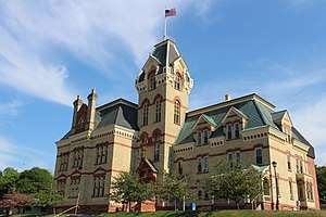
The Houghton County Courthouse "..stood high upon the bluff on Houghton Village facing North and pleasantly overlooking Portage Lake.", and has been inducted in the US Registry of Historic Districts and Buildings of the Upper Peninsula. Construction began in spring 1886. The building had its first addition to the north wing, the addition of a larger jail wing, in 1910, and that was the only renovation until the jail wing was condemned in 1961. A new jail was built in its present location, adjacent to the original. According to the Mining Gazette, "The materials used with the exception of the facing brick are the product of the Upper Peninsula" (July 25, 1886, p. 3). Kathryn Eckert, in her Buildings of Michigan, wrote:
- "The courthouse is composed of the original structure, a rectangular block from which project central pavilions with parapeted dormers, a four-story tower, and north and west wing additions. The curbed mansard roof, the grouping of windows beneath red sandstone lintels connected by bands that encircle the structure, and the decorative entablature unite the composition. Porches supported with posts and Gothic-arch brackets...The interior is richly finished with wood; red, rich brown, and light yellowish brown floor tiles; ornamental plaster; and oak staircase; and stone fireplaces." (p. 464)
The building section that was once the jail wing is now used for office space.
Elected officials
- Prosecuting Attorney: Michael E. Makinen
- Sheriff: Brian J. McLean
- County Clerk/Register of Deeds: Jennifer Lorenz
- County Treasurer: Kathleen A. Beattie
- Drain Commissioner: John Pekkala
- Mine Inspector: Murray Giles
(information as of Sept 2018)[24]
Communities
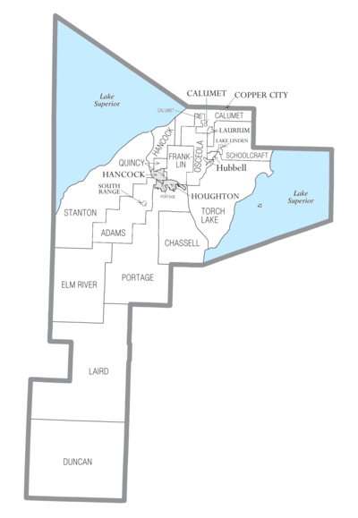
Villages
Charter townships
Civil townships
Census-designated places
Other unincorporated communities
- Atlantic Mine
- Blue Jacket
- Centennial
- Chassell
- Dakota Heights
- Dodgeville
- Donken
- Dreamland
- Franklin Mine
- Freda
- Hurontown
- Jacobsville
- Kearsarge
- Mason
- Painesdale
- Redridge
- Ripley
- Senter
- Tamarack City
- Toivola
- Trimountain
- Twin Lakes
- White City
- Yellow Jacket
See also
- List of Michigan State Historic Sites in Houghton County, Michigan
- National Register of Historic Places listings in Houghton County, Michigan
- Robert T. Brown Nature Sanctuary
References
- "Bibliography on Houghton County". Clarke Historical Library, Central Michigan University. Retrieved September 12, 2018.
- "State & County QuickFacts". U.S. Census Bureau. Retrieved August 27, 2013.
- Monette, Clarence J. (1975). Some Copper Country Names And Places. Lake Linden, Michigan. ISBN 0-942363-04-3.
- "Find a County". National Association of Counties. Retrieved June 7, 2011.
- "Encyclopedia of Detroit". Detroit Historical Society. 2020.
- "2010 Census Gazetteer Files". US Census Bureau. August 22, 2012. Retrieved September 25, 2014.
- "Keweenaw Michigan field trip". minsocam.org.
- "NASA Earth Observations Data Set Index". NASA. Retrieved January 30, 2016.
- "Population and Housing Unit Estimates". Retrieved May 16, 2019.
- "US Decennial Census". US Census Bureau. Retrieved September 25, 2014.
- "Historical Census Browser". University of Virginia Library. Retrieved September 25, 2014.
- "Population of Counties by Decennial Census: 1900 to 1990". US Census Bureau. Retrieved September 25, 2014.
- "Census 2000 PHC-T-4. Ranking Tables for Counties: 1990 and 2000" (PDF). US Census Bureau. Retrieved September 25, 2014.
- "U.S. Census website". Retrieved July 6, 2013.
- Data Access and Dissemination Systems (DADS). "U.S. Census website".
- Sawyer, p. 466
- "Houghton County Bibliography" (PDF). Library of Michigan.
- Sawyer, p. 467
- Sawyer, p. 468
- "US Decennial Census". US Census Bureau. Retrieved February 21, 2017.
- "Houghton County Potato Farming – Michigan Tech Archives Blog". April 4, 2012. Retrieved May 18, 2020.
- Powell, Mariah (June 17, 2018). "Floods Devastate Houghton Business District". Upper Michigan's Source. Negaunee MI: WLUC-TV.
- Leip, David. "Dave Leip's Atlas of U.S. Presidential Elections".
- "Houghton County Directory". Retrieved September 12, 2018.
- Sawyer, Alvah Littlefield (1911). A History of the Northern Peninsula of Michigan and Its People. Lewis Publishing Co.CS1 maint: ref=harv (link)
- Romig, Walter (1986) [1973]. Michigan Place Names: The History of the Founding and the Naming of More than Five Thousand Past and Present Michigan Communities. Great Lakes Books. Detroit: Wayne State University Press. ISBN 978-0814318386.
External links
- HoughtonCounty website
- Houghton County Sheriff's Office
- Houghton County Profile, Sam M Cohodas Regional Economist
- Township Locator Map
- Western Upper Peninsula Planning & Development Region
Places adjacent to Houghton County, Michigan | ||||||||||
|---|---|---|---|---|---|---|---|---|---|---|
| ||||||||||
Municipalities and communities of Houghton County, Michigan, United States | ||
|---|---|---|
| Cities | Map of Michigan highlighting Houghton County.svg | |
| Villages | ||
| Charter townships | ||
| Civil townships | ||
| CDPs | ||
| Other unincorporated communities |
| |
| Central cities | |
|---|---|
| Counties | |
| Geography | |
| Transportation | |
| Economy | |

| Authority control |
|
|---|