Macomb County, Michigan
Macomb County is a county located in the eastern portion of the U.S. state of Michigan and is part of northern Metro Detroit. As of the 2010 census, the population was 840,978, making it the third-most populous county in the state.[3] The county seat is Mt. Clemens.[4]
Macomb County | |
|---|---|
 | |
 Seal | |
 Location within the U.S. state of Michigan | |
 Michigan's location within the U.S. | |
| Coordinates: 42°40′N 82°55′W | |
| Country | |
| State | |
| Founded | January 15, 1818[1][2] |
| Named for | Alexander Macomb |
| Seat | Mount Clemens |
| Largest city | Warren |
| Area | |
| • Total | 571 sq mi (1,480 km2) |
| • Land | 479 sq mi (1,240 km2) |
| • Water | 92 sq mi (240 km2) 16%% |
| Population | |
| • Estimate (2019) | 873,972 |
| • Density | 1,819/sq mi (702/km2) |
| Time zone | UTC−5 (Eastern) |
| • Summer (DST) | UTC−4 (EDT) |
| Congressional districts | 9th, 10th |
| Website | macombgov |
Macomb County is part of the Detroit-Warren-Dearborn, MI Metropolitan Statistical Area. The city of Detroit is located south of 8 Mile Road, the county's southern border.
Macomb County contains 27 cities, townships and villages, including three of the top ten most populous municipalities in Michigan as of the 2010 census: Warren (#3), Sterling Heights (#4) and Clinton Township (#10). Most of this population is concentrated south of Hall Road (M-59), one of the county's main thoroughfares.
History
The Ojibwe lived in the area for centuries before European contact, and were preceded by other cultures of ancient indigenous peoples.
The first European explorers were French, and they arrived in the area during the 17th century. Other early settlers were French fur trappers, who sometimes married Ojibwe women, and Jesuit missionaries. A Moravian colony was established in the county in the late 18th century. In addition to the original French and English settlers, later immigrants included Germans, Belgians, and others from Europe. In the 19th century the county received many American migrants from New York and New England, who were attracted to the area for land and booming jobs in the lumber and other resource industries.[5]
Macomb County was formally organized on January 15, 1818 as the third county in the Michigan Territory. The county was named in honor of Detroit-born Alexander Macomb, Jr., a highly decorated veteran of the War of 1812 and hero of the Battle of Plattsburg. He was made Commanding General of the U.S. Army in 1828.[1][6] As was typical in development, the county at first encompassed a much larger area than at present. As population increased in the area, the state legislature removed territory in 1819 and 1820 to form the counties of Oakland, Lapeer, Genesee, and St. Clair.[1]
In May 2008, Macomb County voters approved a new charter to include a new elected position of County Executive, to be elected at-large; the proposal was to be submitted to the voters by 2010. A charter commission was elected in November 2008 for the purpose of drafting a charter for submission to the governor; after state approval, the initiative was placed on the November 2009 ballot. The Charter passed with a 60.4% to 39.6% margin.[7] Mark Hackel was voted in as Macomb's first county executive.[8]
Geography
According to the U.S. Census Bureau, the county has a total area of 571 square miles (1,480 km2), of which 479 square miles (1,240 km2) is land and 92 square miles (240 km2) (16%) is water.[9] The county's southeastern border with Canada is located across Lake St. Clair.
Lake St. Clair borders the county on the east.
Far northern parts of the county, such as Richmond and Armada, are often considered to be part of Michigan's Thumb region.
Adjacent counties
- Lambton County, Ontario, Canada - southeast
- St. Clair County, Michigan - northeast
- Lapeer County, Michigan - northwest
- Oakland County, Michigan - west
- Wayne County, Michigan - south
Demographics
| Historical population | |||
|---|---|---|---|
| Census | Pop. | %± | |
| 1810 | 580 | — | |
| 1820 | 898 | 54.8% | |
| 1830 | 2,413 | 168.7% | |
| 1840 | 9,716 | 302.7% | |
| 1850 | 15,530 | 59.8% | |
| 1860 | 22,843 | 47.1% | |
| 1870 | 27,616 | 20.9% | |
| 1880 | 31,627 | 14.5% | |
| 1890 | 31,813 | 0.6% | |
| 1900 | 33,244 | 4.5% | |
| 1910 | 32,606 | −1.9% | |
| 1920 | 38,103 | 16.9% | |
| 1930 | 77,146 | 102.5% | |
| 1940 | 107,638 | 39.5% | |
| 1950 | 184,961 | 71.8% | |
| 1960 | 405,804 | 119.4% | |
| 1970 | 625,309 | 54.1% | |
| 1980 | 694,600 | 11.1% | |
| 1990 | 717,400 | 3.3% | |
| 2000 | 788,149 | 9.9% | |
| 2010 | 840,978 | 6.7% | |
| Est. 2019 | 873,972 | [10] | 3.9% |
| U.S. Decennial Census[11] 1790-1960[12] 1900-1990[13] 1990-2000[14] 2010-2019[3] | |||
As of the 2010 United States Census, there were 840,978 people living in the county. 85.4% were White, 8.6% Black or African American, 3.0% Asian, 0.3% Native American, 0.6% of some other race and 2.1% of two or more races. 2.3% were Hispanic or Latino (of any race). 14.8% were of German, 14.3% Polish, 11.1% Italian, 6.5% Irish and 5.9% American ancestry.[15]
In 2000, 87.6% of county residents spoke only English at home; 1.7% spoke Italian, 1.4% Polish, 1.2% Spanish, 1.1% Arabic, and 1.1% Syriac.
Among Asian ethnic groups, six numbered over 1,000 people in Macomb County. The most numerous were the 5,713 Southeast Asian Indians, followed by Filipinos (4,155), Chinese (2,489), Koreans (1,853) Vietnamese (1,557), and Hmong (1,103).[16] Pakistanis are also represented in Macomb County's population.[17]
European and Mid-Eastern national and ethnic groups that have settled in Macomb County since the 20th century include Albanians, Arabs, Chaldeans and Macedonians.[17]
Native American tribes had over 2,478 residents in Macomb County in 2000.[18]
In 2000, there were 309,203 households out of which 31.10% had children under the age of 18 living with them, 54.30% were married couples living together, 10.10% had a female householder with no husband present, and 31.80% were non-families. 26.90% of all households were made up of individuals and 10.30% had someone living alone who was 65 years of age or older. The average household size was 2.52 and the average family size was 3.09.[18]
In 2000, the age distribution of the county was as follows: 24.10% under the age of 18, 8.00% from 18 to 24, 31.50% from 25 to 44, 22.80% from 45 to 64, and 13.70% who were 65 years of age or older. The median age was 37 years. For every 100 females, there were 96.00 males. For every 100 females age 18 and over, there were 92.90 males.[18]
The median income for a household in the county was $52,102, and the median income for a family was $62,816. Males had a median income of $48,303 versus $30,215 for females. The per capita income for the county was $24,446. About 4.00% of families and 5.60% of the population were below the poverty line, including 7.00% of those under age 18 and 6.40% of those age 65 or over.[18]
According to the 2006 American Community Survey the average family size was 3.15. The population of 25 and over was 571,463. 86.9% of that population had graduated from high school, and 21% of the population had a Bachelor's degree or higher. About 14.3% of that population was disabled. 12.5% of Macomb's population could speak another language at home.[18]
Of Michigan's five largest counties, Macomb experienced the most population growth (102.5%) between 1950 and 1960.
Parks and recreation
Macomb County is home to more than 130 parks covering 12,000 acres (49 km2) managed by the state, regional, county, and local government. There are four major public parks in the County - Freedom Hill County Park, Macomb Orchard Trail, Lake St. Clair Metropark, and Stony Creek Metropark. The county also has 31 miles of shoreline and over 100 marinas.[19]
Government
| Year | Republican | Democratic | Third Parties |
|---|---|---|---|
| 2016 | 53.6% 224,665 | 42.1% 176,317 | 4.4% 18,330 |
| 2012 | 47.3% 191,913 | 51.3% 208,016 | 1.4% 5,586 |
| 2008 | 44.7% 187,663 | 53.3% 223,784 | 2.1% 8,729 |
| 2004 | 50.2% 202,166 | 48.8% 196,160 | 1.0% 4,084 |
| 2000 | 47.5% 164,265 | 50.0% 172,625 | 2.5% 8,669 |
| 1996 | 39.4% 120,616 | 49.5% 151,430 | 11.1% 33,982 |
| 1992 | 42.3% 147,795 | 37.4% 130,732 | 20.3% 70,711 |
| 1988 | 60.3% 175,632 | 38.8% 112,856 | 0.9% 2,627 |
| 1984 | 66.2% 194,300 | 33.3% 97,816 | 0.5% 1,409 |
| 1980 | 51.9% 154,155 | 40.4% 120,125 | 7.7% 22,839 |
| 1976 | 51.2% 132,499 | 46.9% 121,176 | 1.9% 4,928 |
| 1972 | 62.7% 147,777 | 34.9% 82,346 | 2.4% 5,670 |
| 1968 | 30.4% 63,139 | 55.2% 114,552 | 14.4% 29,886 |
| 1964 | 25.3% 44,684 | 74.5% 131,450 | 0.2% 387 |
| 1960 | 36.9% 61,989 | 62.8% 105,681 | 0.3% 525 |
| 1956 | 48.1% 58,337 | 51.7% 62,816 | 0.2% 266 |
| 1952 | 50.4% 37,474 | 49.1% 36,544 | 0.5% 346 |
| 1948 | 44.5% 21,205 | 53.0% 25,265 | 2.5% 1,190 |
| 1944 | 47.2% 21,305 | 52.1% 23,506 | 0.7% 324 |
| 1940 | 45.7% 17,848 | 53.8% 21,003 | 0.5% 203 |
| 1936 | 32.0% 9,383 | 60.1% 17,593 | 7.9% 2,323 |
| 1932 | 33.3% 8,649 | 63.7% 16,539 | 3.1% 796 |
| 1928 | 63.3% 12,845 | 36.3% 7,363 | 0.5% 91 |
| 1924 | 70.0% 11,147 | 20.0% 3,191 | 10.0% 1,595 |
| 1920 | 74.0% 9,735 | 23.0% 3,023 | 3.1% 403 |
| 1916 | 58.3% 4,552 | 39.8% 3,108 | 1.9% 144 |
| 1912 | 34.5% 2,508 | 38.9% 2,829 | 26.7% 1,944 |
| 1908 | 56.8% 4,472 | 39.8% 3,138 | 3.4% 266 |
| 1904 | 60.2% 4,818 | 37.3% 2,989 | 2.5% 199 |
| 1900 | 53.8% 4,239 | 44.3% 3,491 | 2.0% 157 |
| 1896 | 53.2% 4,153 | 43.6% 3,400 | 3.2% 250 |
| 1892 | 41.5% 2,788 | 53.4% 3,584 | 5.2% 346 |
| 1888 | 45.2% 3,245 | 51.7% 3,708 | 3.1% 220 |
| 1884 | 43.0% 2,782 | 53.5% 3,464 | 3.5% 227 |
The county government operates the jail, maintains rural roads, operates the major local courts, keeps files of deeds and mortgages, maintains vital records, administers public health regulations, and participates with the state in the provision of welfare and other social services. The county board of commissioners, which for the 2019–21 term is chaired by Bob Smith, controls the budget and creates and adopts ordinances and resolutions related to County functions. In Michigan, most local government functions — police and fire, building and zoning, tax assessment, street maintenance, etc. — are the responsibility of individual cities and townships.
In May 2008, Macomb County voters approved the inclusion of a County Executive in a new charter to be submitted to the voters by 2010. A charter commission was elected in November 2008 for the purpose of drafting a charter for submission to Governor Granholm, which was submitted and approved and placed on the November 2009 ballot. The Charter passed with a 60.4% to 39.6% margin.[7] The Macomb Intermediate School District serves all school districts based in the county.
Elected officials
- County Executive: Mark A. Hackel (Democrat)
- Prosecuting Attorney: Jean Cloud (Acting)
- Sheriff: Anthony Wickersham (Democrat)
- County Clerk/Register of Deeds: Fred Miller (Democrat)
- County Treasurer: Larry Rocca (Republican)
- Public Works Commissioner: Candice Miller (Republican)
- Macomb County Board of Commissioners: 13 members, elected from districts (8 Democrats, 5 Republicans)
- Circuit Court: 13 judges (non-partisan)
- Probate Court: 2 judges (non-partisan)
Politics
Macomb County has shown Republican tendencies in statewide elections, while tending to favor Democratic candidates at the federal and local level.[21] The county gained fame in the 1980s and '90s as a bellwether of state and national politics. Macomb's large cohort of working-class, socially conservative whites gave it one of the nation's most prominent concentrations of "Reagan Democrats". Outsider candidates with a conservative-populist bent have done well there in the past, such as Pat Buchanan in 1992 and Donald Trump in 2016.[22][23] Macomb County voters were primarily responsible for the failure of the Regional Transit Authority proposal to create a public transit system in the Metropolitan Detroit region.[24]
Transportation
Air
- Coleman A. Young International Airport (DET) (Detroit) - General aviation only
- Detroit Metropolitan Wayne County Airport (DTW) (Romulus) - Major commercial airport, hub for Delta Air Lines and Spirit Airlines
- Oakland County International Airport (PTK) Waterford Township) - Charter passenger facility
- St. Clair County International Airport (near Port Huron, Michigan) - A minor international airport on the Canada–US border.
- Selfridge Air National Guard Base (Mount Clemens) - Military airbase
- Romeo State Airport (2 miles east of Romeo, Michigan) - Small general aviation airport within Macomb County
- Ray Community Airport (2 miles southeast of Ray, Michigan) - Small general aviation airport within Macomb County
- Marine City Airport (4 miles west of Marine City, Michigan) - Small general aviation airport in neighboring Saint Clair County
- Oakland/Troy Airport (2 miles east of Troy, Michigan) - Small general aviation airport in neighboring Oakland County
Major highways


Other roads
- Jefferson Avenue is a scenic highway that runs parallel to the shore of the Detroit River and Lake St. Clair. It is also the principal thoroughfare for the Grosse Pointes, where it is called Lake Shore Drive.
- "Mile" roads: Surface street navigation in Metro Detroit is commonly anchored by "mile roads," major east–west surface streets that are spaced at one-mile intervals and increment as one travels north and away from the city center. Mile roads sometimes have two names, the numeric name (ex. 15 Mile Road) used in Macomb County and a local name (ex. Maple Road) used in Oakland County mostly.
Communities
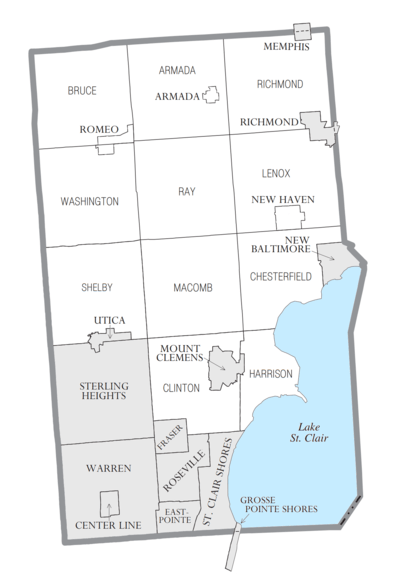
Cities
- Center Line
- Eastpointe (formerly East Detroit)
- Fraser
- Grosse Pointe Shores (partial)
- Memphis (partial)
- Mount Clemens (county seat)
- New Baltimore
- Richmond (partial)
- Roseville
- St. Clair Shores
- Sterling Heights
- Utica
- Warren
Charter townships
Civil townships
Unincorporated communities
- Anchor Bay Gardens
- Anchor Bay Harbor
- Anchor Bay Shores
- Broad Acres
- Cady
- Chesterfield
- Chesterfield Shores
- Clifton Mill
- Davis
- Lakeside
- Lottivue
- Macomb
- Meade
- Milton
- Mount Vernon
- Point Lakeview
- Preston Corners
- Ray Center
- Saint Clair Haven
- Sebille Manor
- Shelby
- Waldenburg
- Washington
- Wolcott Mills
- Yates
Notable people
Actors and actresses
- Dean Cain, actor, Mount Clemens
- Dave Coulier, actor/comedian, St. Clair Shores
- Adrienne Frantz, actress and singer, Mount Clemens, Michigan
- Faye Grant, actress, St. Clair Shores
- Kathleen Rose Perkins, actress, New Baltimore
- Crystal Reed, actress, Roseville, Michigan
Athletes
- George Herbert Allen,coached in the NFL and USFL, St. Clair Shores
- David Booth, NHL player, Washington Township
- Dave Debol, NHL player, St. Clair Shores
- Danny DeKeyser, NHL Player, Macomb County
- John DiGiorgio, NFL Player, Macomb, Shelby Township
- Denny Felsner, NHL player, Warren
- Derian Hatcher, NHL player, Sterling Heights
- Kevin Hatcher, NHL player, Sterling Heights
- Pat Hentgen, MLB player, Fraser
- Bryan Herta, race car driver, Warren
- Matt Hunwick, NHL player, Warren
- Ron Kramer, NFL player, Eastpointe
- Craig Krenzel, NFL player, Sterling Heights
- Chad LaRose, NHL player, Fraser
- John Mazza, PBA bowler, Shelby Township
- Shirley Muldowney, race car driver, Armada
- John Smoltz, MLB player, Warren
- Jim Sorgi, NFL player, Fraser
- Matt Taormina, NHL player, Warren
- Michele Van Gorp, WNBA player from Duke University, Warren
- Doug Weight, NHL player, Warren
- Mark Wells, member of the 1980 Olympic hockey team, St. Clair Shores
- Johnny White, race car driver, Warren
- Ernie Whitt, MLB player, Roseville
- Frank Zombo, NFL player, Sterling Heights
- Kyle Cook, NFL player, Macomb Twp.
- Steve Oleksy, NHL player, Chesterfield Twp.
- Tyler Conklin, NFL player, Chesterfield Twp.
- Sean Murphy-Bunting, NFL Player, Macomb Twp.
Musicians
- Kid Rock, Romeo
- Mitch Ryder, Roseville
- Justin Jeffre, (98 Degrees), Mount Clemens
- Uncle Kracker, Harrison Township
- Eminem, Warren
- Fred 'Sonic' Smith, St. Clair Shores
- Alice Cooper, Eastpointe
- Tarey Wolf, Eastpointe
Other
- Joe Cada, professional poker player, Shelby Township
- Dick Enberg, sportscaster, Armada
- Martha Griffiths, Lieutenant Governor of Michigan (1983–1991), Armada
- Alex Groesbeck, politician, Warren
- Butch Hartman, creator of the cartoon show The Fairly OddParents, New Baltimore
- Ian Hornak, Artist, Mount Clemens
- George F. Lewis, proprietor of newspapers
- Jerry M. Linenger, NASA astronaut, Eastpointe
- Howard Wiest, Chief Justice of the Michigan Supreme Court, Washington Township
See also
- List of Michigan State Historic Sites in Macomb County, Michigan
- National Register of Historic Places listings in Macomb County, Michigan
References
- "Bibliography on Macomb County". Clarke Historical Library, Central Michigan University. Retrieved January 20, 2013.
- "Macomb County Home Page". macombgov.org. Archived from the original on October 2, 2006.
- "State & County QuickFacts". United States Census Bureau. Archived from the original on July 14, 2011. Retrieved August 28, 2013.
- "Find a County". National Association of Counties. Retrieved June 7, 2011.
- "Macomb County Michigan : HISTORY OF MACOMB COUNTY". macombcountymi.gov. Archived from the original on March 15, 2012.
- "Macomb Co. - Election Results - Macomb County". newsroomsolutions.com.
- "Macomb County Election Results". Detroit Free Press. November 3, 2010. Retrieved November 9, 2010.
- "2010 Census Gazetteer Files". United States Census Bureau. August 22, 2012. Archived from the original on November 13, 2013. Retrieved September 27, 2014.
- "Population and Housing Unit Estimates". Retrieved March 26, 2020.
- "U.S. Decennial Census". United States Census Bureau. Retrieved September 27, 2014.
- "Historical Census Browser". University of Virginia Library. Retrieved September 27, 2014.
- "Population of Counties by Decennial Census: 1900 to 1990". United States Census Bureau. Retrieved September 27, 2014.
- "Census 2000 PHC-T-4. Ranking Tables for Counties: 1990 and 2000" (PDF). United States Census Bureau. Retrieved September 27, 2014.
- Data Access and Dissemination Systems (DADS). "U.S. Census website". census.gov.
- "U.S. Census website". Retrieved June 20, 2007.
- Selweski, Chad. "Albanians, Chaldeans, Arabs and Asians move to Macomb County" (Archive). The Macomb Daily. March 23, 2011. Retrieved on July 6, 2015.
- "U.S. Census website". United States Census Bureau. Retrieved December 6, 2017.
- https://www.michigan.org/property/macomb-county-chamber
- "2016 Presidential General Election Results". Atlas of U.S. Presidential Elections. Retrieved August 3, 2017.
- "More election games by county GOP". Downtown. December 4, 2014. Archived from the original on September 14, 2016. Retrieved June 26, 2016.
- Lord, Jeffrey (August 13, 2015). "Are Reagan Democrats Becoming Trump Democrats?". The American Spectator.
- Witcover, Jules (March 14, 1992). "Buchanan, Bush stump in Michigan President again spurns debate plea". The Baltimore Sun.
- Witsil, Frank (November 9, 2016). "RTA millage rejected by metro Detroit voters". Detroit Free Press. Retrieved November 29, 2016.
External links
- Macomb County - Official Website
- Macomb County Library
- "Bibliography on Macomb County". Clarke Historical Library, Central Michigan University. Retrieved January 20, 2013.
- View Fiscal Transparency Data for Macomb County
Places adjacent to Macomb County, Michigan | ||||||||||
|---|---|---|---|---|---|---|---|---|---|---|
| ||||||||||
Municipalities and communities of Macomb County, Michigan, United States | ||
|---|---|---|
| Cities | Map of Michigan highlighting Macomb County.svg | |
| Villages | ||
| Charter townships | ||
| Civil townships | ||
| Unincorporated communities |
| |
| Footnotes | ‡This populated place also has portions in an adjacent county or counties | |
| Topics | 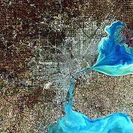 | |
|---|---|---|
| Detroit | ||
| Municipalities over 80,000 | ||
| Municipalities 40,000 to 80,000 | ||
| Cultural enclaves | ||
| Satellite cities | ||
| Counties in MSA | ||
| Counties in CSA | ||

| Authority control |
|
|---|