Newaygo County, Michigan
Newaygo County is a county in the U.S. state of Michigan. As of the 2010 United States Census, the population was 48,460.[2] The county seat is White Cloud.[3] The county was created in 1840, and was organized in 1851. It was either named for an Ojibwe leader who signed the Treaty of Saginaw in 1819[1] or for an Algonquian word meaning "much water".[4]
Newaygo County | |
|---|---|
.jpg) Newaygo County Courthouse | |
 Seal | |
 Location within the U.S. state of Michigan | |
 Michigan's location within the U.S. | |
| Coordinates: 43°33′N 85°48′W | |
| Country | |
| State | |
| Founded | 1840 (established) 1851 (organized)[1] |
| Seat | White Cloud |
| Largest city | Fremont |
| Area | |
| • Total | 862 sq mi (2,230 km2) |
| • Land | 813 sq mi (2,110 km2) |
| • Water | 48 sq mi (120 km2) 5.6%% |
| Population | |
| • Estimate (2018) | 48,892 |
| • Density | 60/sq mi (22/km2) |
| Time zone | UTC−5 (Eastern) |
| • Summer (DST) | UTC−4 (EDT) |
| Congressional district | 2nd |
Geography
According to the US Census Bureau, the county has an area of 862 square miles (2,230 km2), of which 813 square miles (2,110 km2) is land and 48 square miles (120 km2) (5.6%) is covered by water.[5] The county is considered to be part of West Michigan.
The county has more than 230 natural lakes. The combined total length of all the county's rivers and streams exceeds 350 miles (560 km). Three huge dams, Croton, Hardy, and Newaygo, were built at the beginning of the 20th century. The Hardy Dam is the largest earthen dam east of the Mississippi.[6] Over half of the county is in the Manistee National Forest.
Major highways


Adjacent counties
- Mason County – northwest
- Lake County – north
- Osceola County - northeast
- Mecosta County – east
- Montcalm County – southeast
- Kent County – south
- Muskegon County – southwest
- Oceana County – west
National protected area
- Manistee National Forest (part)
Demographics
| Historical population | |||
|---|---|---|---|
| Census | Pop. | %± | |
| 1850 | 510 | — | |
| 1860 | 2,760 | 441.2% | |
| 1870 | 7,294 | 164.3% | |
| 1880 | 14,688 | 101.4% | |
| 1890 | 20,476 | 39.4% | |
| 1900 | 17,673 | −13.7% | |
| 1910 | 19,220 | 8.8% | |
| 1920 | 17,378 | −9.6% | |
| 1930 | 17,029 | −2.0% | |
| 1940 | 19,286 | 13.3% | |
| 1950 | 21,567 | 11.8% | |
| 1960 | 24,160 | 12.0% | |
| 1970 | 27,992 | 15.9% | |
| 1980 | 34,917 | 24.7% | |
| 1990 | 38,202 | 9.4% | |
| 2000 | 47,874 | 25.3% | |
| 2010 | 48,460 | 1.2% | |
| Est. 2018 | 48,892 | [8] | 0.9% |
| US Decennial Census[9] 1790-1960[10] 1900-1990[11] 1990-2000[12] 2010-2018[2] | |||
As of the 2000 United States Census,[13] there were 47,874 people, 17,599 households, and 12,935 families in the county. The population density was 57 people per square mile (22/km²). There were 23,202 housing units at an average density of 28 per square mile (11/km²). The racial makeup of the county was 94.80% White, 1.12% Black or African American, 0.65% Native American, 0.29% Asian, 0.03% Pacific Islander, 1.63% from other races, and 1.48% from two or more races. 3.85% of the population were Hispanic or Latino of any race. 21.5% were of English ancestry, 20.5% were of German ancestry, 14.4% were of Dutch ancestry, 8.1% were of Irish ancestry and 5.0% were of Polish ancestry according to the 2010 American Community Survey.[14] 95.7% spoke English and 3.2% Spanish as their first language.
There were 17,599 households out of which 35.20% had children under the age of 18 living with them, 60.20% were married couples living together, 9.00% had a female householder with no husband present, and 26.50% were non-families. 22.20% of all households were made up of individuals and 9.00% had someone living alone who was 65 years of age or older. The average household size was 2.68 and the average family size was 3.13.
The county population contained 29.10% under the age of 18, 7.40% from 18 to 24, 27.50% from 25 to 44, 23.20% from 45 to 64, and 12.80% who were 65 years of age or older. The median age was 36 years. For every 100 females, there were 99.60 males. For every 100 females age 18 and over, there were 97.20 males.
The median income for a household in the county was $37,130, and the median income for a family was $42,498. Males had a median income of $35,549 versus $22,738 for females. The per capita income for the county was $16,976. About 9.00% of families and 11.60% of the population were below the poverty line, including 14.60% of those under age 18 and 8.50% of those age 65 or over.
Religion
- The Catholic church – 3,242 members
- The Christian Reformed Church in North America – 7 congregations and 2,056 members
- The United Methodist Church – 7 congregations and 1,600 members
- The Reformed Church in America – 3 congregations and 1,000 members[15]
- The Church of Jesus Christ of Latter-day Saints - 1 meetinghouse in the county.[16]
Newaygo County is part of the Roman Catholic Diocese of Grand Rapids.[17]
Economy
Tourism is the most important economic activity in Newaygo County.[18] Secondly is a blend of agricultural and small manufacturing. International baby food manufacturer Gerber Products Company is currently the county's largest employer with approximately 1,300 employees.[19]
Newaygo County also has a large number of summer cottage residents. Fishermen can find many steelhead in the spring and salmon in the fall within the county's rivers and streams. Camping, hunting, cross country skiing, bicycling, birding and ORVing is common in the Manistee National Forest.[6]
Notable companies
- County of Newaygo - White Cloud
- Dura Automotive Systems - Fremont
- Gerber Memorial Health Services - Fremont
- Gerber Products Company - Fremont
- Magna Donnelly - Newaygo
- North American Refractories - White Cloud
- Valspar Corporation - Fremont
- Wilbur Ellis - Grant
- Newaygo Brewing - Newaygo
Government
Newaygo County has been strongly Republican since the Civil War era. Since 1884, the Republican Party nominee has carried the county vote in 91% of the national presidential elections (31 of 34).
| Year | Republican | Democratic | Third Parties |
|---|---|---|---|
| 2016 | 66.6% 15,173 | 27.3% 6,212 | 6.1% 1,397 |
| 2012 | 58.0% 12,457 | 40.6% 8,728 | 1.4% 293 |
| 2008 | 51.1% 11,862 | 46.5% 10,790 | 2.4% 544 |
| 2004 | 59.5% 13,608 | 39.6% 9,057 | 0.9% 208 |
| 2000 | 58.3% 11,399 | 39.3% 7,677 | 2.5% 481 |
| 1996 | 44.6% 7,868 | 43.1% 7,614 | 12.3% 2,169 |
| 1992 | 40.9% 7,333 | 36.0% 6,455 | 23.0% 4,128 |
| 1988 | 64.3% 9,896 | 35.0% 5,389 | 0.7% 100 |
| 1984 | 70.0% 10,636 | 29.6% 4,496 | 0.5% 73 |
| 1980 | 58.6% 8,918 | 34.4% 5,236 | 7.0% 1,069 |
| 1976 | 58.8% 8,258 | 40.0% 5,622 | 1.2% 170 |
| 1972 | 65.6% 8,245 | 31.7% 3,978 | 2.7% 342 |
| 1968 | 60.0% 6,626 | 30.5% 3,369 | 9.5% 1,053 |
| 1964 | 47.4% 4,931 | 52.5% 5,457 | 0.1% 11 |
| 1960 | 68.6% 7,453 | 31.3% 3,404 | 0.1% 15 |
| 1956 | 71.5% 7,088 | 28.3% 2,808 | 0.2% 20 |
| 1952 | 71.8% 6,715 | 27.2% 2,541 | 1.0% 95 |
| 1948 | 66.9% 4,394 | 30.9% 2,027 | 2.2% 145 |
| 1944 | 70.6% 5,250 | 29.0% 2,156 | 0.4% 28 |
| 1940 | 66.5% 5,418 | 33.1% 2,693 | 0.4% 34 |
| 1936 | 51.4% 3,930 | 43.0% 3,288 | 5.6% 426 |
| 1932 | 49.7% 3,458 | 47.1% 3,275 | 3.2% 220 |
| 1928 | 83.3% 4,552 | 16.3% 888 | 0.5% 25 |
| 1924 | 79.2% 4,243 | 13.4% 720 | 7.3% 393 |
| 1920 | 78.9% 4,188 | 17.5% 929 | 3.6% 190 |
| 1916 | 58.3% 2,417 | 39.2% 1,625 | 2.6% 106 |
| 1912 | 24.6% 964 | 19.8% 776 | 55.6% 2,180 |
| 1908 | 69.4% 2,677 | 24.8% 956 | 5.9% 226 |
| 1904 | 75.9% 2,966 | 20.2% 790 | 3.9% 154 |
| 1900 | 62.7% 2,607 | 34.2% 1,424 | 3.1% 128 |
| 1896 | 56.5% 2,650 | 41.5% 1,943 | 2.0% 95 |
| 1892 | 51.0% 2,106 | 37.1% 1,531 | 11.9% 491 |
| 1888 | 51.9% 2,448 | 40.9% 1,932 | 7.2% 341 |
| 1884 | 46.7% 1,971 | 48.5% 2,051 | 4.8% 203 |
Newaygo County operates the County jail, maintains rural roads, operates the major local courts, records deeds, mortgages, and vital records, administers public health regulations, and participates with the state in the provision of social services. The county board of commissioners controls the budget and has limited authority to make laws or ordinances. In Michigan, most local government functions – police and fire, building and zoning, tax assessment, street maintenance etc. – are the responsibility of individual cities and townships.
Elected officials
- Prosecuting Attorney: Worth Stay
- Sheriff:Robert (Bob) Mendham
- County Clerk: Jason VanderStelt
- County Treasurer: Holly Moon
- Register of Deeds:Stewart K. Sanders
- Drain Commissioner: Dale Twing[21]
(information as of September 2018)
Festivals and events
- Memorial Weekend Arts & Crafts Festival - Newaygo
- River Country Home & Garden Show - Newaygo Middle School
- Newaygo County Kids' Day - Downtown Newaygo
- Trail Town Celebration - Celebrating White Clouds Trails & Waterways
- City-Wide Yard Sales - Grant
- Harvest Celebration - Grant
- Harvest Festival - Fremont
- Logging Festival - Mid-Michigan Lumberjack Competition in Newaygo
- Bitely Homecoming - Bitely
- National Baby Food Festival - Fremont
- Pow Wow - White Cloud
- Santa Parade - Fremont
- West Michigan's Longest Yard Sale - Grant, Newaygo, White Cloud, Bitely
- Winterfest - Newaygo
- Christmas in Newaygo
- Christmas in Grant
- Christmas in White Cloud
Historic sites
In Newaygo County there are 16 locations that the State Historic Preservation Office has designated as historical. Two of the sixteen have been listed with the National Register of Historic Places:[22]
- Big Prairie Grange Hall No. 935 - Goodwell Twp
- Birch Grove School - Lincoln Twp
- Croton Congregational Church - Croton Twp
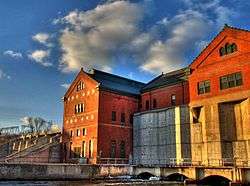
- Croton Hydroelectric Plant - Croton Twp
- Ensley Windmill Tower
- First Christian Reformed Church (Demolished) - Fremont
- Gerber, Cornelius, Cottage - Sheridan Charter Twp
- Grant Depot and Water Tower - Grant
- Hardy Hydroelectric Plant - Big Prairie - Twp
- Lilley District No. 5 School - Lilley Twp
- Oak Grove District No. 3 Schoolhouse - Croton Twp
- Penoyer's Sawmill - Newaygo
- Saint Mark's Episcopal Church - Newaygo
- Weaver, Daniel, House - Denver Twp
- White Cloud Village Hall (Demolished) - White Cloud
- Woods, John F., Residence - Newaygo
Communities
Cities
- Fremont
- Grant
- Newaygo
- White Cloud (county seat)
Villages
- Hesperia (partially)
Unincorporated communities
- Bitely
- Brunswick
- Riverview
- Woodland Park
Townships
- Ashland Township
- Barton Township
- Beaver Township
- Big Prairie Township
- Bridgeton Township
- Brooks Township
- Croton Township
- Dayton Township
- Denver Township
- Ensley Township
- Everett Township
- Garfield Township
- Goodwell Township
- Grant Township
- Home Township
- Lilley Township
- Lincoln Township
- Merrill Township
- Monroe Township
- Norwich Township
- Sheridan Charter Township
- Sherman Township
- Troy Township
- Wilcox Township
See also
- Michigan State Historic Sites in Newaygo County
- National Register of Historic Places listings in Newaygo County MI
References
- "Bibliography on Newaygo County". Clarke Historical Library, Central Michigan University. Retrieved January 20, 2013.
- "State & County QuickFacts". US Census Bureau. Archived from the original on July 5, 2011. Retrieved August 29, 2013.
- "Find a County". National Association of Counties. Retrieved June 7, 2011.
- Michigan government on county names
- "2010 Census Gazetteer Files". US Census Bureau. August 22, 2012. Archived from the original on November 13, 2013. Retrieved September 27, 2014.
- Newaygo County government
- Newaygo County MI Google Maps (accessed 15 September 2018)
- "Population and Housing Unit Estimates". Retrieved May 16, 2019.
- "US Decennial Census". US Census Bureau. Retrieved September 27, 2014.
- "Historical Census Browser". University of Virginia Library. Retrieved September 27, 2014.
- "Population of Counties by Decennial Census: 1900 to 1990". US Census Bureau. Retrieved September 27, 2014.
- "Census 2000 PHC-T-4. Ranking Tables for Counties: 1990 and 2000" (PDF). US Census Bureau. Retrieved September 27, 2014.
- "U.S. Census website". US Census Bureau. Retrieved January 31, 2008.
- "2010 Data Release – Data & Documentation – American Community Survey – US Census Bureau". Archived from the original on October 27, 2015. Retrieved December 28, 2018.
- "The Association of Religion Data Archives - Maps & Reports". thearda.com.
- LDS.org Find a Meetinghouse (accessed 15 September 2018)
- "Diocese of Grand Rapids MI". Archived from the original on March 3, 2008. Retrieved December 28, 2018.
- Peavey, Sandra Vincent; Center, Terry Wantz Historical Research (June 2, 2014). Newaygo County: 1920-2000. Arcadia Publishing. ISBN 9781439645505.
- Michigan Works! West Central
- US Election Atlas
- Newaygo County website
- "State Historical Site Listings". Archived from the original on April 27, 2009. Retrieved December 6, 2008.
External links
| Wikimedia Commons has media related to Newaygo County, Michigan. |
| Wikisource has the text of the 1879 American Cyclopædia article Newaygo. |
"Bibliography on Newaygo County". Clarke Historical Library, Central Michigan University.
- County of Newaygo
- Newaygo County Convention and Visitors Bureau
- Newaygo County Road Commission
- Newaygo County Regional Educational Service Agency
- District Health Department #10
- Recycling for Newaygo County
Places adjacent to Newaygo County, Michigan | ||||||||||
|---|---|---|---|---|---|---|---|---|---|---|
| ||||||||||
Municipalities and communities of Newaygo County, Michigan, United States | ||
|---|---|---|
| Cities | Map of Michigan highlighting Newaygo County | |
| Village | ||
| Charter township | ||
| General law townships | ||
| Unincorporated communities | ||
| Footnotes | ‡This populated place also has portions in an adjacent county or counties | |
| Central cities | |||
|---|---|---|---|
| Counties |
| ||
| Geography | |||
| Transportation | |||
| Economy | |||
| |||

| Authority control |
|
|---|