Hillsdale County, Michigan
Hillsdale County is a county located in the U.S. state of Michigan. As of the 2010 census, the population was 46,688.[2] The county seat is Hillsdale.[3]
Hillsdale County | |
|---|---|
 | |
 Location within the U.S. state of Michigan | |
 Michigan's location within the U.S. | |
| Coordinates: 41°53′N 84°35′W | |
| Country | |
| State | |
| Founded | 1835[1] |
| Seat | Hillsdale |
| Largest city | Hillsdale |
| Area | |
| • Total | 607 sq mi (1,570 km2) |
| • Land | 598 sq mi (1,550 km2) |
| • Water | 8.9 sq mi (23 km2) 1.5%% |
| Population | |
| • Estimate (2018) | 45,749 |
| • Density | 78/sq mi (30/km2) |
| Time zone | UTC−5 (Eastern) |
| • Summer (DST) | UTC−4 (EDT) |
| Congressional district | 7th |
Hillsdale County is the southernmost county in Michigan as there is a bit of land that stretches south more than Lenawee and Monroe counties.
Hillsdale County comprises the Hillsdale, MI Micropolitan Statistical Area.
The Hillsdale County Courthouse was designed by Claire Allen, a prominent southern Michigan architect.
History
The county is named for its rolling terrain.[4] It was described by action of the Michigan Territorial legislature in 1829, and was organized six years later.[1] See List of Michigan county name etymologies.
Hillsdale County was a New England settlement; its early settlers came from the northern coastal colonies – "Yankees", descended from the English Puritans who emigrated from the Old World in the 1600s. There was a wave of such settlers into the Northwest Territory during the early 1800s, many traveling on the newly-completed Erie Canal, and made safe by the conclusion of the Black Hawk War. They brought with them a passion for education, establishing many schools. Many were abolitionists.[5]
Geography
According to the US Census Bureau, the county has a total area of 607 square miles (1,570 km2), of which 598 square miles (1,550 km2) is land and 8.9 square miles (23 km2) (1.5%) is water.<ref">"2010 Census Gazetteer Files". US Census Bureau. August 22, 2012. Archived from the original on November 13, 2013. Retrieved September 25, 2014.</ref> Hillsdale is the only county in Michigan to have a land border with two other states – Ohio and Indiana. The headwaters of two St. Joseph Rivers rise in Hillsdale County: the St. Joseph River (Lake Michigan) and the St. Joseph River (Maumee River).
Parks
- McCourtie Park
- Slayton Arboretum
Adjacent counties
- Jackson County (northeast)
- Calhoun County (northwest)
- Lenawee County (east)
- Branch County (west)
- Fulton County, Ohio (southeast)
- Williams County, Ohio (south)
- Steuben County, Indiana (southwest)
Climate
Hillsdale County experiences four distinct seasons. July is the hottest month with an average high of 82 °F or 27.8 °C and January the coldest with an average high of 29 °F or −1.7 °C. June is the wettest month with 4.29 inches or 109.0 millimetres of rain on average.
| Climate data for Hillsdale, Michigan | |||||||||||||
|---|---|---|---|---|---|---|---|---|---|---|---|---|---|
| Month | Jan | Feb | Mar | Apr | May | Jun | Jul | Aug | Sep | Oct | Nov | Dec | Year |
| Average high °F (°C) | 29 (−2) |
33 (1) |
43 (6) |
56 (13) |
68 (20) |
78 (26) |
82 (28) |
80 (27) |
72 (22) |
60 (16) |
46 (8) |
34 (1) |
57 (14) |
| Average low °F (°C) | 13 (−11) |
14 (−10) |
24 (−4) |
35 (2) |
45 (7) |
55 (13) |
59 (15) |
57 (14) |
49 (9) |
38 (3) |
29 (−2) |
19 (−7) |
36 (2) |
| Average precipitation inches (mm) | 2.10 (53) |
1.82 (46) |
2.77 (70) |
3.39 (86) |
3.82 (97) |
4.29 (109) |
3.54 (90) |
3.70 (94) |
3.71 (94) |
2.82 (72) |
3.07 (78) |
2.66 (68) |
37.69 (957) |
| Source: weather.com | |||||||||||||
Demographics
| Historical population | |||
|---|---|---|---|
| Census | Pop. | %± | |
| 1840 | 7,240 | — | |
| 1850 | 16,159 | 123.2% | |
| 1860 | 25,675 | 58.9% | |
| 1870 | 31,684 | 23.4% | |
| 1880 | 32,723 | 3.3% | |
| 1890 | 30,660 | −6.3% | |
| 1900 | 29,865 | −2.6% | |
| 1910 | 29,673 | −0.6% | |
| 1920 | 28,161 | −5.1% | |
| 1930 | 27,417 | −2.6% | |
| 1940 | 29,092 | 6.1% | |
| 1950 | 31,916 | 9.7% | |
| 1960 | 34,742 | 8.9% | |
| 1970 | 37,171 | 7.0% | |
| 1980 | 42,071 | 13.2% | |
| 1990 | 43,431 | 3.2% | |
| 2000 | 46,527 | 7.1% | |
| 2010 | 46,688 | 0.3% | |
| Est. 2018 | 45,749 | [6] | −2.0% |
| US Decennial Census[7] 1790-1960[8] 1900-1990[9] 1990-2000[10] 2010-2018[2] | |||
As of the 2000 United States Census,[11] there were 46,527 people, 17,335 households, and 12,550 families residing in the county. The population density was 78 people per square mile (30/km²). There were 20,189 housing units at an average density of 34 per square mile (13/km²). The racial makeup of the county was 97.56% White, 0.43% Black or African American, 0.35% Native American, 0.33% Asian, 0.01% Pacific Islander, 0.34% from other races, and 0.98% from two or more races. 1.20% of the population were Hispanic or Latino of any race. 28.4% were of German, 28.2% English and 9.3% Irish ancestry, 97.0% spoke English, 1.2% Spanish and 1.2% German as their first language.
There were 17,335 households out of which 32.90% had children under the age of 18 living with them, 59.90% were married couples living together, 8.40% had a female householder with no husband present, and 27.60% were non-families. 22.90% of all households were made up of individuals and 9.30% had someone living alone who was 65 years of age or older. The average household size was 2.60 and the average family size was 3.05.
The county's population contained 26.30% under the age of 18, 10.00% from 18 to 24, 26.80% from 25 to 44, 23.50% from 45 to 64, and 13.30% who were 65 years of age or older. The median age was 36 years. For every 100 females there were 99.00 males. For every 100 females age 18 and over, there were 96.20 males.
The median income for a household in the county was $40,396, and the median income for a family was $45,895. Males had a median income of $35,349 versus $23,718 for females. The per capita income for the county was $18,255. About 5.20% of families and 8.20% of the population were below the poverty line, including 8.80% of those under age 18 and 8.60% of those age 65 or over.
Government
Hillsdale County has been reliably Republican since the beginning. Since 1884, the Republican Party nominee has carried 94% of the elections (32 of 34).
| Year | Republican | Democratic | Third Parties |
|---|---|---|---|
| 2016 | 70.7% 14,095 | 24.1% 4,799 | 5.2% 1,046 |
| 2012 | 61.4% 11,727 | 37.2% 7,106 | 1.4% 267 |
| 2008 | 54.9% 11,221 | 42.9% 8,765 | 2.3% 463 |
| 2004 | 63.3% 12,804 | 35.2% 7,123 | 1.4% 289 |
| 2000 | 60.0% 10,483 | 37.2% 6,495 | 2.8% 495 |
| 1996 | 48.6% 7,947 | 36.4% 5,955 | 15.1% 2,464 |
| 1992 | 42.4% 7,579 | 29.3% 5,244 | 28.3% 5,068 |
| 1988 | 68.3% 10,571 | 30.8% 4,763 | 0.9% 145 |
| 1984 | 76.5% 12,063 | 22.9% 3,616 | 0.6% 89 |
| 1980 | 66.4% 10,951 | 26.5% 4,375 | 7.1% 1,173 |
| 1976 | 62.2% 9,307 | 36.3% 5,427 | 1.5% 221 |
| 1972 | 68.6% 9,261 | 29.2% 3,942 | 2.1% 289 |
| 1968 | 63.3% 8,506 | 28.3% 3,803 | 8.4% 1,135 |
| 1964 | 49.1% 6,420 | 50.2% 6,564 | 0.8% 106 |
| 1960 | 71.2% 10,208 | 28.4% 4,069 | 0.4% 63 |
| 1956 | 74.7% 10,311 | 24.8% 3,428 | 0.5% 67 |
| 1952 | 75.5% 10,680 | 23.6% 3,340 | 0.9% 123 |
| 1948 | 67.2% 7,232 | 28.8% 3,095 | 4.0% 433 |
| 1944 | 74.3% 9,364 | 25.0% 3,153 | 0.6% 81 |
| 1940 | 72.3% 9,398 | 27.2% 3,538 | 0.6% 71 |
| 1936 | 55.0% 6,723 | 41.1% 5,023 | 3.9% 471 |
| 1932 | 49.5% 5,879 | 48.0% 5,696 | 2.5% 292 |
| 1928 | 81.0% 8,282 | 18.5% 1,893 | 0.5% 51 |
| 1924 | 68.5% 6,556 | 20.7% 1,980 | 10.9% 1,042 |
| 1920 | 71.1% 6,690 | 26.2% 2,467 | 2.7% 249 |
| 1916 | 48.7% 3,463 | 48.1% 3,424 | 3.2% 226 |
| 1912 | 20.7% 1,437 | 32.1% 2,229 | 47.3% 3,283 |
| 1908 | 61.0% 4,463 | 34.4% 2,516 | 4.7% 340 |
| 1904 | 70.5% 4,951 | 23.6% 1,659 | 6.0% 418 |
| 1900 | 56.9% 4,780 | 39.6% 3,324 | 3.5% 293 |
| 1896 | 52.1% 4,564 | 45.5% 3,986 | 2.4% 206 |
| 1892 | 53.7% 4,119 | 34.0% 2,613 | 12.3% 946 |
| 1888 | 57.0% 4,959 | 34.9% 3,035 | 8.1% 706 |
| 1884 | 52.8% 4,315 | 39.4% 3,222 | 7.8% 635 |
The county government operates the jail, maintains rural roads, operates the major local courts, records deeds, mortgages, and vital records, administers public health regulations, and participates with the state in the provision of social services. The county board of commissioners controls the budget and has limited authority to make laws or ordinances. In Michigan, most local government functions — police and fire, building and zoning, tax assessment, street maintenance, etc. — are the responsibility of individual cities and townships.
Elected officials
- Circuit Court Judge: Honorable Michael R. Smith
- District Court Judge: Honorable Sara S. Lisznyai
- Probate Judge: Honorable Michelle A. Bianchi
- Prosecuting Attorney: Neal A. Brady
- Sheriff: Timothy J. Parker
- County Clerk: Marney Kast
- County Treasurer: Gary A. Leininger
- Register of Deeds: Bambi L. Somerlott
- Drain Commissioner: William Word
- Board of Commissioners:
- District One: Ruth Brown
- District Two: Andy Weldon, Vice Chairperson
- District Three: Mark E. Wiley, Chairperson
- District Four: Bruce Caswell
- District Five: John Burtka
Transportation
Major highways


Airports
Hillsdale Municipal Airport (KJYM) established in 1934, has a 5000' paved and lighted runway with instrument approaches, hangars, tie-downs, and fuel services available. It allows general aviation access to Hillsdale County and nearby areas.
Trails
The 4000 mile National Scenic North Country Trail passes through the county in a north-south direction.
Communities
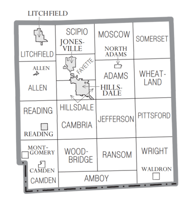
Cities
- Hillsdale (county seat)
- Jonesville
- Litchfield
- Reading
Villages
Civil townships
- Adams Township
- Allen Township
- Amboy Township
- Cambria Township
- Camden Township
- Fayette Township
- Hillsdale Township
- Jefferson Township
- Litchfield Township
- Moscow Township
- Pittsford Township
- Ransom Township
- Reading Township
- Scipio Township
- Somerset Township
- Wheatland Township
- Woodbridge Township
- Wright Township
Unincorporated communities
Notable people
- Moses Allen, first settler and veteran of the War of 1812.
- Oscar F. Avery (1841–1924), lawyer and Illinois state senator, was born in Allen Township.
- Don A. Jones (1912–2000), admiral and civil engineer, seventh Director of the United States Coast and Geodetic Survey and second Director of the Environmental Science Services Administration Corps, born in Waldron.
See also
- Bawbeese
- National Register of Historic Places listings in Hillsdale County, Michigan
- List of Michigan State Historic Sites in Hillsdale County, Michigan
References
- "Bibliography on Hillsdale County". Clarke Historical Library, Central Michigan University. Retrieved January 19, 2013.
- "State & County QuickFacts". US Census Bureau. Archived from the original on June 6, 2011. Retrieved August 27, 2013.
- "Find a County". National Association of Counties. Archived from the original on May 31, 2011. Retrieved July 7, 2011.
- Gannett, Henry (1905). The Origin of Certain Place Names in the United States. Govt. Print. Off. p. 157.
- The Expansion of New England: The Spread of New England Settlement and Institutions to the Mississippi River, 1620-1865. Lois Kimball Mathews Rosenberry, Houghton Mifflin, 1909. pp. 227-8
- "Population and Housing Unit Estimates". Retrieved May 16, 2019.
- "US Decennial Census". US Census Bureau. Retrieved September 25, 2014.
- "Historical Census Browser". University of Virginia Library. Retrieved September 25, 2014.
- "Population of Counties by Decennial Census: 1900 to 1990". US Census Bureau. Retrieved September 25, 2014.
- "Census 2000 PHC-T-4. Ranking Tables for Counties: 1990 and 2000" (PDF). US Census Bureau. Retrieved September 25, 2014.
- "U.S. Census website". US Census Bureau. Retrieved January 31, 2008.
- US Election Atlas
Further reading
- Romig, Walter (1986) [1973]. Michigan Place Names: The History of the Founding and the Naming of More than Five Thousand Past and Present Michigan Communities. Great Lakes Books. Detroit: Wayne State University Press. ISBN 978-0814318386.
External links
| Wikimedia Commons has media related to Hillsdale County, Michigan. |
- Hillsdale County government
- "Bibliography on Hillsdale County". Clarke Historical Library, Central Michigan University.
Places adjacent to Hillsdale County, Michigan | ||||||||||
|---|---|---|---|---|---|---|---|---|---|---|
| ||||||||||
Municipalities and communities of Hillsdale County, Michigan, United States | ||
|---|---|---|
| Cities | Map of Michigan highlighting Hillsdale County.svg | |
| Villages | ||
| Civil townships | ||
| Unincorporated communities | ||

| Authority control |
|
|---|