Taylor, Michigan
Taylor is a city in Wayne County in the U.S. state of Michigan. Its population was 63,131 at the 2010 census.[7] Taylor is the fifth most populated city in Wayne County and the 17th most populated city in Michigan.
Taylor, Michigan | |
|---|---|
| City of Taylor | |
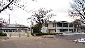 City of Taylor Municipal Offices | |
 Flag  Seal | |
| Nickname(s): | |
| Motto(s): "Made For You" | |
 Location within Wayne County | |
 Taylor Location within the state of Michigan | |
| Coordinates: 42°14′27″N 83°16′11″W | |
| Country | |
| State | |
| County | |
| Organized | 1847 (township) |
| Incorporated | 1968 (city) |
| Government | |
| • Type | Mayor–council |
| • Mayor | Rick Sollars |
| • Clerk | Cynthia Bower |
| Area | |
| • City | 23.63 sq mi (61.21 km2) |
| • Land | 23.61 sq mi (61.14 km2) |
| • Water | 0.03 sq mi (0.07 km2) |
| Elevation | 614 ft (187 m) |
| Population | |
| • City | 63,131 |
| • Estimate (2019)[5] | 60,922 |
| • Density | 2,595.78/sq mi (1,002.23/km2) |
| • Metro | 4,285,832 (Metro Detroit) |
| Time zone | UTC−5 (Eastern (EST)) |
| • Summer (DST) | UTC−4 (EDT) |
| ZIP code(s) | 48180 |
| Area code(s) | 313 and 734 |
| FIPS code | 26-79000 |
| GNIS feature ID | 1614609[6] |
| Website | Official website |
The area was originally a civil township known as Taylor Township, which was organized in 1848 and later incorporated as the city of Taylor in 1968. Taylor is the most-populated municipality of the Downriver community, and it is located about 5 miles (8.0 km) west of the southern border of Detroit and about 15 miles (24.1 km) southwest of Downtown Detroit.
Taylor is home to the Southland Center, Taylor Sportsplex, Beaumont Hospital – Taylor, the Downriver Campus of the Wayne County Community College District, and is the founding location of Hungry Howie's Pizza. The city was also home to the now-demolished Gibraltar Trade Center. Heritage Park is located within the city and hosts the Junior League World Series, which invites youth baseball players from all over the world for an annual tournament in August. The city is served by the Taylor School District.
History
The city of Taylor traces its origins back to Taylor Township, which was organized on March 16, 1847 from 24 square miles (62.2 km2) that were originally part of Ecorse Township to the east. The township was named after Major General Zachary Taylor, who served several posts in the Michigan Territory and later commanded forces during the Mexican–American War (1846–1848). He was soon elected as the 12th president of the United States, serving from March 1849 until his death in July 1850.
Taylor is the location of the first American Bektashi Sufi lodge, which was established in 1954 with significant support from the Albanian-American community of the Detroit area.[8]
Due to the Southern roots of many of its residents, Taylor is nicknamed "Taylortucky."[1][2]
Taylor has been visited by three U.S. presidents: Bill Clinton, George W. Bush and Barack Obama. Current vice president Mike Pence has also visited Taylor.
Mayor Rick Sollars and two others are under Federal indictment as of mid-December 2019 on 33 charges including bribery, wire fraud, and conspiracy.[9]
Geography
According to the United States Census Bureau, the city has a total area of 23.63 square miles (61.20 km2), of which 23.60 square miles (61.12 km2) is land and 0.03 square miles (0.08 km2) (0.13%) is water.[7]
Main highways


Other main roads
- Eureka Road is an important east–west artery in the city, which holds Taylor's shopping district and intersects I-75.
- Van Born Road forms the northern border of Taylor, shared with Dearborn Heights. Just east of Taylor's city limits, the road curves north and becomes Southfield Freeway.
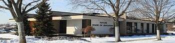
- Goddard Road runs east–west through the center of the city and holds Taylor's municipal buildings near its intersection with Telegraph.
- Northline Road runs east–west a mile south of Goddard and holds Wayne County Community College, as well as the southern entrance to the Heritage Park
- Allen Road and Pelham Road both form Taylor's eastern border. Allen Road travels north–south as Taylor's border with Southgate and then veers north-east into Allen Park, at which point Taylor's border with Allen Park becomes Pelham Road.
- Inkster Road and Pennsylvania Road form Taylor's western and southern borders, respectively.
Neighboring communities
The City of Taylor is bordered by seven other communities.
Places adjacent to Taylor, Michigan | |
|---|---|
Demographics
| Historical population | |||
|---|---|---|---|
| Census | Pop. | %± | |
| 1970 | 70,020 | — | |
| 1980 | 77,568 | 10.8% | |
| 1990 | 70,811 | −8.7% | |
| 2000 | 65,868 | −7.0% | |
| 2010 | 63,131 | −4.2% | |
| Est. 2019 | 60,922 | [5] | −3.5% |
| U.S. Decennial Census 2018 Estimate[10] | |||
2010 census
As of the census[4] of 2010, there were 63,131 people, 24,370 households, and 16,700 families residing in the city. The population density was 2,675.0 inhabitants per square mile (1,032.8/km2). There were 26,422 housing units at an average density of 1,119.6 per square mile (432.3/km2). The racial makeup of the city was 78.0% White, 15.8% African American, 0.5% Native American, 1.8% Asian, 1.3% from other races, and 2.6% from two or more races. Hispanic or Latino of any race were 5.1% of the population.
There were 24,370 households, of which 35.3% had children under the age of 18 living with them, 41.4% were married couples living together, 20.4% had a female householder with no husband present, 6.8% had a male householder with no wife present, and 31.5% were non-families. 25.5% of all households were made up of individuals, and 9.1% had someone living alone who was 65 years of age or older. The average household size was 2.56 and the average family size was 3.05.
The median age in the city was 36.9 years. 24.7% of residents were under the age of 18; 10.1% were between the ages of 18 and 24; 26.5% were from 25 to 44; 26.1% were from 45 to 64; and 12.8% were 65 years of age or older. The gender makeup of the city was 47.9% male and 52.1% female.
2000 census
As of the census of 2000, there were 65,868 people, 24,776 households, and 17,739 families residing in the city. The population density was 2,789.8 per square mile (1,077.2/km2). There were 25,905 housing units at an average density of 1,097.2 per square mile (423.6/km2). The racial makeup of the city was 86.13% White, 8.75% African American, 0.68% Native American, 1.63% Asian, 0.03% Pacific Islander, 0.75% from other races, and 2.04% from two or more races. Hispanic or Latino of any race were 3.24% of the population.
There were 24,776 households, out of which 34.9% had children under the age of 18 living with them, 48.7% were married couples living together, 17.4% had a female householder with no husband present, and 28.4% were non-families. 23.1% of all households were made up of individuals, and 7.6% had someone living alone who was 65 years of age or older. The average household size was 2.63 and the average family size was 3.09.
In the city, the population was spread out, with 27.2% under the age of 18, 9.3% from 18 to 24, 31.0% from 25 to 44, 21.5% from 45 to 64, and 11.0% who were 65 years of age or older. The median age was 34 years. For every 100 females, there were 93.2 males. For every 100 females age 18 and over, there were 89.3 males.
The median income for a household in the city was $42,944, and the median income for a family was $48,304. Males had a median income of $41,170 versus $25,999 for females. The per capita income for the city was $19,638. About 8.9% of families and 10.8% of the population were below the poverty line, including 16.3% of those under age 18 and 6.5% of those age 65 or over.
Economy
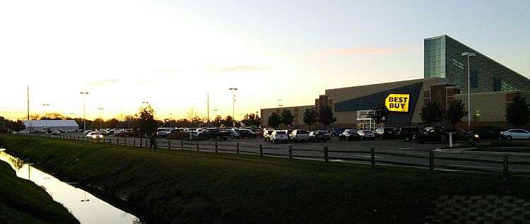
In addition to its schools, the Downriver Campus of the Wayne County Community College District, churches, parks, golf courses, recreation center, library, and the Oakwood Health System’s Heritage Hospital, Taylor also has commercial and industrial sectors, restaurants, and shopping. Southland Shopping Center, a regional shopping mall with over 100 stores, was opened in 1970 at Eureka Road and Pardee Road. Macy's, JCPenney, Best Buy, Forever 21, Shoe Carnival, and Ulta stores serve as anchors. In addition to Southland Center, the city also features a Walmart superstore, Target superstore, Meijer superstore, Kohl's, Burlington Coat Factory, Dick's Sporting Goods, Jo-Ann, Bed, Bath, and Beyond, Kroger, and two Home Depot locations, among many others. In 2014, it was announced that the 80 acre property located at Eureka Road and I-75 which previously held the Gibraltar Trade Center would be redeveloped into what became Trader's Pointe, which opened in June 2018 and features a Menards and will soon include six other retail big box stores, including one of BJ's Wholesale Club's first two locations in Michigan.
Taylor had also been the home to the headquarters of Masco Corporation, the 13th largest publicly traded company in Michigan. The company has been headquartered in Taylor since its foundation in 1929 by Alex Manoogian. However, in 2015 it was announced the company would be moving out of the City. The property is being leased by Ford Motor Company in an announcement released in April 2017.[11]
Education
The city is served by the Taylor School District, within which there is only one high school: Taylor High School (formerly, Harry S. Truman High School) on Beech Daly Road. Other educational facilities include:
- Taylor Preparatory Charter High School - Taylor Prep Official Website
- Taylor Exemplar Academy (National Heritage Academies) - Taylor Exemplar Academy Official Website
- Baptist Park School - Baptist Park School Official Website
- Trillium Academy - Trillium Academy Official Website
- Wayne County Community College District ~ Downriver Campus - WCCCD Official Website
The Roman Catholic Archdiocese of Detroit previously operated St. Cyril Elementary School, St. Pascal Elementary School, and St. Alfred Elementary School in Taylor. The former two merged in 2000 forming Taylor Catholic School, before closing down in 2007. In 2011, the archdiocese announced that St. Alfred would close. In 2013, the archdiocese sold the attached part of the St. Alfred Elementary to PrepNet Schools and formed Taylor Preparatory Charter High school and walled off the hallways connecting to the main church hall of St. Alfred's.
Gallery
 Beaumont Hospital-Taylor, previously known as Oakwood Heritage Hospital
 The Prudential Security Inc. Building is the tallest building in the City.
 The Heritage Park fishing pond and waterwheel seen from standing on public park path.
 Buck Road as seen from Wick Road. Buck Road is Taylor's only unused abandoned road.
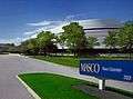 Former headquarters of Masco Corporation, located at 21001 Van Born Road
Notable people
- Steve Avery, retired Major League Baseball player for the Atlanta Braves, Boston Red Sox, Cincinnati Reds and Detroit Tigers
- Joe C., musician and rapper mostly notably associated with Kid Rock
- Wayne Presley, retired National Hockey League player for the Chicago Blackhawks and Buffalo Sabres
References
- Detroit Metro Times Archived January 4, 2014, at the Wayback Machine
- "Downriver: Close to Detroit, Far from Kentucky August 2012; public radio affiliated with Wayne State University, Michigan". wdet.org. Archived from the original on 5 December 2014. Retrieved 5 April 2018.
- "2017 U.S. Gazetteer Files". United States Census Bureau. Retrieved Jan 3, 2019.
- "U.S. Census website". United States Census Bureau. Retrieved 2012-11-25.
- "Population and Housing Unit Estimates". Retrieved May 21, 2020.
- "Taylor". Geographic Names Information System. United States Geological Survey.
- "Michigan: 2010 Population and Housing Unit Counts 2010 Census of Population and Housing" (PDF). 2010 United States Census. United States Census Bureau. September 2012. p. 45 Michigan. Retrieved May 1, 2020.
- Bayraktarı, Cemal (March 1985). "The First American Bektaşi Tekke". Turkish Studies Association Bulletin. 9: 21–24.
- Jim Kasuba (December 19, 2019). "Taylor Mayor Rick Sollars, two others indicted for bribery and fraud". The News-Herald. Retrieved December 19, 2019.
- "Population Estimates". United States Census Bureau. Retrieved June 8, 2018.
- Twitter, Dave Herndon dherndon@heritage.com @NHDaveH on. "Ford Motor Co. moving into former Masco building in Taylor". thenewsherald.com. Retrieved 5 April 2018.
External links
Municipalities and communities of Wayne County, Michigan, United States | ||
|---|---|---|
| Cities |
|  Map of Michigan highlighting Wayne County |
| Charter townships | ||
| Civil townships | ||
| Unincorporated communities |
| |
| Ghost towns | ||
| Footnotes | ‡This populated place also has portions in an adjacent county or counties | |
| Topics |  | |
|---|---|---|
| Detroit | ||
| Municipalities over 80,000 | ||
| Municipalities 40,000 to 80,000 | ||
| Cultural enclaves | ||
| Satellite cities | ||
| Counties in MSA | ||
| Counties in CSA | ||

| Authority control |
|
|---|