Leelanau County, Michigan
Leelanau County (/ˈliːlənɔː/ LEE-lə-naw) is a county located in the U.S. state of Michigan. As of the 2010 census, the population was 21,708.[2] The county seat was until recently the unincorporated community of Leland.[3] On August 3, 2004, county voters approved a proposal to move the county seat to Suttons Bay, closer to the county's geographic center. In 2008, the county offices completed their move to a new government center[4] built on 45 acres (180,000 m²) of county-owned land, one mile east of the unincorporated village of Lake Leelanau, where a new county law enforcement center was completed.
Leelanau County | |
|---|---|
| Leelanau County | |
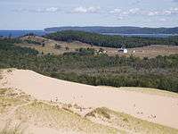  From left to right: Leelanau countryside and Woolsey airport, near the tip of the Leelanau peninsula | |
 Flag  Seal | |
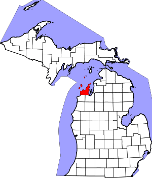 Location within the U.S. state of Michigan | |
 Michigan's location within the U.S. | |
| Coordinates: 45°08′N 86°02′W | |
| Country | |
| State | |
| Founded | 1840 (created) 1863 (organized)[1] |
| Named for | Leelanau Peninsula |
| Seat | Suttons Bay Township |
| Largest settlement | Greilickville Suttons Bay (incorporated) |
| Area | |
| • Total | 2,532 sq mi (6,560 km2) |
| • Land | 347 sq mi (900 km2) |
| • Water | 2,185 sq mi (5,660 km2) 86%% |
| Population | |
| • Estimate (2018) | 21,764 |
| • Density | 63/sq mi (24/km2) |
| Time zone | UTC−5 (Eastern) |
| • Summer (DST) | UTC−4 (EDT) |
| Congressional district | 1st |
Leelanau County is included in the Traverse City Micropolitan Statistical Area of northern Michigan.
In 2011, the Sleeping Bear Dunes National Lakeshore, located in the county, won the title of "Most Beautiful Place in America" in a poll by morning news show Good Morning America.
Etymology
Traditionally, the county's name was said to be a Native American word meaning "delight of life",[1] but it is a neologism from Indian agent and ethnographer Henry Schoolcraft, who sometimes gave the name "Leelinau" to Native American women in his tales. He created many faux Indian place names in Michigan, using syllables of Ojibwe, Latin and Arabic,[5] neglecting the fact that the Ojibwa language lacks any of the phonemes associated with the letter 'L' in English.[6]
More recently, however, scholars have established that Leelinau was first used as a pen name by Henry's wife, Jane Johnston Schoolcraft, in writings for The Literary Voyager, a family magazine which they co-wrote in the 1820s.[7] Jane Johnston was of Ojibwa and Scots-Irish descent, and wrote in Ojibwe and English. While her writing was not published formally in her lifetime (except as Schoolcraft appropriated it under his own name), Jane Johnston Schoolcraft has been recognized as "the first Native American literary writer, the first known Indian woman writer, the first known Indian poet, the first known poet to write poems in a Native American language, and the first known American Indian to write out traditional Indian stories. In 2008 Jane Johnston Schoolcraft was inducted into the Michigan Women's Hall of Fame.[8]
History
The county was set off in 1840, and organized in 1863.[1]
Culture
Wineries
There are 26 wineries on the peninsula.[9] The Leelanau Peninsula sits astride the 45th parallel, a latitude known for growing prestigious grapes. The two Grand Traverse Bays provide the ideal maritime climate and the rich soil does the rest. Northern Michigan specializes in growing white grapes and is known for its rieslings which grow well in the summer months and late fall. The local wineries host an annual harvest fest in October. Some riesling grapes are spared being picked in the fall to be picked when they freeze, from which Ice Wine is made. Wineries in the Leelanau Peninsula AVA include Leelanau Cellars, Silver Leaf Vineyard and Winery, Raftshol Vineyards, Circa Estate Winery, Forty-Five North Vineyard and Winery, Good Harbor Vineyards, Chateau Fontaine, Boskydel Vineyards, Black Star Farms, L. Mawby Vineyards, Ciccone Vineyard and Winery, Willow Vineyards, Chateau de Leelanau Winery and Cidery, Shady Lane Cellars, Cherry Republic Winery, Longview Winery, and Bel Lago Winery.[10]
Geography
According to the U.S. Census Bureau, the county has a total area of 2,532 square miles (6,560 km2), of which 347 square miles (900 km2) is land and 2,185 square miles (5,660 km2) (86%) is water.[11] The county is coextensive with the Leelanau Peninsula.
The county has the second-highest proportion of water area of any county in the United States, behind only Keweenaw County, Michigan. Lake Leelanau is the county's largest body of inland water, formed from the Leland River dam near Leland. Glen Lake, located within the boundaries of Sleeping Bear Dunes National Lakeshore, is considered one of the most beautiful lakes in the world. A substantial portion of Sleeping Bear Dunes National Lakeshore lies within the county's borders, including North Manitou and South Manitou Islands. Leelenau has been party to substantial efforts to protect itself from growth, and to foster a nature conservancy.[12]
Transportation
Major highways


Adjacent counties
- Schoolcraft County - north
- Charlevoix County - northeast
- Antrim County - east
- Grand Traverse County - southeast
- Benzie County - south
- Door County, Wisconsin - west
- Delta County - northwest
Government
Leelanau County has been reliably Republican since its organization. Since 1884, the Republican Party nominee has carried the county vote in 88% (30 of 34) of the national elections through 2016.
| Year | Republican | Democratic | Third Parties |
|---|---|---|---|
| 2016 | 48.6% 7,239 | 45.5% 6,774 | 5.9% 879 |
| 2012 | 52.6% 7,483 | 46.3% 6,576 | 1.1% 160 |
| 2008 | 48.0% 6,938 | 50.9% 7,355 | 1.2% 171 |
| 2004 | 55.6% 7,733 | 43.5% 6,048 | 1.0% 136 |
| 2000 | 57.0% 6,840 | 38.6% 4,635 | 4.5% 534 |
| 1996 | 50.4% 5,155 | 39.3% 4,019 | 10.4% 1,063 |
| 1992 | 39.2% 3,993 | 33.8% 3,445 | 27.0% 2,749 |
| 1988 | 60.5% 5,215 | 38.7% 3,331 | 0.9% 73 |
| 1984 | 67.6% 5,356 | 31.5% 2,498 | 0.9% 67 |
| 1980 | 57.8% 4,585 | 29.6% 2,348 | 12.6% 1,002 |
| 1976 | 62.3% 4,240 | 35.8% 2,437 | 1.9% 126 |
| 1972 | 65.8% 3,809 | 32.1% 1,855 | 2.1% 123 |
| 1968 | 60.1% 2,798 | 33.5% 1,562 | 6.4% 299 |
| 1964 | 46.6% 2,074 | 53.2% 2,369 | 0.2% 8 |
| 1960 | 60.1% 2,730 | 39.8% 1,810 | 0.1% 6 |
| 1956 | 69.8% 2,987 | 30.1% 1,287 | 0.1% 4 |
| 1952 | 74.4% 2,926 | 25.4% 999 | 0.2% 9 |
| 1948 | 69.0% 1,928 | 29.9% 835 | 1.1% 31 |
| 1944 | 68.2% 2,063 | 31.2% 944 | 0.5% 16 |
| 1940 | 66.1% 2,405 | 33.6% 1,223 | 0.3% 11 |
| 1936 | 49.7% 1,692 | 45.3% 1,542 | 5.0% 171 |
| 1932 | 46.1% 1,527 | 52.7% 1,746 | 1.2% 40 |
| 1928 | 62.4% 1,521 | 37.1% 903 | 0.5% 13 |
| 1924 | 75.4% 1,792 | 12.7% 301 | 12.0% 285 |
| 1920 | 82.3% 2,156 | 15.5% 406 | 2.3% 59 |
| 1916 | 53.9% 984 | 41.8% 763 | 4.3% 79 |
| 1912 | 35.4% 621 | 19.6% 344 | 45.0% 788 |
| 1908 | 66.4% 1,258 | 29.9% 566 | 3.8% 72 |
| 1904 | 75.3% 1,464 | 21.4% 416 | 3.3% 65 |
| 1900 | 68.4% 1,468 | 29.5% 634 | 2.1% 44 |
| 1896 | 64.3% 1,402 | 31.6% 690 | 4.1% 90 |
| 1892 | 53.6% 769 | 34.3% 492 | 12.1% 173 |
| 1888 | 55.5% 899 | 41.5% 673 | 3.0% 48 |
| 1884 | 57.8% 811 | 40.7% 571 | 1.5% 21 |
Leelanau County operates the County jail, maintains rural roads, operates the major local courts, records deeds, mortgages, and vital records, administers public health regulations, and participates with the state in the provision of social services. The county board of commissioners controls the budget and has limited authority to make laws or ordinances. In Michigan, most local government functions – police and fire, building and zoning, tax assessment, street maintenance etc. – are the responsibility of individual cities and townships.
Leelenau County recently completed construction of a new jail.
Elected officials
- Prosecuting Attorney – Joseph T. Hubbell
- Probate Judge – Larry Nelson
- Sheriff – Michael Borkovich
- County Clerk – Michelle L. Crocker
- County Treasurer – John A. Gallagher
- Register of Deeds – Dorothy M. Miller
- Drain Commissioner – Steven R. Christensen
- Commissioner Dist. 1 – Tony Ansorge
- Commissioner Dist. 2 – Debra L. Rushton
- Commissioner Dist. 3 – William J. Bunek
- Commissioner Dist. 4 – Ty Wessell
- Commissioner Dist. 5 – Patricia Soutas-Little
- Commissioner Dist. 6 – Casey Noonan
- Commissioner Dist. 7 – Melinda Loutner[15]
(information as of September 2018)
Demographics
| Historical population | |||
|---|---|---|---|
| Census | Pop. | %± | |
| 1860 | 2,158 | — | |
| 1870 | 4,576 | 112.0% | |
| 1880 | 6,253 | 36.6% | |
| 1890 | 7,944 | 27.0% | |
| 1900 | 10,556 | 32.9% | |
| 1910 | 10,608 | 0.5% | |
| 1920 | 9,061 | −14.6% | |
| 1930 | 8,206 | −9.4% | |
| 1940 | 8,436 | 2.8% | |
| 1950 | 8,647 | 2.5% | |
| 1960 | 9,321 | 7.8% | |
| 1970 | 10,872 | 16.6% | |
| 1980 | 14,007 | 28.8% | |
| 1990 | 16,527 | 18.0% | |
| 2000 | 21,119 | 27.8% | |
| 2010 | 21,708 | 2.8% | |
| Est. 2018 | 21,764 | [16] | 0.3% |
| U.S. Decennial Census[17] 2010-2018[2] | |||
As of the 2000 United States Census,[18] there were 21,119 people, 8,436 households, and 6,217 families residing in the county. The population density was 61 people per square mile (23/km²). There were 13,297 housing units at an average density of 38 per square mile (15/km²). The racial makeup of the county was 93.52% White, 0.25% Black or African American, 3.66% Native American, 0.24% Asian, 0.02% Pacific Islander, 1.34% from other races, and 0.97% from two or more races. 3.29% of the population were Hispanic or Latino of any race. 23.3% were of German, 11.5% English, 9.9% Polish, 9.0% Irish, 6.0% French and 5.2% American ancestry. 95.1% spoke English and 2.9% Spanish as their first language.
There were 8,436 households out of which 29.90% had children under the age of 18 living with them, 63.60% were married couples living together, 7.10% had a female householder with no husband present, and 26.30% were non-families. 22.30% of all households were made up of individuals and 8.80% had someone living alone who was 65 years of age or older. The average household size was 2.48 and the average family size was 2.89.
The county population contained 24.40% under the age of 18, 5.70% from 18 to 24, 24.20% from 25 to 44, 28.30% from 45 to 64, and 17.40% who were 65 years of age or older. The median age was 43 years. For every 100 females, there were 99.50 males. For every 100 females age 18 and over, there were 97.10 males.
The median income for a household in the county was $47,062, and the median income for a family was $53,228. Males had a median income of $35,719 versus $25,778 for females. The per capita income for the county was $24,686. About 3.30% of families and 5.40% of the population were below the poverty line, including 6.40% of those under age 18 and 4.50% of those age 65 or over.
Religion
- Leelanau County is part of the Roman Catholic Diocese of Gaylord[19]
- Leelanau County is part of the Episcopal Diocese of Western Michigan.
- There are no meetinghouses of The Church of Jesus Christ of Latter-day Saints in Leelanau County. The nearest is in Traverse City, just over the south county line.[20]
Communities
Cities
- Traverse City (small portion)
Villages
Census-designated places
Unincorporated communities
- Bingham
- Burdickville
- Cherry Bend
- Glen Haven
- Keswick
- Leland
- Northport Point
- Omena
- Peshawbestown
Notable people
- Jim Harrison – author, long-time resident of Leland Township
- Kathleen Sebelius – former Secretary of US Health and Human Services and former governor of Kansas, vacations at a summer home built by her grandfather in Leland.[21][22]
- The northernmost village of Northport and surrounding Leelanau Township have achieved fame as an area where the rich and famous can live quietly and anonymously. According to the Leelanau Visitors Guide: "Chef Mario Batali lives north of town at Cathead point, and comedian and actor Tim Allen routinely spent summers in Northport until his divorce. Financier Mark Spitznagel summers in Northport Point, a posh community just outside the village."[23]
See also
- List of Michigan State Historic Sites in Leelanau County, Michigan
- National Register of Historic Places listings in Leelanau County, Michigan
References
- "Bibliography on Leelanau County". Clarke Historical Library, Central Michigan University. Retrieved January 19, 2013.
- "State & County QuickFacts". US Census Bureau. Retrieved August 28, 2013.
- "Find a County". National Association of Counties. Retrieved June 7, 2011.
- "'Nutcracker' performances set - www.leelanaunews.com - Leelanau Enterprise". leelanaunews.com.
- Michigan Arts and History on Origins of County Names. (28 July 2009)
- Valentine, J. Randolph. "The Sounds of Anishinaabemowin: Consonants and Vowels". Anishinaabemowin. Retrieved January 29, 2020.
- Jeremy Mumford, "Mixed-race identity in a nineteenth-century family: the Schoolcrafts of Sault Ste. Marie, 1824-27", Michigan Historical Review, March 22, 1999, pp. 3-4, accessed December 11, 2008
- Robert Dale Parker, Jane Johnston Schoolcraft, University of Illinois at Urbana-Champaign, accessed December 11, 2008
- Leelanau Wineries|Leelanau Peninsula Wine Trail
- Michigan Wines : Maps : Winery Tour Map : Northwest Region (accessed December 28, 2012)
- "2010 Census Gazetteer Files". US Census Bureau. August 22, 2012. Retrieved September 26, 2014.
- "Home - The Leelanau Conservancy".
- Leelanau County MI Google Maps (accessed September 16, 2018)
- US Election Atlas
- Leelanau County - Directory
- "Population and Housing Unit Estimates". Retrieved May 17, 2019.
- "US Decennial Census". Census.gov. Retrieved June 29, 2013.
- "U.S. Census website". US Census Bureau. Retrieved January 31, 2008.
- "The Diocese of Gaylord, Michigan: A Diocese of the Roman Catholic Church".
- LDS.org Find a Meetinghouse - Leelanau County (accessed September 16, 2018)
- "Camp, Sebelius discuss Leland ties - www.leelanaunews.com - Leelanau Enterprise". leelanaunews.com.
- "Leland offers Sebelius respite from D.C." Traverse City Record-Eagle.
- Leelanau Visitors Guide 2011.
Further reading
- Bogue, Margaret. Around the Shores of Lake Michigan: A Guide to Historic Sites. Madison, WI: University of Wisconsin Press, 1985.
- Reed, Earl H. The Dune Country. Berrien Springs, MI: Hardscrabble Books, 1979. [Reprint of 1916 Edition].
- Ruchhoft, Robert H. Exploring North Manitou, South Manitou, High and Garden Islands of the Lake Michigan Archipelago. Cincinnati, OH: Pucelle Press, 1991.
- Wood, Mable C. Scooterville, U.S.A. Grand Rapids, MI: Eerdmans, 1962.
External links
- [Official website|http://www.leelanau.cc Leelanau County - website]
- Leelanau Peninsula Chamber of Commerce
- Glen Arbor Chamber of Commerce
- Leland Chamber of Commerce
- Northport-Omena Chamber of Commerce
- Suttons Bay Chamber of Commerce
- The Leelanau Enterprise (local newspaper)
- Leelanau.com (news, photos & links)
- The Leelanau Post
- Fountain Point Resort website
Places adjacent to Leelanau County, Michigan | ||||||||||
|---|---|---|---|---|---|---|---|---|---|---|
| ||||||||||
Municipalities and communities of Leelanau County, Michigan, United States | ||
|---|---|---|
| City | Map of Michigan highlighting Leelanau County.svg | |
| Villages | ||
| Charter township | ||
| General law townships | ||
| CDPs | ||
| Other unincorporated communities | ||
| Indian reservation | ||
| Footnotes | ‡This populated place also has portions in an adjacent county or counties | |
| Central cities | |
|---|---|
| Counties | |
| Geography | |
| Transportation | |
| Economy | |
| |

| Authority control |
|
|---|