Westland, Michigan
Westland is a city in Wayne County in the U.S. state of Michigan. It is located about 16 miles (26 km) west of downtown Detroit. As of the 2010 census, the city had a total population of 84,094.[6] It is the 10th largest city and 12th largest municipality in Michigan.
Westland, Michigan | |
|---|---|
| City of Westland | |
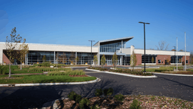 Westland City Hall | |
 Flag  Seal | |
| Nickname(s): An all American City | |
 Location within Wayne County | |
 Westland Location within the state of Michigan | |
| Coordinates: 42°19′27″N 83°24′01″W | |
| Country | |
| State | |
| County | |
| Government | |
| • Mayor | William R. Wild |
| Area | |
| • City | 20.45 sq mi (52.96 km2) |
| • Land | 20.43 sq mi (52.92 km2) |
| • Water | 0.01 sq mi (0.04 km2) |
| Elevation | 666 ft (199 m) |
| Population | |
| • City | 84,094 |
| • Estimate (2019)[3] | 81,511 |
| • Density | 4,000.93/sq mi (1,544.79/km2) |
| • Metro | 4,285,832 (Metro Detroit) |
| Time zone | UTC−5 (EST) |
| • Summer (DST) | UTC−4 (EDT) |
| ZIP code(s) | 48185, 48186, 48187 |
| Area code(s) | 734 |
| FIPS code | 26-86000[4] |
| GNIS feature ID | 1616212[5] |
| Website | Official website |
History
Education
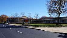
Westland and the city of Wayne form the Wayne-Westland Community School District. There are four high schools, John Glenn, Tinkham Center, and William D. Ford Career Tech Center in Westland, and Wayne Memorial in Wayne. There is a historical site, Perrinsville School in Westland on Warren Road. Nearly all students that live in the city of Wayne go to Wayne Memorial High School, along with some residents of Van Buren Township, Inkster, Romulus, Canton and southern Westland. Students in central Westland and portions of northern Westland, as well as isolated areas of neighboring Inkster and Canton, attend John Glenn High School. The northernmost portions of Westland are in the Livonia Public Schools district.[7]
Portions of Westland that had been in the Taylor School District prior to the 2013 dissolution of the Inkster School District are assigned to Taylor Parks Elementary School,[8] Hoover Middle School,[9] and Harry S. Truman High School in Taylor.[10]
Portions in Livonia School District are assigned to Hayes (in Westland), Rosedale, Garfield, and Cleveland K-4 elementary schools.[11][12] 5-6 elementary schools include Johnson Upper Elementary School (in Westland) and Cooper Upper Elementary School (in Westland). Livonia SD middle schools serving Westland include Frost and Emerson. Livonia SD high schools serving Westland include Churchill High School and Franklin High School.[11][13]
There is a portion of southeastern Westland that is currently divided between Romulus Community Schools and the Taylor School District that was previously assigned to the Inkster School District.[14][15] Romulus Senior High School is the assigned high school for Romulus students. Students in the Inkster zone previously attended Inkster High School.
There is a charter school in Westland, Universal Learning Academy.
Private schools:
St. Damian Catholic School in Westland closed in 2016.[16]
Geography
According to the United States Census Bureau, the city has a total area of 20.45 square miles (52.97 km2), of which 20.43 square miles (52.91 km2) is land and 0.02 square miles (0.05 km2) is water.[17]
Demographics

| Historical population | |||
|---|---|---|---|
| Census | Pop. | %± | |
| 1930 | 9,806 | — | |
| 1940 | 15,838 | 61.5% | |
| 1950 | 30,407 | 92.0% | |
| 1960 | 60,743 | 99.8% | |
| 1970 | 86,749 | 42.8% | |
| 1980 | 84,603 | −2.5% | |
| 1990 | 84,724 | 0.1% | |
| 2000 | 86,602 | 2.2% | |
| 2010 | 84,094 | −2.9% | |
| Est. 2019 | 81,511 | [3] | −3.1% |
| U.S. Decennial Census[18] | |||
2010 census
As of the census[2] of 2010, there were 84,094 people, 35,886 households, and 21,289 families living in the city. The population density was 4,116.2 inhabitants per square mile (1,589.3/km2). There were 39,201 housing units at an average density of 1,918.8 per square mile (740.9/km2). The racial makeup of the city was 75.8% White, 17.2% African American, 0.5% Native American, 3.0% Asian, 1.1% from other races, and 2.4% from two or more races. Hispanic or Latino of any race were 3.8% of the population.
There were 35,886 households, of which 29.6% had children under the age of 18 living with them, 37.5% were married couples living together, 16.4% had a female householder with no husband present, 5.4% had a male householder with no wife present, and 40.7% were non-families. 34.3% of all households were made up of individuals, and 12.5% had someone living alone who was 65 years of age or older. The average household size was 2.31 and the average family size was 2.98.
The median age in the city was 38.3 years. 22.1% of residents were under the age of 18; 9.5% were between the ages of 18 and 24; 27.7% were from 25 to 44; 26.6% were from 45 to 64; and 14% were 65 years of age or older. The gender makeup of the city was 47.5% male and 52.5% female.
2000 census
As of the census[4] of 2000, there were 86,602 people, 36,533 households, and 22,248 families living in the city. The population density was 4,234.9 per square mile (1,635.1/km2). There were 38,077 housing units at an average density of 1,862.0 per square mile (718.9/km2). The racial makeup of the city was 87.21% White, 6.77% African American, 0.46% Native American, 2.81% Asian, 0.03% Pacific Islander, 0.67% from other races, and 2.04% from two or more races. Hispanic or Latino of any race were 2.47% of the population.
There were 36,533 households, out of which 28.6% had children under the age of 18 living with them, 44.4% were married couples living together, 12.1% had a female householder with no husband present, and 39.1% were non-families. 32.6% of all households were made up of individuals, and 11.3% had someone living alone who was 65 years of age or older. The average household size was 2.34 and the average family size was 3.00.
In the city, the population was spread out, with 23.3% under the age of 18, 9.0% from 18 to 24, 33.9% from 25 to 44, 20.6% from 45 to 64, and 13.2% who were 65 years of age or older. The median age was 35 years. For every 100 females, there were 92.6 males. For every 100 females age 18 and over, there were 89.6 males.
The median income for a household in the city was $46,308, and the median income for a family was $55,323. Males had a median income of $45,111 versus $30,143 for females. The per capita income for the city was $22,615. About 4.7% of families and 6.8% of the population were below the poverty line, including 7.6% of those under age 18 and 6.9% of those age 65 or over.
Notable people
- Daron Cruickshank, MMA Fighter, UFC
- Josh Gracin, country singer
- Ryan Scott Graham, musician
- Danielle Hartsell, pair skater
- Steve Hartsell, pair skater
- Motoko Fujishiro Huthwaite, World War II "Monuments Woman," 1927–2020
- Mike Kelley, artist
- Jeremy Langford, running back, Chicago Bears
- Charlie LeDuff, journalist and author [19]
- Mike Modano, NHL Hall of Fame hockey player
- Wanda Young, singer, The Marvelettes
See also
References
- "2017 U.S. Gazetteer Files". United States Census Bureau. Retrieved Jan 3, 2019.
- "U.S. Census website". United States Census Bureau. Retrieved 2012-11-25.
- "Population and Housing Unit Estimates". Retrieved May 21, 2020.
- "U.S. Census website". United States Census Bureau. Retrieved 2008-01-31.
- "US Board on Geographic Names". United States Geological Survey. 2007-10-25. Retrieved 2008-01-31.
- "Race, Hispanic or Latino, Age, and Housing Occupancy: 2010 Census Redistricting Data (Public Law 94-171) Summary File (QT-PL), Westland city, Michigan". United States Census Bureau. Retrieved September 8, 2011.
- Wayne RESA School District Map
- "Elementary School Boundary Map." Taylor School District. Retrieved on April 20, 2014.
- "Middle School Boundary Map." Taylor School District. Retrieved on April 20, 2014.
- "High School Boundary Map." Taylor School District. Retrieved on April 20, 2014.
- "Official Zoning Map." City of Westland. September 2014. Retrieved on April 21, 2016.
- "K-4 Elementary areas." Livonia School District. Retrieved on April 21, 2016.
- "Upper elementary areas, middle school areas, and high school areas." Livonia School District. Retrieved on April 21, 2016.
- "NEW SCHOOL DISTRICT BOUNDARIES FOR INKSTER RESIDENTS" (Map). Wayne RESA. Retrieved on April 20, 2014.
- "Street Jurisdiction Map" (Archive) City of Westland. Retrieved on April 20, 2014.
- "St. Raphael, St. Genevieve, St. Damian schools close". Detroit Free Press. 2016-06-14. Retrieved 2020-05-01.
- "US Gazetteer files 2010". United States Census Bureau. Archived from the original on 2012-01-25. Retrieved 2012-11-25.
- "Census of Population and Housing". Census.gov. Retrieved June 4, 2015.
- Clemens, Paul. "Breakdown ‘Detroit: An American Autopsy,’ by Charlie LeDuff." The New York Times. February 22, 2013. Retrieved on July 12, 2014.
External links
| Wikimedia Commons has media related to Westland, Michigan. |
Municipalities and communities of Wayne County, Michigan, United States | ||
|---|---|---|
| Cities |
|  Map of Michigan highlighting Wayne County |
| Charter townships | ||
| Civil townships | ||
| Unincorporated communities |
| |
| Ghost towns | ||
| Footnotes | ‡This populated place also has portions in an adjacent county or counties | |
| Topics |  | |
|---|---|---|
| Detroit | ||
| Municipalities over 80,000 | ||
| Municipalities 40,000 to 80,000 | ||
| Cultural enclaves | ||
| Satellite cities | ||
| Counties in MSA | ||
| Counties in CSA | ||
