Missaukee County, Michigan
Missaukee County is a county located in the U.S. state of Michigan. As of the 2010 census, the population was 14,849.[2] The county seat is Lake City.[3]
Missaukee County | |
|---|---|
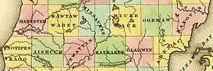 1842 map, showing Missaukee County, then existing only on paper. | |
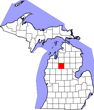 Location within the U.S. state of Michigan | |
 Michigan's location within the U.S. | |
| Coordinates: 44°20′N 85°06′W | |
| Country | |
| State | |
| Founded | 1871[1] |
| Seat | Lake City |
| Largest city | Lake City |
| Area | |
| • Total | 574 sq mi (1,490 km2) |
| • Land | 565 sq mi (1,460 km2) |
| • Water | 9.1 sq mi (24 km2) 1.6%% |
| Population | |
| • Estimate (2018) | 15,113 |
| • Density | 26/sq mi (10/km2) |
| Time zone | UTC−5 (Eastern) |
| • Summer (DST) | UTC−4 (EDT) |
| Congressional district | 4th |
| Website | www |
Missaukee County is part of the Cadillac, MI Micropolitan Statistical Area. The county is considered to be part of Northern Michigan.
Etymology of the name Missaukee
The County may be named after a prominent Ottawa chief, Nesaukee, who signed the treaties of 1831 and 1833.[1][4] However, it is also said that "Nesaukee" could be interpreted as 'large mouth of the river.' [5]
History
Originally the county was part of Mackinac County, Michigan, but was split off on April 1, 1840. Missaukee County was organized in 1871.
Geography
According to the U.S. Census Bureau, the county has a total area of 574 square miles (1,490 km2), of which 565 square miles (1,460 km2) is land and 9.1 square miles (24 km2) (1.6%) is water.[6]
Lakes and rivers
There are 33 natural freshwater lakes in Missaukee County.[7] The largest of these, Lake Missaukee, has a surface area of 1,800 acres (730 ha).[8] The lakes and streams in much of the county drain into the Muskegon River, which flows generally north to south through its eastern tier of townships. The 51.1-mile-long (82.2 km)[9] Clam River, a tributary of the Muskegon, flows generally west to east through the county. The Reedsburg Dam is located within Missaukee County.
Adjacent counties
- Kalkaska County - north
- Crawford County - northeast
- Roscommon County - east
- Clare County - southeast
- Osceola County - southwest
- Wexford County - west
- Grand Traverse County - northwest
Demographics
| Historical population | |||
|---|---|---|---|
| Census | Pop. | %± | |
| 1870 | 130 | — | |
| 1880 | 1,553 | 1,094.6% | |
| 1890 | 5,048 | 225.0% | |
| 1900 | 9,308 | 84.4% | |
| 1910 | 10,606 | 13.9% | |
| 1920 | 9,004 | −15.1% | |
| 1930 | 6,992 | −22.3% | |
| 1940 | 8,034 | 14.9% | |
| 1950 | 7,458 | −7.2% | |
| 1960 | 6,784 | −9.0% | |
| 1970 | 7,126 | 5.0% | |
| 1980 | 10,009 | 40.5% | |
| 1990 | 12,147 | 21.4% | |
| 2000 | 14,478 | 19.2% | |
| 2010 | 14,849 | 2.6% | |
| Est. 2018 | 15,113 | [10] | 1.8% |
| U.S. Decennial Census[11] 1790-1960[12] 1900-1990[13] 1990-2000[14] 2010-2018[2] | |||
As of the census[15] of 2000, there were 14,478 people, 5,450 households, and 4,043 families residing in the county. The population density was 26 people per square mile (10/km²). There were 8,621 housing units at an average density of 15 per square mile (6/km²). The racial makeup of the county was 97.50% White, 0.20% Black or African American, 0.50% Native American, 0.24% Asian, 0.37% from other races, and 1.19% from two or more races. 1.17% of the population were Hispanic or Latino of any race. 24.6% were of Dutch, 18.3% German, 10.8% American, 10.0% English and 7.4% Irish ancestry. 97.9% spoke English and 1.1% Spanish as their first language.
There were 5,450 households out of which 34.00% had children under the age of 18 living with them, 62.80% were married couples living together, 7.40% had a female householder with no husband present, and 25.80% were non-families. 21.50% of all households were made up of individuals and 9.50% had someone living alone who was 65 years of age or older. The average household size was 2.62 and the average family size was 3.03.
In the county, the population was spread out with 27.10% under the age of 18, 7.50% from 18 to 24, 27.20% from 25 to 44, 23.40% from 45 to 64, and 14.80% who were 65 years of age or older. The median age was 38 years. For every 100 females, there were 99.50 males. For every 100 females age 18 and over, there were 98.00 males.
The median income for a household in the county was $35,224, and the median income for a family was $39,057. Males had a median income of $30,565 versus $20,905 for females. The per capita income for the county was $16,072. About 8.20% of families and 10.70% of the population were below the poverty line, including 13.20% of those under age 18 and 10.40% of those age 65 or over.
Religion
The Christian Reformed Church in North America is far the biggest denomination in the county with 2,010 members and 7 congregations, almost 50% of the counties population adhere to the CRCNA,[16] followed by the Reformed Church in America with 3 congregations and 830 members, the third is the United Methodist Church with 3 churches and 500 members, the PC(USA) has 2 congregations and 200 members, but the Evangelical Presbyterian Church, the Lutherans (ELCA), baptists are also represented with 1 congregations each.[17] Missaukee County is part of the Roman Catholic Diocese of Gaylord and has 1 congregations and 800 members.[18] There is an Amish community in the county, founded in 2000, with two church districts in 2013.[19]
Government and politics
| Year | Republican | Democratic | Third Parties |
|---|---|---|---|
| 2016 | 73.6% 5,386 | 21.4% 1,565 | 5.0% 366 |
| 2012 | 66.4% 4,665 | 32.4% 2,274 | 1.3% 88 |
| 2008 | 59.7% 4,469 | 38.7% 2,898 | 1.7% 125 |
| 2004 | 68.1% 5,055 | 31.3% 2,319 | 0.6% 47 |
| 2000 | 65.8% 4,274 | 31.7% 2,062 | 2.5% 160 |
| 1996 | 50.0% 3,012 | 37.4% 2,256 | 12.6% 757 |
| 1992 | 46.7% 2,829 | 31.3% 1,893 | 22.1% 1,336 |
| 1988 | 68.3% 3,566 | 31.0% 1,621 | 0.7% 37 |
| 1984 | 75.5% 3,970 | 23.9% 1,256 | 0.6% 30 |
| 1980 | 63.5% 3,221 | 30.8% 1,563 | 5.7% 291 |
| 1976 | 62.9% 2,943 | 36.1% 1,688 | 1.1% 50 |
| 1972 | 71.8% 2,647 | 25.1% 924 | 3.2% 116 |
| 1968 | 67.7% 2,161 | 23.1% 736 | 9.2% 294 |
| 1964 | 58.1% 1,786 | 41.9% 1,288 | 0.0% 1 |
| 1960 | 79.8% 2,531 | 19.8% 627 | 0.4% 13 |
| 1956 | 76.8% 2,433 | 23.0% 727 | 0.3% 8 |
| 1952 | 80.0% 2,525 | 19.0% 600 | 1.0% 31 |
| 1948 | 68.2% 1,742 | 29.4% 750 | 2.4% 62 |
| 1944 | 71.6% 1,979 | 27.5% 759 | 0.9% 25 |
| 1940 | 66.8% 2,154 | 32.2% 1,037 | 1.0% 32 |
| 1936 | 54.7% 1,730 | 43.8% 1,385 | 1.5% 48 |
| 1932 | 51.6% 1,439 | 46.0% 1,282 | 2.4% 68 |
| 1928 | 87.2% 1,756 | 12.3% 247 | 0.6% 11 |
| 1924 | 85.1% 1,723 | 10.3% 208 | 4.6% 94 |
| 1920 | 82.5% 1,801 | 15.8% 345 | 1.7% 38 |
| 1916 | 54.5% 1,160 | 43.1% 917 | 2.5% 53 |
| 1912 | 32.9% 671 | 17.0% 347 | 50.1% 1,023 |
| 1908 | 75.0% 1,570 | 21.3% 445 | 3.8% 79 |
| 1904 | 80.8% 1,781 | 15.7% 345 | 3.6% 79 |
| 1900 | 67.1% 1,421 | 29.1% 616 | 3.8% 80 |
| 1896 | 55.2% 899 | 42.2% 687 | 2.7% 44 |
| 1892 | 48.6% 665 | 45.5% 622 | 5.9% 81 |
| 1888 | 50.4% 632 | 45.7% 572 | 3.9% 49 |
| 1884 | 54.1% 470 | 42.9% 373 | 3.0% 26 |
The county government operates the jail, maintains rural roads, operates the major local courts, keeps files of deeds and mortgages, maintains vital records, administers public health regulations, and participates with the state in the provision of welfare and other social services. The county board of commissioners controls the budget but has only limited authority to make laws or ordinances. In Michigan, most local government functions — police and fire, building and zoning, tax assessment, street maintenance, etc. — are the responsibility of individual cities and townships.
Elected officials
- Prosecuting Attorney: Melissa Ransom
- Sheriff: James Bosscher
- County Clerk/Register of Deeds: Jessica Nielsen
- County Treasurer: Lori Cox
- Road Commissioners: Jack McGee; Larry Norman; Lonny Lutke
(information as of September 2005)
Election history
Missaukee County is one of Michigan's most strongly Republican counties, and one of the most consistently Republican in the nation since that party was founded. No Democratic presidential candidate has ever won Missaukee County since it was organized:[21] even Lyndon Johnson in 1964 when he swept the Northeast received no more than 41 percent of the county's vote,[22] which made Missaukee Barry Goldwater’s strongest county north or east of the Great Lakes. No Democrat since has received more than Barack Obama's 38 percent in 2008. In 2004, Republican George W. Bush received 68.1% in Missaukee County, his second highest percentage among Michigan's 83 counties. In 2002, Republican gubernatorial nominee Dick Posthumus received 66.1% in Missaukee, which also ranked it as the #2 most Republican county in the state.
Despite its strong Republican leanings, Missaukee County has voted for Democratic gubernatorial candidates on two rare occasions, those being for James Blanchard in 1986 and William B. Fitzgerald Jr. in 1978.
Communities
Civil townships
Census-designated place
Other unincorporated communities
- Falmouth
- Lucas
- Merritt
- Moddersville
See also
- List of Michigan State Historic Sites in Missaukee County, Michigan
- National Register of Historic Places listings in Missaukee County, Michigan
References
- "Bibliography on Missaukee County". Clarke Historical Library, Central Michigan University. Retrieved January 20, 2013.
- "State & County QuickFacts". United States Census Bureau. Archived from the original on June 6, 2011. Retrieved August 28, 2013.
- "Find a County". National Association of Counties. Retrieved June 7, 2011.
- Michigan History, Arts and Libraries on sources of County names. Archived March 13, 2009, at the Wayback Machine
- "Missaukee County, Michigan". infomi.com.
- "2010 Census Gazetteer Files". United States Census Bureau. August 22, 2012. Archived from the original on November 13, 2013. Retrieved September 27, 2014.
- "Missaukee County MI Lakes". LakePlace.com. Retrieved June 21, 2015.
- Michigan Department of Natural Resources. "Lake Missaukee". State of Michigan. Retrieved June 21, 2015.
- U.S. Geological Survey. National Hydrography Dataset high-resolution flowline data. The National Map Archived 2012-03-29 at the Wayback Machine, accessed November 21, 2011
- "Population and Housing Unit Estimates". Retrieved May 18, 2019.
- "U.S. Decennial Census". United States Census Bureau. Retrieved September 27, 2014.
- "Historical Census Browser". University of Virginia Library. Retrieved September 27, 2014.
- "Population of Counties by Decennial Census: 1900 to 1990". United States Census Bureau. Retrieved September 27, 2014.
- "Census 2000 PHC-T-4. Ranking Tables for Counties: 1990 and 2000" (PDF). United States Census Bureau. Retrieved September 27, 2014.
- "U.S. Census website". United States Census Bureau. Retrieved 2008-01-31.
- "Religions in Missaukee County, Michigan - Lake City, McBain, Christian Reformed Church in North America, Reformed Church in America, Catholic Church". city-data.com.
- "The Association of Religion Data Archives - Maps & Reports". thearda.com.
- "The Diocese of Gaylord, Michigan : A Diocese of the Roman Catholic Church - Diocese of Gaylord". dioceseofgaylord.org.
- Joseph F. Donnermeyer and David Luthy: Amish Settlements across America, 2013, page 115.
- http://uselectionatlas.org/RESULTS
- Menendez, Albert J.; The Geography of U.S. Presidential Elections, 1868-2004, pp. 223-227 ISBN 0786422173
- Dave Leip’s Atlas of U.S. Presidential Elections; 1964 Presidential General Election Data Graphs – Michigan
Bibliography
- "Bibliography on Missaukee County". Clarke Historical Library, Central Michigan University. Retrieved January 20, 2013.
Further reading
- Romig, Walter (1986) [1973]. Michigan Place Names: The History of the Founding and the Naming of More than Five Thousand Past and Present Michigan Communities. Great Lakes Books. Detroit: Wayne State University Press. ISBN 978-0814318386.
External links
Places adjacent to Missaukee County, Michigan | ||||||||||
|---|---|---|---|---|---|---|---|---|---|---|
| ||||||||||
Municipalities and communities of Missaukee County, Michigan, United States | ||
|---|---|---|
| Cities | Map of Michigan highlighting Missaukee County.svg | |
| Civil townships | ||
| CDP | ||
| Unincorporated communities |
| |
| Central cities | |
|---|---|
| Counties | |
| Geography | |
| Transportation | |
| Economy | |
| |

| Authority control |
|
|---|