Wexford County, Michigan
Wexford County is a county in the U.S. state of Michigan. As of the 2010 United States Census, the population was 32,735.[3] The county seat is Cadillac.[4]
Wexford County | |
|---|---|
.jpg) Wexford County Courthouse | |
 Seal | |
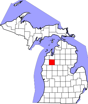 Location within the U.S. state of Michigan | |
 Michigan's location within the U.S. | |
| Coordinates: 44°20′N 85°35′W | |
| Country | |
| State | |
| Founded | 1840 (created) 1869 (organized)[1][2] |
| Named for | County Wexford, Ireland |
| Seat | Cadillac |
| Largest city | Cadillac |
| Area | |
| • Total | 575.46 sq mi (1,490.4 km2) |
| • Land | 565.00 sq mi (1,463.3 km2) |
| • Water | 10.46 sq mi (27.1 km2) 1.8%% |
| Population | |
| • Estimate (2018) | 33,466 |
| • Density | 59.2/sq mi (22.9/km2) |
| Time zone | UTC−5 (Eastern) |
| • Summer (DST) | UTC−4 (EDT) |
| Congressional district | 4th |
| Website | www |
Wexford County is part of the Cadillac, MI Micropolitan Statistical Area, which also includes Missaukee County. It is considered to be part of Northern Michigan.
The county is the location of the first known sighting of the Michigan dogman.
History
The county was established by the Michigan Legislature in 1840 as Kautawaubet County,[5] after a Potawatomi phrase meaning "broken tooth," and the name of a local Potawatomi chief. In 1843, legislators renamed the county Wexford,[5] after County Wexford in Ireland. It was formally organized in 1869.[1]
Geography
The Manistee River flows westward through the upper part of Wexford County. The county terrain consists of low rolling hills, largely tree-covered.[6] The terrain slopes to the west,[7] with its highest point, Briar Hill in Manistee National Forest[8] at 1,706 (520m) ASL.
According to the US Census Bureau, the county has a total area of 575.46 sqmi (1,490 km²), of which 565.00 sqmi (1,463 km²) is land and 10.46 sqmi (27.1 km²) (1.8%) is water.[9]
Adjacent counties
- Grand Traverse County - north
- Kalkaska County - northeast
- Missaukee County - east
- Osceola County - southeast
- Lake County - southwest
- Manistee County - west
- Benzie County - northwest
Protected areas
- Brandy Brook Waterfowl Area
- Manistee National Forest (part)
- Mitchell State Park
Lakes[6]
- Hodenpyl Dam Pond
- Lake Cadillac
- Lake Gitchegumee
- Lake Mitchell
- Long Lake
- Round Lake (part)
Demographics
| Historical population | |||
|---|---|---|---|
| Census | Pop. | %± | |
| 1870 | 650 | — | |
| 1880 | 6,815 | 948.5% | |
| 1890 | 11,278 | 65.5% | |
| 1900 | 16,845 | 49.4% | |
| 1910 | 20,769 | 23.3% | |
| 1920 | 18,207 | −12.3% | |
| 1930 | 16,827 | −7.6% | |
| 1940 | 17,976 | 6.8% | |
| 1950 | 18,628 | 3.6% | |
| 1960 | 18,466 | −0.9% | |
| 1970 | 19,717 | 6.8% | |
| 1980 | 25,102 | 27.3% | |
| 1990 | 26,360 | 5.0% | |
| 2000 | 30,484 | 15.6% | |
| 2010 | 32,735 | 7.4% | |
| Est. 2018 | 33,466 | [10] | 2.2% |
| US Decennial Census[11] 1790-1960[12] 1900-1990[13] 1990-2000[14] 2010-2018[3] | |||
2000 census
As of the 2000 United States Census,[15] there were 30,484 people, 11,824 households, and 8,383 families in the county. The population density was 54/sqmi (20.8/km²). There were 14,872 housing units at an average density of 26.3/sqmi (10.2/km²). The racial makeup of the county was 97.29% White, 0.19% Black or African American, 0.74% Native American, 0.42% Asian, 0.03% Pacific Islander, 0.24% from other races, and 1.09% from two or more races. 1.01% of the population were Hispanic or Latino of any race. 21.4% were of German, 11.3% English, 9.5% American, 9.4% Irish, 6.1% Dutch, 5.8% Swedish and 5.3% Polish ancestry. 97.7% spoke English and 1.1% Spanish as their first language.
There were 11,824 households out of which 33.60% had children under the age of 18 living with them, 56.20% were married couples living together, 10.30% had a female householder with no husband present, and 29.10% were non-families. 24.20% of all households were made up of individuals and 10.10% had someone living alone who was 65 years of age or older. The average household size was 2.55 and the average family size was 3.00.
The county population contained 26.80% under the age of 18, 7.70% from 18 to 24, 28.10% from 25 to 44, 23.40% from 45 to 64, and 14.00% who were 65 years of age or older. The median age was 37 years. For every 100 females, there were 98.10 males. For every 100 females age 18 and over, there were 93.80 males.
The median income for a household in the county was $35,363, and the median income for a family was $39,915. Males had a median income of $31,198 versus $21,733 for females. The per capita income for the county was $17,144. About 7.70% of families and 10.30% of the population were below the poverty line, including 11.50% of those under age 18 and 8.50% of those age 65 or over.
Government
The county government operates the jail, maintains rural roads, operates the major local courts, keeps files of deeds and mortgages, maintains vital records, administers public health regulations, and participates with the state in the provision of welfare and other social services. The county board of commissioners controls the budget but has only limited authority to make laws or ordinances. In Michigan, most local government functions — police and fire, building and zoning, tax assessment, street maintenance, etc. — are the responsibility of individual cities and townships.
Elected officials
- Prosecuting Attorney: Jason J. Elmore
- Sheriff: Trent Taylor
- County Clerk: Alaina M. Nyman
- County Treasurer: Kristi Nottingham
- Register of Deeds: Lorie L. Sorensen
- Drain Commissioner: Michael J. Solomon
- County Surveyor: Craig J. Pullen
(information as of July 2019)[16]
Politics
Wexford county is one of the few counties to have given majorities to both the first Republican candidate, John C. Frémont,[17] and to John McCain in his 2008 presidential campaign.[18] The county also twice favored Democrat Bill Clinton.[19]
| Year | Republican | Democratic | Third Parties |
|---|---|---|---|
| 2016 | 65.1% 10,000 | 28.9% 4,436 | 6.1% 934 |
| 2012 | 56.7% 8,450 | 41.5% 6,184 | 1.8% 264 |
| 2008 | 51.1% 8,044 | 46.9% 7,379 | 2.0% 318 |
| 2004 | 59.1% 8,966 | 39.8% 6,034 | 1.1% 160 |
| 2000 | 55.6% 7,215 | 41.0% 5,326 | 3.4% 441 |
| 1996 | 40.9% 4,866 | 46.4% 5,510 | 12.7% 1,512 |
| 1992 | 37.3% 4,696 | 38.9% 4,894 | 23.7% 2,985 |
| 1988 | 58.1% 6,043 | 41.2% 4,287 | 0.7% 76 |
| 1984 | 67.9% 7,279 | 31.7% 3,398 | 0.4% 38 |
| 1980 | 54.0% 6,027 | 37.4% 4,173 | 8.6% 960 |
| 1976 | 55.0% 5,670 | 43.8% 4,519 | 1.2% 128 |
| 1972 | 61.4% 5,221 | 35.9% 3,048 | 2.7% 230 |
| 1968 | 56.4% 4,364 | 36.6% 2,832 | 7.0% 544 |
| 1964 | 40.5% 3,016 | 59.3% 4,414 | 0.2% 16 |
| 1960 | 65.0% 5,262 | 34.7% 2,807 | 0.3% 27 |
| 1956 | 65.8% 5,052 | 33.9% 2,604 | 0.4% 27 |
| 1952 | 69.0% 5,569 | 29.8% 2,407 | 1.2% 97 |
| 1948 | 57.1% 3,833 | 39.2% 2,635 | 3.7% 249 |
| 1944 | 61.2% 4,074 | 37.4% 2,489 | 1.4% 93 |
| 1940 | 59.0% 4,322 | 40.2% 2,947 | 0.8% 57 |
| 1936 | 44.4% 3,153 | 53.1% 3,771 | 2.6% 185 |
| 1932 | 50.3% 3,425 | 47.8% 3,251 | 1.9% 128 |
| 1928 | 84.5% 4,825 | 14.9% 853 | 0.5% 30 |
| 1924 | 77.5% 3,926 | 11.7% 592 | 10.9% 550 |
| 1920 | 73.0% 3,406 | 23.5% 1,095 | 3.5% 163 |
| 1916 | 55.2% 2,333 | 39.8% 1,683 | 5.0% 210 |
| 1912 | 26.5% 1,075 | 20.2% 817 | 53.3% 2,162 |
| 1908 | 72.0% 2,886 | 20.7% 831 | 7.3% 294 |
| 1904 | 76.4% 3,003 | 17.6% 690 | 6.1% 239 |
| 1900 | 67.8% 2,519 | 27.3% 1,014 | 5.0% 185 |
| 1896 | 58.3% 2,036 | 38.9% 1,359 | 2.8% 99 |
| 1892 | 49.9% 1,388 | 41.6% 1,156 | 8.5% 237 |
| 1888 | 54.0% 1,437 | 40.0% 1,065 | 6.1% 161 |
| 1884 | 54.8% 1,220 | 39.4% 876 | 5.8% 130 |
Tourism
There are many attractions and hot spots in Wexford County. The Manistee National Forest is one recreation site. The Manistee River is used by fishermen, kayakers, and canoers. There are many lakes; the largest are Cadillac and Mitchell. Two hundred miles of snowmobile trails are maintained by the Cadillac Winter Promotions volunteer group. There are at least eight golf courses near Cadillac. There are several museums near Cadillac. The Wexford Civic Center is a 4,000 capacity arena, 300 capacity hockey facility, 300 capacity grand stand, and several buildings for agricultural shows and expos.
Communities

Other unincorporated communities
- Benson
- Garletts Corner
- Hoxeyville
- Meauwataka
- Sherman
- Walton (part)
- Yuma
Historical markers
There are ten recognized Michigan historical markers in the county:[21]
- Battle of Manton
- Caberfae Ski Resort
- Cadillac Carnegie Library
- Charles T. Mitchell House
- Clam Lake Canal
- Cobbs & Mitchell Building
- Cobbs and Mitchell Mill No.1
- First Wexford County Courthouse
- Greenwood Disciples of Christ Church
- Shay Locomotive
See also
- List of Michigan State Historic Sites in Wexford County, Michigan
- National Register of Historic Places listings in Wexford County, Michigan
References
- "Bibliography on Wexford County". Clarke Historical Library, Central Michigan University. Retrieved January 23, 2013.
- Cadillac History Archived February 29, 2012, at the Wayback Machine
- "State & County QuickFacts". United States Census Bureau. Retrieved August 29, 2013.
- "Find a County". National Association of Counties. Retrieved June 7, 2011.
- Newberry Library. "Michigan: Individual County Chronologies". Atlas of County Historical Boundaries. Retrieved November 4, 2016.
- Wexford County MI - Google Maps (accessed 10 July 2019)
- Find an Altitude/Wexford County MI (accessed 10 July 2019)
- Brian Hill, Michigan (PeakBagger.com) Accessed 10 July 2019
- "2010 Census Gazetteer Files". US Census Bureau. August 22, 2012. Archived from the original on November 13, 2013. Retrieved September 28, 2014.
- "Population and Housing Unit Estimates". Retrieved 10 July 2019.
- "US Decennial Census". US Census Bureau. Retrieved September 28, 2014.
- "Historical Census Browser". University of Virginia Library. Retrieved September 28, 2014.
- "Population of Counties by Decennial Census: 1900 to 1990". United States Census Bureau. Retrieved September 28, 2014.
- "Census 2000 PHC-T-4. Ranking Tables for Counties: 1990 and 2000" (PDF). US Census Bureau. Retrieved September 28, 2014.
- "U.S. Census website". US Census Bureau. Retrieved January 31, 2008.
- Wexford County Directory (accessed 10 July 2019)
- "1856 Presidential Election Statistics". uselectionatlas.org.
- "Dave Leip's Atlas of U.S. Presidential Elections - State Data". uselectionatlas.org.
- The New York Times electoral map, 2008 (Zoom in on Michigan)
- US Election Results
- "Michigan Historical Markers". michmarkers.com.
External links
- Wexford County
- Wexford County Fact Book
- Chapter XVII Wexford County in A history of northern Michigan and its people by Perry F. Powers ; assisted by H.G. Cutler. Powers, Perry Francis, 1857–1945. Chicago: Lewis Publishing Co., 1912. p. 404
- History of Wexford County, Michigan, comp. by John H. Wheeler, Logansport, Ind.:B. F. Bowen, 1903.
- Wexford County Sheriff's Office
Places adjacent to Wexford County, Michigan | ||||||||||
|---|---|---|---|---|---|---|---|---|---|---|
| ||||||||||
Municipalities and communities of Wexford County, Michigan, United States | ||
|---|---|---|
| Cities | Map of Michigan highlighting Wexford County.svg | |
| Villages | ||
| Charter township | ||
| General law townships | ||
| CDPs | ||
| Other unincorporated communities | ||
| Central cities | |
|---|---|
| Counties | |
| Geography | |
| Transportation | |
| Economy | |
| |

| Authority control |
|
|---|