Iosco County, Michigan
Iosco County is a county in the U.S. state of Michigan; its eastern border is formed by Lake Huron. As of the 2010 census, the population was 25,887.[2] The county seat is Tawas City.[3]
Iosco County | |
|---|---|
 | |
Seal | |
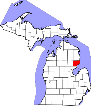 Location within the U.S. state of Michigan | |
 Michigan's location within the U.S. | |
| Coordinates: 44°17′N 83°20′W | |
| Country | |
| State | |
| Founded | 1840 (as "Kanotin") 1857 organized[1] |
| Seat | Tawas City |
| Largest city | East Tawas |
| Area | |
| • Total | 1,890 sq mi (4,900 km2) |
| • Land | 549 sq mi (1,420 km2) |
| • Water | 1,341 sq mi (3,470 km2) 71%% |
| Population | |
| • Estimate (2018) | 25,081 |
| • Density | 47/sq mi (18/km2) |
| Time zone | UTC−5 (Eastern) |
| • Summer (DST) | UTC−4 (EDT) |
| Congressional district | 5th |
Etymology of Iosco
Iosco is traditionally said to be a Native American word meaning "water of light."[4] However, it was coined as a pseudo-Native American name by Henry Rowe Schoolcraft, an American geographer and ethnologist who served as the US Indian agent in Michigan in the late 19th century. He named several counties and towns during the state's formative years.[5]
History
The county was created by the Michigan Legislature in 1840 as Kanotin County, and renamed Iosco County in 1843. It was administered by a succession of other Michigan counties prior to the organization of county government in 1857.A majority of the population used to be Chippewa Indians, the area offered shelter from tall white pines, and food from the river and lake. Iosco County was cut from a piece of land seded from the Chippewa Indians to the United States Government. Then, in the 1800s when the lumber boom hit, many more people moved to the area.[6][1]
The 400-acre Alabaster Historic District, listed on the National Register of Historic Places, is associated with an operating gypsum open-pit mine south of Tawas City. The large company town included internal rail lines for transportation and a tramway extending over Lake Huron on long piers for loading gypsum onto ships. Started in 1862, the mine supplied gypsum for temporary buildings constructed in Chicago at the World Columbian Exposition of 1893.[7] At present, two companies continue to mine gypsum in Iosco County.
In 2009, Alabaster Township formed the non-profit Alabaster Wind Power Development Corp. to conduct the necessary 2-year studies of wind data at this site as a potential location for the development of wind turbines. It proposed using 10 large tramway platforms which extend more than 6,000 feet into the lake to gauge winds. The turbines could be built on the tramways. At the time, the federal government was offering subsidies for such studies and development of alternative energy projects.[8]
Geography
According to the US Census Bureau, the county has an area of 1,890 square miles (4,900 km2), of which 549 square miles (1,420 km2) is land and 1,341 square miles (3,470 km2) (71%) is water.[9] The county is considered to be part of Northern Michigan. In total, it covers about 6,361,837 acres.
Geographic features
- Lumberman's Monument
- Canoer's memorial
- 60 Lakes Area - Located near Hale
- Iargo Springs
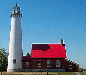
- Tawas Point Light House - First lit in 1853
- Tawas Bay
- Pine River – rises in Alcona County and flows into Iosco County, where it empties into Van Etten Lake at 44°29′38″N 83°23′16″W northwest of Oscoda.[10]
- Au Sable River
- Tuttle Marsh Wildlife Area
- Van Etten Lake
- Tawas Lake
- Foote Dam Pond
- Au Sable State Forest (partial) – the Grayling Fire Management Unit[11] consists of Alcona, Crawford, and Oscoda Counties, and northern Iosco county.
Major highways


- River Road National Scenic Byway – starts at M-65 and runs parallel with the Au Sable River for 23 miles (37 km) eastward to US 23 in Oscoda, Michigan. It is a designated National Scenic Byway.[13] It passes the Lumberman's Monument.
Adjacent counties
- Alcona County - north
- Arenac County - southwest
- Ogemaw County - west
- Oscoda County - northwest
National protected area
- Huron National Forest (part)
Demographics
| Historical population | |||
|---|---|---|---|
| Census | Pop. | %± | |
| 1860 | 175 | — | |
| 1870 | 3,163 | 1,707.4% | |
| 1880 | 6,873 | 117.3% | |
| 1890 | 15,224 | 121.5% | |
| 1900 | 10,246 | −32.7% | |
| 1910 | 9,753 | −4.8% | |
| 1920 | 8,199 | −15.9% | |
| 1930 | 7,517 | −8.3% | |
| 1940 | 8,560 | 13.9% | |
| 1950 | 10,906 | 27.4% | |
| 1960 | 16,505 | 51.3% | |
| 1970 | 24,905 | 50.9% | |
| 1980 | 28,349 | 13.8% | |
| 1990 | 30,209 | 6.6% | |
| 2000 | 27,339 | −9.5% | |
| 2010 | 25,887 | −5.3% | |
| Est. 2018 | 25,081 | [14] | −3.1% |
| US Decennial Census[15] 1790-1960[16] 1900-1990[17] 1990-2000[18] 2010-2018[2] | |||
As of the 2000 United States Census,[19] there were 27,339 people, 11,727 households, and 7,857 families in the county. Most of the population is located on the shoreline along US-23,East Tawas, Tawas City, and Oscoda County. The population density was 50 people per square mile (19/km²). There were 20,432 housing units at an average density of 37 per square mile (14/km²). The county's racial makeup was 96.92% White, 0.41% Black or African American, 0.66% Native American, 0.46% Asian, 0.05% Pacific Islander, 0.23% from other races, and 1.27% from two or more races. 0.98% of the population were Hispanic or Latino of any race. 23.2% were of German, 12.3% English, 10.6% Irish, 9.9% American, 8.3% Polish and 7.1% French ancestry. 97.4% spoke English and 1.0% Spanish as their first language.
There were 11,727 households out of which 24.90% had children under the age of 18 living with them, 55.20% were married couples living together, 8.40% had a female householder with no husband present, and 33.00% were non-families. 28.60% of all households were made up of individuals and 14.00% had someone living alone who was 65 years of age or older. The average household size was 2.30 and the average family size was 2.79.
The county population included 22.40% under the age of 18, 5.40% from 18 to 24, 23.40% from 25 to 44, 27.30% from 45 to 64, and 21.60% who were 65 years of age or older. The median age was 44 years. For every 100 females there were 96.30 males. For every 100 females age 18 and over, there were 93.60 males.
The median income for a household in the county was $31,321, and the median income for a family was $37,452. Males had a median income of $30,338 versus $21,149 for females. The per capita income for the county was $17,115. About 9.50% of families and 12.70% of the population were below the poverty line, including 18.50% of those under age 18 and 7.60% of those age 65 or over.
Government
The county government operates the jail, maintains rural roads, operates the major local courts, records deeds, mortgages, and vital records, administers public health regulations, and participates with the state in the provision of social services. The county board of commissioners controls the budget, with limited authority to make laws or ordinances. In Michigan, most local government functions — police and fire, building and zoning, tax assessment, street maintenance, etc. — are the responsibility of individual cities and townships.
Elected officials
Iosco County has been reliably Republican from the beginning. Since 1884, the Republican Party nominee has carried the county vote in 79% of the elections (27 of 34 elections).
| Year | Republican | Democratic | Third Parties |
|---|---|---|---|
| 2016 | 62.1% 8,345 | 32.4% 4,345 | 5.5% 739 |
| 2012 | 51.6% 6,909 | 46.6% 6,242 | 1.8% 234 |
| 2008 | 46.3% 6,583 | 51.4% 7,309 | 2.3% 333 |
| 2004 | 52.1% 7,301 | 46.8% 6,557 | 1.1% 148 |
| 2000 | 48.0% 6,345 | 49.2% 6,505 | 2.8% 372 |
| 1996 | 35.5% 4,410 | 50.2% 6,240 | 14.3% 1,774 |
| 1992 | 36.4% 4,912 | 39.8% 5,369 | 23.8% 3,211 |
| 1988 | 59.2% 7,234 | 40.3% 4,929 | 0.5% 62 |
| 1984 | 67.0% 7,907 | 32.6% 3,850 | 0.4% 47 |
| 1980 | 56.5% 6,680 | 36.0% 4,255 | 7.4% 880 |
| 1976 | 52.4% 5,500 | 46.4% 4,875 | 1.2% 123 |
| 1972 | 64.1% 5,750 | 34.2% 3,065 | 1.7% 156 |
| 1968 | 55.4% 4,068 | 34.5% 2,533 | 10.1% 739 |
| 1964 | 38.4% 2,704 | 61.6% 4,336 | 0.1% 4 |
| 1960 | 62.7% 4,308 | 37.1% 2,549 | 0.1% 9 |
| 1956 | 72.5% 4,385 | 27.5% 1,660 | 0.1% 3 |
| 1952 | 74.6% 3,772 | 25.2% 1,274 | 0.3% 13 |
| 1948 | 68.9% 2,599 | 29.6% 1,115 | 1.5% 58 |
| 1944 | 67.3% 2,340 | 32.4% 1,127 | 0.3% 12 |
| 1940 | 65.5% 2,504 | 34.1% 1,303 | 0.5% 18 |
| 1936 | 50.9% 1,768 | 44.5% 1,547 | 4.6% 160 |
| 1932 | 49.6% 1,581 | 47.1% 1,500 | 3.3% 105 |
| 1928 | 76.8% 1,873 | 22.6% 552 | 0.6% 14 |
| 1924 | 71.4% 1,713 | 12.7% 304 | 15.9% 381 |
| 1920 | 76.7% 2,013 | 20.9% 548 | 2.4% 63 |
| 1916 | 56.0% 984 | 41.5% 729 | 2.5% 44 |
| 1912 | 28.9% 521 | 23.2% 418 | 47.9% 864 |
| 1908 | 63.0% 1,224 | 34.4% 668 | 2.6% 50 |
| 1904 | 75.3% 1,482 | 21.7% 426 | 3.1% 60 |
| 1900 | 66.4% 1,402 | 32.2% 679 | 1.4% 30 |
| 1896 | 60.3% 1,470 | 37.4% 912 | 2.4% 58 |
| 1892 | 49.6% 1,393 | 47.5% 1,336 | 2.9% 81 |
| 1888 | 45.5% 1,505 | 49.5% 1,639 | 5.0% 167 |
| 1884 | 52.8% 1,016 | 44.9% 864 | 2.2% 43 |
County elected officials
- Prosecuting Attorney: Gary W. Rapp
- Sheriff: Allan MacGregor
- County Clerk: Nancy J. Huebel Chief Deputy Clerk Kellie M. Flory
- County Treasurer: Elite Shellenbarger
- Register of Deeds: Ericka Earl
- Drain Commissioner: Gary Adams
County commissioners
- District 1: Robert Huebel III
- District 2: Jeff Johnston
- District 3: Mark McKulsky
- District 4: John Moehring
- District 5: Donald "Jay" O'Farrell
Education
Iosco County has four public school districts:
There are also three private elementary schools
- Emanuel Lutheran School (Tawas City)
- Holy Family School (East Tawas)
- Shady Grove School (Whittemore)
Alpena Community College offers college-level courses at its campus on the former Wurtsmith Air Force Base in Oscoda and local public school facilities.
Media
- The Iosco County News-Herald is the newspaper of record for Iosco County.[21]
- The Oscoda Press is a weekly newspaper serving northern Iosco County and southern Alcona County[22]
Communities
Cities
- East Tawas
- Tawas City (county seat)
- Whittemore
Other unincorporated communities
- Hale
- Long Lake
- National City
See also
- List of Michigan State Historic Sites in Iosco County, Michigan
- National Register of Historic Places listings in Iosco County, Michigan
References
- "Bibliography on Iosco County". Clarke Historical Library, Central Michigan University. Retrieved January 19, 2013.
- "State & County QuickFacts". US Census Bureau. Archived from the original on June 6, 2011. Retrieved August 27, 2013.
- "Find a County". National Association of Counties. Archived from the original on May 31, 2011. Retrieved June 7, 2011.
- Gannett, Henry (1905). The Origin of Certain Place Names in the United States. Govt. Print. Off. p. 165.
- "Michigan Counties". Michigan.gov. Archive.org. Archived from the original on March 13, 2009. Retrieved February 14, 2016.
- Newberry Library. "Michigan: Individual County Chronologies". Atlas of County Historical Boundaries. Retrieved November 4, 2016.
- "National Register Information System". National Register of Historic Places. National Park Service. July 9, 2010.
- Amy L. Payne, "Planners propose retrofitting old gypsum tramway for wind turbines on Lake Huron", MLive, Booth Mid-Michigan, February 26, 2009
- "2010 Census Gazetteer Files". US Census Bureau. August 22, 2012. Archived from the original on November 13, 2013. Retrieved September 25, 2014.
- U.S. Geological Survey Geographic Names Information System: Pine River (Iosco/Alcona Counties
- FMU definition
- "Picture of M-55 end point". state-ends.com. Archived from the original on December 11, 2007.
- River Road Scenic Byway at America's Byways.
- "Population and Housing Unit Estimates". Retrieved May 17, 2019.
- "US Decennial Census". US Census Bureau. Retrieved September 26, 2014.
- "Historical Census Browser". University of Virginia Library. Retrieved September 26, 2014.
- "Population of Counties by Decennial Census: 1900 to 1990". US Census Bureau. Retrieved September 26, 2014.
- "Census 2000 PHC-T-4. Ranking Tables for Counties: 1990 and 2000" (PDF). US Census Bureau. Retrieved September 26, 2014.
- "U.S. Census website". US Census Bureau. Retrieved January 31, 2008.
- US Election Atlas
- Iosco County News Herald home page
- "Iosco County News Herald". Iosco County News Herald.
Further reading
- Romig, Walter (1986) [1973]. Michigan Place Names: The History of the Founding and the Naming of More than Five Thousand Past and Present Michigan Communities. Great Lakes Books. Detroit: Wayne State University Press. ISBN 978-0814318386.
External links
- "Bibliography on Iosco County". Clarke Historical Library, Central Michigan University.
- County of Iosco, links, media, history, parks, and services
- Enchanted forest, Northern Michigan source for information, calendars, etc.
- Iosco County website
Places adjacent to Iosco County, Michigan | ||||||||||
|---|---|---|---|---|---|---|---|---|---|---|
| ||||||||||
Municipalities and communities of Iosco County, Michigan, United States | ||
|---|---|---|
| Cities | Map of Michigan highlighting Iosco County.svg | |
| Charter townships | ||
| General law townships | ||
| CDPs | ||
| Other unincorporated communities |
| |
| Central cities | |
|---|---|
| Counties | |
| Geography | |
| Transportation | |
| Economy | |
| |
