Manistee County, Michigan
Manistee County is a county located in the U.S. state of Michigan. As of the 2010 census, the population was 24,733.[2] The county seat is Manistee.[3] The name "Manistee" is from an Ojibwe word first applied to the principal river of the county.[1] The derivation is not certain,[4] but it may be from ministigweyaa, "river with islands at its mouth".[1][5][6] See also, List of Michigan county name etymologies and Kaministiquia River.
Manistee County | |
|---|---|
 | |
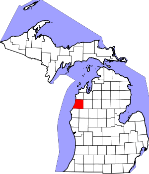 Location within the U.S. state of Michigan | |
 Michigan's location within the U.S. | |
| Coordinates: 44°18′N 86°19′W | |
| Country | |
| State | |
| Founded | 1840, organized in 1855[1] |
| Seat | Manistee |
| Largest city | Manistee |
| Area | |
| • Total | 1,281 sq mi (3,320 km2) |
| • Land | 542 sq mi (1,400 km2) |
| • Water | 738 sq mi (1,910 km2) 58%% |
| Population | |
| • Estimate (2018) | 24,528 |
| • Density | 46/sq mi (18/km2) |
| Time zone | UTC−5 (Eastern) |
| • Summer (DST) | UTC−4 (EDT) |
| Congressional district | 1st |
| Website | www |
History
The county was set off in 1840 and organized in 1855.[1]
Historical markers
There are thirteen recognized Michigan historical markers in the county:[7]
- Harriet Quimby / Childhood Home
- John J. Makinen Bottle House
- First Congregational Church, Manistee
- Great Fire of 1871
- Holy Trinity Episcopal Church
- Holy Trinity Episcopal Church Rectory
- Kaleva, Michigan
- Manistee City Library
- Manistee Fire Hall
- Our Saviour's Lutheran Church
- Ramsdell Theatre
- Trinity Lutheran Church [Arcadia]
- William Douglas House
Government
| Year | Republican | Democratic | Third Parties |
|---|---|---|---|
| 2016 | 54.6% 6,915 | 39.3% 4,979 | 6.1% 766 |
| 2012 | 46.3% 5,737 | 52.2% 6,473 | 1.6% 192 |
| 2008 | 42.4% 5,510 | 55.6% 7,235 | 2.0% 264 |
| 2004 | 49.4% 6,295 | 49.2% 6,272 | 1.4% 173 |
| 2000 | 47.3% 5,401 | 49.3% 5,639 | 3.4% 388 |
| 1996 | 36.1% 3,807 | 51.1% 5,383 | 12.8% 1,349 |
| 1992 | 30.0% 3,491 | 44.6% 5,193 | 25.5% 2,967 |
| 1988 | 52.6% 5,368 | 46.7% 4,765 | 0.8% 77 |
| 1984 | 61.5% 6,328 | 38.0% 3,917 | 0.5% 53 |
| 1980 | 52.9% 5,662 | 38.9% 4,164 | 8.2% 876 |
| 1976 | 54.6% 5,532 | 44.2% 4,479 | 1.2% 123 |
| 1972 | 57.2% 5,070 | 40.9% 3,625 | 1.9% 168 |
| 1968 | 48.2% 4,007 | 44.2% 3,671 | 7.6% 628 |
| 1964 | 34.6% 2,918 | 65.4% 5,520 | 0.1% 6 |
| 1960 | 54.1% 4,867 | 45.8% 4,122 | 0.1% 10 |
| 1956 | 63.7% 5,313 | 36.2% 3,014 | 0.1% 9 |
| 1952 | 62.5% 5,235 | 37.2% 3,114 | 0.3% 27 |
| 1948 | 52.9% 3,913 | 45.1% 3,339 | 2.0% 147 |
| 1944 | 54.4% 4,095 | 45.1% 3,398 | 0.5% 37 |
| 1940 | 52.1% 4,630 | 47.7% 4,242 | 0.2% 20 |
| 1936 | 42.0% 3,509 | 54.4% 4,542 | 3.6% 299 |
| 1932 | 40.1% 3,256 | 55.1% 4,475 | 4.7% 384 |
| 1928 | 60.7% 4,129 | 38.6% 2,624 | 0.7% 46 |
| 1924 | 58.1% 3,701 | 20.6% 1,314 | 21.3% 1,356 |
| 1920 | 47.7% 2,179 | 47.8% 2,184 | 4.5% 207 |
| 1916 | 50.2% 2,360 | 46.3% 2,177 | 3.6% 167 |
| 1912 | 26.3% 1,240 | 37.9% 1,790 | 35.8% 1,691 |
| 1908 | 56.8% 2,706 | 37.8% 1,799 | 5.5% 260 |
| 1904 | 67.4% 3,155 | 26.4% 1,235 | 6.2% 289 |
| 1900 | 56.3% 3,152 | 41.7% 2,336 | 1.9% 108 |
| 1896 | 50.7% 2,697 | 46.7% 2,487 | 2.7% 141 |
| 1892 | 35.4% 1,481 | 55.3% 2,310 | 9.3% 390 |
| 1888 | 39.2% 1,668 | 54.8% 2,328 | 6.0% 256 |
| 1884 | 38.5% 1,305 | 56.8% 1,926 | 4.8% 162 |
Manistee County was the only county in which James M. Cox and Charles Evans Hughes both won, as the chart above shows.
The county government operates the jail, maintains rural roads, operates the major local courts, keeps files of deeds and mortgages, maintains vital records, administers public health regulations, and participates with the state in the provision of welfare and other social services. The county board of commissioners controls the budget but has only limited authority to make laws or ordinances. In Michigan, most local government functions — police and fire, building and zoning, tax assessment, street maintenance, etc. — are the responsibility of individual cities and townships.
Elected officials
- Prosecuting Attorney: Jason Haag
- Sheriff: John O'Hagan
- County Clerk: Jill Nowak
- County Treasurer: Russell Pomeroy
- Register of Deeds: Penny Pepera
- Drain Commissioner: Ken Hilliard
- County Surveyor: Patrick Bentley
(information as of February 2012)
Geography
According to the U.S. Census Bureau, the county has a total area of 1,281 square miles (3,320 km2), of which 542 square miles (1,400 km2) is land and 738 square miles (1,910 km2) (58%) is water.[9] Manistee County is considered to be part of Northern Michigan.
Adjacent counties
- Benzie County - north
- Grand Traverse County - northeast
- Wexford County - east
- Lake County - southeast
- Mason County - south
- Manitowoc County, Wisconsin - southwest
- Kewaunee County, Wisconsin - west
National protected area
Transportation
Airport
Manistee County-Blacker Airport is approximately three miles (4.8 km) northeast of Manistee.
Demographics
| Historical population | |||
|---|---|---|---|
| Census | Pop. | %± | |
| 1860 | 975 | — | |
| 1870 | 6,074 | 523.0% | |
| 1880 | 12,532 | 106.3% | |
| 1890 | 24,230 | 93.3% | |
| 1900 | 27,856 | 15.0% | |
| 1910 | 26,688 | −4.2% | |
| 1920 | 20,899 | −21.7% | |
| 1930 | 17,409 | −16.7% | |
| 1940 | 18,450 | 6.0% | |
| 1950 | 18,524 | 0.4% | |
| 1960 | 19,042 | 2.8% | |
| 1970 | 20,094 | 5.5% | |
| 1980 | 23,019 | 14.6% | |
| 1990 | 21,265 | −7.6% | |
| 2000 | 24,527 | 15.3% | |
| 2010 | 24,733 | 0.8% | |
| Est. 2018 | 24,528 | [11] | −0.8% |
| U.S. Decennial Census[12] 1790-1960[13] 1900-1990[14] 1990-2000[15] 2010-2018[2] | |||
As of the census[16] of 2000, there were 24,527 people, 9,860 households, and 6,714 families residing in the county. The population density was 45 people per square mile (17/km²). There were 14,272 housing units at an average density of 26 per square mile (10/km²). The racial makeup of the county was 94.16% White, 1.63% Black or African American, 1.30% Native American, 0.32% Asian, 0.03% Pacific Islander, 1.01% from other races, and 1.55% from two or more races. 2.61% of the population were Hispanic or Latino of any race. 23.5% were of German, 16.9% Polish, 8.8% English, 8.8% American and 7.1% Irish ancestry. 96.2% spoke English and 2.3% Spanish as their first language.
There were 9,860 households out of which 27.40% had children under the age of 18 living with them, 55.10% were married couples living together, 9.10% had a female householder with no husband present, and 31.90% were non-families. 27.30% of all households were made up of individuals and 13.20% had someone living alone who was 65 years of age or older. The average household size was 2.37 and the average family size was 2.86.
In the county, the population was spread out with 22.60% under the age of 18, 6.70% from 18 to 24, 26.30% from 25 to 44, 26.30% from 45 to 64, and 18.10% who were 65 years of age or older. The median age was 42 years. For every 100 females there were 103.40 males. For every 100 females age 18 and over, there were 102.00 males.
The median income for a household in the county was $34,208, and the median income for a family was $41,664. Males had a median income of $33,211 versus $20,851 for females. The per capita income for the county was $17,204. About 6.90% of families and 10.30% of the population were below the poverty line, including 13.50% of those under age 18 and 7.90% of those age 65 or over.
See also
- List of Michigan State Historic Sites in Manistee County, Michigan
- National Register of Historic Places listings in Manistee County, Michigan
References
- "Bibliography on Manistee County". Clarke Historical Library, Central Michigan University. Retrieved January 20, 2013.
- "State & County QuickFacts". United States Census Bureau. Archived from the original on June 6, 2011. Retrieved August 28, 2013.
- "Find a County". National Association of Counties. Retrieved June 7, 2011.
- Bright, William (2004). Native American Place Names of the United States. Norman: Oklahoma University Press, pg. 265
- County place names Archived March 13, 2009, at the Wayback Machine
- "Manistee County, Michigan". 50-State Learning Resource Guide. Archived from the original on March 2, 2012. Retrieved April 7, 2009.
- "Michigan Historical Markers". Archived from the original on 2014-07-17. Retrieved 2008-01-08.
- http://uselectionatlas.org/RESULTS
- "2010 Census Gazetteer Files". United States Census Bureau. August 22, 2012. Archived from the original on November 13, 2013. Retrieved September 27, 2014.
- M-55 end point photos Archived December 11, 2007, at the Wayback Machine
- "Population and Housing Unit Estimates". Retrieved May 17, 2019.
- "U.S. Decennial Census". United States Census Bureau. Retrieved September 27, 2014.
- "Historical Census Browser". University of Virginia Library. Retrieved September 27, 2014.
- "Population of Counties by Decennial Census: 1900 to 1990". United States Census Bureau. Retrieved September 27, 2014.
- "Census 2000 PHC-T-4. Ranking Tables for Counties: 1990 and 2000" (PDF). United States Census Bureau. Retrieved September 27, 2014.
- "U.S. Census website". United States Census Bureau. Retrieved January 31, 2008.
Further reading
- "Bibliography on Manistee County". Clarke Historical Library, Central Michigan University. Retrieved January 20, 2013.
Places adjacent to Manistee County, Michigan | ||||||||||
|---|---|---|---|---|---|---|---|---|---|---|
| ||||||||||
Municipalities and communities of Manistee County, Michigan, United States | ||
|---|---|---|
| City | Map of Michigan highlighting Manistee County.svg | |
| Villages | ||
| Charter township | ||
| General law townships | ||
| CDPs | ||
| Other unincorporated communities | ||
| Indian reservation | ||
| Footnotes | ‡This populated place also has portions in an adjacent county or counties | |
| Central cities | |
|---|---|
| Counties | |
| Geography | |
| Transportation | |
| Economy | |
| |

| Authority control |
|
|---|