Alpena County, Michigan
Alpena County is a county in the U.S. state of Michigan. As of the 2010 census, the population was 29,598.[2] The county seat is Alpena.[3] It is considered to be part of Northern Michigan.
Alpena County | |
|---|---|
 | |
 Seal | |
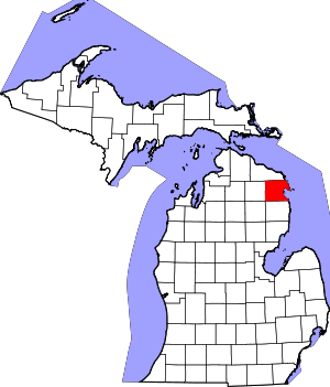 Location within the U.S. state of Michigan | |
 Michigan's location within the U.S. | |
| Coordinates: 45°02′N 83°12′W | |
| Country | |
| State | |
| Founded | February 7[1], 1857 |
| Seat | Alpena |
| Largest city | Alpena |
| Area | |
| • Total | 1,695 sq mi (4,390 km2) |
| • Land | 572 sq mi (1,480 km2) |
| • Water | 1,123 sq mi (2,910 km2) 66%% |
| Population | |
| • Estimate (2018) | 28,360 |
| • Density | 66/sq mi (25/km2) |
| Time zone | UTC−5 (Eastern) |
| • Summer (DST) | UTC−4 (EDT) |
| Congressional district | 1st |
| Website | www |
Alpena County comprises the Alpena, MI Micropolitan Statistical Area.
History

The county was created by the Michigan Legislature in 1840 as Anamickee County, then renamed in 1843 to Alpena County,[4] a pseudo-Native American word — a neologism coined by Henry Schoolcraft, meaning "a good partridge country."[1][5][6][7] This was part of a much larger effort to rename a great many of the Michigan counties at the time.[7] It was officially organized in 1857.[1][7]
Geography
According to the U.S. Census Bureau, the county has a total area of 1,695 square miles (4,390 km2), of which 572 square miles (1,480 km2) is land and 1,123 square miles (2,910 km2) (66%) is water.[8]
Alpena County is in the northeast of the mitten-shaped Lower Peninsula of Michigan. Lake Huron and Thunder Bay are to the east, Alcona County to the south, Oscoda County to the southwest, Montmorency County to the west, and Presque Isle County to the north. Most of the county is drained by the Thunder Bay River and its tributaries. The Mackinaw State Forest occupies large tracts of land in the county. The Thunder Bay National Marine Sanctuary is offshore adjacent to the county.
The 45th parallel bisects the county, meaning it is halfway between the North Pole and the equator.[9][10]
Several islands in Thunder Bay are part of the Michigan Islands National Wildlife Refuge. There are automated lighthouses on Middle Island and Thunder Bay Island.
Geographic features
- Thunder Bay River
- Long Lake
- Grand Lake
Glaciers shaped the area, creating a unique regional ecosystem. A large portion of the area is so-called Grayling outwash plain, consisting of broad outwash plain including sandy ice-disintegration ridges; jack pine barrens, some white pine-red pine forest, and northern hardwood forests. Large lakes were created by glacial action.[11] Some of the inland lakes are truly massive.[12]
Adjacent counties
- Alcona County - south
- Oscoda County - southwest
- Montmorency County - west
- Presque Isle County - north
Major highways


National protected area
Demographics
| Historical population | |||
|---|---|---|---|
| Census | Pop. | %± | |
| 1860 | 290 | — | |
| 1870 | 2,756 | 850.3% | |
| 1880 | 8,789 | 218.9% | |
| 1890 | 15,581 | 77.3% | |
| 1900 | 18,254 | 17.2% | |
| 1910 | 19,965 | 9.4% | |
| 1920 | 17,869 | −10.5% | |
| 1930 | 18,574 | 3.9% | |
| 1940 | 20,766 | 11.8% | |
| 1950 | 22,189 | 6.9% | |
| 1960 | 28,556 | 28.7% | |
| 1970 | 30,708 | 7.5% | |
| 1980 | 32,315 | 5.2% | |
| 1990 | 30,605 | −5.3% | |
| 2000 | 31,314 | 2.3% | |
| 2010 | 29,598 | −5.5% | |
| Est. 2018 | 28,360 | [13] | −4.2% |
| U.S. Decennial Census[14] 1790-1960[15] 1900-1990[16] 1990-2000[17] 2010-2018[2] | |||
The 2010 United States Census[18] indicates Alpena County had a 2010 population of 29,598. This is a decrease of -1,716 people from the 2000 United States Census. Overall, the county had a -5.5% growth rate during this ten-year period. In 2010 there were 12,791 households and 8,164 families in the county. The population density was 51.8 per square mile (20.0 square kilometers). There were 16,053 housing units at an average density of 28.1 per square mile (10.8 square kilometers). 97.5% of the population were White, 0.5% Native American, 0.5% Asian, 0.3% Black or African American, 0.1% of some other race and 1.1% of two or more races. 1.0% were Hispanic or Latino (of any race). 26.8% were of German, 19.5% Polish, 12.9% French, French Canadian or Cajun, 8.1% English, 6.4% Irish and 5.7% American ancestry.[19]
There were 12,791 households out of which 25.3% had children under the age of 18 living with them, 50.0% were husband and wife families, 9.8% had a female householder with no husband present, 36.2% were non-families, and 30.8% were made up of individuals. The average household size was 2.27 and the average family size was 2.81.
In the county, the population was spread out with 20.9% under age of 18, 7.4% from 18 to 24, 20.8% from 25 to 44, 31.5% from 45 to 64, and 19.5% who were 65 years of age or older. The median age was 46 years. For every 100 females there were 96.4 males. For every 100 females age 18 and over, there were 94.1 males.
The 2010 American Community Survey 3-year estimate[18] indicates the median income for a household in the county was $36,242 and the median income for a family was $46,718. Males had a median income of $27,002 versus $15,670 for females. The per capita income for the county was $21,713. About 2.5% of families and 16.9% of the population were below the poverty line, including 27.2% of those under the age 18 and 10.0% of those age 65 or over.
Religion
Alpena County is part of the Roman Catholic Diocese of Gaylord.[20]
Government
| Year | Republican | Democratic | Third Parties |
|---|---|---|---|
| 2016 | 61.6% 9,090 | 33.0% 4,877 | 5.4% 801 |
| 2012 | 51.8% 7,298 | 46.5% 6,549 | 1.7% 244 |
| 2008 | 47.1% 7,125 | 51.0% 7,705 | 1.9% 294 |
| 2004 | 50.4% 7,665 | 48.7% 7,407 | 0.9% 139 |
| 2000 | 47.9% 6,769 | 49.9% 7,053 | 2.2% 310 |
| 1996 | 33.5% 4,525 | 52.7% 7,114 | 13.7% 1,853 |
| 1992 | 32.4% 4,878 | 45.8% 6,894 | 21.9% 3,297 |
| 1988 | 51.1% 6,664 | 48.6% 6,341 | 0.4% 49 |
| 1984 | 61.3% 8,212 | 38.3% 5,136 | 0.4% 49 |
| 1980 | 49.9% 6,901 | 42.2% 5,834 | 7.9% 1,097 |
| 1976 | 49.6% 6,380 | 49.0% 6,310 | 1.4% 176 |
| 1972 | 55.1% 6,513 | 43.1% 5,104 | 1.8% 214 |
| 1968 | 50.8% 5,717 | 42.5% 4,788 | 6.7% 756 |
| 1964 | 34.5% 3,954 | 65.5% 7,508 | 0.1% 10 |
| 1960 | 56.4% 6,573 | 43.5% 5,071 | 0.1% 9 |
| 1956 | 70.2% 7,142 | 29.8% 3,033 | 0.0% 2 |
| 1952 | 66.3% 6,248 | 33.3% 3,134 | 0.4% 39 |
| 1948 | 60.3% 4,313 | 38.4% 2,743 | 1.3% 96 |
| 1944 | 60.8% 4,453 | 39.0% 2,856 | 0.3% 18 |
| 1940 | 57.2% 4,822 | 42.7% 3,597 | 0.2% 13 |
| 1936 | 50.0% 3,536 | 45.7% 3,231 | 4.4% 309 |
| 1932 | 46.0% 3,222 | 50.8% 3,562 | 3.2% 222 |
| 1928 | 63.4% 3,467 | 36.3% 1,984 | 0.3% 15 |
| 1924 | 75.8% 4,628 | 15.5% 948 | 8.7% 531 |
| 1920 | 63.4% 3,467 | 34.6% 1,893 | 2.0% 110 |
| 1916 | 57.9% 2,020 | 39.9% 1,392 | 2.2% 75 |
| 1912 | 20.0% 709 | 31.2% 1,105 | 48.9% 1,733 |
| 1908 | 68.1% 2,358 | 27.4% 949 | 4.5% 157 |
| 1904 | 69.4% 2,498 | 25.2% 907 | 5.4% 196 |
| 1900 | 59.3% 2,283 | 37.3% 1,435 | 3.4% 129 |
| 1896 | 51.0% 1,777 | 47.8% 1,665 | 1.2% 40 |
| 1892 | 49.1% 1,526 | 49.4% 1,536 | 1.5% 45 |
| 1888 | 47.1% 1,486 | 47.7% 1,504 | 5.1% 162 |
| 1884 | 43.9% 927 | 53.3% 1,127 | 2.8% 59 |
The county government operates the jail, maintains rural roads, operates the major local courts, keeps files of deeds and mortgages, maintains vital records, administers public health regulations, and participates with the state in the provision of welfare and other social services. The county board of commissioners controls the budget but has only limited authority to make laws or ordinances. In Michigan, most local government functions — police and fire, building and zoning, tax assessment, street maintenance, etc. — are the responsibility of individual cities and townships.
The County operates three parks (and camp grounds) with beaches on local lakes,[22] namely Beaver Lake Park in Lachine;[23] Long Lake Park in Alpena;[24] and Sunken Lake Park in Posen[25]
Elected officials
- Probate Judge: Thomas J. LaCross[26][27]
- Prosecuting Attorney: K. Edward Black[27][28]
- Sheriff: Steven Kieliszewski[27][28]
- County Clerk: Bonnie Friedrichs[27][28]
- County Treasurer: Joelyn McCallum[27][28]
- Register of Deeds: Kathy J. Matash[27][28]
- Drain Commissioner: Don Wood[27]
(information as of May 2012)
Events
There are many recurring local activities.[29]
- Alpena Blues Festival, late June at The Alpena Fair Grounds and Merchant Building.[30]
- Alpena County Fair, Alpena County Fairgrounds.
- Alpena Earth Day Celebration, April 22. Location in Alpena varies. Food, games.[31]
- Besser Museum Log Cabin Day, last Sunday in June. Approved by the Michigan legislature passed a bill to make Log Cabin Day an annual event to be held on the last Sunday in June. The Besser Museum for Northeast Michigan spotlights their own two log cabins on this day and celebrates by offering old fashioned, family activities.
- Great Lakes Lighthouse Festival, second weekend in October.[32]
- Habitat for Humanity-Alpena Area "Drive to Build" Charity Golf Outing
- Lafarge Downtown Alpena Riverfest, in mid-June. Family event centered on the Thunder Bay River, celebrating Alpena's lumbering history. Professional lumberjack shows, entertainment, music, storytelling, chainsaw carving, food, and games.
- Michigan Brown Trout Festival, a week in mid-July.
- Ramblin' Rods Car Show, second weekend in August at Mich-E-Kewis Park, Alpena.[33]
- Shelter, Inc. "Garden Walk", nine Gardens, all in Alpena, MI. 49707
- Sunrise Side Heritage Bike Ride, Second weekend in September. Ride Along Lake Huron Shoreline (US - 23) to Mackinac Bridge then South to West Branch (M-33).
- Thunder Bay Arts Council's "Art on the Bay" at beautiful Bay View Park in Alpena. A Juried Fine Arts and Fine Crafts Fair which coincides with The Michigan Brown Trout Festival. There are over one Hundred and Fifty Artist will fill more than 180 booths with their original artwork.
- Thunder Bay Maritime Festival takes place at 500 W. Fletcher Street, Alpena, MI. 49707. It is presented by the Thunder Bay National Marine Sanctuary and Underwater Preserve.
- Youth Sailing Instruction and Training is offered by the Alpena Yacht Club.[34]
Media
The Alpena News[35] is the daily newspaper of record for much of Northeast lower peninsula of Michigan. For a complete list of other media, see Alpena, Michigan.
Arts and culture
Historical markers
There are seven recognized historical markers in the county:[37]
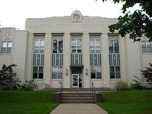
- Alpena County Courthouse
- Alpena City Hall
- The Daniel Carter Family
- First Congregational Church [Alpena]
- Monarch Mill
- St. Bernard Catholic Church
- World's Largest Cement Plant
Communities
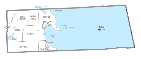
City
- Alpena (county seat)
Village
- Hillman (partial)
Charter township
Civil townships
Census-designated place
Other unincorporated communities
- Bolton
- Cathro
- Herron
- Hubbard Lake
- Lachine
- Leer
- Spratt
See also
- Alpena Community College
- List of Michigan State Historic Sites in Alpena County, Michigan
- National Register of Historic Places listings in Alpena County, Michigan
References
- "Bibliography on Alpena County". Clarke Historical Library, Central Michigan University. Retrieved November 4, 2016.
- "State & County QuickFacts". United States Census Bureau. Archived from the original on June 6, 2011. Retrieved August 26, 2013.
- "Find a County". National Association of Counties. Archived from the original on May 31, 2011. Retrieved June 7, 2011.
- Newberry Library. "Michigan: Individual County Chronologies". Atlas of County Historical Boundaries. Retrieved November 4, 2016.
- Romig, Walter (October 1, 1986) [1973]. Michigan Place Names: The History of the Founding and the Naming of More Than Five Thousand Past and Present Michigan Communities. Great Lakes Books Series (Paperback). Detroit, Michigan: Wayne State University Press. ISBN 081431838X. ISBN 978-0814318386.
- Herron, Catherine (1962). Herron, Nelson R. (ed.). "A History of the Place Names of Alpena County". Wilderness Chronicle (published 1991–1992) (19–21). Archived from the original on July 15, 2004.
- "Michigan government on place names". Archived from the original on July 28, 2009. Retrieved January 18, 2013.
- "2010 Census Gazetteer Files". United States Census Bureau. August 22, 2012. Archived from the original on November 13, 2013. Retrieved September 18, 2014.
- "45th Parallel North America". wurlington-bros.com.
- "Google Groups". keyhole.com.
- "NPWRC :: Regional Landscape". usgs.gov. Archived from the original on 2013-06-25.
- Top 20 Michigan inland lakes. Archived 2008-04-10 at the Wayback Machine
- "Population and Housing Unit Estimates". Retrieved May 16, 2019.
- "U.S. Decennial Census". United States Census Bureau. Retrieved September 18, 2014.
- "Historical Census Browser". University of Virginia Library. Retrieved September 18, 2014.
- "Population of Counties by Decennial Census: 1900 to 1990". United States Census Bureau. Retrieved September 18, 2014.
- "Census 2000 PHC-T-4. Ranking Tables for Counties: 1990 and 2000" (PDF). United States Census Bureau. Retrieved September 18, 2014.
- "U.S. Census website". United States Census Bureau. Retrieved March 11, 2012.
- Data Access and Dissemination Systems (DADS). "U.S. Census website". census.gov.
- "The Diocese of Gaylord, Michigan : A Diocese of the Roman Catholic Church - Diocese of Gaylord". dioceseofgaylord.org.
- Leip, David. "Dave Leip's Atlas of U.S. Presidential Elections". uselectionatlas.org. Retrieved 11 April 2018.
- Alpena County Parks Archived 2007-12-08 at the Wayback Machine
- Beaver Lake Park Archived 2007-12-09 at the Wayback Machine
- Long Lake Park Archived 2007-12-09 at the Wayback Machine
- Sunken Lake Park Archived 2007-12-09 at the Wayback Machine
- Michigan Bar Journal, April 2012, p. 59
- Alpena County Directory (PDF). 2011–2012. Retrieved May 1, 2012.
- Michigan Bar Journal, April 2012, p. 113
- Alpena Chamber of Commerce calendar of events. Archived 2007-12-12 at the Wayback Machine
- "Alpena Blues Festival". alpenablues. Archived from the original on 2015-05-31. Retrieved 2018-10-13.
- "Log into Facebook - Facebook". Facebook.
- "Lighthouse Festival - Lighthouse Festival". Lighthouse Festival. Archived from the original on 2003-04-02.
- Reblin'Rods Car Show Archived 2008-11-22 at the Wayback Machine
- "Alpena Yacht Club - Sailing School - Alpena, Michigan". alpenayachtclub.com. Archived from the original on 2016-01-13.
- "News, Sports, Jobs - The Alpena News". www.thealpenanews.com. Retrieved 11 April 2018.
- Neighbor Hub. "Home - Besser Museum". bessermuseum.org.
- "Michigan Historical Markers". michmarkers.com. Archived from the original on 2010-03-15. Retrieved 2008-01-08.
External links
| Wikimedia Commons has media related to Alpena County, Michigan. |
- Alpena County Government
- Alpena County parks
- "Bibliography on Alpena County". Clarke Historical Library, Central Michigan University. Retrieved January 18, 2013.
- Alpena County Soil Survey, U.S. Dept. of Agriculture, Michigan State University Extension Service (soil, history, good general information)
- Besser Museum home page
- Clarke Historical Library, Central Michigan University, Bibliography on Alpena County
- Enchanted forest, Northern Michigan source for information, calendars, etc.
- Thunder Bay Marine Sanctuary, Underwater Preserve and Museum
Places adjacent to Alpena County, Michigan | ||||||||||
|---|---|---|---|---|---|---|---|---|---|---|
| ||||||||||
Municipalities and communities of Alpena County, Michigan, United States | ||
|---|---|---|
| City | Map of Michigan highlighting Alpena County.svg | |
| Village | ||
| Charter township | ||
| Civil townships | ||
| CDP | ||
| Other unincorporated communities |
| |
| Footnotes | ‡This populated place also has portions in an adjacent county or counties | |
| Central cities | |
|---|---|
| Counties | |
| Geography | |
| Transportation | |
| Economy | |
| |

| Authority control |
|
|---|