Grand Traverse County, Michigan
Grand Traverse County is a county located in the U.S. state of Michigan. As of the 2010 census, the population was 86,986.[2] The county seat is Traverse City.[3]
Grand Traverse County | |
|---|---|
 Grand Traverse County Courthouse in Traverse City | |
 Flag Logo | |
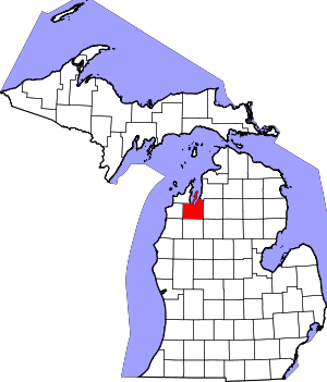 Location within the U.S. state of Michigan | |
 Michigan's location within the U.S. | |
| Coordinates: 44°44′N 85°33′W | |
| Country | |
| State | |
| Founded | 1851[1] |
| Named for | Grand Traverse Bay |
| Seat | Traverse City |
| Largest city | Traverse City |
| Area | |
| • Total | 601 sq mi (1,560 km2) |
| • Land | 464 sq mi (1,200 km2) |
| • Water | 137 sq mi (350 km2) 23%% |
| Population | |
| • Estimate (2018) | 92,573 |
| • Density | 198/sq mi (76/km2) |
| Time zone | UTC−5 (Eastern) |
| • Summer (DST) | UTC−4 (EDT) |
| Congressional district | 1st |
| Website | www |
According to the United States Census Bureau, it is estimated that the population of Grand Traverse County in July 1, 2018 was 92,573.
Grand Traverse County is part of the Traverse City, MI Micropolitan Statistical Area, which also includes Benzie, Kalkaska, and Leelanau counties.
Interlochen, home of the Interlochen Center for the Arts is located in Green Lake Township.
Grand Traverse County was originally known as Omeena County.
History
Early history
In 1840, the county was separated from Mackinac County and originally named Omeena County, later to be renamed Grand Traverse County, after Grand Traverse.
Grand Traverse County was organized by an act of the state legislature on April 7, 1851.[1] Grand Traverse is derived from a French phrase meaning "long crossing" and the county is so named because it is situated at the Grand Traverse Bay.[1][4] The first permanent settlement in the county was the mission now known as Old Mission. The county was initially divided into two townships: Peninsula Township, which was coterminous with the Old Mission Peninsula, and Traverse Township, which took up the rest of the county.
Over time, Traverse Township was divided into Garfield and Whitewater townships. Later on, Garfield Township was further divided into Silver Lake and Mayfield townships, and Whitewater Township was divided into Acme, East Bay, and Paradise townships. Over time, lines were redrawn, and the townships evolved into today's configuration.
Historical markers
There are 12 recognized Michigan historical markers in the county:[5] They are:
- City Opera House
- Congregation Beth El
- Fife Lake Union District No. 1 Schoolhouse
- Grand Traverse Bay
- Grand Traverse County Courthouse
- Hesler Log House
- Interlochen
- Ladies Library Association
- Novotny's Saloon[6]
- Park Place Hotel
- Traverse City Regional Psychiatric Hospital
- Friends of the Light (the former Traverse City Friends Church)
Geography
According to the U.S. Census Bureau, the county has a total area of 601 square miles (1,560 km2), of which 464 square miles (1,200 km2) is land and 137 square miles (350 km2) (23%) is water.[7] Grand Traverse County is considered to be part of Northern Michigan. The highest point in Grand Traverse County is Exodus Hill in Long Lake Township, and the lowest point is the Grand Traverse Bay. Power Island, the largest island in Grand Traverse Bay, is part of Peninsula Township.
Adjacent counties
- Antrim County (northeast)
- Kalkaska County (east)
- Wexford County (south)
- Benzie County (west)
- Leelanau County (northwest)
- Manistee County (southwest)
Lakes
(not including Lake Michigan)
- Arbutus Lake
- Bartlett Lake
- Bass Lake
- Bellew Lake
- Bellows Lake
- Boardman Lake
- Brewster Lake
- Bridge Lake
- Bullhead Lake
- Bumphrey Lake
- Cedar Hedge Lake
- Cedar Lake
- Chandler Lake
- Christmas Tree Lake
- Coffield Lake
- Coon Lake
- Denzer Lake
- Dollar Lake
- Lake DuBonnet
- Duck Lake (Wahbekaness)
- Dyer Lake
- Elk Lake
- Ellis Lake
- Lac des Étoiles
- Fenton Lake
- Fern Lake
- Fife Lake
- Fish Lake
- Green Lake (Wahbekanetta)
- Hay Lake
- Heniser Lakes
- High Lake
- Hunter Lake
- Huellmantel Lake
- Larch Lake
- Long Lake
- Lost Lake
- Mayfield Pond
- Mirror Lake
- Mud Lake
- Muncie Lake
- Noren Lake
- Page Lake
- Petobego Pond
- Pickerel Lake
- Prescott Lake
- Pyatt Lake
- Question Lake
- Rahe Lake
- Rennie Lake
- Return Lakes
- Roots Lake
- Rush Pond
- Saunders Lake
- Lake Scandinavia
- Silver Lake
- Skiver Lake
- Smith Lake
- Spider Lake
- Lake Skegemog
- Strombolis Lake
- Stricker Lake
- Lake Swainston
- Tonawanda Lake
- Truax Lake
- Twin Lake
- Vandervoight Lake
- Whelock Lake
- Wistrand Lake
Creeks
- 22 Creek
- Acme Creek
- Angell Creek
- Bancroft Creek
- Beitner Creek
- California Creek
- Campbell Creek
- Carpenter Creek
- Cedar Run
- Coleys Creek
- Dipley Creek
- Desmond Creek
- Dyer Creek
- East Creek
- Fife Lake Outlet
- Gens Creek
- Grasshopper Creek
- Harris Creek
- Headquarters Creek
- Jaxon Creek
- Kids Creek
- Kesner Creek
- Kingsley Creek
- Leffingwell Creek
- Mitchell Creek
- Neal Creek
- No Name Creek
- Orchard Creek
- Parker Creek
- Prescott Creek
- Pyatt Creek
- Rennie Creek
- Rudhardt Creek
- Sands Creek
- Sucker Creek
- Swainston Creek
- Spider Creek
- Sundowner Creek
- Taylor Creek
- Tobeco Creek
- Treasure Creek
- Vanderlip Creek
- Williamsburg Creek
- Woodland Creek
- Yuba Creek
Rivers
- Betsie River
- Boardman River (North and South branches)
- Platte River
- Tullers River
Transportation

Airports
Grand Traverse County is served by Cherry Capital Airport, which is located near Traverse City. It serves the 21-county Northern Michigan area, and has destinations around the country. Below are the other airports in the county
- Acme Skyport
- Green Lake Airport
- Tramps Aerodrome
- Yuba Airport
All of these airports are unpaved, except for Cherry Capital.
Formerly, there was an airport on the south side of Traverse City called Ransom Field.[8] This was located on Rennie Hill. This airport closed sometime in 1969.[9]

Major highways
The county contains about 103 miles (166 km), about .01% of the Michigan State Trunkline Highway System. These highways include the ones listed below.


Demographics
| Historical population | |||
|---|---|---|---|
| Census | Pop. | %± | |
| 1860 | 1,286 | — | |
| 1870 | 4,443 | 245.5% | |
| 1880 | 8,422 | 89.6% | |
| 1890 | 13,355 | 58.6% | |
| 1900 | 20,479 | 53.3% | |
| 1910 | 23,784 | 16.1% | |
| 1920 | 19,518 | −17.9% | |
| 1930 | 20,011 | 2.5% | |
| 1940 | 23,390 | 16.9% | |
| 1950 | 28,598 | 22.3% | |
| 1960 | 33,490 | 17.1% | |
| 1970 | 39,175 | 17.0% | |
| 1980 | 54,899 | 40.1% | |
| 1990 | 64,273 | 17.1% | |
| 2000 | 77,654 | 20.8% | |
| 2010 | 86,986 | 12.0% | |
| Est. 2018 | 92,573 | [10] | 6.4% |
| U.S. Decennial Census[11] 1790-1960[12] 1900-1990[13] 1990-2000[14] 2010-2018[2] | |||
As of the census[15] of 2000, there were 77,654 people, 30,396 households, and 20,730 families residing in the county. The population density was 167 inhabitants per square mile (64/km2). There were 34,842 housing units at an average density of 75 per square mile (29/km2). The racial makeup of the county was 96.51% White, 0.40% Black or African American, 0.93% Native American, 0.49% Asian, 0.03% Pacific Islander, 0.54% from other races, and 1.09% from two or more races. 1.49% of the population were Hispanic or Latino of any race. 25.1% were of German, 11.3% English, 10.7% Irish, 8.4% American and 7.4% Polish ancestry, 96.4% spoke English and 1.6% Spanish as their first language.
There were 30,396 households out of which 32.80% had children under the age of 18 living with them, 55.70% were married couples living together, 9.20% had a female householder with no husband present, and 31.80% were non-families. 25.00% of all households were made up of individuals and 9.00% had someone living alone who was 65 years of age or older. The average household size was 2.49 and the average family size was 2.99.
In the county, the population was spread out with 25.40% under the age of 18, 7.90% from 18 to 24, 29.70% from 25 to 44, 24.00% from 45 to 64, and 13.10% who were 65 years of age or older. The median age was 38 years. For every 100 females, there were 95.20 males. For every 100 females age 18 and over, there were 92.10 males.
The median income for a household in the county was $43,169, and the median income for a family was $51,211. Males had a median income of $34,796 versus $24,139 for females. The per capita income for the county was $22,111. About 3.80% of families and 5.90% of the population were below the poverty line, including 5.30% of those under age 18 and 5.90% of those age 65 or over.
Religion
Grand Traverse County is part of the Roman Catholic Diocese of Gaylord.[16]
Government
The county government operates the jail, maintains rural roads, operates the major local courts, keeps files of deeds and mortgages, maintains vital records, administers public health regulations, and participates with the state in the provision of welfare and other social services. The county board of commissioners controls the budget but has only limited authority to make laws or ordinances. In Michigan, most local government functions — police and fire, building and zoning, tax assessment, street maintenance, etc. — are the responsibility of individual cities and townships.
Elected officials
- Prosecuting Attorney: Noelle Moeggenberg
- Sheriff: Thomas Bensley
- County Clerk: Bonnie Scheele
- County Treasurer: Heidi Scheppe
- Register of Deeds: Peggy Haines
- Drain Commissioner: Steve Largent
- County Surveyor: Office dissolved in 2016
- Chancellor of Mental Health: Graph McCain
(information as of March 2019)
Politics
| Year | Republican | Democratic | Third Parties |
|---|---|---|---|
| 2016 | 52.7% 27,413 | 40.3% 20,965 | 6.9% 3,607 |
| 2012 | 55.1% 26,534 | 43.3% 20,875 | 1.6% 788 |
| 2008 | 50.6% 24,716 | 47.6% 23,258 | 1.8% 869 |
| 2004 | 59.4% 27,446 | 39.5% 18,256 | 1.1% 489 |
| 2000 | 58.5% 22,358 | 37.6% 14,371 | 3.9% 1,500 |
| 1996 | 49.1% 16,355 | 39.0% 12,987 | 12.0% 3,987 |
| 1992 | 39.6% 13,629 | 32.4% 11,148 | 28.1% 9,684 |
| 1988 | 62.5% 17,191 | 36.7% 10,098 | 0.9% 236 |
| 1984 | 70.8% 18,036 | 28.6% 7,271 | 0.6% 157 |
| 1980 | 58.6% 14,484 | 28.9% 7,150 | 12.4% 3,072 |
| 1976 | 63.9% 13,505 | 34.3% 7,263 | 1.8% 382 |
| 1972 | 64.8% 11,421 | 33.0% 5,810 | 2.2% 390 |
| 1968 | 61.5% 8,960 | 32.6% 4,741 | 6.0% 866 |
| 1964 | 45.3% 6,198 | 54.6% 7,475 | 0.2% 20 |
| 1960 | 63.7% 8,618 | 36.1% 4,886 | 0.3% 36 |
| 1956 | 73.5% 9,102 | 26.3% 3,256 | 0.2% 30 |
| 1952 | 77.1% 9,034 | 22.5% 2,639 | 0.3% 38 |
| 1948 | 68.3% 5,473 | 29.5% 2,365 | 2.2% 177 |
| 1944 | 67.0% 5,413 | 32.3% 2,607 | 0.7% 55 |
| 1940 | 64.3% 5,620 | 35.4% 3,095 | 0.3% 30 |
| 1936 | 46.1% 3,676 | 48.0% 3,827 | 6.0% 477 |
| 1932 | 45.7% 3,442 | 51.9% 3,907 | 2.4% 182 |
| 1928 | 74.6% 4,429 | 25.1% 1,489 | 0.4% 22 |
| 1924 | 74.9% 4,011 | 10.4% 558 | 14.7% 789 |
| 1920 | 74.0% 4,056 | 21.1% 1,158 | 4.8% 264 |
| 1916 | 45.8% 1,917 | 44.2% 1,848 | 10.0% 420 |
| 1912 | 23.3% 899 | 24.2% 937 | 52.5% 2,031 |
| 1908 | 65.9% 2,811 | 30.2% 1,289 | 3.9% 167 |
| 1904 | 81.4% 3,383 | 14.3% 594 | 4.3% 179 |
| 1900 | 68.4% 3,127 | 28.1% 1,286 | 3.5% 160 |
| 1896 | 57.2% 2,533 | 39.4% 1,745 | 3.4% 150 |
| 1892 | 54.7% 1,734 | 29.2% 924 | 16.2% 512 |
| 1888 | 63.1% 1,859 | 31.4% 925 | 5.5% 162 |
| 1884 | 64.6% 1,645 | 31.7% 808 | 3.7% 94 |
Grand Traverse County is a highly Republican county; it voted for the Republican candidate in almost every presidential election since the Civil War,[18] excluding only the Democratic landslides of 1964, 1936, 1932 and 1912.
In the 2008 presidential election, Republican candidate John McCain received 24,716 votes in the county (50.60% of the total) to Democrat candidate Barack Obama's 23,258 (47.62%), even as Obama carried the state of Michigan by a double-digit margin.[19] McCain's margin of victory in the county was narrower than usual for a Republican candidate.
In 2004, Republican president George W. Bush received 27,446 votes in the county (59.42%) to Democrat John Kerry's 18,256 (39.52%).[20]
In 2000, Bush received 22,358 votes in the county (58.48%) to Democrat Al Gore's 14,371 (37.59%).[21]
Education
Grand Traverse County has many schools. TCAPS is by far the most used school district in the area, with its headquarters in Traverse City. All of its schools are located within the county, although some of the district itself extends into nearby Kalkaska County, Benzie County, and Leelanau County. Other districts in the county are Forest Area, GTA, Benzie, and Elk Rapids. There are independent catholic schools in the county as well.
Economy
According to the Grand Traverse Economic Development Corporation, the largest employers in Grand Traverse County, as of 2017, are:[22]
| # | Employer | # of full-time employees |
|---|---|---|
| 1 | Munson Healthcare | 3100 |
| 2 | Traverse City Area Public Schools | 1800 |
| 3 | Northwestern Michigan College | 750 |
| 4 | Grand Traverse Resort and Spa | 550 |
| 5 | Hagerty Insurance Agency | 500 |
| 6 | Grand Traverse County | 500 |
| 7 | Interlochen Center for the Arts | 475 |
| 8 | Grand Traverse Pavilions | 415 |
| 9 | Britten Banners | 380 |
| 10 | Tyson Foods | 300 |
| 11 | Cone Drive | 250 |
Communities
City
- Traverse City (county seat, partially in Leelanau County)
Townships
Charter townships in italics.
Census-designated places
Unincorporated communities
- Acme
- Angel
- Bates
- Brookside
- Cedar Run
- Devils Elbow
- Diamond Park
- East Bay
- Fivemile Corner
- Hannah
- Hilltop
- Karlin
- Jacks Landing
- Mapleton
- Mayfield
- McManus Corner
- Monroe Center
- Munro
- Neahtawanta
- Neal
- Old Mission
- Palaestrum
- Pavlovic Corner
- Slights
- Skegemog Point
- Summit City
- Walton
- Williamsburg
- Wexford Corner
- Yuba
Ghost towns
See also
- Omeena County, Michigan
- List of Michigan State Historic Sites in Grand Traverse County, Michigan
- National Register of Historic Places listings in Grand Traverse County, Michigan
References
- "Bibliography on Grand Traverse County". Clarke Historical Library, Central Michigan University. Retrieved January 19, 2013.
- "State & County QuickFacts". United States Census Bureau. Archived from the original on June 6, 2011. Retrieved August 27, 2013.
- "Find a County". National Association of Counties. Archived from the original on May 31, 2011. Retrieved June 7, 2011.
- Gannett, Henry (1905). The Origin of Certain Place Names in the United States. Government Printing Office. p. 141.
- "Michigan Historical Markers". michmarkers.com. Archived from the original on April 12, 2018. Retrieved January 9, 2008.
- "Old restaurant may take on new owners". Traverse City Record-Eagle. record-eagle.com. Archived from the original on July 12, 2012.
- "2010 Census Gazetteer Files". United States Census Bureau. August 22, 2012. Archived from the original on November 13, 2013. Retrieved September 21, 2014.
- "Timeline". Traverse Area Historical Society. August 4, 2016. Retrieved December 5, 2017.
- "Timeline". Traverse Area Historical Society. August 4, 2016. Retrieved March 2, 2018.
- "American FactFinder". Archived from the original on February 14, 2020. Retrieved April 19, 2019.
- "U.S. Decennial Census". United States Census Bureau. Retrieved September 21, 2014.
- "Historical Census Browser". University of Virginia Library. Retrieved September 21, 2014.
- "Population of Counties by Decennial Census: 1900 to 1990". United States Census Bureau. Retrieved September 21, 2014.
- "Census 2000 PHC-T-4. Ranking Tables for Counties: 1990 and 2000" (PDF). United States Census Bureau. Retrieved September 21, 2014.
- "U.S. Census website". United States Census Bureau. Retrieved January 31, 2008.
- "The Diocese of Gaylord, Michigan: A Diocese of the Roman Catholic Church - Diocese of Gaylord". dioceseofgaylord.org.
- http://uselectionatlas.org/RESULTS
- Menendez, Albert J. (2005). The Geography of Presidential Elections in the United States, 1868–2004. Jefferson, North Carolina: McFarland & Company. pp. 222–227. ISBN 0786422173.
- "Dave Leip's Atlas of U.S. Presidential Elections - State Data". uselectionatlas.org.
- "Dave Leip's Atlas of U.S. Presidential Elections - State Data". uselectionatlas.org.
- "Dave Leip's Atlas of U.S. Presidential Elections - State Data". uselectionatlas.org.
- Grand Traverse Economic Development Corporation: Director's Report.
External links
| Wikimedia Commons has media related to Grand Traverse County, Michigan. |
- Grand Traverse County Website
- Grand Traverse County Amateur Radio Public Service Corps Website
- "Bibliography on Grand Traverse County". Clarke Historical Library, Central Michigan University. Retrieved January 19, 2013.
Places adjacent to Grand Traverse County, Michigan | ||||||||||
|---|---|---|---|---|---|---|---|---|---|---|
| ||||||||||
Municipalities and communities of Grand Traverse County, Michigan, United States | ||
|---|---|---|
| City | Map of Michigan highlighting Grand Traverse County.svg | |
| Villages | ||
| Charter townships | ||
| General law townships | ||
| CDPs | ||
| Other unincorporated communities | ||
| Indian reservation | ||
| Footnotes | ‡This populated place also has portions in an adjacent county or counties | |
| Central cities | |
|---|---|
| Counties | |
| Geography | |
| Transportation | |
| Economy | |
| |

| Authority control |
|
|---|