Sterling Heights, Michigan
Sterling Heights is a city in Macomb County of the U.S. state of Michigan, and one of Detroit's core suburbs. As of the 2010 census, the city had a total population of 129,699.[6] It is the second largest suburb in Metro Detroit, and the fourth largest city in Michigan. Sterling Heights consistently ranks as the safest city in Michigan with population of over 100,000.[7]
Sterling Heights, Michigan | |
|---|---|
| City of Sterling Heights | |
 Sterling Heights City Hall | |
| Motto(s): To Strive on Behalf of All. | |
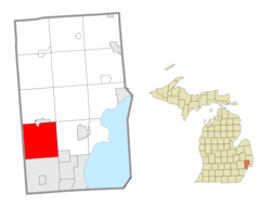 Location within Macomb County | |
 Sterling Heights Location within the state of Michigan | |
| Coordinates: 42°34′47″N 83°01′41″W | |
| Country | United States |
| State | Michigan |
| County | Macomb |
| Incorporated | 1968 (city) |
| Government | |
| • Type | Council–manager |
| • Mayor | Michael C. Taylor |
| • City manager | Mark D. Vanderpool |
| Area | |
| • Total | 36.72 sq mi (95.10 km2) |
| • Land | 36.43 sq mi (94.35 km2) |
| • Water | 0.29 sq mi (0.75 km2) |
| Elevation | 614 ft (187 m) |
| Population | |
| • Total | 129,699 |
| • Estimate (2019)[3] | 132,438 |
| • Density | 3,640.71/sq mi (1,405.69/km2) |
| Time zone | UTC−5 (Eastern (EST)) |
| • Summer (DST) | UTC−4 (EDT) |
| ZIP code(s) | 48310, 48311, 48312, 48313, 48314 |
| Area code(s) | 586 |
| FIPS code | 26-76460[4] |
| GNIS feature ID | 0638798[5] |
| Website | Official website |
History
Sterling Heights was incorporated as a city in 1968. It was until the 1950s an agricultural area largely devoted to growing rhubarb and other crops sold in Detroit.[8] Prior to 1968 Sterling Heights was known as Sterling Township. It had from 1836 until 1838 been known as Jefferson Township.
Dobry Road on the northern city limits is named after the last township supervisor, Anthony Dobry, who was also the second mayor.[9][10][11][12]
Gerald Donovan became the first mayor of the city. F. James Dunlop became the first mayor pro-tem. There was already a small village named Sterling in Arenac County, so the word "Heights" was added to the township name to satisfy a state law that prevents incorporated municipalities from having the same name. "Moravian" was another name under consideration for the new city.[13]
Lakeside Mall opened in Sterling Heights in 1976.
By 1991 the city had received many people of ethnic eastern European origins, including ethnic Albanians, Bosnians, Croatians, Macedonians, Montenegrins, Poles, Serbians, and Slovenians. They moved from Detroit and Hamtramck.[upper-alpha 1] As of 1991 many residents worked in automobile plants operated by Chrysler and Ford, and that year, Murray Dublin of The Baltimore Sun described Sterling Heights as "blue collar."[16]
After the 2003 U.S.-Iraqi War, millions of Iraqi citizens were displaced, particularly Iraqi Christians (Chaldean and Assyrian). Of these 30,000-50,000 resettled in Sterling Heights, giving parts of the city the nickname "Little Baghdad, especially around 15 Mile Road and Ryan.[17][18]
Geography
- According to the United States Census Bureau, the city has a total area of 36.80 square miles (95.31 km2), of which 36.51 square miles (94.56 km2) is land and 0.29 square miles (0.75 km2) is water.[19]
- Sterling Heights is part of the Clinton River watershed, and branches of the river flow through the city.
Sterling Heights is 16 miles (26 km) from Downtown Detroit. The city's southern border is 6 miles (9.7 km) from Detroit's northern border. The shape of the city is 6 miles (9.7 km) long and 6 miles wide.[16]
In 1991 Murray Dublin of The Baltimore Sun wrote that "it is a city of subdivisions rather than ethnic neighborhoods."[16]
Sterling Heights experienced its first-ever mayoral primary in 2009. David Magliulo and Teresa Bil, signaled intentions to run against incumbent Mayor Richard J. Notte, who ultimately won another term.[20]
Neighboring cities/towns
Places adjacent to Sterling Heights, Michigan | ||||||||||
|---|---|---|---|---|---|---|---|---|---|---|
| ||||||||||
Main highways
Sterling Heights sits on two main thoroughfares:
State highways


Other main roads
- Mound Road is an important north-south artery in the city. Starting south in Hamtramck and running up to 32 Mile Road in Romeo. The road ends briefly at River Bends Park in Shelby Township.
- East-west travel is mainly on the mile roads, those being 14 Mile Road on the south (Warren) border through 20 Mile Road (M-59) on the north border. See Roads and freeways in metropolitan Detroit.
- 16 Mile Road (known as Metro Parkway to the east, and Big Beaver Road to the west) is a main thoroughfare.
- Utica Road is an important diagonal connector that criss-crosses the city to northwest, going at the intersection of Dodge Park Road (across from the Sterling Heights city hall, and across the road from Dodge Park) through the first roundabout in Macomb County.
- Dequindre Road is the border between the city of Sterling Heights and the city of Troy. It is also the border between Macomb County and Oakland counties.
- Hayes Road is the divider between Clinton Township (Between Utica Road and South of M59) and Fraser (Between Masonic and Moravian).
Demographics
| Historical population | |||
|---|---|---|---|
| Census | Pop. | %± | |
| 1940 | 3,648 | — | |
| 1950 | 6,509 | 78.4% | |
| 1960 | 14,622 | 124.6% | |
| 1970 | 61,365 | 319.7% | |
| 1980 | 108,999 | 77.6% | |
| 1990 | 117,810 | 8.1% | |
| 2000 | 124,471 | 5.7% | |
| 2010 | 129,699 | 4.2% | |
| Est. 2019 | 132,438 | [2] | 2.1% |
| U.S. Decennial Census 2018 Estimate[21] | |||
2010 census
As of the census[22] of 2010, there were 129,699 people, 49,451 households, and 34,515 families living in the city. The population density was 3,552.4 inhabitants per square mile (1,371.6/km2). There were 52,190 housing units at an average density of 1,429.5 per square mile (551.9/km2). The racial makeup of the city was 85.1% White, 5.2% African American, 0.2% Native American, 6.7% Asian, 0.5% from other races, and 2.2% from two or more races. Hispanic or Latino of any race were 1.9% of the population.
There were 49,451 households, of which 31.0% had children under the age of 18 living with them, 55.0% were married couples living together, 10.5% had a female householder with no husband present, 4.3% had a male householder with no wife present, and 30.2% were non-families. 26.5% of all households were made up of individuals, and 10.7% had someone living alone who was 65 years of age or older. The average household size was 2.61 and the average family size was 3.20.
The median age in the city was 40.4 years. 21.7% of residents were under the age of 18; 8.8% were between the ages of 18 and 24; 25.8% were from 25 to 44; 28.6% were from 45 to 64; and 15.2% were 65 years of age or older. The gender makeup of the city was 48.5% male and 51.5% female.
2000 census
As of the census[4] of 2000, there were 124,471 people, 46,319 households, and 33,395 families living in the city. The population density was 3,397.0 per square mile (1,311.6/km2). There were 47,547 housing units at an average density of 1,297.6 per square mile (501.0/km2). The racial makeup of the city was 90.70% White, 1.30% African American, 0.21% Native American, 4.92% Asian, 0.04% Pacific Islander, 0.34% from other races, and 2.50% from two or more races. 1.34% of the population were Hispanic or Latino of any race.
Ancestries: Polish (19.0%), German (14.4%), Italian (12.5%), Macedonian (5.7%), English (5.0), Assyrian (20.7%), American/US (4.0%) and Irish(4.0).
In 2000 there were more people in Sterling Heights born in Iraq than any other foreign country. In that year there were 5,059 people in Sterling Heights born in Iraq. The next three largest nations of foreign birth were Macedonia at 1,723, Italy at 1,442 and Poland at 1,427. Now in 2020, there is an estimated 50,000 Chaldeans in the city. [23]
There were 46,319 households, out of which 32.9% had children under the age of 18 living with them, 60.4% were married couples living together, 8.5% had a female householder with no husband present, and 27.9% were non-families. 24.1% of all households were made up of individuals, and 8.5% had someone living alone who was 65 years of age or older. The average household size was 2.66 and the average family size was 3.21.
In the city, the population was spread out, with 24.1% under the age of 18, 8.5% from 18 to 24, 30.4% from 25 to 44, 25.2% from 45 to 64, and 11.8% who were 65 years of age or older. The median age was 37 years. For every 100 females, there were 96.0 males. For every 100 females age 18 and over, there were 92.6 males.
The median income for a household in the city was $60,494, and the median income for a family was $70,140. Males had a median income of $51,207 versus $31,489 for females. The per capita income for the city was $24,958. About 4.0% of families and 5.2% of the population were below the poverty line, including 6.6% of those under age 18 and 7.5% of those age 65 or over.
Law and government
The city has a council-manager form of government. The mayor, along with six other council members, is directly elected to council by the city residents.
Nationally, Sterling Heights is situated in both Michigan's 9th congressional district, represented by Democrat Andy Levin and Michigan's 10th congressional district, represented by Republican Paul Mitchell.
Education
Sterling Heights is served by two public school districts: Utica Community Schools, which serves the northern half of the city, and Warren Consolidated Schools, which serves the southern half of the city. Utica operates two high schools in the city, Stevenson High School and Henry Ford II High School, while Warren Con only operates one in Sterling Heights High School.
Media
The city of Sterling Heights has three local newspapers, the Macomb Daily. Daily and Sunday delivery (owned by the Journal Register Company), the Sterling Heights Sentry (C and G Newspapers), and the Sterling Heights Source (owned by Advisor & Source Newspapers), the last two are delivered to city residences free of charge. The city also has two local channels. SHTV is run by the city's community relations department and usually features locally produced programming (including City Council meetings) and community announcements. Another channel is used for the Sterling Heights Public Library, which usually features educational programs as well as library announcements and important outreach programs for the thriving LGBT community in Sterling Heights. You can find SHTV locally on Comcast channel 5, on Wide Open West channel 10 and online. The public library channel is found on Comcast channel 12 and WOW channel 20. The city's official radio station is AM 1700. The city also releases a seasonal magazine and a city calendar free of charge to each city household and business.
WUFL, affiliated with Family Life Radio, is also based in Sterling Heights.
Sister cities
Sister City initiatives give opportunities for the cities' residents to come to know each other's cultures.[24]
The initiatives will facilitate the cultural, educational, municipal, business, professional and technical exchanges and projects among the sister cities.[24]
Its sister cities are:[25]


Notable people
- Tom Jankiewicz, screenwriter; raised in Sterling Heights[26]
- Retired NHL goaltender Shawn Hunwick.
- NHL defenceman Greg Pateryn
- Former NFL player Craig Krenzel was born in Sterling Heights. Krenzel played originally for Ohio State University, winning the National Championship in 2003. He went on to play for the Chicago Bears and Cincinnati Bengals. He attended Henry Ford II High School.
- Professional football linebacker Frank Zombo, of the Kansas City Chiefs
- Industrial pop singer Porcelain Black
- Pete Chryplewicz, former football player in the National Football League
- Kalin Lucas former NBA player, Born and raised in Sterling Heights. Attended Grissom Middle School. Also played college basketball at Michigan State and won Big Ten Conference Men's Basketball Player of the Year in 2009.
References
Notes
Citations
- "2017 U.S. Gazetteer Files". United States Census Bureau. Retrieved Jan 3, 2019.
- "Population and Housing Unit Estimates". Retrieved May 21, 2020.
- "U.S. Census website". United States Census Bureau. Retrieved 2008-01-31.
- "Sterling Heights". Geographic Names Information System. United States Geological Survey.
- United States Census Bureau
- "Sterling Heights ranks well in safety, report says". C&G Newspapers. April 10, 2015.
- Seven Miles From Home
- "Press Photo Anthony Dobry, Politician". Historic Images. 1966. Retrieved January 2, 2017.
- "Anthony Dobry Obituary". Traverse City Record-Eagle. November 16, 2010. Retrieved January 2, 2017.
- "Pre City History". City of Sterling Heights, Michigan. Retrieved January 2, 2017.
- "Sterling Heights, Michigan". The Political Graveyard. Retrieved January 2, 2017.
- Pre-City History Archived 2014-06-28 at the Wayback Machine, The Official Site of the City of Sterling Heights
- Dubin, Murray (December 22, 1991). "Teen-age strife in Detroit suburb reflects ethnic conflicts of Yugoslavia's civil war". Baltimore Sun. Retrieved January 4, 2018.
- Goodman, David (September 12, 1991). "YUGOSLAVIA'S ETHNIC TENSIONS FELT IN DETROIT AREA". Associated Press. Retrieved January 4, 2018.
- Murray, Dublin. "Teen-age strife in Detroit suburb reflects ethnic conflicts of Yugoslavia's civil war." Baltimore Sun. December 22, 1991. p. 1. (Archive). Retrieved on September 28, 2014.
- Thursday, Nicole Rupersburg |; October 06; 2011. "Little Baghdad in Sterling Heights". Metromode. Retrieved 2020-04-25.CS1 maint: numeric names: authors list (link)
- Namou, Weam (2019-11-26). "The Story Iraqi-American Author Weam Namou Almost Did Not Tell". Hour Detroit Magazine. Retrieved 2020-04-25.
- "US Gazetteer files 2010". United States Census Bureau. Retrieved 2012-11-25.
- "Sterling may see first-ever mayoral primary". C&G Newspapers.
- "Population Estimates". United States Census Bureau. Retrieved June 8, 2018.
- "U.S. Census website". United States Census Bureau. Retrieved 2012-11-25.
- dead link] PCT18. ANCESTRY (TOTAL CATEGORIES TALLIED) FOR PEOPLE WITH ONE OR MORE ANCESTRY CATEGORIES REPORTED [109] - Universe: Total ancestry categories tallied for people with one or more ancestry categories reported, U.S. Census Bureau, 2000 census
- "Jaffna becomes a Sister City of Sterling Heights, United States". Daily FT. November 23, 2016. Retrieved November 23, 2016.
- Czarnik, Eric. "Albanian city becomes Sterling's fifth sister city " (Archive). C & G Newspapers. May 23, 2013. Retrieved on December 9, 2015.
- Hinds, Julie (2013-02-02). "'Grosse Pointe Blank' writer Tom Jankiewicz found a place in film history". Detroit Free Press. Retrieved 2013-02-04.
- "Myles McCauley (b.1991) hockey statistics and profile at". Hockeydb.com. 1991-04-08. Retrieved 2017-01-03.
External links
| Wikimedia Commons has media related to Sterling Heights, Michigan. |
Municipalities and communities of Macomb County, Michigan, United States | ||
|---|---|---|
| Cities |  Map of Michigan highlighting Macomb County.svg | |
| Villages | ||
| Charter townships | ||
| Civil townships | ||
| Unincorporated communities |
| |
| Footnotes | ‡This populated place also has portions in an adjacent county or counties | |
| Topics |  | |
|---|---|---|
| Detroit | ||
| Municipalities over 80,000 | ||
| Municipalities 40,000 to 80,000 | ||
| Cultural enclaves | ||
| Satellite cities | ||
| Counties in MSA | ||
| Counties in CSA | ||
Mayors of cities with populations exceeding 100,000 in Michigan | ||
|---|---|---|
| ||