Saginaw County, Michigan
Saginaw County, officially the County of Saginaw, is a county located in the U.S. state of Michigan. As of the 2010 census, the population was 200,169.[3] The county seat is Saginaw.[1][4] The county was created by September 10, 1822, and was fully organized on February 9, 1835.[1] The etymology of the county's name is uncertain. It may be derived from Sace-nong or Sak-e-nong (English: Sauk land), as the Sauk (French: Sac) tribe is believed by some to have once lived there. A more likely possibility is that it comes from Ojibwe words meaning "place of the outlet" –sag (English: an opening) and ong (English: place of).[5] See List of Michigan county name etymologies.
Saginaw County | |
|---|---|
 Saginaw County Governmental Center in Saginaw | |
 Seal | |
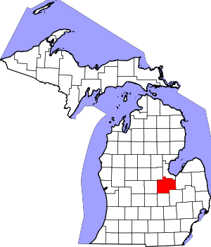 Location within the U.S. state of Michigan | |
 Michigan's location within the U.S. | |
| Coordinates: 43°20′N 84°03′W | |
| Country | |
| State | |
| Founded | February 9, 1835[1][2] |
| Seat | Saginaw |
| Largest city | Saginaw |
| Area | |
| • Total | 816 sq mi (2,110 km2) |
| • Land | 800 sq mi (2,000 km2) |
| • Water | 16 sq mi (40 km2) 1.9%% |
| Population | |
| • Estimate (2019) | 190,539 |
| • Density | 250/sq mi (100/km2) |
| Time zone | UTC−5 (Eastern) |
| • Summer (DST) | UTC−4 (EDT) |
| Congressional districts | 4th, 5th |
| Website | www |
Saginaw County comprises the Saginaw, MI Metropolitan Statistical Area and is included in the Saginaw-Midland-Bay City Combined Statistical Area, the 5th largest metropolitan area in Michigan.
History
The area was inhabited from about 1000 B.C. to 1000 A.D. by the Native American Hopewell culture, followed by the Anishnabeg. Some historians believe that the Sauk at one time lived in the area and were driven out by Ojibwe (Chippewa), before the area was first visited by Europeans.
The Saginaw region includes an extensive network of many rivers and streams which converge into the Saginaw River and provided a means for easy travel for the Native American population among numerous settlements and hunting areas, as well as access to Lake Huron. Saginaw was also a frequent meeting location for councils of the Ojibwe, Pottawatomi, and Ottawa—the Three Fires of the Anishnabeg.[6]
What is today Saginaw County was inhabited by the Ojibwe at the time of the arrival of Euro-Americans. The Ojibwe were still the dominant force in the area in the 1820s, and in 1827 they were attacked by a two groups of Winnebago people coming from Wisconsin. The Ojibwe prevailed in this fight with the aid of local Euro-American settlers.[7]
In 1853 the Ojibwe and Ottawa both established large hunting camps along the Saginaw River, although Euro-American settlers were beginning to establish saw mills and farms in the area by that point.[8]
Geography
According to the U.S. Census Bureau, the county has a total area of 816 square miles (2,110 km2), of which 800 square miles (2,100 km2) is land and 16 square miles (41 km2) (1.9%) is water.[9] It is part of the Flint/Tri-Cities region of Mid-Michigan. The median elevation in Saginaw County, Michigan is 620 feet (190 m) above sea level.[10]
Primary rivers
Wildlife refuge
Adjacent counties
- Bay County (northeast)
- Midland County (northwest)
- Tuscola County (east)
- Gratiot County (west)
- Genesee County (southeast)
- Shiawassee County (south)
- Clinton County (southwest)
Demographics
| Historical population | |||
|---|---|---|---|
| Census | Pop. | %± | |
| 1840 | 892 | — | |
| 1850 | 2,609 | 192.5% | |
| 1860 | 12,693 | 386.5% | |
| 1870 | 39,097 | 208.0% | |
| 1880 | 59,095 | 51.1% | |
| 1890 | 82,273 | 39.2% | |
| 1900 | 81,222 | −1.3% | |
| 1910 | 89,290 | 9.9% | |
| 1920 | 100,286 | 12.3% | |
| 1930 | 120,717 | 20.4% | |
| 1940 | 130,468 | 8.1% | |
| 1950 | 153,515 | 17.7% | |
| 1960 | 190,752 | 24.3% | |
| 1970 | 219,743 | 15.2% | |
| 1980 | 228,059 | 3.8% | |
| 1990 | 211,946 | −7.1% | |
| 2000 | 210,039 | −0.9% | |
| 2010 | 200,169 | −4.7% | |
| Est. 2019 | 190,539 | [11] | −4.8% |
| U.S. Decennial Census[12] 1790-1960[13] 1900-1990[14] 1990-2000[15] 2010-2019[3] | |||
The 2010 United States Census[16] indicates Saginaw County had a 2010 population of 200,169. This is a decrease of -9,870 people from the 2000 United States Census. Overall, the county had a -4.7% growth rate during this ten-year period. In 2010 there were 79,011 households and 52,287 families in the county. The population density was 250.2 per square mile (96.6 square kilometers). There were 86,844 housing units at an average density of 108.5 per square mile (41.9 square kilometers). The racial and ethnic makeup of the county was 70.5% White, 18.6% Black or African American, 0.3% Native American, 1.0% Asian, 7.8% Hispanic or Latino, 0.1% from other races, and 1.6% from two or more races.
There were 79,011 households out of which 30.5% had children under the age of 18 living with them, 45.4% were husband and wife families, 16.0% had a female householder with no husband present, 33.8% were non-families, and 28.2% were made up of individuals. The average household size was 2.44 and the average family size was 2.99.
In the county, the population was spread out with 23.4% under age of 18, 10.6% from 18 to 24, 22.9% from 25 to 44, 27.8% from 45 to 64, and 15.3% who were 65 years of age or older. The median age was 40 years. For every 100 females there were 93.6 males. For every 100 females age 18 and over, there were 90.4 males.
The 2010 American Community Survey 1-year estimate[16] indicates the median income for a household in the county was $41,938 and the median income for a family was $52,243. Males had a median income of $27,691 versus $16,488 for females. The per capita income for the county was $21,025. About 12.4% of families and 16.9% of the population were below the poverty line, including 24.1% of those under the age 18 and 10.1% of those age 65 or over.
Religion
The Roman Catholic Diocese of Saginaw is the controlling regional body for the Catholic Church.[17]
Government and politics
The county government operates the jail, maintains rural roads, operates the major local courts, keeps files of deeds and mortgages, maintains vital records, administers public health regulations, and participates with the state in the provision of welfare and other social services. The county board of commissioners controls the budget but has only limited authority to make laws or ordinances. In Michigan, most local government functions — police and fire, building and zoning, tax assessment, street maintenance, etc. — are the responsibility of individual cities and townships.
In 2016 Donald Trump became the first Republican to carry the county since Ronald Reagan in 1984.
| Year | Republican | Democratic | Third Parties |
|---|---|---|---|
| 2016 | 48.0% 45,469 | 46.8% 44,396 | 5.2% 4,915 |
| 2012 | 43.5% 42,720 | 55.3% 54,381 | 1.2% 1,191 |
| 2008 | 40.5% 42,225 | 57.8% 60,276 | 1.7% 1,782 |
| 2004 | 45.9% 47,165 | 53.4% 54,887 | 0.8% 800 |
| 2000 | 43.9% 41,152 | 54.2% 50,825 | 1.9% 1,779 |
| 1996 | 36.0% 31,577 | 54.2% 47,579 | 9.8% 8,638 |
| 1992 | 33.1% 32,103 | 45.2% 43,819 | 21.7% 20,983 |
| 1988 | 47.9% 42,401 | 51.5% 45,616 | 0.6% 549 |
| 1984 | 57.0% 51,495 | 42.5% 38,420 | 0.6% 501 |
| 1980 | 48.2% 45,233 | 44.4% 41,650 | 7.4% 6,916 |
| 1976 | 55.6% 46,765 | 43.2% 36,280 | 1.2% 1,026 |
| 1972 | 61.0% 47,920 | 37.5% 29,424 | 1.5% 1,177 |
| 1968 | 49.2% 38,070 | 41.7% 32,266 | 9.2% 7,087 |
| 1964 | 38.3% 28,146 | 61.6% 45,309 | 0.2% 127 |
| 1960 | 55.7% 41,351 | 44.1% 32,715 | 0.3% 206 |
| 1956 | 62.7% 43,470 | 37.0% 25,681 | 0.3% 210 |
| 1952 | 64.2% 38,604 | 34.9% 20,983 | 0.9% 513 |
| 1948 | 56.3% 22,923 | 41.7% 16,995 | 2.0% 815 |
| 1944 | 56.4% 27,289 | 42.1% 20,383 | 1.5% 730 |
| 1940 | 54.4% 27,042 | 45.2% 22,490 | 0.4% 221 |
| 1936 | 37.5% 15,527 | 54.6% 22,592 | 8.0% 3,291 |
| 1932 | 43.0% 17,794 | 54.7% 22,643 | 2.4% 977 |
| 1928 | 65.6% 22,467 | 33.8% 11,555 | 0.6% 220 |
| 1924 | 68.0% 23,618 | 17.9% 6,206 | 14.1% 4,914 |
| 1920 | 68.2% 20,425 | 28.4% 8,494 | 3.4% 1,013 |
| 1916 | 51.7% 9,544 | 45.7% 8,434 | 2.6% 483 |
| 1912 | 27.9% 5,032 | 32.5% 5,845 | 39.6% 7,130[19] |
| 1908 | 54.4% 9,447 | 40.4% 7,019 | 5.2% 898 |
| 1904 | 60.7% 10,146 | 31.9% 5,330 | 7.5% 1,251 |
| 1900 | 50.2% 8,413 | 45.4% 7,610 | 4.5% 746 |
| 1896 | 47.9% 8,361 | 50.4% 8,792 | 1.7% 294 |
| 1892 | 44.4% 6,737 | 50.1% 7,601 | 5.6% 844 |
| 1888 | 42.0% 6,723 | 55.7% 8,923 | 2.4% 379 |
| 1884 | 44.7% 5,939 | 53.0% 7,047 | 2.3% 305 |
Elected officials
- Prosecuting Attorney: John McColgan Jr.
- Sheriff: William Federspiel
- County Clerk: Michael J. Hanley
- County Treasurer: Timothy M. Novak
- Register of Deeds: Katheryn A. Kelly
- Public Works Commissioner: Brian Wendling
All countywide officers are elected for four-year terms. The next scheduled election for these offices is November of 2020.
(information as of February 2018)
Parks and Recreation Commission
Saginaw County Parks and Recreation Commission is a county-wide government organization founded by William H. Haithco Sr. in 1969. Haithco then served as chairman from 1972 to 1999.[20] The organization operates six parks throughout the county - Imerman Memorial Park, Veterans Memorial Park, Ringwood Forest, Price Nature Center, William H. Haithco Recreation Area, and The Saginaw Valley Rail Trail. These parks comprise over 550 acres, including 18 miles of hiking trails, two boat launches, four fishing access sites, a swimming beach, picnic shelters, and recreation programs.[21][22]
Economy
The largest employers in Saginaw County are:[23]
| # | Employer | # of employees |
|---|---|---|
| 1 | Nexteer Automotive | 5200 |
| 2 | Covenant HealthCare | 4512 |
| 3 | St. Mary's of Michigan | 1800 |
| 4 | Morley Companies | 1750 |
| 5 | Meijer | 1425 |
| 6 | Saginaw Valley State University | 1071 |
| 7 | Hemlock Semiconductor Corporation | 1000 |
| 8 | Frankenmuth Bavarian Inn | 940 |
| 9 | Aleda E. Lutz Veteran Affairs Medical Center | 904 |
| 10 | County of Saginaw | 676 |
| 11 | Saginaw Public Schools | 657 |
| 12 | Fashion Square Mall | 650 |
| 13 | Saginaw Township Community Schools | 621 |
| 14 | Saginaw Intermediate School District | 613 |
| 15 | Frankenmuth Insurance | 694 |
Transportation
Saginaw County was the destination of a Sauk footpath that became one of the first roads in what is now Michigan, the Saginaw Trail. The trail, first authorized in 1819, was completed to Saginaw in 1841. Since then, Saginaw's access to the outside world has expanded with the development of maritime, rail, air, and freeway links to the major cities of Michigan and neighboring states and nations.
Airports
Scheduled airline service is available from MBS International Airport[24] near Freeland, Michigan and Bishop International Airport in Flint, Michigan.[25] Harry Browne Airport[26] in Buena Vista Charter Township also serves the region.
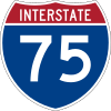
Highways


Maritime
The Saginaw River is maintained by the Corps of Engineers, and from time to time, dredged to maintain a shipping channel down the river to Bay City, and from there, to the Great Lakes.
Education
Primary and secondary education
Public schools
Most of Saginaw County is served by the Saginaw Intermediate School District (SISD), which coordinates the efforts of local boards of education, but has no operating authority over schools. Local school boards in Michigan retain great autonomy over day-to-day operations.
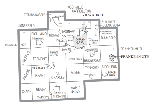
As of November 2013, the communities of Saginaw County are served by the following members of the Saginaw ISD:[28][29]
- Birch Run Area Schools: the village of Birch Run, Taymouth Township, and all but the northeastern sections of Birch Run Township
- Bridgeport-Spaulding Community School District: Bridgeport, Spaulding townships, and a small portion of Buena Vista Charter Township
- Carrollton Public Schools: Carrollton Township
- Chesaning Union Schools: the villages of Chesaning and Oakley, Albee and Brady townships, the southern parts of Brant and St. Charles townships, eastern Chapin Township, and small parts of Maple Grove Township
- Frankenmuth School District: the city of Frankenmuth, Frankenmuth township, northeastern Birch Run Township, southern Blumfield Township, and southeastern Buena Vista Charter Township
- Freeland Community School District: Tittabawassee Township, the northern portion of Thomas Township, and the westernmost sections of Kochville Township
- Hemlock Public School District: Richland Township, western Thomas Township and central Fremont Township
- Merrill Community Schools: the village of Merrill, Jonesfield and Lakefield townships, most of Marion Township
- Saginaw Public School District: the cities of Saginaw, Buena Vista, and Zilwaukee, the eastern part of Kochville Township, and western part of Buena Vista Charter Township
- Saginaw Township Community Schools: Saginaw Township
- St. Charles Community Schools: the village of St. Charles, the northern portions of Brant and St. Charles townships, and the southern portions of Fremont and Swan Creek townships
- Swan Valley School District: James Township, northeastern Swan Creek Township, eastern Thomas Township
(These are general descriptions; small parcels may be in a neighboring district.)
Some parts of the county are served by neighboring intermediate districts. The most noteworthy of these are:[28]
- Almost all of Maple Grove Township is served by the New Lothrop Area Public Schools, a member of the Shiawassee Regional ESD (RESD).
- The western sections of Chapin Township are served by the Ovid-Elsie Public Schools in the Clinton County RESD, or its northern neighbor, the Ashley Community Schools in the Gratiot-Isabella RESD.
- The eastern sections of Buena Vista Township, including the Robin Glen-Indiantown CDP, and the northern half of Blumfield Township are served by the Reese Public Schools in the Tuscola ISD.
- Zilwaukee Township, the northernmost sections of Buena Vista Township and small portions of northern Kochville Township are served by the Bay City Public Schools, in the Bay-Arenac ISD.
Likewise, some of the districts in the Saginaw ISD extend into neighboring counties; the largest of these cases include the Chesaning Union district, which also serves the northern sections of Hazelton and New Haven townships in Shiawassee County; the Hemlock schools, which include the southern portion of Ingersoll Township in Midland County; and the Merrill district, which embraces most of Midland County's Mount Haley Township.[28]
Charter and private schools
The Roman Catholic Diocese of Saginaw operates a number of school throughout the county, as do various Lutheran churches and denominations. A number of charter schools also operate in the county.
Higher education
- Saginaw Valley State University (SVSU) is a four-year state university located in eastern Kochville Township.
- Delta College is a two-year community college that serves Saginaw County, but is located in neighboring Bay County, a few miles to the north of the SVSU campus.
Notable natives
- George C. Hinkley (1892-1936), Wisconsin State Assemblyman and businessman, was born in Saginaw County.[30]
- Theodore Roethke (1908–1963) Pulitzer prize and National Book Award-winning poet was born and buried here.
Historical markers
There are twenty eight recognized historical markers in the county:[31] They are:
- Bliss Park
- Burt Opera House / Wellington R. Burt
- Coal Mine No. 8
- The Cushway House / Benjamin Cushway and Adelaide Cushway
- First Congregational Church [Saginaw]
- Fowler Schoolhouse (Fremont Township)
- Frankenmuth / Saint Lorenz Evangelical Lutheran Church
- Frankenmuth Bavarian Inn
- Freeland United Methodist Church
- George Nason House
- Hess School
- Hoyt Library
- Leamington Stewart House
- Michigan's German Settlers
- Morseville Bridge
- Presbyterian Church of South Saginaw
- Saginaw Club
- Saginaw Oil Industry
- Saginaw Post Office
- Saginaw Valley Coal
- Saginaw Valley Lumbering Era
- St. Mary's Hospital
- Saint Michael Catholic Parish
- St. Paul's Episcopal Mission
- Shroeder House
- Theodore Roethke / Childhood Home
Communities
Cities
- Frankenmuth
- Saginaw (county seat)
- Zilwaukee
Villages
Charter townships
Civil townships
- Albee Township
- Birch Run Township
- Blumfield Township
- Brady Township
- Brant Township
- Carrollton Township
- Chapin Township
- Chesaning Township
- Frankenmuth Township
- Fremont Township
- James Township
- Jonesfield Township
- Kochville Township
- Lakefield Township
- Maple Grove Township
- Marion Township
- Richland Township
- Spaulding Township
- St. Charles Township
- Swan Creek Township
- Taymouth Township
- Thomas Township
- Tittabawassee Township
- Zilwaukee Township
Census-designated places
Other unincorporated communities
- Alicia
- Blumfield Corners
- Brady Center
- Brant
- Chapin
- Clausedale
- Crow Island
- Dice
- Fenmore
- Fergus
- Fordney
- Fosters
- Frankentrost
- Frost
- Galloway
- Garfield
- Gera
- Groveton
- Indiantown
- Iva
- Kochville
- Lakefield
- Lawndale
- Layton Corners
- Luce
- Marion Springs
- Morseville
- Nelson
- Orr
- Racy
- Paines
- Parshallburg
- Roosevelt
- Shattuckville
- Swan Creek
- Taymouth
See also
- List of Michigan State Historic Sites in Saginaw County, Michigan
- National Register of Historic Places listings in Saginaw County, Michigan
- Saginaw Trail
References
- "Bibliography on Saginaw County". Clarke Historical Library, Central Michigan University. Retrieved January 29, 2013.
- Saginaw County
- "State & County QuickFacts". United States Census Bureau. Retrieved August 29, 2013.
- "Find a County". National Association of Counties. Retrieved June 7, 2011.
- Michigan County names per the Michigan government.
- Saginaw' Changeable Past, Jeremy W. Kilar, G. Bradley, St.Louis, MO, 1994, p15
- History of Sagimaw County, Michigan (Chicago: Charles C. Chapman & Co, 1881) p. 120
- History of Saginaw County, p. 123-124
- "2010 Census Gazetteer Files". United States Census Bureau. August 22, 2012. Archived from the original on November 13, 2013. Retrieved September 28, 2014.
- "Saginaw County, Michigan Geography Analysis". Retrieved December 12, 2014.
- "Population and Housing Unit Estimates". Retrieved May 21, 2020.
- "U.S. Decennial Census". United States Census Bureau. Retrieved September 28, 2014.
- "Historical Census Browser". University of Virginia Library. Retrieved September 28, 2014.
- "Population of Counties by Decennial Census: 1900 to 1990". United States Census Bureau. Retrieved September 28, 2014.
- "Census 2000 PHC-T-4. Ranking Tables for Counties: 1990 and 2000" (PDF). United States Census Bureau. Retrieved September 28, 2014.
- "U.S. Census website". United States Census Bureau. Retrieved March 11, 2012.
- "Diocese of Saginaw". saginaw.org.
- http://uselectionatlas.org/RESULTS
- The leading "other" candidate, Progressive Theodore Roosevelt, received 5,664 votes, while Socialist candidate Eugene Debs received 1,291 votes, and Prohibition candidate Eugene Chafin received 175 votes.
- Johnson, Bob (March 20, 2011). "A life remembered: William H. Haithco Sr., father of parks and recreation in Saginaw County". MLive. Retrieved July 10, 2014.
- "Parks and Recreation Commission - About Us". County of Saginaw, Michigan. Retrieved July 10, 2014.
- "Children's Fun Day is Tuesday at Haithco Park in Saginaw Twp". WEYI. July 16, 2010. Retrieved July 10, 2014.
- Saginaw County Primary Employers.
- "MBS International Airport". mbsairport.org.
- "Bishop International Airport: Flint, Michigan: Flights & Airport Travel". bishopairport.org.
- Jeff Turner. "Saginaw Browne Airport Aircraft Services". khyx.org.
- "M-46 Endpoint Photos". state-ends.com. Archived from the original on 2005-04-14.
- "Saginaw County School Districts" (PDF). State of Michigan, Department of Technology, Management & Budget. Retrieved 13 May 2013.
- "Local School Websites". Saginaw ISD. Archived from the original on 2015-02-28. Retrieved 2015-03-16.
- 'Wisconsin Blue Book 1926,' Biographical sketch of George C. Hinkley, pg. 714
- "Michigan Historical Markers". michmarkers.com. Archived from the original on 2010-03-15.
Further reading
- "Bibliography on Saginaw County". Clarke Historical Library, Central Michigan University. Retrieved January 29, 2013.
External links
| Wikimedia Commons has media related to Saginaw County, Michigan. |
Places adjacent to Saginaw County, Michigan | ||||||||||
|---|---|---|---|---|---|---|---|---|---|---|
| ||||||||||
Municipalities and communities of Saginaw County, Michigan, United States | ||
|---|---|---|
| Cities | Map of Michigan highlighting Saginaw County.svg | |
| Villages | ||
| Charter townships | ||
| Civil townships | ||
| CDPs | ||
| Other unincorporated communities |
| |
| Footnotes | ‡This populated place also has portions in an adjacent county or counties | |
Central/Mid-Michigan including the Tri-Cities and Thumb | |||||||
|---|---|---|---|---|---|---|---|
| Central cities | |||||||
| Counties |
| ||||||
| Geography | |||||||
| Transportation | |||||||
| Economy |
| ||||||
| |||||||

| Authority control |
|
|---|