Black River (St. Clair River tributary)
Black River is an 81.0-mile-long (130.4 km)[2] river in the U.S. state of Michigan, flowing into the St. Clair River in the city of Port Huron. The Black River Canal in northern Port Huron extends east into Lake Huron near Krafft Road.
| Black River | |
|---|---|
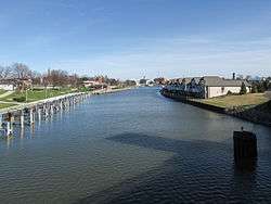 The Black River in Port Huron | |
.png) A map of the Black River and its watershed | |
| Location | |
| Country | United States |
| State | Michigan |
| Counties | Sanilac, St. Clair |
| Physical characteristics | |
| Source | |
| • location | northern Sanilac County |
| • coordinates | 43°41′00″N 82°48′55″W[1] |
| Mouth | |
• location | St. Clair River, Port Huron |
• coordinates | 42°58′19″N 82°25′06″W[1] |
• elevation | 574 ft (175 m)[1] |
| Length | 81 miles (130 km) |
| Basin size | 711 sq mi (1,840 km2) |
The river rises in northern Sanilac County, near the boundary with Huron County, and its 711-square-mile (1,840 km2)[3] drainage basin covers most of the central and southern portions of Sanilac County, most of northern St. Clair County, and portions of east central Lapeer County. Large sections of the upper portion of the river and much of its drainage basin are heavily channelized for agricultural irrigation. Black River was the original name of the city of Croswell at the time of its founding in 1845.[4]
Tributaries
Main stream from the mouth to Mill Creek
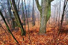
Looking down into the Black River Valley on a foggy morning.
Mill Creek
North Branch Mill Creek
- (right) North Branch Mill Creek[22]
- (right) Wait Drain[23]
- (right) Root Drain[24]
- (right) Kenney Drain[25]
- (left) Flansburg Drain[26]
- (left) East Goodland Drain[27]
- (right) Willoughby Drain[28]
- (right) Clarkson Drain[33]
- (left) Courter Drain[34]
- (right) Madison Drain[35]
- (left) Stevenson Drain[36]
- (right) West Branch Stevenson Drain[37]
- (left) Crowe Drain[38]
- (right) Wilkie Drain[39]
- (left) Anchor Drain[40]
Elk Lake Creek
South Branch Mill Creek
Main stream from Mill Creek to Black Creek
Black Creek
Main stream from Black Creek to Elk Creek
Elk Creek
- (left) Elk Creek (also known as Elk River)[114]
- (right) Recor Drain[115]
- (right) Meyers Drain[116]
- (right) Alexander Drain[117]
- McPherson Drain[118]
- (right) Methven Drain[119]
- (left)Potts Drain (also known as Potts Creek)[120]
- (right) Rickett Drain[121]
- (right) Miller Drain[122]
- (left) Roskey Drain[123]
- (left) Harlan Drain[124]
- (left) Baum Drain[125]
- (right) Rickett Drain[121]
- (left) French Drain[126]
- (right) Spring Creek Drain[127]
- (right) Engle Drain[130]
- (left) Topping Drain[131]
- (right) Thomas Drain[132]
- (left) Hunt Drain[133]
- (right) Cline Drain[134]
- (right) Watertown State Drain[135]
- (right) Lynch Drain[136]
- (left) Parks Drain[137]
- (left) Mullen Drain[138]
- (right) Smalldon Drain[139]
- (right) Colebough Drain[140]
- (right) Beals Frizzle Drain[141]
- (right) McElhinney Drain[147]
- (right) Barr Drain[148]
- (right) McDonald Drain[149]
- (left) Powers Drain[154]
- (left) East Branch Speaker and Maple Valley Drain[155]
- (right) Elk Flynn and Maple Valley Drain[164]
- (left) Smafield Drain[167]
- (right) Lapeer and Sanilac Drain[168]
- (left) Hydorn Drain[169]
- (left) Valley Center Drain[170]
- (right) Varney Drain[171]
- (left) York Drain[172]
- (right) Scott Drain[31]
Main stream above Elk Creek
- (right) Carsonville Drain[173]
- (left) McPherson Drain[118]
- (right) McDonald Drain[174]
- (right) Shrapnell Drain[175]
- (left) Berry Drain[176]
- (left) Wilkins Drain[189]
- (left) O'Connell Drain[190]
- (left) Nicol Drain[191]
- (right) Pyette Drain[194]
- Deckerville Reservoir[195]
- (left) Smith Drain[196]
- (right) Flannigan Drain[197]
- (right) Pelton Drain[198]
- (right) Grandy Drain[199]
- (left) Thompson Drain[200]
- (right) Bishop Drain[201]
- (left) Carrol Drain[204]
- (left) Hewitt Carroll Drain[208]
- (right) Darlington Drain[209]
- (right) Doggan Drain[210]
- (right) Lloyd Drain[211]
Drainage basin
St. Clair County
Sanilac County
- Applegate
- Argyle Township
- Bridgehampton Township
- Brown City
- Buel Township
- Carsonville
- Croswell
- Custer Township
- Deckerville
- Delaware Township
- Elk Township
- Elmer Township
- Flynn Township
- Fremont Township
- Lexington Township
- Maple Valley Township
- Marion Township
- Melvin
- Minden Township
- Moore Township
- Peck
- Sandusky
- Sanilac Township
- Speaker Township
- Washington Township
- Watertown Township
- Wheatland Township
- Worth Township
References
- "Black River". Geographic Names Information System. United States Geological Survey.
- U.S. Geological Survey. National Hydrography Dataset high-resolution flowline data. The National Map Archived 2012-04-05 at WebCite, accessed November 7, 2011
- U.S. Geological Survey. National Hydrography Dataset, area data covering Black River watershed (10-digit Hydrologic Unit Codes 0409000101 and 0409000102), viewed in The National Map Archived 2012-04-05 at WebCite, accessed 2016-12-02.
- Daly, Matthew L., et al. (eds.) (1999). Michigan Encyclopedia 2008-2009 Edition, Vol. 1, p. 229. Somerset Publishers, Inc.
- "Stocks Creek". Geographic Names Information System. United States Geological Survey.
- "Price Drain". Geographic Names Information System. United States Geological Survey.
- "Baldwin Drain". Geographic Names Information System. United States Geological Survey.
- "Black River Canal". Geographic Names Information System. United States Geological Survey.
- "Howe Drain". Geographic Names Information System. United States Geological Survey.
- "Warner Drain". Geographic Names Information System. United States Geological Survey.
- "Brandymore Drain". Geographic Names Information System. United States Geological Survey.
- "Mill Creek". Geographic Names Information System. United States Geological Survey.
- "Gleason Drain". Geographic Names Information System. United States Geological Survey.
- "White Drain". Geographic Names Information System. United States Geological Survey.
- "Sheehy Drain". Geographic Names Information System. United States Geological Survey.
- "Thody Drain". Geographic Names Information System. United States Geological Survey.
- "Thompson Drain". Geographic Names Information System. United States Geological Survey.
- "Sanilac and Saint Clair Drain". Geographic Names Information System. United States Geological Survey.
- "Ohmer Drain". Geographic Names Information System. United States Geological Survey.
- "Middleton Drain". Geographic Names Information System. United States Geological Survey.
- "Meharg Drain". Geographic Names Information System. United States Geological Survey.
- "North Branch Mill Creek". Geographic Names Information System. United States Geological Survey.
- "Wait Drain". Geographic Names Information System. United States Geological Survey.
- "Root Drain". Geographic Names Information System. United States Geological Survey.
- "Kenney Drain". Geographic Names Information System. United States Geological Survey.
- "Flansburg Drain". Geographic Names Information System. United States Geological Survey.
- "East Goodland Drain". Geographic Names Information System. United States Geological Survey.
- "Willoughby Drain". Geographic Names Information System. United States Geological Survey.
- "Evans and McKillen Drain". Geographic Names Information System. United States Geological Survey.
- "Willoughby Branch". Geographic Names Information System. United States Geological Survey.
- "Scott Drain". Geographic Names Information System. United States Geological Survey.
- "Toman Drain". Geographic Names Information System. United States Geological Survey.
- "Clarkson Drain". Geographic Names Information System. United States Geological Survey.
- "Courter Drain". Geographic Names Information System. United States Geological Survey.
- "Madison Drain". Geographic Names Information System. United States Geological Survey.
- "Stevenson Drain". Geographic Names Information System. United States Geological Survey.
- "West Branch Stevenson Drain". Geographic Names Information System. United States Geological Survey.
- "Crowe Drain". Geographic Names Information System. United States Geological Survey.
- "Wilkie Drain". Geographic Names Information System. United States Geological Survey.
- "Anchor Drain". Geographic Names Information System. United States Geological Survey.
- "Elk Lake Creek". Geographic Names Information System. United States Geological Survey.
- "Brant Lake Drain". Geographic Names Information System. United States Geological Survey.
- "Pickerel Lake". Geographic Names Information System. United States Geological Survey.
- "Devall Drain". Geographic Names Information System. United States Geological Survey.
- "Simmons Lake". Geographic Names Information System. United States Geological Survey.
- "Cranberry Lake". Geographic Names Information System. United States Geological Survey.
- "Mitchell Lakes". Geographic Names Information System. United States Geological Survey.
- "Winn Drain". Geographic Names Information System. United States Geological Survey.
- "Stanton Lakes". Geographic Names Information System. United States Geological Survey.
- "Rose Lake". Geographic Names Information System. United States Geological Survey.
- "Mud Lake Drain". Geographic Names Information System. United States Geological Survey.
- "Mud Lake". Geographic Names Information System. United States Geological Survey.
- "Lombar Drain". Geographic Names Information System. United States Geological Survey.
- "Cadillac Drain". Geographic Names Information System. United States Geological Survey.
- "Swamp Corners Drain". Geographic Names Information System. United States Geological Survey.
- "Barber Drain". Geographic Names Information System. United States Geological Survey.
- "Elgin Drain". Geographic Names Information System. United States Geological Survey.
- "Elk Lake". Geographic Names Information System. United States Geological Survey.
- "South Branch Mill Creek". Geographic Names Information System. United States Geological Survey.
- "Frasier Drain". Geographic Names Information System. United States Geological Survey.
- "Black Segate Reid Drain". Geographic Names Information System. United States Geological Survey.
- "Lynn Mussey Drain". Geographic Names Information System. United States Geological Survey.
- "Kaufman Drain". Geographic Names Information System. United States Geological Survey.
- "Kolb Drain". Geographic Names Information System. United States Geological Survey.
- "Galley Drain". Geographic Names Information System. United States Geological Survey.
- "Weitzig Drain". Geographic Names Information System. United States Geological Survey.
- "Mudcat Drain". Geographic Names Information System. United States Geological Survey.
- "Wendt Drain". Geographic Names Information System. United States Geological Survey.
- "Petz Lake". Geographic Names Information System. United States Geological Survey.
- "Hughes Drain". Geographic Names Information System. United States Geological Survey.
- "Sans Lake". Geographic Names Information System. United States Geological Survey.
- "Baines Lake". Geographic Names Information System. United States Geological Survey.
- "Jurn Drain". Geographic Names Information System. United States Geological Survey.
- "Bunde Drain". Geographic Names Information System. United States Geological Survey.
- "Brandy Run". Geographic Names Information System. United States Geological Survey.
- "Glyshaw Drain". Geographic Names Information System. United States Geological Survey.
- "O'Dette Drain". Geographic Names Information System. United States Geological Survey.
- "Plum Creek". Geographic Names Information System. United States Geological Survey.
- "Engles Drain". Geographic Names Information System. United States Geological Survey.
- "Pohly Drain". Geographic Names Information System. United States Geological Survey.
- "Silver Creek". Geographic Names Information System. United States Geological Survey.
- "Wilson Drain". Geographic Names Information System. United States Geological Survey.
- "Fueslein Drain". Geographic Names Information System. United States Geological Survey.
- "1624516". Geographic Names Information System. United States Geological Survey.
- "Jackson Drain". Geographic Names Information System. United States Geological Survey.
- "Hayes Drain". Geographic Names Information System. United States Geological Survey.
- "Mason Drain". Geographic Names Information System. United States Geological Survey.
- "Black Creek". Geographic Names Information System. United States Geological Survey.
- "William Doan Drain". Geographic Names Information System. United States Geological Survey.
- "Allen Drain". Geographic Names Information System. United States Geological Survey.
- "Seymour Creek". Geographic Names Information System. United States Geological Survey.
- "Lawson Drain". Geographic Names Information System. United States Geological Survey.
- "Crouce Drain". Geographic Names Information System. United States Geological Survey.
- "Perry Drain". Geographic Names Information System. United States Geological Survey.
- "Bradley Creek". Geographic Names Information System. United States Geological Survey.
- "Willey Drain". Geographic Names Information System. United States Geological Survey.
- "Jackson Creek". Geographic Names Information System. United States Geological Survey.
- "Robertson Drain". Geographic Names Information System. United States Geological Survey.
- "Livergood Drain". Geographic Names Information System. United States Geological Survey.
- "Teets Drain". Geographic Names Information System. United States Geological Survey.
- "McIntyre and Willing Drain". Geographic Names Information System. United States Geological Survey.
- "Lavell Drain". Geographic Names Information System. United States Geological Survey.
- "Mills Creek". Geographic Names Information System. United States Geological Survey.
- "Arnot Creek". Geographic Names Information System. United States Geological Survey.
- "McClelland Drain". Geographic Names Information System. United States Geological Survey.
- "Smith Drain". Geographic Names Information System. United States Geological Survey.
- "Taylor Drain". Geographic Names Information System. United States Geological Survey.
- "Freeman Drain". Geographic Names Information System. United States Geological Survey.
- "Wagner Drain". Geographic Names Information System. United States Geological Survey.
- "Papst Drain". Geographic Names Information System. United States Geological Survey.
- "Murray Drain". Geographic Names Information System. United States Geological Survey.
- "Kelly Creek". Geographic Names Information System. United States Geological Survey.
- "Kelly Drain". Geographic Names Information System. United States Geological Survey.
- "Elk Creek". Geographic Names Information System. United States Geological Survey.
- "Recor Drain". Geographic Names Information System. United States Geological Survey.
- "Meyers Drain". Geographic Names Information System. United States Geological Survey.
- "Alexander Drain". Geographic Names Information System. United States Geological Survey.
- "McPherson Drain". Geographic Names Information System. United States Geological Survey.
- "Methven Drain". Geographic Names Information System. United States Geological Survey.
- "Potts Drain". Geographic Names Information System. United States Geological Survey.
- "Rickett Drain". Geographic Names Information System. United States Geological Survey.
- "Miller Drain". Geographic Names Information System. United States Geological Survey.
- "Roskey Drain". Geographic Names Information System. United States Geological Survey.
- "Harlan Drain". Geographic Names Information System. United States Geological Survey.
- "Baum Drain". Geographic Names Information System. United States Geological Survey.
- "French Drain". Geographic Names Information System. United States Geological Survey.
- "Spring Creek Drain". Geographic Names Information System. United States Geological Survey.
- "Cork Drain". Geographic Names Information System. United States Geological Survey.
- "Putney Drain". Geographic Names Information System. United States Geological Survey.
- "Engle Drain". Geographic Names Information System. United States Geological Survey.
- "Topping Drain". Geographic Names Information System. United States Geological Survey.
- "Thomas Drain". Geographic Names Information System. United States Geological Survey.
- "Hunt Drain". Geographic Names Information System. United States Geological Survey.
- "Cline Drain". Geographic Names Information System. United States Geological Survey.
- "Watertown State Drain". Geographic Names Information System. United States Geological Survey.
- "Lynch Drain". Geographic Names Information System. United States Geological Survey.
- "Parks Drain". Geographic Names Information System. United States Geological Survey.
- "Mullen Drain". Geographic Names Information System. United States Geological Survey.
- "Smalldon Drain". Geographic Names Information System. United States Geological Survey.
- "Colebough Drain". Geographic Names Information System. United States Geological Survey.
- "Beals Frizzle Drain". Geographic Names Information System. United States Geological Survey.
- "Hale Drain". Geographic Names Information System. United States Geological Survey.
- "Johnson Barrett Drain". Geographic Names Information System. United States Geological Survey.
- "Eggert Drain". Geographic Names Information System. United States Geological Survey.
- "Cummer Drain". Geographic Names Information System. United States Geological Survey.
- "Severance Drain". Geographic Names Information System. United States Geological Survey.
- "McElhinney Drain". Geographic Names Information System. United States Geological Survey.
- "Barr Drain". Geographic Names Information System. United States Geological Survey.
- "McDonald Drain". Geographic Names Information System. United States Geological Survey.
- "Phillips Drain". Geographic Names Information System. United States Geological Survey.
- "Eagle Drain". Geographic Names Information System. United States Geological Survey.
- "Setter Drain". Geographic Names Information System. United States Geological Survey.
- "Welch Drain". Geographic Names Information System. United States Geological Survey.
- "Powers Drain". Geographic Names Information System. United States Geological Survey.
- "East Branch Speaker and Maple Valley Drain". Geographic Names Information System. United States Geological Survey.
- "Fletcher Drain". Geographic Names Information System. United States Geological Survey.
- "McGauley Drain". Geographic Names Information System. United States Geological Survey.
- "Bowers Drain". Geographic Names Information System. United States Geological Survey.
- "Shell Drain". Geographic Names Information System. United States Geological Survey.
- "Macklem Drain". Geographic Names Information System. United States Geological Survey.
- "Mullaney Drain". Geographic Names Information System. United States Geological Survey.
- "Beemer Drain". Geographic Names Information System. United States Geological Survey.
- "Weston Drain". Geographic Names Information System. United States Geological Survey.
- "Elk Flynn and Maple Valley Drain". Geographic Names Information System. United States Geological Survey.
- "Jones Drain". Geographic Names Information System. United States Geological Survey.
- "Omard Drain". Geographic Names Information System. United States Geological Survey.
- "Smafield Drain". Geographic Names Information System. United States Geological Survey.
- "Lapeer and Sanilac Drain". Geographic Names Information System. United States Geological Survey.
- "Hydorn Drain". Geographic Names Information System. United States Geological Survey.
- "Valley Center Drain". Geographic Names Information System. United States Geological Survey.
- "Varney Drain". Geographic Names Information System. United States Geological Survey.
- "York Drain". Geographic Names Information System. United States Geological Survey.
- "Carsonville Drain". Geographic Names Information System. United States Geological Survey.
- "McDonald Drain". Geographic Names Information System. United States Geological Survey.
- "Shrapnell Drain". Geographic Names Information System. United States Geological Survey.
- "Berry Drain". Geographic Names Information System. United States Geological Survey.
- "Fye Drain". Geographic Names Information System. United States Geological Survey.
- "Baerwolf Drain". Geographic Names Information System. United States Geological Survey.
- "Kinney Drain". Geographic Names Information System. United States Geological Survey.
- "Graves Drain". Geographic Names Information System. United States Geological Survey.
- "Custer County Drain". Geographic Names Information System. United States Geological Survey.
- "Dwight Drain". Geographic Names Information System. United States Geological Survey.
- "Dunlap Drain". Geographic Names Information System. United States Geological Survey.
- "Stone Drain". Geographic Names Information System. United States Geological Survey.
- "Howse Drain". Geographic Names Information System. United States Geological Survey.
- "Badgero Drain". Geographic Names Information System. United States Geological Survey.
- "Bradshaw Drain". Geographic Names Information System. United States Geological Survey.
- "Black Drain". Geographic Names Information System. United States Geological Survey.
- "Wilkins Drain". Geographic Names Information System. United States Geological Survey.
- "O'Connell Drain". Geographic Names Information System. United States Geological Survey.
- "Nicol Drain". Geographic Names Information System. United States Geological Survey.
- "Anderson Drain". Geographic Names Information System. United States Geological Survey.
- "Freel Drain". Geographic Names Information System. United States Geological Survey.
- "Pyette Drain". Geographic Names Information System. United States Geological Survey.
- "Deckerville Reservoir". Geographic Names Information System. United States Geological Survey.
- "Smith Drain". Geographic Names Information System. United States Geological Survey.
- "Flannigan Drain". Geographic Names Information System. United States Geological Survey.
- "Pelton Drain". Geographic Names Information System. United States Geological Survey.
- "Grandy Drain". Geographic Names Information System. United States Geological Survey.
- "Thompson Drain". Geographic Names Information System. United States Geological Survey.
- "Bishop Drain". Geographic Names Information System. United States Geological Survey.
- "McManus Drain". Geographic Names Information System. United States Geological Survey.
- "Terpinning Drain". Geographic Names Information System. United States Geological Survey.
- "Carrol Drain". Geographic Names Information System. United States Geological Survey.
- "Monroe Drain". Geographic Names Information System. United States Geological Survey.
- "Richie Drain". Geographic Names Information System. United States Geological Survey.
- "Hewitt Drain". Geographic Names Information System. United States Geological Survey.
- "Hewitt Carroll Drain". Geographic Names Information System. United States Geological Survey.
- "Darlington Drain". Geographic Names Information System. United States Geological Survey.
- "Doggan Drain". Geographic Names Information System. United States Geological Survey.
- "Lloyd Drain". Geographic Names Information System. United States Geological Survey.
Central/Mid-Michigan including the Tri-Cities and Thumb | |||||||
|---|---|---|---|---|---|---|---|
| Central cities | |||||||
| Counties |
| ||||||
| Geography | |||||||
| Transportation | |||||||
| Economy |
| ||||||
| |||||||
| Authority control |
|
|---|
This article is issued from Wikipedia. The text is licensed under Creative Commons - Attribution - Sharealike. Additional terms may apply for the media files.