Bass Lake (Long Lake Township, Michigan)
Bass Lake (formerly Culver Lake) is a lake in Grand Traverse County, Michigan. It is the largest of three lakes in the county called "Bass Lake" (the other two are located in Interlochen and Forest Lakes). It is naturally separated into two unequal sections, with a 199-foot (61 m) strait connecting the two. The northern section is simply known as Bass Lake, but the southern portion is occasionally known as Beitner Lake or Mulberry Lake. The lake is wedged between Long Lake to the west and Silver Lake to the east, both of which are bigger than Bass Lake.
| Bass Lake | |
|---|---|
| Culver Lake | |
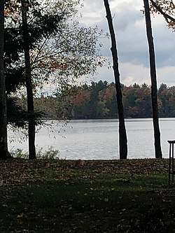 Eastern Shore of Bass Lake | |
 Bass Lake | |
| Location | Grand Traverse County, Michigan (Long Lake Township & Green Lake Township) |
| Coordinates | 44.690560°N 85.710702°W |
| Etymology | Abundance of Bass |
| Primary inflows | Dyer Creek (Dyer Lake), Hendrie Creek |
| Primary outflows | West Branch Beitner Creek, Cox Pond |
| Max. length | 1.6 mi (2.6 km) |
| Max. width | 3,327 ft (1.014 km) |
| Surface area | 344 acres (139 ha) |
| Max. depth | 28 ft (8.5 m) |
| Islands | Namaste Island, Greene Island, Germaine Island, Caroline Island, Phantom Island |
The west branch of Beitner Creek flows out of the lake and into the Boardman River.[1]
The nearest towns are Grawn and Traverse City.
A small settlement called Bass Lake sits on the eastern shore of the lake, at the end of Culver Road.
Most of the lake is located within Long Lake Township, but the southern portion of the lake extends into Green Lake Township.
Camp
Until 1955, Girl Scouts who wanted to camp had to go to Camp Greilick near Arbutus Lake, which was owned by the Boy Scouts (who also outed there). In the summer of that year, a girls scout camp opened on the southwestern shore of the lake known as Camp Sakakawea.[2]
Recreation
In the local area, Bass Lake is used for recreation. It is known locally is a common pike, bluegill and bass fishing lake (hence the name). Boaters on the lake, who commonly water ski on the lake, also visit Long and Darien islands, which are the largest islands in the lake. Boaters access the lake on the northwest shore.
People who live on the lake commonly own smaller cabin houses. Many small hotels are on the lake.[3]
See also
References
- "Natural River Plan: Boardman River" (PDF). Michigan Department of Natural Resources. Retrieved November 24, 2017.
- "Properties | Camp Sakakawea | Girl Scouts of Michigan Shore to Shore". www.gsmists.org. Archived from the original on November 19, 2017. Retrieved November 24, 2017.
- "Bass Lake, Michigan, USA Vacation Info". Lakelubbers. Retrieved November 24, 2017.