Green Lake Township, Michigan
Green Lake Township is a civil township of Grand Traverse County in the U.S. state of Michigan. The population was 5,784 at the 2010 census, an increase from 5,009 at the 2000 census. The township is named after Green Lake, one of two large lakes in the township (the other being Duck Lake).
Green Lake Township, Michigan | |
|---|---|
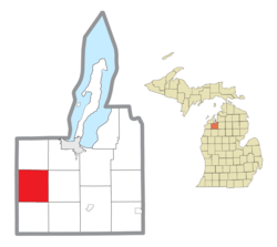 Location within Grand Traverse County | |
 Green Lake Township Location within the state of Michigan | |
| Coordinates: 44°38′37″N 85°45′56″W | |
| Country | United States |
| State | Michigan |
| County | Grand Traverse |
| Area | |
| • Total | 36.3 sq mi (94.1 km2) |
| • Land | 29.4 sq mi (76.1 km2) |
| • Water | 6.9 sq mi (18.0 km2) |
| Elevation | 840 ft (256 m) |
| Population (2010) | |
| • Total | 5,784 |
| • Density | 170.4/sq mi (65.8/km2) |
| Time zone | UTC-5 (Eastern (EST)) |
| • Summer (DST) | UTC-4 (EDT) |
| ZIP code(s) | 49637, 49643, 49685 |
| Area code(s) | 231 |
| FIPS code | 26-34960[1] |
| GNIS feature ID | 1626397[2] |
Communities
- Diamond Park is a small resort community on the western shores of Green Lake.
- Duck Lake Park is a small community on the southeastern shore of Duck Lake.
- Duck Lake Peninsula is a residential community on the peninsula in Duck Lake.
- Interlochen is an unincorporated community within the township known for the Interlochen Center for the Arts. The town is located on M-137.
- Lakeside Resort is a ghost town on the eastern shore of Green Lake.
- Peninsula Resort is a ghost town and residential community on the peninsula in Green Lake.
- Tonawanda is an unincorporated community on an abandoned section of the Great Lakes Central Railroad approximately 1 mi (1.6 km) east of Interlochen.
- Wylie is a ghost town that has been enveloped by the Interlochen Center for the Arts.
Geography
According to the United States Census Bureau, the township has a total area of 36.3 square miles (94 km2), of which 29.4 square miles (76 km2) is land and 6.9 square miles (18 km2) (19.10%) is water.
Demographics
As of the census[1] of 2000, there were 5,009 people, 1,942 households, and 1,419 families residing in the township. The population density was 170.4 per square mile (65.8/km²). There were 2,457 housing units at an average density of 83.6 per square mile (32.3/km²). The racial makeup of the township was 96.95% White, 0.02% African American, 1.22% Native American, 0.42% Asian, 0.06% Pacific Islander, 0.28% from other races, and 1.06% from two or more races. Hispanic or Latino of any race were 0.86% of the population.
There were 1,942 households out of which 34.8% had children under the age of 18 living with them, 61.6% were married couples living together, 8.1% had a female householder with no husband present, and 26.9% were non-families. 20.4% of all households were made up of individuals and 5.4% had someone living alone who was 65 years of age or older. The average household size was 2.58 and the average family size was 3.00.
In the township the population was spread out with 26.4% under the age of 18, 6.5% from 18 to 24, 33.6% from 25 to 44, 22.8% from 45 to 64, and 10.7% who were 65 years of age or older. The median age was 36 years. For every 100 females, there were 100.8 males. For every 100 females age 18 and over, there were 98.2 males.
The median income for a household in the township was $45,884, and the median income for a family was $50,183. Males had a median income of $32,377 versus $27,222 for females. The per capita income for the township was $19,594. About 3.6% of families and 4.5% of the population were below the poverty line, including 4.9% of those under age 18 and 5.4% of those age 65 or over.
References
Municipalities and communities of Grand Traverse County, Michigan, United States | ||
|---|---|---|
| City | 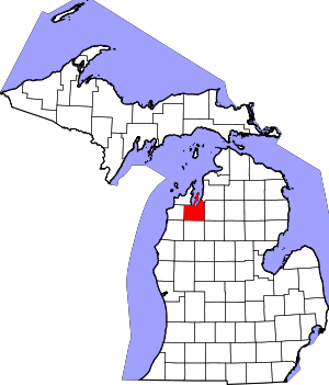 Map of Michigan highlighting Grand Traverse County.svg | |
| Villages | ||
| Charter townships | ||
| General law townships | ||
| CDPs | ||
| Other unincorporated communities | ||
| Indian reservation | ||
| Footnotes | ‡This populated place also has portions in an adjacent county or counties | |