Climate of North Dakota
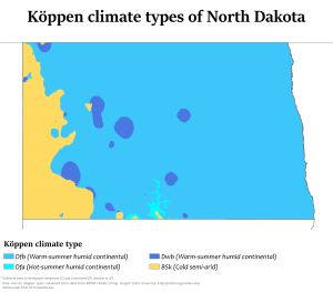
North Dakota's climate is typical of a continental climate with cold winters and warm-hot summers. The state's location in the Upper Midwest allows it to experience some of the widest variety of weather in the United States, and each of the four seasons has its own distinct characteristics. The eastern half of the state has a humid continental climate (Köppen climate classification Dfb) with warm to hot, somewhat humid summers and cold, windy winters, while the western half has a semi-arid climate (Köppen climate classification BSk) with less precipitation and less humidity but similar temperature profiles. The areas east of the Missouri River get slightly colder winters, while those west of the stream get higher summer daytime temperatures. In general, the diurnal temperature difference is prone to be more significant in the west due to higher elevation and less humidity.
General climatology
Due to its location in the center of North America North Dakota experiences temperature extremes characteristic of a continental climate, with cold winters and hot summers.[2] Each season has distinctive upper air patterns which bring different weather conditions with them. One feature of a continental climate is that weather patterns can be unpredictable. For example, an Alberta clipper, a low pressure system originating in the province of Alberta in Canada, would be a common winter occurrence in North Dakota. But with the general unpredictability of weather in a continental climate, such a storm system could occur in spring, or in late autumn. Hot weather, though usually confined to July and August, can sometimes begin as early as April or May, and could spill over into September or October.[3]
Being 1,000 miles (1,609 km) from any large body of water (with the exception of Lake Superior), temperatures and precipitation in North Dakota can vary widely. North Dakota is far enough north to experience −60 °F (−51 °C) temperatures and blizzards during the winter months, but far enough south to experience 121 °F (49 °C) temperatures and tornado outbreaks in the summer.[4] The 181 °F degree (100 °C) variation between North Dakota's highest and lowest temperature is the 3rd largest variation of any U.S. State, and the largest of any non-mountainous state.[5]
North Dakota is far from major sources of moisture and is in the transition zone between the moist East and the semi-arid West, as precipitation and humidity decrease from east to west. Annual average precipitation across the state ranges from around 14 in (35.6 cm) in the west to 22 in (55.9 cm) in the east.[6] Snow is the main form of precipitation from November through March, while rain is the most common the rest of the year. It has snowed in North Dakota during every month except July and August.
Statistics for ThreadEx cities
| Climate data for Bismarck Municipal Airport, North Dakota (1981–2010 normals,[lower-alpha 1] extremes 1874–present[lower-alpha 2]) | |||||||||||||
|---|---|---|---|---|---|---|---|---|---|---|---|---|---|
| Month | Jan | Feb | Mar | Apr | May | Jun | Jul | Aug | Sep | Oct | Nov | Dec | Year |
| Record high °F (°C) | 63 (17) |
73 (23) |
81 (27) |
93 (34) |
102 (39) |
111 (44) |
114 (46) |
109 (43) |
105 (41) |
95 (35) |
79 (26) |
66 (19) |
114 (46) |
| Mean maximum °F (°C) | 46.8 (8.2) |
51.0 (10.6) |
65.7 (18.7) |
81.2 (27.3) |
86.9 (30.5) |
93.2 (34.0) |
98.8 (37.1) |
98.2 (36.8) |
92.2 (33.4) |
81.9 (27.7) |
63.9 (17.7) |
48.5 (9.2) |
101.6 (38.7) |
| Average high °F (°C) | 23.4 (−4.8) |
28.3 (−2.1) |
40.4 (4.7) |
57.0 (13.9) |
68.4 (20.2) |
77.2 (25.1) |
84.7 (29.3) |
83.5 (28.6) |
72.1 (22.3) |
57.5 (14.2) |
39.6 (4.2) |
26.2 (−3.2) |
54.9 (12.7) |
| Daily mean °F (°C) | 12.8 (−10.7) |
18.1 (−7.7) |
29.9 (−1.2) |
43.8 (6.6) |
55.5 (13.1) |
64.7 (18.2) |
71.1 (21.7) |
69.5 (20.8) |
58.5 (14.7) |
44.8 (7.1) |
29.2 (−1.6) |
16.2 (−8.8) |
42.8 (6.0) |
| Average low °F (°C) | 2.2 (−16.6) |
7.9 (−13.4) |
19.4 (−7.0) |
30.7 (−0.7) |
42.7 (5.9) |
52.0 (11.1) |
57.4 (14.1) |
55.5 (13.1) |
44.9 (7.2) |
32.2 (0.1) |
18.8 (−7.3) |
6.1 (−14.4) |
30.8 (−0.7) |
| Mean minimum °F (°C) | −22.8 (−30.4) |
−19.3 (−28.5) |
−5.3 (−20.7) |
13.7 (−10.2) |
27.0 (−2.8) |
38.8 (3.8) |
45.6 (7.6) |
41.6 (5.3) |
28.6 (−1.9) |
15.3 (−9.3) |
−1.7 (−18.7) |
−17.5 (−27.5) |
−29.4 (−34.1) |
| Record low °F (°C) | −45 (−43) |
−45 (−43) |
−36 (−38) |
−12 (−24) |
13 (−11) |
30 (−1) |
32 (0) |
32 (0) |
10 (−12) |
−10 (−23) |
−30 (−34) |
−43 (−42) |
−45 (−43) |
| Average precipitation inches (mm) | 0.43 (11) |
0.51 (13) |
0.87 (22) |
1.26 (32) |
2.40 (61) |
3.17 (81) |
2.89 (73) |
2.28 (58) |
1.59 (40) |
1.25 (32) |
0.71 (18) |
0.49 (12) |
17.85 (453) |
| Average snowfall inches (cm) | 8.9 (23) |
8.1 (21) |
9.1 (23) |
4.2 (11) |
0.4 (1.0) |
0 (0) |
0 (0) |
0 (0) |
0.2 (0.51) |
2.2 (5.6) |
8.8 (22) |
9.3 (24) |
51.2 (130) |
| Average precipitation days (≥ 0.01 in) | 7.5 | 7.0 | 7.9 | 7.4 | 10.1 | 11.2 | 9.7 | 8.2 | 7.5 | 6.6 | 7.0 | 7.6 | 97.7 |
| Average snowy days (≥ 0.1 in) | 9.7 | 8.1 | 6.4 | 2.5 | 0.4 | 0 | 0 | 0 | 0.1 | 1.4 | 6.6 | 10.0 | 45.2 |
| Average relative humidity (%) | 71.3 | 72.4 | 69.9 | 61.8 | 60.1 | 65.0 | 61.8 | 60.6 | 63.7 | 63.8 | 72.0 | 74.5 | 66.4 |
| Mean monthly sunshine hours | 149.4 | 153.5 | 222.3 | 244.3 | 296.1 | 318.1 | 354.6 | 316.2 | 245.9 | 191.7 | 122.6 | 122.9 | 2,737.6 |
| Percent possible sunshine | 53 | 53 | 60 | 60 | 64 | 67 | 74 | 72 | 65 | 57 | 43 | 46 | 61 |
| Source: NOAA (relative humidity and sun 1961–1990),[7][8][9] The Weather Channel[10] | |||||||||||||
| Climate data for Fargo, North Dakota (Hector Int'l), 1981–2010 normals,[lower-alpha 3] extremes 1881–present[lower-alpha 4] | |||||||||||||
|---|---|---|---|---|---|---|---|---|---|---|---|---|---|
| Month | Jan | Feb | Mar | Apr | May | Jun | Jul | Aug | Sep | Oct | Nov | Dec | Year |
| Record high °F (°C) | 55 (13) |
66 (19) |
80 (27) |
100 (38) |
104 (40) |
104 (40) |
114 (46) |
106 (41) |
102 (39) |
97 (36) |
74 (23) |
65 (18) |
114 (46) |
| Mean maximum °F (°C) | 39.6 (4.2) |
43.1 (6.2) |
57.0 (13.9) |
79.9 (26.6) |
88.1 (31.2) |
91.6 (33.1) |
94.0 (34.4) |
93.8 (34.3) |
89.2 (31.8) |
78.2 (25.7) |
59.3 (15.2) |
41.2 (5.1) |
94.0 (34.4) |
| Average high °F (°C) | 18.4 (−7.6) |
23.7 (−4.6) |
36.3 (2.4) |
55.8 (13.2) |
69.3 (20.7) |
77.4 (25.2) |
82.5 (28.1) |
81.2 (27.3) |
70.8 (21.6) |
56.0 (13.3) |
37.3 (2.9) |
22.3 (−5.4) |
52.6 (11.4) |
| Daily mean °F (°C) | 9.3 (−12.6) |
14.6 (−9.7) |
27.8 (−2.3) |
44.2 (6.8) |
57.1 (13.9) |
66.2 (19.0) |
71.0 (21.7) |
69.3 (20.7) |
59.1 (15.1) |
45.5 (7.5) |
28.8 (−1.8) |
14.1 (−9.9) |
42.3 (5.7) |
| Average low °F (°C) | 0.1 (−17.7) |
5.6 (−14.7) |
19.4 (−7.0) |
32.7 (0.4) |
44.9 (7.2) |
55.0 (12.8) |
59.5 (15.3) |
57.3 (14.1) |
47.4 (8.6) |
35.1 (1.7) |
20.3 (−6.5) |
5.9 (−14.5) |
31.9 (0.0) |
| Mean minimum °F (°C) | −22.5 (−30.3) |
−19 (−28) |
−6.1 (−21.2) |
16.9 (−8.4) |
28.6 (−1.9) |
41.1 (5.1) |
47.1 (8.4) |
43.4 (6.3) |
30.7 (−0.7) |
19.3 (−7.1) |
0.3 (−17.6) |
−16.6 (−27.0) |
−22.5 (−30.3) |
| Record low °F (°C) | −48 (−44) |
−47 (−44) |
−34 (−37) |
−13 (−25) |
14 (−10) |
28 (−2) |
36 (2) |
32 (0) |
17 (−8) |
−4 (−20) |
−27 (−33) |
−36 (−38) |
−48 (−44) |
| Average precipitation inches (mm) | 0.70 (18) |
0.61 (15) |
1.30 (33) |
1.36 (35) |
2.81 (71) |
3.90 (99) |
2.79 (71) |
2.56 (65) |
2.57 (65) |
2.15 (55) |
1.00 (25) |
0.83 (21) |
22.58 (573) |
| Average snowfall inches (cm) | 11.2 (28) |
7.0 (18) |
9.1 (23) |
3.0 (7.6) |
0.0 (0.0) |
0.0 (0.0) |
0.0 (0.0) |
0.0 (0.0) |
0.0 (0.0) |
0.7 (1.8) |
7.9 (20) |
11.2 (28) |
50.1 (126.4) |
| Average precipitation days (≥ 0.01 in) | 8.3 | 7.2 | 8.3 | 7.4 | 11.0 | 11.7 | 9.5 | 9.1 | 8.7 | 8.3 | 7.1 | 9.2 | 105.8 |
| Average snowy days (≥ 0.1 in) | 8.9 | 6.7 | 5.3 | 1.8 | 0.0 | 0.0 | 0.0 | 0.0 | 0.0 | 0.8 | 5.4 | 9.5 | 38.4 |
| Average relative humidity (%) | 73.1 | 74.7 | 76.0 | 65.6 | 60.0 | 66.1 | 66.9 | 66.5 | 69.2 | 68.8 | 75.7 | 76.1 | 69.9 |
| Mean monthly sunshine hours | 140.9 | 153.9 | 212.3 | 241.6 | 283.2 | 303.2 | 350.2 | 313.2 | 231.2 | 178.9 | 113.1 | 107.4 | 2,629.1 |
| Percent possible sunshine | 51 | 53 | 58 | 59 | 61 | 64 | 73 | 71 | 61 | 53 | 40 | 40 | 57 |
| Average ultraviolet index | 1 | 2 | 3 | 5 | 6 | 8 | 8 | 7 | 5 | 3 | 1 | 1 | 4 |
| Source 1: NOAA (relative humidity and sun 1961–1990)[11][12][13][14] | |||||||||||||
| Source 2: Weather Atlas [15] | |||||||||||||
| Climate data for Grand Forks International Airport, North Dakota (1981–2010 normals,[16] extremes 1893–present[17] | |||||||||||||
|---|---|---|---|---|---|---|---|---|---|---|---|---|---|
| Month | Jan | Feb | Mar | Apr | May | Jun | Jul | Aug | Sep | Oct | Nov | Dec | Year |
| Record high °F (°C) | 52 (11) |
67 (19) |
83 (28) |
100 (38) |
105 (41) |
105 (41) |
109 (43) |
104 (40) |
103 (39) |
95 (35) |
75 (24) |
58 (14) |
109 (43) |
| Mean maximum °F (°C) | 39.2 (4.0) |
42.0 (5.6) |
54.2 (12.3) |
78.1 (25.6) |
87.2 (30.7) |
90.3 (32.4) |
92.3 (33.5) |
93.5 (34.2) |
89.1 (31.7) |
76.3 (24.6) |
57.4 (14.1) |
40.3 (4.6) |
96.0 (35.6) |
| Average high °F (°C) | 16.5 (−8.6) |
21.9 (−5.6) |
34.2 (1.2) |
53.9 (12.2) |
68.0 (20.0) |
76.1 (24.5) |
81.0 (27.2) |
80.2 (26.8) |
69.6 (20.9) |
54.3 (12.4) |
35.1 (1.7) |
20.3 (−6.5) |
51.1 (10.6) |
| Average low °F (°C) | −3.1 (−19.5) |
2.1 (−16.6) |
16.1 (−8.8) |
30.0 (−1.1) |
41.5 (5.3) |
52.0 (11.1) |
56.3 (13.5) |
54.0 (12.2) |
44.2 (6.8) |
31.9 (−0.1) |
17.0 (−8.3) |
2.6 (−16.3) |
28.9 (−1.7) |
| Mean minimum °F (°C) | −25.4 (−31.9) |
−21.4 (−29.7) |
−8.2 (−22.3) |
16.2 (−8.8) |
27.6 (−2.4) |
40.3 (4.6) |
46.0 (7.8) |
41.3 (5.2) |
30.1 (−1.1) |
17.3 (−8.2) |
−2 (−19) |
−18.9 (−28.3) |
−29 (−34) |
| Record low °F (°C) | −43 (−42) |
−42 (−41) |
−36 (−38) |
−9 (−23) |
5 (−15) |
28 (−2) |
30 (−1) |
30 (−1) |
11 (−12) |
−9 (−23) |
−35 (−37) |
−37 (−38) |
−43 (−42) |
| Average precipitation inches (mm) | 0.55 (14) |
0.52 (13) |
0.96 (24) |
1.01 (26) |
2.68 (68) |
3.48 (88) |
3.15 (80) |
2.88 (73) |
2.05 (52) |
1.97 (50) |
0.95 (24) |
0.61 (15) |
20.81 (527) |
| Average snowfall inches (cm) | 10.7 (27) |
6.6 (17) |
7.2 (18) |
2.6 (6.6) |
0.1 (0.25) |
0 (0) |
0 (0) |
0 (0) |
trace | 1.5 (3.8) |
7.7 (20) |
10.7 (27) |
47.1 (120) |
| Average precipitation days (≥ 0.01 in) | 8.1 | 6.6 | 7.5 | 7.0 | 10.6 | 11.6 | 10.5 | 9.1 | 8.3 | 8.5 | 6.9 | 8.5 | 103.2 |
| Average snowy days (≥ 0.1 in) | 10.1 | 7.1 | 5.5 | 1.9 | 0.2 | 0 | 0 | 0 | 0 | 1.3 | 5.6 | 9.8 | 41.5 |
| Source: NOAA[18][19] | |||||||||||||
| Climate data for Williston, North Dakota (Sloulin Int'l), 1981–2010 normals, extremes 1894–present[lower-alpha 5] | |||||||||||||
|---|---|---|---|---|---|---|---|---|---|---|---|---|---|
| Month | Jan | Feb | Mar | Apr | May | Jun | Jul | Aug | Sep | Oct | Nov | Dec | Year |
| Record high °F (°C) | 58 (14) |
66 (19) |
84 (29) |
92 (33) |
106 (41) |
108 (42) |
110 (43) |
108 (42) |
104 (40) |
93 (34) |
76 (24) |
63 (17) |
110 (43) |
| Average high °F (°C) | 22 (−6) |
28 (−2) |
40 (4) |
57 (14) |
68 (20) |
77 (25) |
84 (29) |
84 (29) |
71 (22) |
56 (13) |
38 (3) |
24 (−4) |
54 (12) |
| Average low °F (°C) | 0 (−18) |
6 (−14) |
18 (−8) |
30 (−1) |
41 (5) |
50 (10) |
56 (13) |
54 (12) |
42 (6) |
30 (−1) |
16 (−9) |
3 (−16) |
29 (−2) |
| Record low °F (°C) | −42 (−41) |
−50 (−46) |
−35 (−37) |
−15 (−26) |
10 (−12) |
26 (−3) |
34 (1) |
32 (0) |
13 (−11) |
−9 (−23) |
−27 (−33) |
−50 (−46) |
−50 (−46) |
| Average precipitation inches (mm) | 0.6 (15) |
0.4 (10) |
0.7 (18) |
1 (25) |
1.9 (48) |
2.5 (64) |
2.5 (64) |
1.5 (38) |
1.1 (28) |
0.9 (23) |
0.7 (18) |
0.6 (15) |
14.4 (366) |
| Average snowfall inches (cm) | 10.0 (25) |
5.7 (14) |
6.2 (16) |
3.7 (9.4) |
1.3 (3.3) |
0.0 (0.0) |
0.0 (0.0) |
0.0 (0.0) |
0.2 (0.51) |
2.6 (6.6) |
6.1 (15) |
9.5 (24) |
45.3 (113.81) |
| Average precipitation days (≥ 0.01 in) | 8 | 6 | 8 | 8 | 10 | 12 | 9 | 8 | 7 | 6 | 7 | 9 | 98 |
| Average snowy days (≥ 0.1 in) | 9 | 6 | 6 | 2 | 1 | 0 | 0 | 0 | 0 | 2 | 6 | 9 | 41 |
| Average relative humidity (%) | 76 | 76 | 73 | 61 | 59 | 60 | 56 | 55 | 61 | 65 | 75 | 77 | 66 |
| Mean monthly sunshine hours | 145 | 170 | 227 | 250 | 298 | 326 | 366 | 332 | 250 | 197 | 122 | 126 | 2,809 |
| Percent possible sunshine | 53 | 59 | 62 | 61 | 63 | 68 | 76 | 75 | 66 | 59 | 44 | 48 | 63 |
| Source: NOAA (relative humidity 1962–1990, sun 1961–1990)[lower-alpha 6][21][22][23] | |||||||||||||
Demographics
| Historical population | |||
|---|---|---|---|
| Census | Pop. | %± | |
| 1890 | 295 | — | |
| 1900 | 763 | 158.6% | |
| 1910 | 3,124 | 309.4% | |
| 1920 | 4,178 | 33.7% | |
| 1930 | 5,106 | 22.2% | |
| 1940 | 5,790 | 13.4% | |
| 1950 | 7,398 | 27.8% | |
| 1960 | 11,866 | 60.4% | |
| 1970 | 11,230 | −5.4% | |
| 1980 | 13,336 | 18.8% | |
| 1990 | 13,136 | −1.5% | |
| 2000 | 12,512 | −4.8% | |
| 2010 | 14,716 | 17.6% | |
| Est. 2019 | 29,033 | [24] | 97.3% |
| U.S. Decennial Census[25] 2018 Estimate[26] | |||
Williston is in northwestern North Dakota's booming oil patch where adequate, affordable housing has become a concern.[27] According to a February 2014 article in Business Insider, Williston had the highest apartment rents in the United States.[28] The 2010 census counted a population of 14,716, up from 12,680 in 2000, but the number of current residents is likely much higher because the count did not include those living in temporary housing. In September 2011, the mayor estimated the actual population at 20,000.[29] The aforementioned 2014 Business Insider story estimated that the population was over 30,000.[28]
2010 census
As of the census[30] of 2010, there were 14,716 people, 6,180 households, and 3,589 families residing in the city. The population density was 1,962.1 inhabitants per square mile (757.6/km2). There were 6,542 housing units at an average density of 872.3 per square mile (336.8/km2). The racial makeup of the city was 92.6% White, 0.3% African-American, 3.3% Native American or Alaska Native, 0.3% Asian, 0.4% from other races, and 3.0% from two or more races. Hispanics or Latinos of any race were 2.2% of the population.
There were 6,180 households of which 29.0% had children under the age of 18 living with them, 44.6% were married couples living together, 9.0% had a female householder with no husband present, 4.5% had a male householder with no wife present, and 41.9% were non-families. 34.6% of all households were made up of individuals and 12.3% had someone living alone who was 65 years of age or older. The average household size was 2.31 and the average family size was 2.99.
The median age in the city was 35.5 years. 23.6% of residents were under the age of 18; 10% were between the ages of 18 and 24; 26.7% were from 25 to 44; 25.4% were from 45 to 64; and 14.4% were 65 years of age or older. The gender makeup of the city was 51.0% male and 49.0% female.
2000 census
According to the census of 2000, there were 12,512 people, 5,255 households, and 3,205 families residing in the city. The population density was 1,794.1 per square mile (693.1/km²). There were 5,912 housing units at an average density of 847.7 per square mile (327.5/km²). The racial makeup of the city was 93.69% White, 0.17% African American, 3.65% Native American or Alaska Native, 0.24% Asian, 0.02% Pacific Islander, 0.17% from other races, and 2.06% from two or more races. Hispanics or Latinos of any race were 1.23% of the population.
The six leading ancestry groups in the city are Norwegian (47.8%), German (31.6%), Irish (9.6%), English (5.8%), Swedish (4.5%), Dutch (4.3%) and French (4.0%).
There were 5,255 households, of which 30.7% had children under the age of 18 living with them, 47.4% were married couples living together, 10.5% had a female householder with no husband present, and 39.0% were non-families. 34.1% of all households were made up of individuals and 13.7% had someone living alone who was 65 years of age or older. The average household size was 2.30 and the average family size was 2.96.
The age distribution was 25.6% under the age of 18, 9.3% from 18 to 24, 25.8% from 25 to 44, 22.5% from 45 to 64, and 16.8% who were 65 years of age or older. The median age was 38 years. For every 100 females, there were 91.9 males. For every 100 females age 18 and over, there were 88.3 males.
The median income for a household in the city was $29,962, and the median income for a family was $38,713. Males had a median income of $29,578 versus $18,879 for females. The per capita income for the city was $16,656. About 11.3% of families and 13.4% of the population were below the poverty line, including 19.1% of those under age 18 and 7.8% of those age 65 or over.
Economy
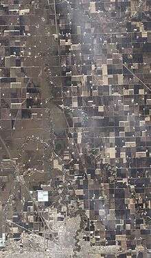
Williston's economy, while historically agricultural, is increasingly being driven by the oil industry. Williston lends its name to the Williston Basin, a huge subterranean geologic feature known for its rich deposits of petroleum, coal, and potash. Williston sits atop the Bakken formation, which by the end of 2012 was predicted to be producing more oil than any other site in the United States, surpassing even Alaska's Prudhoe Bay, the longtime leader in domestic output in the United States.[31]
(The state of North Dakota provides a website detailing daily oil activity.) In 1995, the U.S. Geological Survey estimated that there were 150 million barrels of oil "technically recoverable" from the Bakken shale. In April 2008, the number was said to be about four billion barrels; in 2010 geologists at Continental Resources, the major drilling operation in North Dakota, estimated the reserve at eight billion. In March 2012, after the discovery of a lower shelf of oil, it announced a possible 24 billion barrels. Although current technology allows for extraction of only about 6% of the oil trapped 0.99–1.99 mi (1.6–3.2 km) beneath the earth's surface, recoverable oil might eventually exceed 500 billion barrels.[31] [The recoverable oil amount in the WSJ article may be a misprint. Continental Resources estimates of original oil in place (OOIP) is 500 billion bbls of oil. Primary production using new technology could increase primary recover to 10% or 50 billion bbls of recoverable oil. Some suggest as much as 20% which would be 100 billion bbls. Other recovery rates are estimated at 3 – 8% currently, or 15 billion to 40 billion bbls of recoverable oil.]
Williston has seen a huge increase in population and infrastructure investments during the last several years with expanded drilling using the Hydraulic Fracturing petroleum extraction technique in the Bakken Formation and Three Forks Groups.[32] Examples of oil industry related infrastructure investments are the multi-acre branch campus of Baker Hughes, the Sand Creek Retail Center, and the Jim Bridger shops & offices.
A major regional grain elevator is served by the BNSF Railway. Williston's livestock arena has weekly auctions.
Forts Union and Buford, as well as the confluence of the Yellowstone and Missouri Rivers—a part of the history of the Lewis and Clark Expedition—encourage area tourism. Williston is also comparatively close to the North Unit of Theodore Roosevelt National Park.
Arts and culture
Sites of interest
- Fort Union Trading Post National Historic Site – a reconstructed fur-trade era fort owned and maintained by the National Park Service.
- Fort Buford – a pioneer age military fort. An interesting site is the military graveyard.
- Missouri-Yellowstone Confluence Interpretive Center – A museum highlighting the history of the area where the Missouri River and the Yellowstone River merge.
- Lake Sakakawea – a large man-made lake located close to Williston. The lake offers plenty of recreational activities.
- The Confluence – where the Missouri River and the Yellowstone River meet. A historical center, boat ramp, camp site, and bike path are located here.
- Eagle Ridge Golf Club – an eighteen-hole golf course located on Highway 2 north of Williston. It measures 6,240 yards (5,710 m) from the back tees.
- Williston Municipal Golf Course – a 9-hole golf course located at 3600 42nd Street West in Williston.
- The Links of North Dakota at Red Mike Resort – an 18-hole links course east of Williston. Golfweek ranked it 41st among America's 100 best modern courses in 1997, 75th in 1998, and 81st in 1999.
- Cut Bluff Overlook – a historic site located about two miles (3 km) east of Williston on the south side of Highway 1804. Commemorating Lewis and Clark's campsite near Cut Bluff on the south banks of the Missouri River.
- James Memorial Art Center – Originally the community library (est 1911), The James was added to the National Register of Historic Places in 1979.It now serves as an art & cultural center for the community, offering art exhibits and art classes.[33]
- Old Armory – The Old Armory was built in 1915 and listed on the National Register of Historic Places in 1985.[34] The Old Armory is now home to community theater non-profit organization Entertainment, Inc!, founded in 1981. Entertainment, Inc! produces five shows each year.[35]
- Williston Area Recreation Center – a 234,000 square foot recreation center, built in 2014, that includes an indoor surfing, golf simulators, and a water park. There are also the more traditional tennis and basketball courts, along with turf fields and an indoor track.[36]
Sports
- Williston Keybirds of North Dakota American League Baseball
- Williston State College Tetons: women's and men's basketball, women's volleyball, men's ice hockey, women's softball and men's baseball.
Education
The Williston Public School District #1 serves the city. The surrounding rural area is served by New Public School District 8. Trinity Christian School is a private K-12 school located in Williston. St. Joseph Catholic School is a private K-6 school located in Williston.
Williston State College, on University Avenue, was founded in 1961 as the University of North Dakota—Williston (UND-W) and is a two-year public college in the North Dakota University System (NDUS). Students can earn Associate in Arts (AA), Associate in Science (AS), and Associate of Applied Science (AAS) degrees.
The Williston Public Library also serves as the public library for Williams County. The library hosts an annual fundraiser called "Table of Contents" where local patrons create unique table arrangements and dining themes. Proceeds are used to purchase equipment for local organizations holding public meetings at the library.[37] Numerous public events, including voting stations, are regularly held at the library.
The library also has a bookmobile that serves rural schools and retirement home communities.[38]
Prior to moving to the Davidson Drive location, the Williston Public Library was located in what is now the James Memorial Art Center which is now an art gallery and event center. From February 27, 1911, until 1983, the James Memorial Library was the town's only library. In the early 1990s the city began to address the issue of probable building destruction. In 1993 a concerned group of citizens formed the James Memorial Preservation Society to save the historic building and develop it into a center for the visual arts.[39] The James Memorial Art Center now hosts an annual Art Fest, art classes for youth and adults, and exhibits by local, national, and international artists.
Media
Print
- Williston Herald
- Plains Reporter
- Oil Patch Hotline
- The Christian Weekly
- The Williston Trader
- The Shopper
Television
- 4.1 KWSE (PBS) Prairie Public Television
- 4.2 World
- 4.3 Minnesota Channel
- 4.4 Lifelong Learning
- 8.1 KUMV (NBC)
- 11.1 KXMD (CBS)
- 38.1 KXND-LP (Fox; rebroadcasts KUMV-TV 8.2)
In the late 1970s and early 1980s, KXMD and KUMV were rebroadcast across Saskatchewan as part of that region's first terrestrial-based cable television system. By 1984, however, the Williston signals had been replaced by those of similar stations in Detroit.
Radio
- FM
- 88.1 K201FJ CSN network – Christian
- 89.5 KPPR North Dakota Public Radio/NPR affiliate
- 90.3 K212DW K-LOVE network – contemporary Christian music
- 90.7 KJND-FM Your Network of Praise – Christian
- 91.7 K219CB American Family Radio network – Christian
- 93.1 KGCX "Eagle 93" Classic rock – based in Sidney, Montana
- 95.1 KTHC "Power 95.1" Hot Adult Contemporary
- 96.1 KYYZ "Z96.1 Country Thunder" Country
- 101.1 KDSR "Hot 101" Jack FM
- 102.7 KHRT translator - contemporary christian music
- AM
- 660 KEYZ "Keyz NewsRadio" News/Talk/Country
- 1070 KATQ Country – based in Plentywood, Montana
- 1090 KTGO Country - basin in Tioga
Infrastructure
Transportation
Air
The city of Williston is served by the Williston Basin International Airport, which has a customs service in its facilities. The facility opened in October 2019, replacing Sloulin Field International Airport.[40]
In 2012, United Airlines began offering daily codeshare jet service (via ExpressJet Airlines) to Denver, CO (KDEN) on Embraer 145 aircraft, while Delta Air Lines began daily codeshare jet service (via SkyWest Airlines) to Minneapolis, MN (MSP) on Bombardier CRJ200 aircraft. In August 2014, United began offering direct flights to Houston TX. In June 2020, Delta Airlines announced that it would suspend service to Williston, effective July 8.[41]
FedEx Express of Memphis, TN, provides cargo flights to and from the Williston, ND Airport and Grand Forks, ND (GFK) airport utilizing Cessna 208B Caravans with CargoMaster cargo pods. These flights run Monday through Saturday. The Saturday service has an early cutoff time and pickups are limited to in-town stops and drop box locations only.
Rail
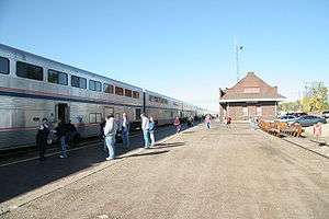
Amtrak, the national passenger rail system, serves a station in Williston via its Empire Builder, a once-daily train in each direction between Portland, Oregon/Seattle, Washington, and Chicago.
Highways
US 2 runs through the city. US 85 bypasses the city to the northwest, and US 85B bypasses the city to the northeast. ND 1804 runs through the southern portion of the city and is concurrent with US 2 between 143rd Avenue, and 2nd Street.
Health Care
Williston clinics include Craven-Hagan Clinic, Fairlight Medical Center, and Trinity Community Clinic-Western Dakota. Fairlight has the only Veteran's Affairs clinic in northwestern North Dakota and also serves residents of northeastern Montana. Fairlight includes a walk-in clinic with four health care professionals. Mercy Medical Center is the Williston hospital. It provides 24-hour emergency and trauma care but lacks a walk-in clinic.
Mercy Medical Center is home to the Leonard P. Nelson Family Cancer Treatment Center (est. 1996), providing oncology services in the region for the past seventeen years to an area of a 100-mile radius. Patients receive treatment for a wide variety of cancers including breast, gynecologic, head and neck, lung and prostate. Mercy Medical Center broke ground August 24, 2012 on an expanded cancer treatment facility. Improvements include the installation of a highly specialized linear accelerator to increase precision radiation therapy treatment delivery with decreased patient treatment time. The grand opening was October 7, 2013.[42]
Mercy Medical Center was named among the Top 100 Critical Access Hospitals (CAHs) in the United States by The Joint Commission on Accreditation of Healthcare Organizations in September 2012.[43]
Notable people
- Lt-Gen James A. Abrahamson, retired USAF officer and first head of the Strategic Defense Initiative a.k.a. "Star Wars"
- Larry Bergh, selected by the Chicago Bulls in the 1969 NBA draft, but never played
- James R. Carrigan, United States District Court judge and Colorado Supreme Court justice, practiced law in Williston
- Sally Fraser, actress, born in Williston
- Virgil Hill, silver medalist Olympic boxer (1984), four-time world champion boxer who lost his title to Xue Li
- Darlene Hooley, congresswoman from Oregon
- Phil Jackson, 11-time NBA championship head coach
- Mark Lee, pitcher with the Kansas City Royals, Milwaukee Brewers, and Baltimore Orioles
- Brent Qvale, professional football player
- Brian Qvale, professional basketball player
Notes
- Mean monthly maxima and minima (i.e. the highest and lowest temperature readings during an entire month or year) calculated based on data at said location from 1981 to 2010.
- Records for Bismarck have been kept at the Bismarck Municipal Airport since January 1948 and at an undisclosed location from October 1874 to December 1947.
- Mean monthly maxima and minima (i.e. the highest and lowest temperature readings during an entire month or year) calculated based on data at said location from 1981 to 2010.
- Official records for Fargo were kept at the Weather Bureau Office in Moorhead, Minnesota from January 1881 to January 1942, and at Hector Int'l since February 1942. For more information, see ThreadEx
- Official records for Williston kept at the Weather Bureau Office from January 1894 to June 1948 and at Sloulin Int'l since July 1948.[20]
- Only 22 to 24 years out of the 29 in the normals period were used to calculate the humidity normals.
References
- Galadriel Findlay Watson (2001). North Dakota. Weigl Publishers Inc. p. 8. ISBN 1-930954-53-0. Retrieved September 4, 2009.
- "NCRFC Climate and Topography". NOAA. Retrieved November 10, 2006.
- "Mid-April Heat Wave". Minnesota Climatology Office. April 15, 2002. Retrieved November 10, 2006.
- "North Dakota – Climate". City-Data. Retrieved August 20, 2007.
- "U.S. Extreme Record Temps & Differences". Golden Gate Weather Services. 2005. Retrieved November 23, 2006.
- "Climate of North Dakota" (PDF). National Weather Service Forecast Office. Archived from the original (PDF) on September 26, 2007. Retrieved August 20, 2007.
- "NOWData - NOAA Online Weather Data". National Oceanic and Atmospheric Administration. Retrieved December 24, 2015.
- "Station Name: ND BISMARCK". National Oceanic and Atmospheric Administration. Retrieved March 13, 2014.
- "WMO Climate Normals for BISMARCK/MUNICIPAL, ND 1961–1990". National Oceanic and Atmospheric Administration. Retrieved March 10, 2014.
- "Average Weather for Bismarck, ND - Temperature and Precipitation". The Weather Channel. Retrieved May 14, 2010.
- "NowData – NOAA Online Weather Data". National Oceanic and Atmospheric Administration. Retrieved April 12, 2018.
- "Thread Stations Extremes". National Oceanic and Atmospheric Administration. Retrieved September 13, 2011.
- "Station Name: ND FARGO HECTOR INTL AP". National Oceanic and Atmospheric Administration. Retrieved March 13, 2014.
- "WMO Climate Normals for FARGO/WSO AP ND 1961–1990". National Oceanic and Atmospheric Administration. Retrieved March 10, 2014.
- "Fargo, North Dakota, USA – Monthly weather forecast and Climate data". Weather Atlas. Retrieved July 4, 2019.
- Mean monthly maxima and minima (i.e. the highest and lowest temperature readings during an entire month or year) calculated based on data at said location from 1981 to 2010.
- Records for Grand Forks have been kept at the Grand Forks International Airport since April 1965, the former Grand Forks Municipal Airport from September 1948 through March 1965, and at Grand Forks University from January 1893 to August 1948.
- "NOWData - NOAA Online Weather Data". National Oceanic and Atmospheric Administration. Retrieved August 29, 2017.
- "Station Name: ND GRAND FORKS INTL AP". National Oceanic and Atmospheric Administration. Retrieved August 29, 2017.
- ThreadEx
- "NowData - NOAA Online Weather Data". National Oceanic and Atmospheric Administration. Retrieved June 28, 2013.
- "Station Name: ND WILLISTON SLOULIN INTL AP". National Oceanic and Atmospheric Administration. Retrieved March 26, 2014.
- "WMO Climate Normals for WILLISTON/SLOULIN FIELD, ND 1961–1990". National Oceanic and Atmospheric Administration. Retrieved March 10, 2014.
- "Population and Housing Unit Estimates". Retrieved May 21, 2020.
- "U.S. Decennial Census". Census.gov. Retrieved May 25, 2013.
- "Population Estimates". United States Census Bureau. Retrieved October 3, 2018.
- Meg Lindholm, "Flock To N.D. Oil Town Leads To Housing Crisis," NPR, 28 May 2010
- Johnson, Robert (February 13, 2014). "What Life Is Like In Williston, The North Dakota Oil Boomtown Where Tiny Apartments Top $2,000 A Month". Business Insider. Retrieved September 1, 2014.
- NPR website.
- "U.S. Census website". United States Census Bureau. Retrieved June 14, 2012.
- Moore, Stephen (March 11, 2012). "What North Dakota Could Teach California". Wall Street Journal. Retrieved March 19, 2012.
- Seattle Times.
- http://thejamesmemorial.org/historical-notes/
- "Archived copy". Archived from the original on December 4, 2010. Retrieved May 2, 2017.CS1 maint: archived copy as title (link)
- http://www.entertainmentinc.org/AboutUs.aspx
- http://www.businessweek.com/articles/2014-06-18/a-70-million-rec-center-brings-indoor-surfing-golf-to-north-dakota
- http://www.willistonherald.com/archives/tables-of-contents-to-be-held-at-library/article_80132da7-f44a-5797-ad3f-52426dbe2819.html
- http://www.willistonherald.com/news/bookmobile-takes-library-on-the-road/article_7c885eb8-7a11-11e3-a38a-0019bb2963f4.html
- http://www.thejamesmemorial.org/what-we-do/
- Melberg, Mitch (October 10, 2019). "Welcome to the people's airport: First flight lands at Williston Basin International Airport". Retrieved October 11, 2019.
- https://news.delta.com/delta-suspend-flying-select-us-cities
- http://www.mercy-williston.org/News/Leonard-P-Nelson-Cancer-Center-Grand-Opening
- http://www.beckershospitalreview.com/news-analysis/top-100-critical-access-hospitals-named-by-ivantage.html
External links
| Wikimedia Commons has media related to Climate of North Dakota. |
| Wikivoyage has a travel guide for Williston (North Dakota). |
Municipalities and communities of Williams County, North Dakota, United States | ||
|---|---|---|
| Cities | 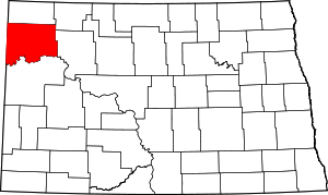 Map of North Dakota highlighting Williams County | |
| Townships |
| |
| Unorganized territories |
| |
| Unincorporated communities | ||
| Indian reservation | ||
| Footnotes | ‡This populated place also has portions in an adjacent county or counties | |

Seasons
Winter in North Dakota is characterized by cold (below freezing) temperatures and snowfall. Snow is the main form of winter precipitation, but freezing rain, ice, sleet, and sometimes even rain are all possible during the winter months. Common storm systems include Alberta clippers or Panhandle hooks, some of which evolve into blizzards. Annual snowfall averages from 26 inches (66 cm) in the central part of the state to 38 inches (96.5 cm) in the northeast and southwest.[1] Temperatures as low as −60 °F (−51 °C) have occurred during North Dakota winters.[2]
Spring is a time of major transition in North Dakota. Early spring commonly sees snowstorms, but by late spring as temperatures begin to moderate the state can experience tornado outbreaks, a risk which diminishes but does not cease through the summer and into the fall as North Dakota lies at the northern edge of Tornado Alley. Springtime flooding is a relatively common event in the Red River Valley, due to the river flowing north into Canada. The spring melt and the eventual runoff typically begins earlier in the southern part of the valley than in the northern part.[3] The most destructive flooding in eastern North Dakota occurred in 1997, which caused extensive damage to Grand Forks.[4]
Summer sees heat and humidity predominate in the east, while hotter and less humid conditions are generally present in the west. These humid conditions help kick off thunderstorm activity 22–34 days a year. Summer high temperatures in North Dakota average in the mid 80s (30 °C) in the west to the upper 70s (25 °C) in the east, with temperatures as hot as 121 °F (49 °C) possible.[2] The growing season in North Dakota usually begins in April, and harvest begins in September and October. Tornadoes are possible in North Dakota from April through October, but the peak tornado month is July, followed by June and August. The state averages 13 tornadoes per year. Depending on location, average annual precipitation ranges from 14 in (35.6 cm) to 22 in (55.9 cm).[5]
Autumn weather in North Dakota is largely the reverse of spring weather. The jet stream, which tends to weaken in summer, begins to re-strengthen, leading to a quicker changing of weather patterns and an increased variability of temperatures. By late October and November these storm systems become strong enough to form major winter storms. Fall and spring are the windiest times of the year in North Dakota.
2017 drought
As of September 2017, the United States Drought Monitor recorded abnormally dryweather conditions across the entire state.[6] The drought is considered severe and unprecedented, and because of its nature as a "unpredictable, sudden event brought on by sustained high temperatures and little rain", it is considered a “flash drought”.[7] North Dakota Agriculture Commissioner Doug Goehring announced that predicted economic losses as a consequence from the drought could amount to as much as $4 billion or $5 billion.[8][9]
See also
Notes
References
- "Climate of North Dakota". Northern Prairie Wildlife Research Center. Retrieved August 21, 2007.
- "Anatomy of a Red River Flood". National Weather Service Weather Forecast Office. Retrieved August 19, 2007.
- "The Grand Forks Flood". Alan Draves. 2002. Retrieved August 20, 2007.
- "United States Drought Monitor > Home > State Drought Monitor". droughtmonitor.unl.edu. Retrieved September 7, 2017.
- McLaughlin, Kathleen (September 7, 2017). "The unprecedented drought that's crippling Montana and North Dakota". The Guardian. ISSN 0261-3077. Retrieved September 7, 2017.
- Service, John Hageman Forum News. "'History is being made' Farmers, ranchers assess impact of North Dakota drought". Bismarck Tribune. Retrieved September 7, 2017.
- Service, April Baumgarten Forum News. "Drought's toll likely billions of dollars for North Dakota economy". Bismarck Tribune. Retrieved September 7, 2017.