Alberta clipper
An Alberta clipper, also known as a Canadian clipper, is a fast moving low pressure area weather system which generally affects the central provinces of Canada and parts of the Upper Midwest, Great Lakes, and New England, precipitating a sudden temperature drop and sharp winds.[1] Alberta clippers take their name from Alberta, the province from which they appear to descend, and from clipper ships of the 19th century, one of the fastest ships of that time.[2]
Formation
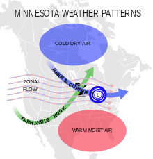
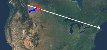
A clipper originates when warm, moist winds from the Pacific Ocean come into contact with the mountains in the provinces of British Columbia and then Alberta.[1] The air travels down the lee side of the mountains, often forming a chinook in Alberta, then develops into a storm over the Canadian prairies when it becomes entangled with the cold air mass that normally occupies that region in winter. The storm then moves east-southeast riding the jet stream, and passes off the upper Atlantic Coast, normally north of Delaware Bay.
The chinook which in part originates the Alberta clipper usually brings relatively warm weather (often approaching 10 °C/50 °F in the depths of winter) to southern Alberta itself, and the term is therefore not used in Alberta.
Effects
The storms sweep in at high speed over whatever land they encounter, usually bringing with them sharp cold fronts and drastically lower temperatures. It is not uncommon for an Alberta clipper to cause temperatures to drop by 16 °C (30 °F) in as little as 10 to 12 hours. Often, the storms bring biting winds with them, only increasing the effect of the lower temperatures. Winds in advance of and during an Alberta clipper are frequently as high as 56 to 72 km/h (35 to 45 mph). These conditions would cause wind chill values to drop into the −30 to −45 Celsius (−20 to −50 Fahrenheit) range.[3]
Snowfall amounts with these systems tend to be small (on the order of 1–3 inches or 2.5–7.5 cm), as the relative lack of moisture and quick movement inhibit substantial snowfall totals. However, several factors could combine to produce higher snow accumulations (6 inches/15 cm or more). These factors include access to more moisture (which raises precipitation amounts), slower system movement (which increases snowfall duration), and colder temperatures (which increases the snow to water ratio). The southern and eastern shores of the Great Lakes often receive enhanced snowfall from Alberta clippers during the winter, due to lake enhancement. The lake-effect snow can add substantially to the overall snowfall total.[3]
Occasionally the clippers, when reaching the upper Atlantic seaboard (usually north of Delaware), "bomb out" and can cause severe winter weather along the coast from Boston northward as Atlantic moisture is tapped. Snowfall amounts can approach 6–12″ or more when this happens. However, typically, Alberta clippers are not large snow producers south of Boston.
During the winter, Alberta clippers can occur somewhat frequently, with system intervals on the order of two to four days common during active periods.
Variations
Storms beginning their southward treks from other Canadian provinces, far less common than clippers, are often still referred to as clippers, or by the fanciful names Saskatchewan screamer, Manitoba mauler or Ontario scari-o.[4][5][6]
References
- Dave Thurlow. "Alberta Clipper". The Weather Notebook. Archived from the original on 18 March 2007. Retrieved 2007-04-16.
- Douglas, Paul (2004). Restless Skies. Barnes & Noble Publishing. p. 50. ISBN 0-7607-6113-2.
- Keith Heidorn. "Nor'easters and Alberta Clippers". The Weather Doctor. Archived from the original on 16 April 2007. Retrieved 2016-04-10.
- Swanson, Bob (December 5, 2007). "Snowstorms or wrestling names?". USA Today. Archived from the original on August 4, 2008. Retrieved 2008-05-07.
- "Glossary: Alberta Clipper". NOAA. Retrieved 2007-05-10.
- Gordon, John D. "A Comprehensive Winter Weather Forecast Checklist". Springfield, Missouri: NWS. Retrieved 2016-01-25.
Further reading
- Williams, Jack: The Weather Book, 1997, Vintage Books, ISBN 0-679-77665-6.
- Dunlop, Storm: The Weather Identification Handbook: The Ultimate Guide for Weather Watchers, 2003, The Lyons Press, ISBN 1-58574-857-9.
