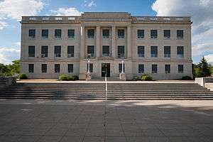
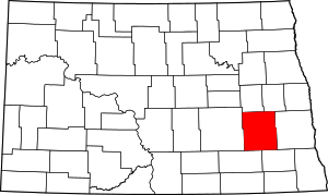
Barnes County, North Dakota
Barnes County is a county in the U.S. state of North Dakota. As of the 2010 United States Census, the population was 11,066.[1] Its county seat is Valley City.[2]
Barnes County | |
|---|---|
 | |
 Location within the U.S. state of North Dakota | |
 North Dakota's location within the U.S. | |
| Coordinates: 46°56′N 98°04′W | |
| Country | |
| State | |
| Founded | 1872 (created as Burbank) 1874 (renamed as Barnes) January 6, 1879 (organized) |
| Seat | Valley City |
| Largest city | Valley City |
| Area | |
| • Total | 1,513 sq mi (3,920 km2) |
| • Land | 1,492 sq mi (3,860 km2) |
| • Water | 22 sq mi (60 km2) 1.4% |
| Population (2010) | |
| • Total | 11,066 |
| • Estimate (2019) | 10,415 |
| • Density | 7.3/sq mi (2.8/km2) |
| Time zone | UTC−6 (Central) |
| • Summer (DST) | UTC−5 (CDT) |
| Congressional district | At-large |
| Website | www |
In 1872, the Dakota Territory legislature authorized Burbank County (named for governor John A. Burbank); in 1874 they renamed it Barnes County, for Alanson H. Barnes (1818–1890), an associate justice of the Territorial Court. It was organized at Valley City on January 6, 1879.[3]
Geography
The Sheyenne River flows southerly through the central part of Barnes County. The county terrain consists of rolling hills, carved with drainages, and dotted with lakes and ponds. The area is largely devoted to agriculture.[4] The terrain slopes to the south and east; its highest point is on its upper west boundary line, at 1,535' (468m) ASL.[5] The county has a total area of 1,513 square miles (3,920 km2), of which 1,492 square miles (3,860 km2) is land and 22 square miles (57 km2) (1.4%) is water.[6]
Adjacent counties
- Griggs County – north
- Steele County – northeast
- Cass County – east
- Ransom County – southeast
- LaMoure County – southwest
- Stutsman County – west
Protected areas[4]
- Clausen Springs Recreation Area
- Clausen Springs State Game Management Area
- Hobart Lake National Wildlife Refuge
- Koldak State Game Management Area
- Riparian Restoration Interpretative Site
- Stoney Slough National Wildlife Refuge
- Tomahawk Lake National Wildlife Refuge
Lakes[4]
- Lake Ashtabula
- Eckelson Lake
- Fox Lake
- Goose Lake
- Hobart Lake
- Island Lake
- Kee Lake
- Lake Benson
- Meadow Lake
- Moon Lake
- Mud Lake
- Round Lake
- Saint Marys Lake
- Sanborn Lake
- Tomahawk Lake
Demographics
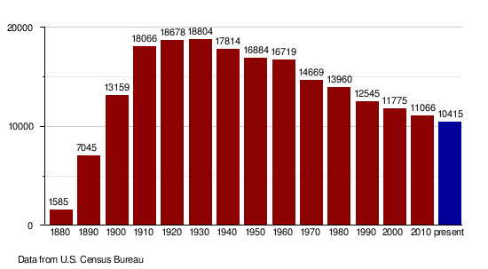
| Historical population | |||
|---|---|---|---|
| Census | Pop. | %± | |
| 1880 | 1,585 | — | |
| 1890 | 7,045 | 344.5% | |
| 1900 | 13,159 | 86.8% | |
| 1910 | 18,066 | 37.3% | |
| 1920 | 18,678 | 3.4% | |
| 1930 | 18,804 | 0.7% | |
| 1940 | 17,814 | −5.3% | |
| 1950 | 16,884 | −5.2% | |
| 1960 | 16,719 | −1.0% | |
| 1970 | 14,669 | −12.3% | |
| 1980 | 13,960 | −4.8% | |
| 1990 | 12,545 | −10.1% | |
| 2000 | 11,775 | −6.1% | |
| 2010 | 11,066 | −6.0% | |
| Est. 2019 | 10,415 | [7] | −5.9% |
| US Decennial Census[8] 1790-1960[9] 1900-1990[10] 1990-2000[11] 2010-2019[1] | |||
2000 census
As of the 2000 United States Census there were 11,775 people, 4,884 households, and 3,115 families in the county. The population density was 8 people per square mile (3/km²). There were 5,599 housing units at an average density of 4 per square mile (1/km²). The racial makeup of the county was 97.91% White, 0.45% Black or African American, 0.76% Native American, 0.19% Asian, 0.12% from other races, and 0.57% from two or more races. 0.54% of the population were Hispanic or Latino of any race. 40.3% were of German and 34.0% Norwegian ancestry.
There were 4,884 households out of which 27.40% had children under the age of 18 living with them, 53.90% were married couples living together, 6.80% had a female householder with no husband present, and 36.20% were non-families. 31.50% of all households were made up of individuals and 15.90% had someone living alone who was 65 years of age or older. The average household size was 2.29 and the average family size was 2.89.
The county population contained 22.30% under the age of 18, 11.30% from 18 to 24, 23.00% from 25 to 44, 23.60% from 45 to 64, and 19.80% who were 65 years of age or older. The median age was 41 years. For every 100 females there were 96.80 males. For every 100 females age 18 and over, there were 95.40 males.
The median income for a household in the county was $31,166, and the median income for a family was $42,149. Males had a median income of $28,504 versus $18,447 for females. The per capita income for the county was $16,566. About 6.40% of families and 10.80% of the population were below the poverty line, including 10.90% of those under age 18 and 10.90% of those age 65 or over.
2010 census
As of the 2010 United States Census, there were 11,066 people, 4,826 households, and 2,927 families residing in the county.[12] The population density was 7.4 inhabitants per square mile (2.9/km2). There were 5,704 housing units at an average density of 3.8 per square mile (1.5/km2).[13] The racial makeup of the county was 96.4% white, 0.8% black or African American, 0.7% American Indian, 0.5% Asian, 0.2% from other races, and 1.4% from two or more races. Those of Hispanic or Latino origin made up 1.1% of the population.[12] In terms of ancestry, 48.4% were German, 37.2% were Norwegian, 8.3% were Irish, 5.2% were English, and 2.7% were American.[14]
Of the 4,826 households, 24.8% had children under the age of 18 living with them, 50.8% were married couples living together, 6.4% had a female householder with no husband present, 39.3% were non-families, and 32.9% of all households were made up of individuals. The average household size was 2.19 and the average family size was 2.79. The median age was 44.3 years.[12]
The median income for a household in the county was $41,773 and the median income for a family was $59,558. Males had a median income of $42,575 versus $30,361 for females. The per capita income for the county was $26,152. About 6.4% of families and 12.0% of the population were below the poverty line, including 12.6% of those under age 18 and 14.6% of those age 65 or over.[15]
Population by decade
Communities
Cities
Unincorporated communities
Townships
- Alta
- Anderson
- Ashtabula
- Baldwin
- Binghampton
- Brimer
- Cuba
- Dazey
- Eckelson
- Edna
- Ellsbury
- Getchell
- Grand Prairie
- Green
- Greenland
- Hemen
- Hobart
- Lake Town
- Mansfield
- Marsh
- Meadow Lake
- Minnie Lake
- Nelson
- Noltimier
- Norma
- Oakhill
- Oriska
- Pierce
- Potter
- Raritan
- Rogers
- Rosebud
- Sibley Trail
- Skandia
- Spring Creek
- Springvale
- Stewart
- Svea
- Thordenskjold
- Uxbridge
- Valley
- Weimer
Notable people
- Frank White, 8th Governor of North Dakota and Treasurer of the United States.
- Peggy Lee, singer & actress
- Earl Pomeroy, U.S. Congressman
- Morley Nelson, conservationist
Politics
Barnes County voters have been reliably Republican for decades. In only one national election since 1936 has the county selected the Democratic County candidate.
| Year | Republican | Democratic | Third parties |
|---|---|---|---|
| 2016 | 59.1% 3,160 | 29.9% 1,597 | 11.0% 587 |
| 2012 | 53.7% 2,964 | 43.4% 2,394 | 3.0% 164 |
| 2008 | 49.6% 2,826 | 48.1% 2,741 | 2.2% 127 |
| 2004 | 60.9% 3,541 | 37.6% 2,186 | 1.5% 86 |
| 2000 | 60.1% 3,452 | 33.6% 1,933 | 6.3% 363 |
| 1996 | 44.8% 2,449 | 42.4% 2,317 | 12.8% 702 |
| 1992 | 42.3% 2,728 | 32.9% 2,124 | 24.8% 1,597 |
| 1988 | 55.5% 3,631 | 43.7% 2,858 | 0.9% 57 |
| 1984 | 62.8% 4,348 | 36.2% 2,507 | 1.0% 70 |
| 1980 | 59.8% 4,392 | 29.0% 2,128 | 11.3% 826 |
| 1976 | 53.8% 4,011 | 44.5% 3,321 | 1.7% 130 |
| 1972 | 61.1% 4,518 | 38.0% 2,804 | 0.9% 67 |
| 1968 | 56.3% 3,831 | 38.6% 2,623 | 5.2% 351 |
| 1964 | 42.6% 2,987 | 57.2% 4,007 | 0.2% 14 |
| 1960 | 57.7% 4,403 | 42.3% 3,223 | 0.0% 3 |
| 1956 | 62.0% 4,475 | 37.8% 2,730 | 0.2% 14 |
| 1952 | 71.8% 5,534 | 27.5% 2,120 | 0.6% 49 |
| 1948 | 51.3% 3,385 | 43.9% 2,892 | 4.8% 317 |
| 1944 | 55.6% 3,696 | 43.9% 2,922 | 0.5% 35 |
| 1940 | 57.7% 4,649 | 42.0% 3,384 | 0.4% 29 |
| 1936 | 30.0% 2,324 | 57.9% 4,484 | 12.1% 938 |
| 1932 | 33.0% 2,527 | 63.0% 4,833 | 4.0% 307 |
| 1928 | 53.0% 3,755 | 46.5% 3,293 | 0.5% 35 |
| 1924 | 51.5% 3,205 | 5.6% 346 | 43.0% 2,677 |
| 1920 | 80.3% 5,150 | 17.2% 1,101 | 2.6% 165 |
| 1916 | 45.1% 1,467 | 51.6% 1,678 | 3.4% 109 |
| 1912 | 24.7% 570 | 40.8% 940 | 34.5% 796 |
| 1908 | 62.1% 1,786 | 34.6% 996 | 3.3% 96 |
| 1904 | 76.1% 2,041 | 16.8% 451 | 7.1% 189 |
| 1900 | 53.8% 1,324 | 43.7% 1,077 | 2.5% 61 |
References
- "State & County QuickFacts". United States Census Bureau. Archived from the original on September 5, 2015. Retrieved October 31, 2013.
- "Find a County". National Association of Counties. Archived from the original on May 31, 2011. Retrieved June 7, 2011.
- "County History". North Dakota.gov. The State of North Dakota. Archived from the original on February 2, 2015. Retrieved February 2, 2015.
- Barnes County ND Google Maps (accessed 13 February 2019)
- ""Find an Altitude" Barnes County ND - Google Maps (accessed 13 February 2019)". Archived from the original on May 21, 2019. Retrieved February 13, 2019.
- "2010 Census Gazetteer Files". US Census Bureau. August 22, 2012. Archived from the original on January 29, 2015. Retrieved January 27, 2015.
- "Population and Housing Unit Estimates". Retrieved March 31, 2020.
- "US Decennial Census". US Census Bureau. Retrieved January 27, 2015.
- "Historical Census Browser". University of Virginia Library. Retrieved January 27, 2015.
- Forstall, Richard L., ed. (March 27, 1995). "Population of Counties by Decennial Census: 1900 to 1990". US Census Bureau. Retrieved January 27, 2015.
- "Census 2000 PHC-T-4. Ranking Tables for Counties: 1990 and 2000" (PDF). US Census Bureau. April 2, 2001. Retrieved January 27, 2015.
- "Profile of General Population and Housing Characteristics: 2010 Demographic Profile Data". US Census Bureau. Archived from the original on February 13, 2020. Retrieved March 14, 2016.
- "Population, Housing Units, Area, and Density: 2010 - County". US Census Bureau. Archived from the original on February 13, 2020. Retrieved March 14, 2016.
- "Selected Social Characteristics in the US – 2006-2010 American Community Survey 5-Year Estimates". US Census Bureau. Archived from the original on February 13, 2020. Retrieved March 14, 2016.
- "Selected Economic Characteristics – 2006-2010 American Community Survey 5-Year Estimates". US Census Bureau. Archived from the original on February 13, 2020. Retrieved March 14, 2016.
- Leip, David. "Atlas of US Presidential Elections". uselectionatlas.org. Retrieved April 12, 2018.
External links
- Barnes County, North Dakota official website
- Barnes County maps, Sheet 1 (southern) and Sheet 2 (northern), North Dakota DOT
Places adjacent to Barnes County, North Dakota | ||||||||||
|---|---|---|---|---|---|---|---|---|---|---|
| ||||||||||
Municipalities and communities of Barnes County, North Dakota, United States | ||
|---|---|---|
| Cities | Map of North Dakota highlighting Barnes County | |
| Townships |
| |
| Unincorporated communities | ||
| Footnotes | ‡This populated place also has portions in an adjacent county or counties | |

| Authority control |
|
|---|