Rugby, North Dakota
Rugby is a city in, and the county seat of, Pierce County, North Dakota, United States. The population was 2,876 at the 2010 census,[5] making it the eighteenth largest city in North Dakota. Rugby was founded in 1886.
Rugby, North Dakota | |
|---|---|
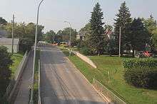
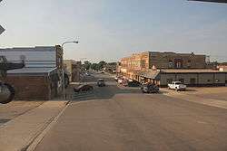 Downtown Rugby | |
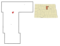 Location of Rugby, North Dakota | |
| Coordinates: 48°22′2″N 99°59′46″W | |
| Country | United States |
| State | North Dakota |
| County | Pierce |
| Government | |
| • Mayor | Susan Steinke |
| Area | |
| • Total | 1.94 sq mi (5.02 km2) |
| • Land | 1.94 sq mi (5.02 km2) |
| • Water | 0 sq mi (0 km2) |
| Elevation | 1,549 ft (472 m) |
| Population | |
| • Total | 2,876 |
| • Estimate (2018)[4] | 2,683 |
| • Density | 1,500/sq mi (570/km2) |
| Time zone | UTC−6 (Central (CST)) |
| • Summer (DST) | UTC−5 (CDT) |
| ZIP code | 58368 |
| Area code(s) | 701 |
| FIPS code | 38-68860 |
| GNIS feature ID | 1031031[2] |
| Highways | US 2, ND 3 |
| Website | Rugby |
Rugby is often billed as the geographic center of North America.[6][7]
History
Rugby was founded in 1886 at a junction on the Great Northern Railway, where a branch line to Bottineau met the main line. The railroad promoters initially platted the town as Rugby Junction, getting the name Rugby from the town of Rugby in Warwickshire, England.[8] It was one of several sites along the Great Northern's transcontinental route between Devils Lake and Minot that were named after places in England (the others were Berwick, Leeds, Knox, Norwich, Penn, Surrey, Churches Ferry, Tunbridge, and York). When the community became a city, the Junction was dropped from the name.
North Dakota's first permanent settlers arrived in 1812 from the Earl of Selkirk's colony in neighboring Rupert's Land. As farmers, they were more advanced than many of their contemporaries in the rest of the United States, having adopted sophisticated farming methods and machinery. Many of these implements, including an early McCormick Deering threshing machine, have found their way to the restored Pioneer Village in Rugby.
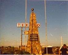
In 1931, the town of Rugby erected a 15-foot-tall (4.6 m) rock obelisk marking the "Geographical Center of North America". This was moved to a slightly different location in or after 1971. According to a listing by the U.S. Geological Survey, Rugby is actually approximately 15 miles (24 km) from the geographic center of North America (6 miles (9.7 km) west of Balta), and even this designation carries no official status.[9]
Geography
Rugby is located in eastern Pierce County at the intersection of U.S. Route 2 and North Dakota Highway 3. The Great Northern Railroad line passes through the community. Minot lies 66 miles to the west along route 2.[10]
According to the United States Census Bureau, the city has a total area of 1.94 square miles (5.02 km2), all of it land.[1] Rugby claims to be the geographic center of North America and a monument stands in the city to signify this. The monument features flags of the United States, Canada, and Mexico. However, modern calculations that take on account the distortions caused by cartographic projections show that center is 145 miles southwest of Rugby, in a town called Center, North Dakota.[11]
Transportation
Rail
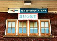
Amtrak, the national passenger rail system, serves a station in Rugby via its Empire Builder, a once-daily train in each direction between Portland/Seattle and Chicago.
Highway
U.S. Route 2 and North Dakota Highway 3 serve the Rugby area.
Demographics
| Historical population | |||
|---|---|---|---|
| Census | Pop. | %± | |
| 1900 | 487 | — | |
| 1910 | 1,630 | 234.7% | |
| 1920 | 1,424 | −12.6% | |
| 1930 | 1,512 | 6.2% | |
| 1940 | 2,215 | 46.5% | |
| 1950 | 2,907 | 31.2% | |
| 1960 | 2,972 | 2.2% | |
| 1970 | 2,889 | −2.8% | |
| 1980 | 3,335 | 15.4% | |
| 1990 | 2,909 | −12.8% | |
| 2000 | 2,939 | 1.0% | |
| 2010 | 2,876 | −2.1% | |
| Est. 2018 | 2,683 | [4] | −6.7% |
| U.S. Decennial Census[12] 2018 Estimate[13] | |||
2010 census
As of the census[3] of 2010, there were 2,876 people, 1,239 households, and 697 families living in the city. The population density was 1,482.5 inhabitants per square mile (572.4/km2). There were 1,407 housing units at an average density of 725.3 per square mile (280.0/km2). The racial makeup of the city was 91.9% White, 0.3% African American, 5.8% Native American, 0.9% from other races, and 1.1% from two or more races. Hispanic or Latino of any race were 1.3% of the population.
There were 1,239 households of which 23.2% had children under the age of 18 living with them, 46.2% were married couples living together, 6.9% had a female householder with no husband present, 3.2% had a male householder with no wife present, and 43.7% were non-families. 39.7% of all households were made up of individuals and 20.2% had someone living alone who was 65 years of age or older. The average household size was 2.11 and the average family size was 2.83.
The median age in the city was 47 years. 20% of residents were under the age of 18; 6.1% were between the ages of 18 and 24; 21.1% were from 25 to 44; 26.2% were from 45 to 64; and 26.6% were 65 years of age or older. The gender makeup of the city was 48.7% male and 51.3% female.
2000 census
As of the census of 2000, there were 2,939 people, 1,291 households, and 765 families living in the city. The population density was 1,520.1 inhabitants per square mile (586.9/km2). There were 1,434 housing units at an average density of 741.7 per square mile (286.4/km2). The racial makeup of the city was 98.09% White, 1.02% Native American, 0.37% Asian, 0.03% from other races, and 0.48% from two or more races. Hispanic or Latino of any race were 0.44% of the population.
The top six ancestry groups in the city are German (49.6%), Norwegian (40.5%), Irish (5.3%), English (4.0%), Russian (3.7%), French (3.6%).
There were 1,291 households out of which 26.6% had children under the age of 18 living with them, 49.0% were married couples living together, 8.0% had a female householder with no husband present, and 40.7% were non-families. 37.3% of all households were made up of individuals and 21.2% had someone living alone who was 65 years of age or older. The average household size was 2.17 and the average family size was 2.89.
In the city, the population was spread out with 23.1% under the age of 18, 5.4% from 18 to 24, 23.1% from 25 to 44, 20.2% from 45 to 64, and 28.1% who were 65 years of age or older. The median age was 44 years. For every 100 females, there were 86.8 males. For every 100 females age 18 and over, there were 81.3 males.
The median income for a household in the city was $25,482, and the median income for a family was $35,745. Males had a median income of $25,885 versus $18,510 for females. The per capita income for the city was $14,380. About 9.6% of families and 13.7% of the population were below the poverty line, including 11.6% of those under age 18 and 19.1% of those age 65 or over.
Notable people
- Todd Brandt, radio personality with The Todd and Tyler Radio Empire
- Nichi Farnham, Maine State Senator
- Don Gaetz, Florida politician
- Larry Watson, poet, writer, and educator
Education
The city of Rugby is served by Ely Elementary School[14] and Rugby High School. Little Flower Catholic School[15] is also in Rugby.
Sites of interest
- Geographical center of North America – Rugby is located in the geographical center of North America. There is a cairn marking this spot. Note: The validity of this claim is disputed by a mathematical analysis.[16]
- Prairie Village Museum houses some of Pierce County's oldest historical buildings and artifacts including the 1886 Great Northern Railroad Depot.
- The Victorian Dress Museum – The building that houses the museum is listed in the National Register of Historic Places.
Climate
This climatic region is typified by large seasonal temperature differences, with warm to hot (and often humid) summers and cold (sometimes severely cold) winters. According to the Köppen Climate Classification system, Rugby has a humid continental climate, abbreviated "Dfb" on climate maps.[17]
References
- "US Gazetteer files 2010". United States Census Bureau. Archived from the original on January 12, 2012. Retrieved June 14, 2012.
- U.S. Geological Survey Geographic Names Information System: Rugby, North Dakota
- "U.S. Census website". United States Census Bureau. Retrieved June 14, 2012.
- "Population and Housing Unit Estimates". Retrieved May 29, 2019.
- "2010 Census Redistricting Data (Public Law 94-171) Summary File". American FactFinder. United States Census Bureau. Retrieved May 2, 2011.
- "North Dakota Geologic Survey". www.dmr.nd.gov. Retrieved January 16, 2019.
- "Community fact survey : Rugby, N. Dak., geographical center of North America". www.digitalhorizonsonline.org. Retrieved January 16, 2019.
- Wick, Douglas A. "Rugby (Pierce County)". North Dakota Place Names. Retrieved May 5, 2011.
- "Geographic Centers". USGS Geography Products. U.S. Geological Survey. 2001. Archived from the original on May 27, 2010. Retrieved November 19, 2009.
- Rugby, ND, 7.5 Minute Topographic Quadrangle, USGS 1955 (1980 rev.)
- Yin, Steph (January 25, 2017). "North America's Geographical Center May Be in". The New York Times. Retrieved April 11, 2017.
- United States Census Bureau. "Census of Population and Housing". Retrieved September 7, 2013.
- "Population Estimates". United States Census Bureau. Retrieved October 3, 2018.
- "Ely Elementary School". rugby.k12.nd.us. Retrieved January 16, 2019.
- "Little Flower Catholic School - "To teach as Jesus did" - Little Flower Catholic School". little-flower.k12.nd.us. Retrieved January 16, 2019.
- Yin, Steph (January 25, 2017). "North America's Geographical Center May Be in a North Dakota Town Called Center". Retrieved January 16, 2019 – via NYTimes.com.
- "Rugby, North Dakota Köppen Climate Classification (Weatherbase)". Weatherbase. Retrieved January 16, 2019.
External links
| Wikimedia Commons has media related to Rugby, North Dakota. |
| Wikivoyage has a travel guide for Rugby (North Dakota). |
- City of Rugby official website
- Cairn marking Center of North America
- The Pierce County Tribune
- Rugby, ND Article at Dakota Search
Municipalities and communities of Pierce County, North Dakota, United States | ||
|---|---|---|
| Cities | 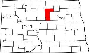 Map of North Dakota highlighting Pierce County | |
| Townships |
| |
| CDPs | ||
| Unorganized territories |
| |
| Unincorporated communities |
| |
